Three examples of current graduate geophysical research projects at Carleton University, Ottawa
Editorial note: With many faculty staff away this summer on field trips, we were pleased to procure the following research notes from current graduate students at Carleton University.
Integrating airborne electromagnetic and gravity data for bedrock topography correction – RAYMOND CARON, EARTH SCIENCE PH.D. CANDIDATE
A research collaboration between Carleton University, the Federal Government, and Sander Geophysics headed by Dr. Claire Samson, Dr. Michel Chouteau, Dr. Martin Bates, and Ph.D. Candidate Raymond Caron, is currently working on a methodology that applies the helicopter- borne transient electromagnetic (HTEM) method to measuring the thickness of glaciolacustrine overburden overlying Precambrian bedrock for the purpose of correcting airborne gravity measurements for lateral variations in overburden thickness. In Northern Ontario the Precambrian bedrock topography is largely obscured by a glacially derived overburden that changes in thickness independently of the bedrock topography. These variations in overburden thickness can on occasion result in the creation of a gravity anomaly that approaches the size and amplitude of an ore body and can be mistaken for one during interpretation.
HTEM systems that are configured to resolve a near-surface target are optimized to record the early time of an electromagnetic (EM) response from the ground. These systems are typically configured with a quick-turn off time that is often characterized by a square waveform and a lower transmitter moment that enables measurements of an EM response generated by the overburden. The response can then be inverted to determine the thickness of the overburden. In Northern Ontario the glaciolacustrine overburden is predominantly composed of Clay, Sand, and Till which have been measured in-situ to have average resistivity’s of 47.3 ± 6.7 Ω•m, 251 ± 70 Ω•m, and 123 ± 35 Ω•m, respectively (Palacky, 1992).
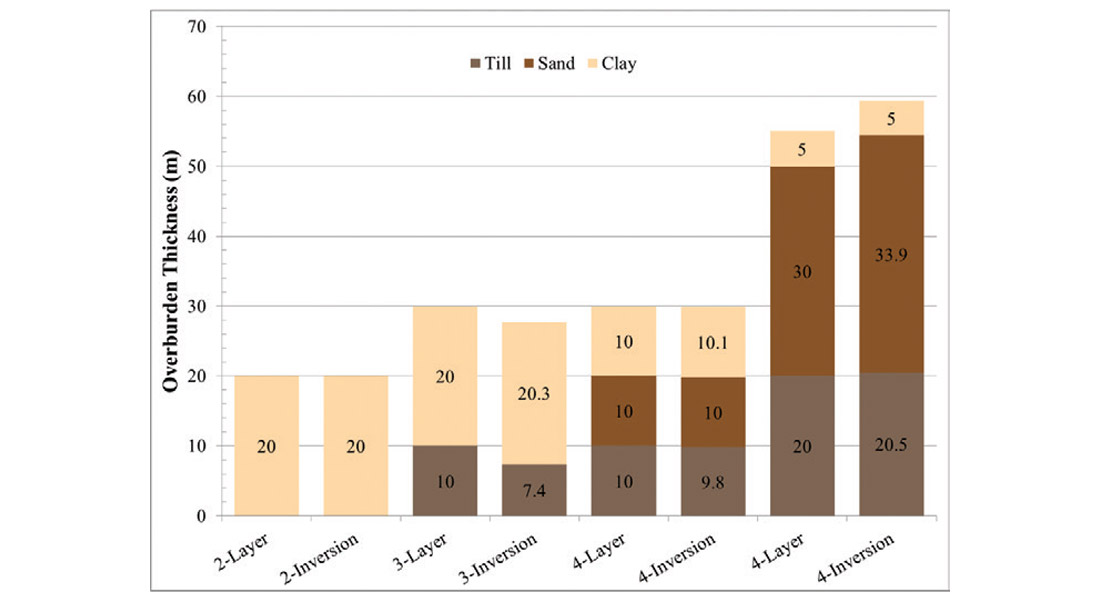
Figure 1 shows 1D inversions of overburden scenarios that were forward modelled with noise added. The forward modelling was done using AirBeo of the P233F EM suite developed by CSIRO. The noise was modelled following a method developed by Auken et al. in 2008. The overburden scenarios were modelled with 2, 3, and 4 layers where the bottom-most layer is a half-space used to model the bedrock and has been assigned a resistance of 10,000 Ω•m. Results of the inversions of the modelled data with noise indicates that both the thickness of the overburden and the layers of sediment can be measured within 10% of the overburden and layer thicknesses in each scenario.
Characterizing the location and geometry of injected CO2 in a saline reservoir over time through the use of downhole seismic methods – KYLE HARRIS, EARTH SCIENCE PH.D. CANDIDATE
Aquistore is a CO2 injection site located near Estevan, Saskatchewan, Canada, where captured CO2 will be stored in a saline aquifer at a depth of approximately 3000 m. The CO2 captured from SaskPower’s Boundary Dam Power Station will be transported via pipeline to the Aquistore injection well and storage site. It is expected that SaskPower’s Boundary Dam Power Station will capture approximately 3,000 tonnes/day of CO2 using an amine-based system, and of this, initially up to 2,000 tonnes/day may be targeted for dedicated geologic storage. Surface and downhole (VSP) seismic surveys will be performed to monitor the location and geometry of the CO2 plume over time to evaluate the integrity of the reservoir and caprock.
My research is focused on the use of a novel technology, Distributed Acoustic Sensing (DAS), which employs fiber optic cables fixed down a well to use as simulated geophones at 2 cm intervals. Particularly, through my work I intend to (1) establish the feasibility of DAS to monitor CO2 reservoirs at great depths in comparison with traditional geophone methods, (2) establish 3D VSP processing and imaging techniques to adequately characterize geometry of the CO2 plume, and (3) perform time-lapse analysis of the CO2 injection and plume migration. Though feasibility projects have previously been undertaken, this will be the first work to use DAS VSP technology to conduct long-term time-lapse monitoring at a carbon dioxide capture and storage site.
Identifying and characterizing the response from known volcanogenic massive sulphide (VMS) ore lenses using VSP data – DAVE MELANSON, EARTH SCIENCE M.SC CANDIDATE
My project with the Geological Survey of Canada and Carleton University involves comparing vertical seismic profile (VSP) data with 3D finite difference modeled analogues to identify and characterize the response from known volcanogenic massive sulphide (VMS) ore lenses. For this study, multi-offset 3-component VSP data using dynamite and Vibroseis sources in three deviated wells in the Flin Flon, Manitoba, mining camp were used. Boundaries between the greenstone host rocks and the 85.5 Mt Flin Flon-Callinan-777 VMS ore system provide the strong contrasts in acoustic impedance from which seismic reflections originate. After processing, the VSP data contains observable reflections which are compared with modeled data and interpreted.
The Flin Flon mining camp has been extensively mapped, drilled, mined and targeted by geophysical surveys for decades, leading to a wealth of multidisciplinary data. Several voxel models were constructed from these data and used in 3D finite difference-modeled simulations of the VSP surveys. The number of distinct geological units used in the 3D voxel model was increased incrementally to determine the effects on seismic response of major rock units and massive sulphide ore. The outputs of this simulation method were synthetic VSP shot-gathers, which capture particle motions at receiver stations. In addition, the simulated propagation and scattering of the seismic wavefields could be visualized in 2D and 3D using the output from the simulations taken at sequential time steps. These synthetic shot-gathers were found to be directly comparable to the VSP field data. By integrating the modeled results into the interpretation process, we were able to identify and characterize a response from the mine horizon and from the ore lenses in the VSP field data.

Related Reading


Join the Conversation
Interested in starting, or contributing to a conversation about an article or issue of the RECORDER? Join our CSEG LinkedIn Group.
Share This Article