Abstract
The exploration history of the discovery of two deposits beneath the Phanerozoic cover of the Flin Flon – Snow Lake volcanogenic massive sulphide (VMS) Belt in Manitoba and Saskatchewan is presented. Due to a lack of outcrops of the host rocks, geophysical exploration techniques were key to the discoveries. Both discoveries are attributed to geophysical techniques and both used arguably the best airborne electromagnetic technology at the time to detect the sulphide mineralization for ground follow-up and then drill testing. But it took many tries or near misses over a long period of time, either by other companies or by the discoverers in the same area, before the discovery hole was drilled. The exploration history of the McIlvenna Bay Deposit and of the Reed Mine Deposit are presented to show the perseverance required to find these deposits.
Introduction
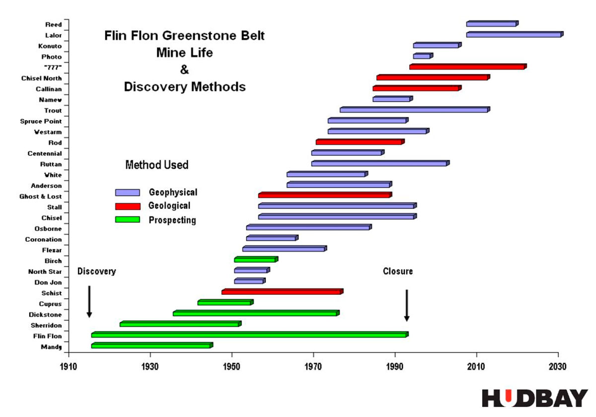
The Flin Flon – Snow Lake Proterozoic VMS Belt is one of the most prolific VMS Belts in the world. It hosts over 400 million tonnes of sulphide ore from 27 copper-zinc mines (Gibson et al, 2013). Most of these mines are in the exposed portions of the belt which is approximately 250 km long and 75 km wide. The two most recent mines found in the belt are the Reed Mine (discovered by VMS Ventures) and the Lalor Mine (discovered by Hudbay), both in 2007 and both operated by Hudbay.
As shown in Figure 1 (from Gilmore and Wood, 2012), geophysics plays a very large role in mine discoveries in the Flin Flon – Snow Lake Belt. The method of discovery of 19 of the 31 mines in Figure 1 is attributed to geophysics (31 mines are listed above, as opposed to the 27 copper-zinc mines because nickel rich and gold mines are included).
About 25 km south of both Flin Flon and Snow Lake, the Proterozoic rocks which host the mineralization becomes buried by a Phanerozoic sequence of sedimentary rocks which gets progressively thicker to the south. It was well known that the Proterozoic rocks which host the large VMS deposits, such as the Flin Flon Mine and 777 Mine, extend beneath the Phanerozoic cover. Aeromagnetic maps clearly show the same magnetic patterns and texture on both sides of the unconformity, as the sedimentary cover is virtually non-magnetic. The magnetic patterns and textures show increasing attenuation toward the south due to the magnetic bedrock being deeper. Further south, drill holes and wells drilled to the crystalline basement by oil companies, or perhaps potash or coal exploration companies, confirm that the favourable geology extends beneath the Phanerozoic for a considerable distance.
Exploration for economic deposits beneath the Phanerozoic occurred due to increased competition for land packages in the exposed areas, and due to the exploration industry’s use of geophysical techniques. Without the crystalline bedrock host being exposed, geophysical methods played the crucial first step in detecting the mineral deposits. The VMS deposits of the Flin Flon – Snow Lake Belt are conductive and, in most cases magnetic, making them ideal targets for airborne electromagnetic and magnetic surveys.
A number of deposits and mines have been discovered beneath the Phanerozoic in the Flin Flon Belt. Prior to the Reed Mine, only two other mines, Spruce Point Mine discovered in 1972, and Namew Lake Mine discovered in 1984, both of Hudson’s Bay Mining and Smelting (Hudbay), were discovered beneath the Phanerozoic cover. The Namew Lake Mine produced 2.6 million tonnes of 0.9% Cu and 2.44% Ni from 1988 to 1993 (Nickel in Manitoba, 2018). It was found by Hudbay’s proprietary in-house airborne electromagnetic system with ground geophysics follow-up and diamond core drilling. Spruce Point Mine (1.593 million tonnes of 2.35% Cu and 2.185 Zn produced – Bamburak, 1990) was an airborne electromagnetic (AEM) INPUT (Baringer, 1962) anomaly, followed by ground EM follow-up prior to drill testing.
Airborne EM followed by ground EM, then drill testing, seems to be the modus operandi of exploration companies, then and to this date.
This paper will present the geophysical data from the Reed Mine Deposit and the McIlvenna Bay Deposit. Each resulted from suitable target selection of airborne geophysical surveys, perhaps followed by ground geophysics, then drilling. But the exploration steps undertaken before the discovery drill hole, or deciding where to conduct the airborne geophysical survey, played a much more important role in their success.
Regional Geology
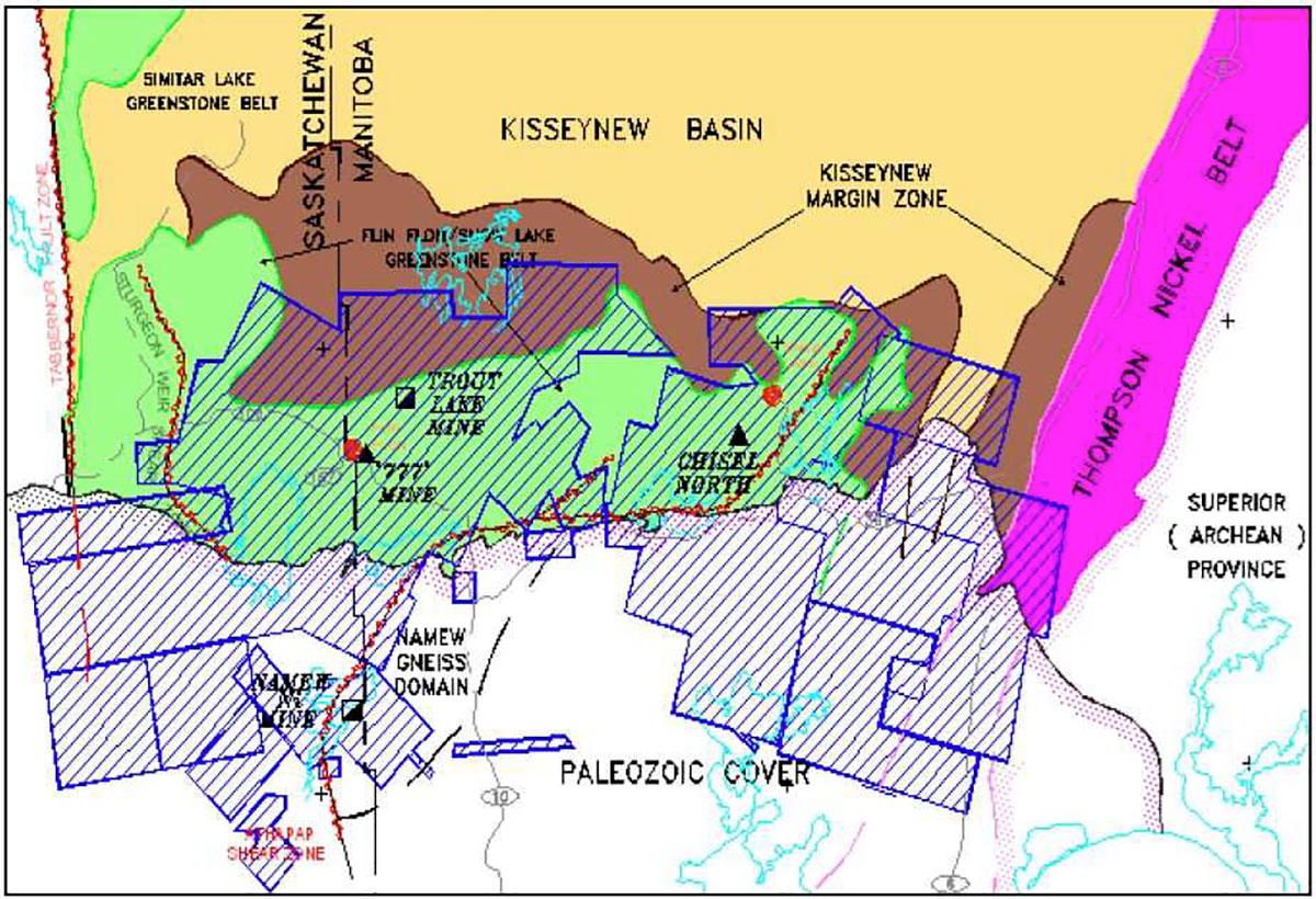
The Flin Flon – Snow Lake Belt, located in Manitoba and Saskatchewan, is in the juvenile internal zone, of the Trans-Hudson Orogen. It consists of Paleoproterozoic volcanic, plutonic and minor sedimentary rocks. The areal extent of the exposed portion of the belt is approximately 250 km East-West X 75 km North-South. It is in tectonic contact with the gneissic Kisseynew Domain to the north, and is unconformably overlain by Ordovician aged dolomite to the south.
The Flin Flon – Snow Lake Belt is composed of structurally juxtaposed volcanic and sedimentary assemblages that were emplaced in a variety of tectonic environments. The major 1.92-1.88 Ga components include areally significant juvenile arc and juvenile ocean-floor back arc rocks, and minor ocean plateau/ocean island basalt. The juvenile arc assemblage comprises tholeiitic, calc-alkaline and lesser shoshonitic and boninitic rocks. Ocean-floor basalt sequences are exclusively tholeiitic. Evolved arc assemblages and Archean crustal slices are present within the Flin Flon – Snow Lake Belt, as minor components.
Collectively, these tectonostratigraphic assemblages comprise the Snow Lake arc assemblage, the Amisk collage, Hanson Lake block and the Glennie Domain, all amalgamated at ca. 1.87-1.85 Ga as a result of intraoceanic accretion (Lewry and Collerson 1990; Lucas et al. 1996).
The 1.92-1.87 Ga tectonostratigraphic assemblages include those with juvenile arc, juvenile ocean-floor and evolved arc affinities. This has important economic implications, as not all of the tectonostratigraphic assemblages are equally endowed with mineral deposits. For example, all of the mined VMS base-metal deposits in the Flin Flon Belt are associated with the juvenile arc volcanic rocks. VMS deposits, hosted by juvenile island arc assemblages, occur at major stratigraphic and compositional breaks in the volcanic sequence, and are associated with felsic volcanic rocks; the stratigraphic footwall is comprised of coarse volcaniclastic rocks (Syme and Bailes, 1993).
General Exploration Methodology
The two deposits studied in this paper, and most of the deposits mined in the Flin Flon – Snow Lake Belt, are volcanogenic massive sulphide (VMS) deposits.
A number of papers have been written on geophysical signatures of VMS deposits (Airo, 2015; Morgan, 2012; Ford et al, 2007; Boivin, 2007). The important physical properties to note for VMS exploration beneath the Phanerozoic cover are: 1) that the carbonate rocks of the Phanerozoic cover are non-magnetic and resistive, 2) the economic sulphides are conductive, 3) the economic sulphides have an association with magnetite and pyrrhotite which makes them relatively magnetic, and 4) the felsic volcanic rocks which host the deposits are resistive and only slightly magnetic. There is a lot of ground where the limestone cover is thin enough for modern EM methods to detect the conductive VMS ore bodies.
In general, the land packages in the sub-Phanerozoic are large, and airborne EM methods have played an important first step in the exploration process, after land position has been decided. From the aeromagnetic maps, say, those published by the GSC, the various areas which had magnetic patterns suggestive of volcanic flows were initially targeted. Now, with more drill holes into the basement and additional geophysical information from previous explorers in certain areas, geological criteria have a greater input into ground selection. However, some of the very large airborne surveys, especially in the earlier days of airborne EM, suggests that a more blanket approach to exploration beneath the Phanerozoic, in which large areas are flown, evaluated, then the land positions obtained, is the norm.
Once flown, the EM anomalies were interpreted, mostly, on a profile-by-profile basis, followed by a ranking of the anomalies based on conductor length conductance, correlation to magnetic anomalies and complexity, and with other criteria that the exploration team developed. In general, shorter conductors (say, less than 1 km long) with moderate to good conductance, directly associated with a magnetic anomaly, and complicated (i.e. not having a uniform and simple thin-sheet response) were preferred. The rationale of the short conductor strike length was that very long conductors tended to be formational in nature; the geological processes which formed the conductors over tens of kilometers were not the favourable processes for many types of base metal deposits. It was also felt that an economic deposit of sufficient grade and thickness would produce a reasonable conductance, say above 20 siemens. The caveat here is that the mineralizing system, of which the mineral deposit is a small volume, can have a large range of conductances, some of which can be quite low. Lastly, almost all the Flin Flon – Snow Lake Belt ores are magnetic, due to the pyrrhotite and magnetite content. An association with a magnetic anomaly was a favourable indicator.
Many parts of the belt had been flown by Hudbay’s proprietary and Inco’s proprietary airborne electromagnetic (AEM) systems. Other explorers used commercial systems like Aerodat, Dighem, and INPUT (or Questor). Hudbay had operated their own airborne EM systems since the 1970s. Details of their systems are lacking, and are obtained from a quick review of their mineral assessment reports. They operated their own Beechcraft Super 18 aircraft with a single frequency EM transmitter in the nose and a three component EM receiver in a towed bird. This was upgraded several times, with the last version being installed in a DC-3. Also found in assessment reports were Hudbay airborne EM surveys where they had leased towed bird EM equipment from Hunting Airborne Geophysics Ltd. and flown it in a Sikorsky S55 helicopter (Manitoba Assessment Work Report #99523). In the 1990s, Hudbay flew the Flin Flon – Snow Lake Belt with the proprietary system owned by Anglo American called the Spectrem system (Leggatt et al., 2000), when Hudbay was a subsidiary of Anglo American.
Seasoned explorers in the area claim that the older AEM systems were able to locate some of these deposits, but for various reasons, they were not drill tested or discovered until more work was done, or after some other party had taken over the area. The Photo Lake deposit should have been detected in all of the previous airborne EM surveys which flew over it, due to its high conductivity and relatively near surface location. It was covered by a lake of almost the same size as the surface expression of the ore body, and there is always the suspicion that the EM responses over lakes are due to conductive lake bottom sediments and possibly due to the lake water (which under certain conditions can be conductive). Photo Lake Mine was discovered in 1994 following a proprietary AEM survey performed by Spectrem Air Limited on behalf of Hudson Bay Exploration and Development Company Limited (HBED) (Heine and Prouse, 1998). Kudos to the geophysicist who stood up and said that the modelling or EM response showed more than just conductive lake bottom sediments.
Some of the discoveries beneath the limestone cover prior to the Spectrem Air surveys were Limestone Bay (found by Esso) on Moose Lake, Kof Zone and Silvia Zone, southeast of Reed Lake (HBED 1960s and ‘70s vintage airborne EM with horizontal loop electromagnetic (HLEM) follow-up), and Namew Lake Nickel (1983 HBED – Hudbay’s proprietary fixed wing DC3 EM-30 with HLEM follow-up). Ground follow-up of Spectrem survey anomalies resulted in Watt's (1995), Harmin, Fenton (1998), Talbot (2003), Tower (2001), in Manitoba, and Suggi, Grassberry, Windy, Jazz, Archibald (1998 and later), in Saskatchewan. The Talbot Deposit is probably the deposit furthest to the south of the start of the Phanerozoic cover, some 60 km to the north. It is overlain by 90 to 100 m of Phanerozoic cover before the crystalline basement. Others, including Newmont, AMAX, MMR and probably Inco, surveyed the area with airborne geophysics and conducted ground follow-up prior to Hudbay’s Spectrem survey, in the 1990s, followed by HLEM follow-up and then discovery in 2003 (Bernier and Cole, 2018).
The list of discoveries beneath cover appears to encounter a lull in the 1980s. Other than the Namew Lake Mine and the McIlvenna Bay Deposit in the 1980s there was a poor success rate until the mid- to late 1990s when Hudbay flew the Spectrem surveys.
Reed Lake Mine
The Reed Lake Mine is located some 80 km from Flin Flon, just off of Provincial Highway 39. The published resource estimate is 2,550,000 tonnes of 4.52% Cu, 0.91% Zn, 0.64 g/t Au and 7.86 g/t Ag of indicated resource and 170,000 tonnes of 4.26% Cu, 0.52% Zn, 0.38 % Au/t and 4.55 g/t Ag inferred resource (Allen and Carter, 2011).
The Reed Mine Deposit is a volcanogenic massive sulphide deposit similar to that of past and current producing base metal deposits in the Flin Flon and Snow Lake Belt (Allen and Carter, 2011). The mineralized zone is overlain by distinctive layers of magnetite and chert. The sulphides are contained and underlain by weak to moderately altered felsic volcanic rocks. A fine- to medium-grained gabbro intrudes the sequence locally (Fedikow, 2009). The Proterozoic basement is overlain by 3 to 7 m of overburden, 15 to 20 m of dolomitic sandstone and 1 to 2 m of semi-consolidated to consolidated quartz-rich sandstone. The top 5 to 25 m of the basement rocks are deeply weathered (Allen and Carter, 2011).
The mineralization is described by Allen et al. (2011) as being generally fine- to medium-grained, disseminated to solid sulphides. The ore mineralization consists of pyrrhotite, pyrite, chalcopyrite, sphalerite and magnetite. Solid sulphides are more prevalent closer to the surface.
The magnetite and pyrrhotite in the ore are magnetic and the solid sulphides are very conductive, which explains the typical Flin Flon VMS geophysical signature.
Reed Lake Mine – Geophysical Exploration History
The area had been explored by Freeport Canadian Exploration Company Canada and by Hudson’s Bay Mining and Exploration (Manitoba Assessment Work Report #99449). The nearby Spruce Point Deposit, some 15 km to the east, was discovered in 1972. Freeport Canadian Exploration Company commissioned an airborne geophysical survey by Questor in 1972 and staked ground in the area. Drilling by Freeport identified a small VMS type deposit that is known as the ‘Highway Zone’.
Either the INPUT survey did not detect the Reed Mine Deposit, or the interpreter did not interpret an EM response in the location.
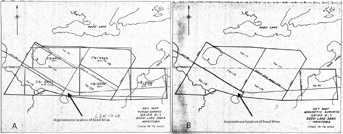
The ground geophysics of Turam EM (by Geosearch Consultants) and ground magnetometer survey that was conducted in Freeport Canadian Exploration Company’s exploration of the area detected the Reed Mine Deposit. It is not known why the anomaly was not drilled by either Freeport or Hudson’s Bay Mining and Exploration who took over the project area. Perhaps having map sheets at a scale of 1 inch to 200 feet made for a lot of maps, and the Turam anomaly was at bottom right corner of one map, with the corresponding magnetic anomaly on the bottom left corner of a different map (Kelly Gilmore – retired Hudbay Chief Geologist – personal communications). The four assessment reports filed on this project by Freeport (Manitoba Assessment Work Report #99449, 98523, 98467, and 92716) had a total of 1,400 line km of Turam and slightly more for the magnetics. Surveying with 400 foot spaced lines and plotted at 1:2,400 scale for Turam and magnetics separately made for a lot of paper maps. Index map sheets from Manitoba Assessment Work Report #98523 as shown in Figures 6A and 6B confirms that the Reed Mine location was plotted on different sheet layouts for the ground magnetics and Turam surveys. In the days of light tables for correlation of different parameters, and the search of coincident EM and magnetic responses, and lots of targets, it could be possible that this map layout caused the Reed Mine Deposit to be overlooked.
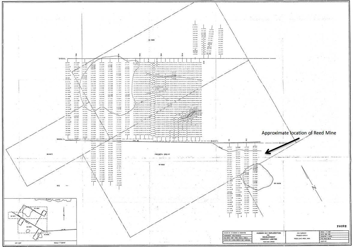
HBED conducted additional ground geophysical surveys and drilling after acquiring the property from Freeport. Hudbay, in 1981, conducted an HLEM survey to follow up on their own in-house airborne EM system (EM-30) anomalies and to better define previously located Turam trends. The HLEM surveying just missed the massive portion of the ore body (Manitoba Mineral Assessment Work Report #70222).
Note that the VTEMTM (Witherly et. al., 2004) response of the mine is between the small circular lake and the bend in the road (Figure 9). The rationale for Hudbay’s 1981 HLEM grid lines that just missed is not known. This could be due to a number of reasons, including plotting errors from their in-house EM-30 survey, or from a reinterpretation of the 1972 Questor airborne survey data, or perhaps from the line cutters who established the grid in the incorrect place.
Homestake explored in the area and flew an airborne geophysical survey in 1988, with ground geophysical surveying follow-up work just to the north of the Reed Mine Deposit.
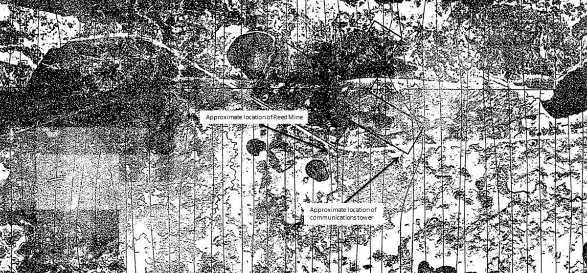
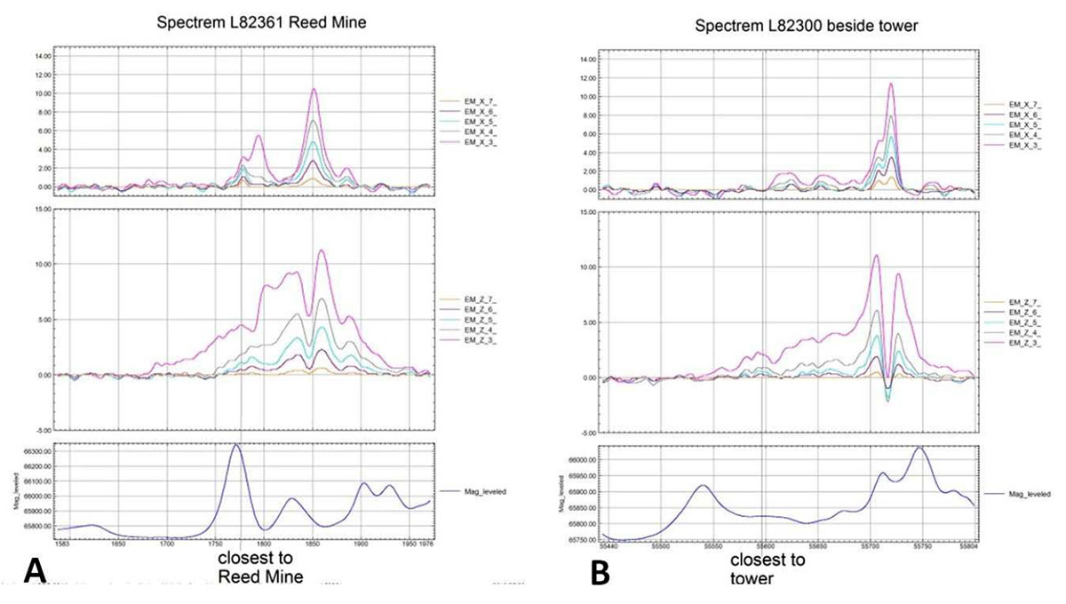
The Reed Lake orebody was also covered by a large Spectrem survey that was flown by Hudbay in 1995 (Manitoba Mineral Assessment Work Report # file 73859). The deposit was detected by the Spectrem survey in their Reed Lake A flying block, but the EM response was attributed to the response of the communications tower nearby which, judging by the responses on the map, affected the Spectrem system for quite a few lines.
Figure 8A shows the Spectrem line over closest to the Reed Mine Deposit and Figure 8B shows the Spectrem data over the line just to the west of the communications tower. While there is a clear anomalous response over the Reed Mine Deposit, a number of EM responses similar in amplitude and spatial wavelength to the Reed Mine Deposit are seen on the line close to the communications tower.
VMS Venture’s Exploration Rationale and Discovery
In 2006, VMS Ventures embarked on an exploration program beneath the Phanerozoic cover, with the Reed Lake area as one of many prospective areas that were obtained by staking or options. Their rationale was that there were 29 mines found in the Flin Flon Belt with only one of those (of VMS type deposit) beneath the Phanerozoic cover, which made the covered area underexplored. The exploration team recognized that advances in geophysics and geochemistry provided the targeting required to explore beneath the cover rocks (J. Roozendaal, President – VMS Ventures – personal communications).
The Reed Lake area was of interest due to the Spruce Point Mine, mined by HBMS from 1982 to 1988, some 15 km away and the Highway Zone (discovered in 1972, 73 – 250,000 tonnes of up to 2.5% Cu), just north of the highway which runs through the property. The previous 40 years of exploration in the immediate area had drill core which showed good alteration (J. Roozendaal – personal communications).
VMS Ventures Inc. conducted geochemical surveys over parts of the Dunlop Option in 2005 and 2006 to investigate some of the Spectrem anomalies on the Dunlop claims. VMS undertook an airborne geophysical survey over the property in early 2007 using Geotech’s VTEM system. The VTEM system at the time was a vertical component receiver system. Survey lines were flown 100 m apart in a NW to SE direction. Interpretation of the data consisted of EM anomaly picking on a profile-by-profile basis followed by a ranking of the anomalies based on conductor length, conductance, correlation to magnetic anomalies, and complexity. A number of well-defined conductors were identified.
The Reed Lake Deposit responded as a moderately conductive three line anomaly within an 800 m long, and much weaker, conductor. It was not selected as a high priority target by the consulting geophysicist to the project (personal recollection of the author who was the geophysical consultant to VMS Ventures at the time) as there were other more geophysically intriguing targets located on the survey block, and it was downgraded due to its proximity to the bend in the highway and the communications tower to the east.
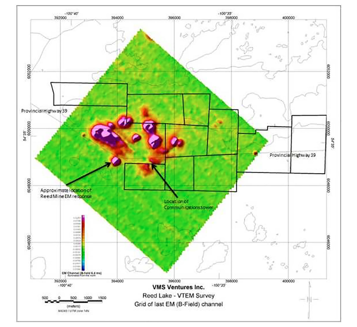
A map of the gridded last EM channel data with topographic features overlain, generated from the VTEM™ data (Manitoba Mineral Assessment Work Report #74580) shows the concern. Three smaller EM blips are located directly on the highway. Those, the communications tower, and fibre optic cable were causes of concern for the EM response of the Reed Mine.
The magnetic data from a larger VTEM survey the next year is shown in Figure 10 (from Manitoba Mineral Assessment Work Report #74793). The Reed Lake Deposit is a magnetic high. The access trail that goes right by the response was there from the 1970s when Freeport was drilling in the area.
Geochemical results near the Reed Lake Deposit upgraded the target (J. Roozendaal, personal communications). Plus, some of the better VTEM responses north of the highway had been drill tested by Freeport or Hudbay.

A field check plus GPS positioning of the highway and communications tower by John Roozendaal of VMS Ventures showed that the transmission tower was over one kilometer away to the east and that there were no anthropogenic sources in the vicinity of the Reed Mine VTEM responses. A fiber-optic line was laid down south of the highway, but it did not appear to produce an EM or magnetic response.
Simple plate modelling (see Figure 13), using the software program Maxwell by EMIT, was used to model the response on flight line 2410 to help VMS Ventures drill target the response. The magnetic data was not modelled, but its direct spatial correlation was very encouraging. Ground geophysics was not done prior to drill testing.
The first drill hole, collared on high ground in the vicinity, intersected 30 m of stringer sulphides with some chalcopyrite (VMS Ventures press release – Sept. 17, 2007). The follow-up drillhole, stepped 100 m to the north, also on high ground, intersected ore grade and widths.
Subsequent to the discovery, the land position was expanded and re-flown with a newer version of VTEM. Surface time domain electromagnetics (TDEM) work, ground magnetometer, ground gravity, induced polarization, and borehole EM surveys were also conducted to characterize the geophysical response of the deposit and to explore for additional mineralization. The rapid development of the deposit to obtain a resource calculation using multiple drill rigs meant that, while the ground and borehole geophysical survey results were of use, they did not materially impact exploration and deposit delineation efforts after the initial few drill holes.
As is usually the case with a new discovery, a number of small test or demonstration airborne surveys were conducted over the deposit after its discovery and prior to mining operations. These included airborne gravity gradiometry and z-axis tipper electromagnetic (ZTEMTM), (Lo and Zang, 2008) surveys.
McIlvenna Bay Deposit
The McIlvenna Bay Deposit is located on the western edge of the Flin Flon – Snow Lake Belt. It is located a short distance from the edge of the limestone cover. Published resources are 13.9 million tonnes of 1.28% Cu, 2.67% Zn, 0.49 g/t Au and 17.1 g/t Ag indicated and 11.3 million tonnes of 1.32% Cu, 2.97% Zn, 0.43 g/t Au and 17.5 g/t Ag inferred (Rennie, 2011). An excellent case history of the discovery was published by Koziol and Ostapovitch in 1990. Rather than reproduce the case history, the author will add some exploration details not presented in the case history.
The McIlvenna Bay Formation hosts the deposit. The formation is at least 200 m thick and comprises the deposit and variably altered felsic volcanics, volcaniclastics, and/or volcanic derived sediments of rhyolitic composition (Rennie, 2011). Above the McIlvenna Bay Formation is the Cap Tuffite Formation, a sequence of intercalated felsic volcanic and cherty metasediments. Stratigraphically overlying the Cap Tuffite is the Koziol Iron Formation. It is a long continuous exhalative marker horizon, containing massive magnetite and traceable by geophysics (Rennie, 2011).
The McIlvenna Bay Deposit mineralization has been divided into five different zones of massive, semi-massive and stockwork sulphides. The largest zone is the Lens 2 massive sulphide (LMS2) zone having a strike length of 400 to 550 m and true thickness of 0.4 m to 16.75 m. The LMS2 extends between 35 m and 1200 m beneath the surface. The mineralization in this lens is composed of 70% to 80% medium sized pyrite grains. In the interstices of the pyrite grains is fined grained sphalerite, ranging from 5% to 25% of the volume. Up to 10% quartz and occasionally fine calcite are also found in the interstices. Inclusions or fragments of massive black chlorite comprise 10% of the unit (Rennie, 2011).
Exploration in the area started in earnest with the discovery of the Hanson Lake Mine (0.147 million tonnes of 5.83% Pb, 9.99% Zn and 0.51% Cu production between 1967 and 1969, (Sibbald, 1969)) some 6 km NNE of the McIlvenna Bay Deposit. Western Nuclear Mines Ltd. operated the Hanson Lake Mine and conducted exploration in the vicinity of the mine. The southernmost border of their claim, CBS 805, was some 600 m north of the McIlvenna Bay Deposit. They conducted a magnetometer survey and an electromagnetic survey over the southern portions of this claim in 1968. The electromagnetic was a vertical loop EM survey and was conducted in both fixed transmitter and parallel line configurations. No EM anomalies at the southern edge of the claim were detected.
Exploration Rationale
Saskatchewan Mining and Development Corp. (SMDC) chose the area to explore, because the exposed Proterozoic rocks north of the limestone cover appeared to be similar to those at Flin Flon, and so they acquired claims in the Hansen Lake area in 1976 (M. Koziol, former SMDC and Cameco project geologist for the area, personal communications). SMDC flew a 3,652 line km survey using Aerodat Ltd. over the area both north and south of the unconformity in 1977, using 100 m spaced lines, oriented East-West. The EM system was an EM33-1 frequency domain system manufactured by Geonics Ltd. and consisted of one set of horizontal coaxial coils operating at 736 Hz. Positioning was electronic (as opposed to via camera/film as other airborne surveys of this vintage) with a Motorola Mini-Ranger III system (Saskatchewan Mineral Assessment Report #63L10-0076). The Aerodat system was chosen because it had the vertical coil transmitter-receiver orientations which were deemed to be important to penetrate through the paleo weathered contact at the top the covered Proterozoic rocks (M. Koziol, personal communications). A detailed line spacing for the day of 100 m was used in the search for the typical Flin Flon type ore bodies, which were pencil or rod-like, nearly vertical bodies with a small surface expression. A number of small VMS deposits were discovered from ground follow-up of the 3652 line km of airborne EM over the survey area, including the Grid-B Zone and the Zinc Zone (discovered in 1984).
The Aerodat flight lines were oriented in the East-West direction, perpendicular to the features seen on the available Geological Survey of Canada magnetic data. It turns out that the flight lines were sub-parallel to the strike direction of the magnetics data and of the near surface conductivity due to the McIlvenna Bay Deposit. The geophysicist for the project had noted the complex EM responses in the area of the then undiscovered McIlvenna Bay deposit, and had interpreted the EM responses as possibly those from conductivity parallel or sub-parallel to the flight lines (Mike Koziol: personal communication). In the area of complex EM responses, the high resolution aeromagnetic data showed a marked orientation change which was not seen in the regional magnetic trends.
In May, 1983, SMDC commissioned a 410 line km helicopter-borne INPUT survey in an area to the north, over Hansen Lake and to the south, over Hobbs Lake and the Miskat Lake deposit, with an extension over the Grid B showing (Saskatchewan Mineral Assessment Report #63L10-0091). The area of the McIlvenna Bay Deposit was not flown. This helicopter-borne INPUT MK VI system was the first commercial helicopter time-domain EM system and arguably the best airborne EM system of its day. The helicopter INPUT system used a 2 ms pulse at 90 Hz base frequency with a horizontal axis receiver coil. This helicopter time-domain EM system pre-dated by almost two decades the systems that now dominate the market, such as VTEM, SkyTEM and HeliTEM. A separate 992 line km fixed-wing INPUT survey was also flown later on in the year, on the same property, but to the north and west of the McIlvenna Bay deposit. The fixed-wing survey used a base frequency of 150 Hz and 1 ms pulse duration (Saskatchewan Mineral Assessment Report #63L10-0092).
SMDC had relinquished much of the ground covered by the Aerodat survey, no longer thought to be prospective by 1985. In early 1985, a Troymin-Granges joint venture discovered the McDermott Lake-Balsam Zone Deposit approximately 7 km away on a land package to the east of the SMDC ground. The McDermott Lake-Balsam Zone was discovered by drill testing airborne EM (INPUT) anomalies. The INPUT survey was flown with a fixed-wing over five overlapping blocks with different line directions. Ground follow-up was with MaxMin (Saskatchewan Mineral Assessment Report # 63L10-0090 and 63L10-0100).
This prompted a review of the geophysical data that had been acquired over the years. The decision was to re-fly in 1986 the now smaller area of interest with Questor’s helicopter INPUT system. This time, the receiver coil was oriented in the vertical direction. Two line orientations were used to best couple with the trends interpreted, using the detailed magnetometer data from the Aerodat survey. The area of the complex responses was flown with both survey line orientations at 150 m line space to ensure that at least one set of survey lines would cross the conductive feature at a fairly normal angle (Mike Koziol, former Exploration Geologist for Cameco: personal communication).
The Questor helicopter INPUT survey detected the McIlvenna Bay Deposit as a 1.2 km long EM response on the flank of a magnetic linear high. The long strike length of the conductor was suggestive of a formational source, but the moderate conductances of parts of the conductor were of interest.
Ground geophysical surveys on the conductor consisted of magnetometer and HLEM surveys on 100 m spaced lines using a 150 m long cable and reading every 25 m using frequencies of 444, 1777 and 3555 Hz (Saskatchewan Mineral Assessment Report #63L10-00108). The HLEM data clearly confirmed the helicopter INPUT EM anomalies, and were used for guiding the initial drilling, including the discovery hole.
The geophysical response of the deposit was consistent with its description. Pyrite and sphalerite have fairly low conductivities for sulphide minerals, indicating that the deposit should be a weak conductor. We see this in the INPUT profile where, at 90 Hz base frequency, the EM response of the deposit is strong in the early channels and has decayed to noise levels by the last time channel. The Koziol Iron Formation should create a strong and linear magnetic response and is probably the feature associated with the conductor in the magnetic maps.
The HLEM surveying was later infilled to 50 m, which was the data presented in the Koziol et al. paper. Large loop time domain EM surveys were also done after the initial discovery.
Foran Mining, which now owns the McIlvenna Bay Deposit, has re-flown McIlvenna Bay with a modern helicopter time-domain EM survey, and drilled 54 holes between 2007 and 2013. Borehole EM was conducted in the appropriate boreholes. Foran also conducted a fixed loop time domain survey to look for extensions of the McIlvenna Bay Deposit and to help guide them in the search for more copper mineralization (www.ForanMining.com).
Discussion
Exploration in the Flin Flon – Snow Lake VMS Belt picked up again in the past decade with the geophysical discoveries of the Lalor Mine, and the Reed Mine. Much of the exploration has shifted to areas covered by the Phanerozoic where land packages are easier to obtain and geophysical techniques are prevalent. New geophysical technologies are constantly being tested in the effort to detect deposits deeper, with better discrimination from “nuisance” conductors, and in a cost effective and timely manner. In the two examples presented in this paper, it was good ground selection, geophysical technology of a certain level, and proper interpretation of the data that were needed to get to the discovery drill hole. The contribution of perseverance, building on other explorers’ knowledge, and your own knowledge of the area, should not be overlooked.
Cameco had to fly the McIlvenna Bay Deposit twice before getting a believable airborne EM response for ground follow-up. The Reed Mine Deposit was flown at least twice before VMS Ventures used arguably the best airborne technology at the time to detect the deposit. They then had to convince themselves that the Reed Mine Deposit VTEM anomaly was not due to anthropogenic sources, as others thought, before drill testing.
Despite the success of finding these deposits, one of which became a mine, beneath the Phanerozoic cover, it can be argued that there is still a relatively poor success rate for the Phanerozoic covered areas, as only three mines have been found in roughly the same areal size as the exposed portion. The largest of the three mines beneath the cover is the Reed Mine. It is about average size for the belt. The largest mines in the belt (Flin Flon, 777, Trout Lake, and Lalor) are not covered by the Phanerozoic cover. Notice that in the list of mines and deposits of the Flin Flon – Snow Lake Belt, the discovery method of Callinan, Chisel North and 777 Mines are attributed to geology such as drill testing geological or structural targets in the vicinity of known mines. Also, geological input into looking for deep targets in specific locations in the Chisel Basin played a key role in determining where to place the transmitter loops for the geophysical surveys that first detected the Lalor Mine Deposit (Vowles and Dueck, 2014). It is relatively easy to fly a large land package in a covered area. Covering the same land package by ground geophysics for better information is much more difficult. Advances in airborne technologies will help with the discovery rates. But at this moment, it is for marginal gains, as a review of the assessment files shows, that most of the northern 50 km wide portion of Phanerozoic covered parts of the Flin Flon-Snow Lake Belt have been surveyed with airborne geophysics several times. As more drill holes are put into the crystalline bedrock beneath the Phanerozoic cover, the geological knowledge will increase which should help target covered areas better. This increased geological knowledge and database with improvements in geophysical techniques should increase the success rate of finding deposits beneath cover.

Acknowledgements
This author had a number of long discussions with explorers in the Flin Flon – Snow Lake VMS Belt: John Roozendaal, President of VMS Ventures; Kelly Gilmore, formerly Chief Geologist of Hudbay; and Mike Koziol, former Senior Geologist with Cameco, all provided historical input into the discoveries presented in this paper. Matthew Holden, Manager Geophysics – Hudbay Minerals, Inc. supplied valuable feedback on the paper and supplied the Spectrem data. The editors all provided detailed editing of the manuscript which made it significantly better.
Related Reading


Join the Conversation
Interested in starting, or contributing to a conversation about an article or issue of the RECORDER? Join our CSEG LinkedIn Group.
Share This Article