What is LITHOPROBE?
LITHOPROBE is Canada’s national, collaborative, multidisciplinary, Earth science research project established to develop a comprehensive understanding of the evolution of the northern half of North America. Canada’s landmass and continental margin are a complex geological mosaic representing four billion years of continental growth, destruction and reorganization. How the current configuration was established and the nature of the geological processes involved are fundamental questions in Earth science that have implications which transcend the bounds of North America. Knowledge of the composition and geometry of this continental amalgam in three spatial dimensions, and of its evolution during the fourth (temporal) dimension, also is important in exploring for buried mineral and hydrocarbon resources, and for understanding earthquake and volcanic hazards. During its 22-year history (1984 – 2005), LITHOPROBE exploited the opportunity afforded by the variable geology of Canada to address these issues.
A coordinated yet highly decentralized research program, LITHOPROBE’s principal scientific and operational components are built around a series of ten transects or study areas (Fig. 1). Each of these is focused on carefully selected geological features of the North American continent which represent globally significant geotectonic processes. The transects span the country from Vancouver Island to Newfoundland and from south of the United States border to the Yukon and Northwest Territories; and geological time from 4 Ga to the present. For each transect, an integrated scientific program addresses fundamental problems of the structure and evolution of the lithosphere and is carried out by a multidisciplinary transect team headed by a Transect Leader(s).
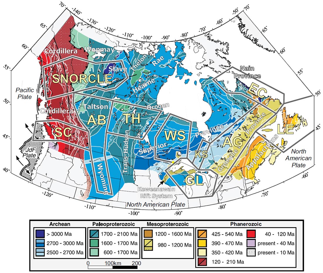
Within each transect, the scientific program is spearheaded by seismic reflection investigations. However, inclusion of all other applicable geological, geochemical and geophysical subdisciplines within the solid Earth sciences provides the scientific context that binds the program into a cohesive, comprehensive investigation. This emphasis on multidisciplinary science distinguishes LITHOPROBE from previous national programs which focused more specifically on seismic reflection profiling. Together, the ten LITHOPROBE transects represent a focused effort toward an enhanced understanding of how the North American continent has evolved to form the present Canadian landmass and offshore margins.
Some LITHOPROBE scientific results
With almost 1500 publications resulting from LITHOPROBE studies, any summary can only provide a flavor of some of those results. One unique contribution is an interpreted transcontinental lithospheric cross-section based on seismic reflection, refraction and other geoscience studies (Fig. 2). The interpretation is shown at 2:1 with the curvature of Earth properly taken into account. At this scale, readers cannot see many of the details on which the cross-section is based. During the presentation, however, some details will be shown by scrolling across the section, which also will include the seismic reflection data and refraction interpretations.
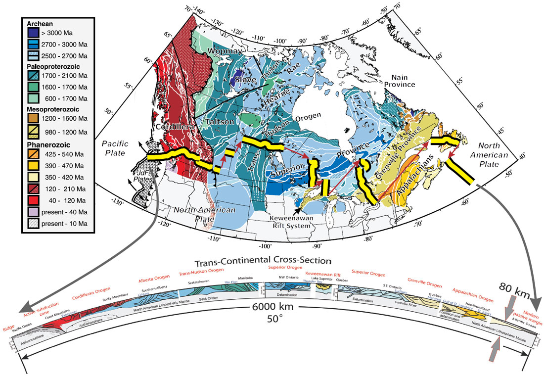
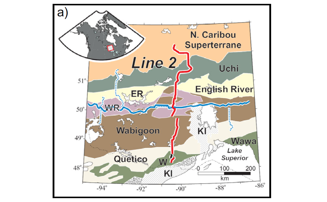
Figure 3 shows a north-south segment of the trans-continental cross-section across the Superior Province in northwestern Ontario. One of the goals of our investigations was to determine the process by which the Superior Province formed. Older blocks (> 3000 Ma), such as the North Cariboo superterrane and the Winnipeg River terrane, amalgamated through accretion and closure of intervening ocean basins. Based on geological field, geochemical and other studies, the ocean basins included island arcs and oceanic plateaus. Remnants of the accretionary processes are indicated by the sutures, mainly volcanic domains such as Uchi, Wabigoon and Wawa and the intervening metasedimentary blocks such as English River and Quetico. Extensive dating has established that the sequence of accretionary events proceeded from north to south during a period from about 2720 to 2680 Ma. The “subcreted ocean crust” is an inferred remnant of an ocean basin and the “anisotropic upper mantle” is an inferred remnant of sub-crustal oceanic lithosphere, both of which were preserved during the last stage of accretion/collision. Percival et al. (2006) provide a more comprehensive discussion. A major inference from these results and others in the Superior Province is that plate tectonic processes, as we currently understand them, were active in late Archean times, about 2800 to 2600 Ma.

An unusual feature of the CSEG 2009 Distinguished Lecture Tour is that the central scientific component of the presentation is tailored to the region in which the lecture is being given. This is possible due to the pan-Canadian aspect of LITHOPROBE and the fact that results are available from most regions of the country (Fig. 1). In the following, I focus on results from Alberta and surrounding regions. These include structures from the deep lithosphere to the (relatively) shallow Western Canada Sedimentary Basin.
In 1995, LITHOPROBE, with U.S. colleagues, carried out the Southern Alberta Refraction Experiment (SAREX) and Deep Probe, to determine lithospheric velocity structure in Alberta and U.S. states as far south as New Mexico (Henstock et al. 1998). The Canadian group focused on SAREX and Deep Probe as far south as shot point 43 in Wyoming (Fig. 4a). The profile extended across three Archean blocks (Hearne, Medicine Hat and Wyoming) separated by two enigmatic features, the Vulcan Structure and Great Falls Tectonic Zone. Two primary lithospheric features were interpreted. Approximately coincident with the U.S-Canada border, crustal thickness increased southward from about 45 km to 55 km.
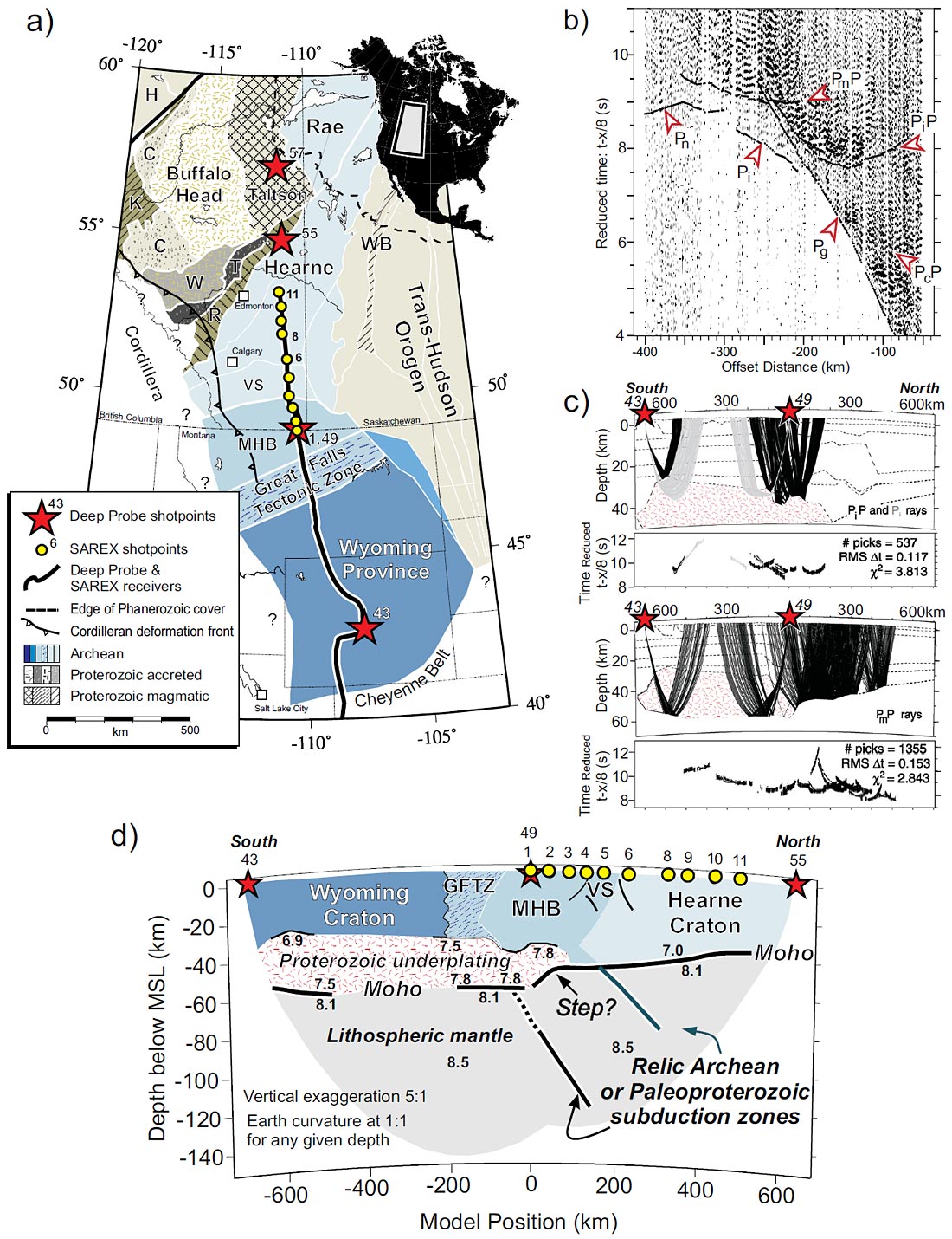
This increase in crustal thickness was due to an extensive and thick high velocity layer that was interpreted as due to Proterozoic underplating (Fig. 4d). Figs. 4b,c show a data example and aspects of the interpretation that define the underplate; turning rays within the upper part of the underplate (Pi) define velocities well and wide-angle reflections from its top (PiP) and bottom (PmP) define its geometry. From coherent secondary wide-angle reflection phases with very high apparent velocities at large offsets, two dipping reflectors within the upper mantle were interpreted (Fig. 4d). Subsequent finite-difference modeling indicated that the best time and amplitude fit occurred for reflecting slabs that were less than 5 km thick (T) with a velocity contrast (ΔV) of -0.25 to > -1.0 km/s. Based on the location of the slabs relative to the Vulcan Structure and Great Falls Tectonic Zone, the slabs have been interpreted as relic Archean or Paloproterozoic subduction zones. Clowes et al. (2002, 2009) and Gorman et al. (2002) provide a more detailed discussion.
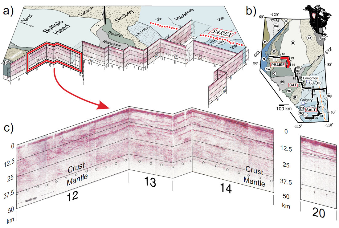
Through a series of three separate campaigns in the 1990s, LITHOPROBE, with considerable support from the petroleum industry, recorded an extensive series of reflection profiles that extended from the Peace River Arch region to southeastern Alberta and then westward toward the B.C. border (Fig. 5a,b). Ross (2002) provides a summary with extensive references. Figure 5a shows a cutaway of most of the depth-migrated sections (from Bouzidi et al. 2002) at their respective locations on a map of tectonic units of the Precambrian basement below the Western Canada Sedimentary Basin. The latter is defined by the thick band of strong reflectivity at the very top of the sections. Figure 5c shows an enlargement of these data for the segment marked in red on Figs. 5a,b. The sedimentary section is clearly defined by the bright reflectivity in the upper few kilometers. The base of the crust, or Moho, is generally distinguished in this and other segments on the basis of sharp changes in reflectivity at depths of 35-48 km (dots in Fig. 5c). Distinct reflections from the Moho are rare. In some cases, as for line 20, Moho is not defined by the reflectivity. A localized crustal thinning, about 50 km in lateral extent, is observed in the Peace River region (see western end of line 12). This thinning is consistent with an adjacent oxygen isotopic anomaly indicative of crustal extension.
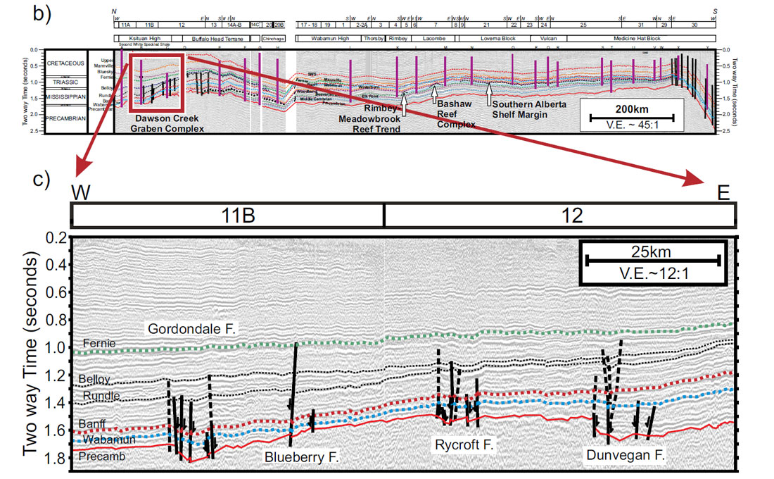
Although reflection data in the Alberta Basement transect were recorded to investigate lithospheric structure, the high quality of data acquisition provided excellent images for the sedimentary section as well. In a manner similar to the crustal section, a 1600- km-long seismic section was compiled from data along the LITHOPROBE lines (Fig. 6; see Hope et al. 1999 for a foldout section). Reflections were tied to nearby drill holes. The section enables stratigraphic horizons to be followed for hundreds of kilometers and shows varying depths and thicknesses for the different strata. The thickening of sediments toward the Cordilleran deformation front in southern Alberta is clearly seen at the southern end of the section. Figure 6c shows an enlargement of a segment of the data in which a number of faults that offset the Precambrian basement and lower sedimentary horizons are identified. One feature noted is the draping of sedimentary layers over deeper brittle detachments (Hope et al. 1999).
The LITHOPROBE legacy – Benefits to Canada and beyond
The most lasting legacy that any scientific project can have is rooted in both the quality of its scientific results and their value to humanity. LITHOPROBE results are being used to establish the architecture and tectonic evolution of the northern North American continent. This provides basic information for activities such as finding and managing resources, predicting and mitigating hazards, and establishing how Earth processes formed continents as long as three billion years ago and as recently as today. These exciting and informative results are brought to the attention of the public through an outreach strategy involving the media, educational institutions and other targeted groups.
On a pragmatic level, LITHOPROBE studies provided a focus for activities in the Canadian Earth science community for more than two decades. The quality results were the “glue” that kept the network and partnerships together; the LITHOPROBE structure was the mechanism that facilitated the essential interactions. LITHOPROBE developments and results have provided substantial contributions to Canada’s resource-based industries. For the Canadian Earth science community, and for Canada as a country, LITHOPROBE is, and has been, more than a successful scientific project: it has brought wideranging benefits to Canada. As such, Lithoprobe serves as a model for similar projects elsewhere in the world.
Regional information for industry
The new and improved understanding of Earth history in regions that are amenable to resource exploration provides petroleum and mining companies with an enhanced knowledge base from which their own more detailed exploration and development plans can be prepared. In the Western Canada Sedimentary Basin, the first continuous seismic reflection profile across the entire basin, recorded with similar state-of-the-art acquisition parameters, was compiled (Fig. 6). In a variety of mining locations associated with base metals, diamonds and uranium throughout Canada, LITHOPROBE’s studies provide a valuable framework of knowledge and understanding that otherwise would not exist.
Technological innovation and transfer of science and technology to the private sector
LITHOPROBE demonstrated the applicability of the high resolution seismic reflection (HRSR) technique to mineral exploration problems, particularly in mining regions where expensive infrastructure is already in place (e.g., Clowes 2001; Eaton et al. 2003). The successful experiments spawned a number of similar projects, usually with concurrent rock property studies. The newer projects included 3d surveys (e.g., Adam et al. 2003).
Similarly, in a collaborative study with uranium companies, LITHOPROBE showed in the early 1990s that the HRSR method could image the shallow (~ 200 m) and rugged unconformity, and features associated with it, between the metasediments of the Athabasca Basin and the underlying basement, the location of uranium deposits (Hajnal et al., 1997). In the cratonic areas of Canada, LITHOPROBE seismic and magnetotelluric studies have provided significant new information relevant to exploration for diamonds and understanding of the geology and tectonic environments within which kimberlite intrusions occur.
At a time in the mid-1980s when only a limited number of refraction seismographs existed at the GSC and some universities, yet the need for large numbers of such instruments was clear, LITHOPROBE seismologists designed a new portable refraction seismograph (PRS). GSC personnel developed and tested the instrument. The instruments were first used in LITHOPROBE refraction surveys in the southern Cordillera in 1988. The technology was transferred to Scintrex, a leading Canadian company in geophysical instrumentation. Scintrex marketed the seismographs worldwide as well as in Canada, with sales valued in the millions of dollars.
Commencing in 1980, with assistance of a $500K research grant from GSC, Phoenix Geophysics, which specializes in magnetotelluric (MT) instrumentation and contracting, developed a new generation of real-time MT equipment. GSC scientists active in LITHOPROBE worked with Phoenix, developing both hardware and software. Phoenix, with a staff of 50 in Toronto, Canada, is now the world leader in magnetotelluric instrumentation and has exported MT and related equipment and services to more than 80 countries. Exports total more than $85 million. Canada’s “return on investment” in the form of taxes alone is approximately 100:1, and the value of resources discovered with this technology is many factors greater. The success of Phoenix Geophysics and its collaboration with GSC/LITHOPROBE scientists is a testament to the role that well-targeted government financial and scientific support can play in supporting Canadian industry and jobs.
New resources and mitigation of hazards
During the 1990s, LITHOPROBE data and interpretations in the LITHOPROBE East Transect (Fig. 1) contributed to resurgence in petroleum exploration on the west coast of Newfoundland (Waldron et al. 1998; Stockmal et al. 1998), including a new discovery on the Port au Port Peninsula. However, the discovery was small and major companies abandoned their efforts but junior exploration companies continue to explore, with wells drilled as recently as July 2005.
On the west coast of Canada, LITHOPROBE studies as part of the Southern Cordillera Transect (Fig. 1) provided data and a framework for better understanding the mega-thrust earthquake hazard in the region (e.g., Clowes and Hyndman 2002). GSC scientists are continuing and extending such research, thus contributing to a much more fundamental understanding of the hazard and how it may affect the region.
In British Columbia, two transects, the Southern Cordillera and SNORCLE, generated interpreted cross sections across the Cordillera. As part of a B.C. Hydro and Power Authority project related to probabilistic seismic hazard assessment to support their dam safety program, B.C. Hydro prepared an internal report regarding the geology and seismotectonics of British Columbia and adjacent regions during the period 2007-08. Based on discussions with the author and others, and using material prepared by them, the report includes a summary interpretation of crustal structure across the northern and southern Cordillera study areas as developed through the LITHOPROBE studies.
Training the next generation of Earth scientists
One of the most significant contributions of LITHOPROBE is the involvement of young scientists — graduate students, postdoctoral fellows, research associates and assistants, and undergraduate students. Cumulatively, more than 500 young scientists learned their specific skills in an environment of stimulating, collaborative, multidisciplinary research. Through their attendance at transect workshops and special sessions on transects at national/international conferences, they were inculcated in the new paradigm of such research. Industry representatives note the importance to their companies of hiring students who are well-rounded and highly trained in a broad-based fashion to maintain their competitive edge nationally and internationally. The young scientists are a resource for Canada’s future, a pool of expertise highly trained in their specialties, but familiar with the broad-based activities of a multidisciplinary program.
Education and public awareness of science and technology
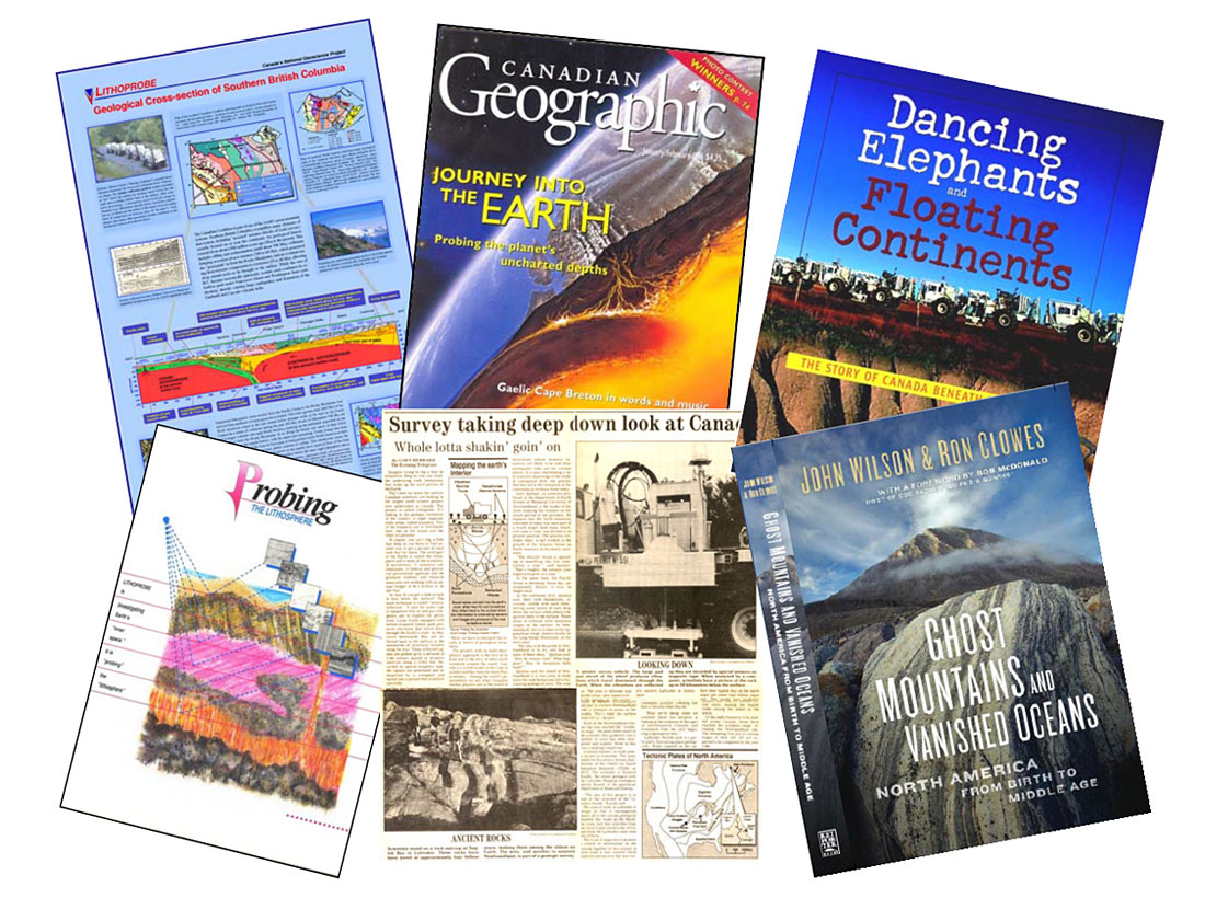
The scientific results from LITHOPROBE are informative and exciting, but complex. Communicating these results beyond the interested scientific community is important, and difficult. To achieve this communication, LITHOPROBE established a public outreach strategy; Fig. 7 illustrates some of the outcomes of that strategy. The media, both print and electronic, were used as a medium for spreading our information. One highlight was a cover article in Canadian Geographic (Fig. 7). Overall, more than 250 media articles on LITHOPROBE have been catalogued. Direct targeting of different groups; e.g., high school and university students through their teachers, federal and provincial political leaders, petroleum and mining industry representatives, the broader Earth science community and the interested public was only partially successful. LITHOPROBE prepared a full color brochure, Probing the Lithosphere (in English; Fig. 7) and Sonder la lithosphère (in French), which included a 6-page folded cover and an 8-page insert. Overall, more than 25,000 copies of the brochure were distributed. A poster, Geological Cross Section of Southern British Columbia (Fig. 7), was developed and distributed widely (about 2500 copies) at no charge. A children’s book, based on LITHOPROBE results, that is intended for mid-grade students (ages 10-14) was authored by John Wilson (Fig. 7). Noting the value of such a book for educational purposes, LITHOPROBE contracted the preparation of Teachers’ Companion Material, to encourage use of the children’s book in the educational system. This teachers’ material is downloadable at no cost from the LITHOPROBE web site. A new book based on LITHOPROBE results and intended for the interested adult public has been written by John Wilson and Ron Clowes (Fig. 7); the publisher’s release date is April 2009. The LITHOPROBE web site, www.lithoprobe.ca, remains an active source of information for education and public awareness.
A new approach to collaborative Earth science in Canada
The LITHOPROBE research network redefined the nature of much Earth science research in Canada. It successfully fostered an unprecedented degree of cooperation among Earth scientists in universities, federal and provincial/territorial geological surveys, and the mining and petroleum industries. It spawned a new and healthy atmosphere of scientific cooperation among geologists, geophysicists, and geochemists who are working and learning together, thereby enhancing results beyond those that could be achieved through any one subdiscipline. LITHOPROBE literally changed the face of Earth science research in Canada.

Acknowledgements
LITHOPROBE was funded on a sustaining basis from 1984 to 2005 by the Natural Sciences and Engineering Research Council of Canada through the Research Networks Element of the Research Partnerships Program (and earlier equivalent programs) and by the Geological Survey of Canada. Additional funding and support were provided by significant industry involvement and provincial/territorial geological surveys when studies were within their areas of jurisdiction or interest. Preparation of this article was supported by an NSERC Discovery grant to the author. LITHOPROBE publication no. 1478.
Related Reading


Join the Conversation
Interested in starting, or contributing to a conversation about an article or issue of the RECORDER? Join our CSEG LinkedIn Group.
Share This Article