Introduction
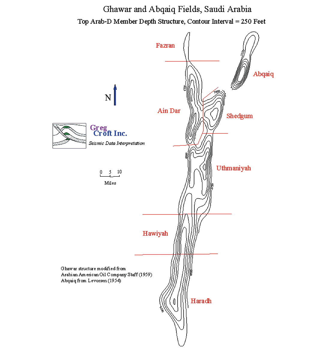
The Ghawar Oil Field is by far the largest conventional oil field in the world and accounts for more than half of the cumulative oil production of Saudi Arabia. Although it is a single field, it is divided into six areas. From north to south, they are Fazran, Ain Dar, Shedgum, Uthmaniyah, Haradh and Hawiyah. Although Arab-C, Hanifa and Fadhili reservoirs are also present in parts of the field, the Arab-D reservoir accounts for nearly all of the reserves and production.
The Ghawar Field was discovered in 1948. Production began in 1951 and reached a peak of 5.7 million barrels per day in 1981. This is the highest sustained oil production rate achieved by any single oil field in world history. At the time that this record was achieved, the southern areas of Hawiyah and Haradh had not yet been fully developed. Production was restrained after 1981 for market reasons, but Ghawar remained the most important oil field in the world. The production of the Samotlor Field in Russia was greater during the mid-eighties, but this was because production at Ghawar was restrained. Development of the southern Hawiyah and Haradh areas during 1994 to 1996 allowed production from the Ghawar Field to exceed 5 million barrels per day once again, more than Samotlor ever produced.
Information about The Ghawar Oil Field
This remarkable production history is because of the enormous size of the Arab-D reservoir in the Ghawar Field. Alsharhan and Kendall (1986) provide a figure of 693,000 acres (2804 km2) for the productive area of the Ghawar Field. This re p resents a single, pressure-continuous reservoir. Cumulative production by the end of 2000 was about 51 billion barrels of oil.
The anhydrite in the Upper Arab-D forms the seal for the 1,300 foot (396 m) oil column in Ghawar. It is composed of sabkha evaporites and subaqueous evaporites with thin carbonate interbeds that can be traced for hundreds of kilometers. The anhydrite thickens to the south at the expense of the reservoir zones while the combined thickness remains relatively constant.
The Arab-D reservoir at Ghawar comprises two major shoaling-upward cycles deposited during a relative highstand in sea level (Mitchell et al, 1988). It is composed of skeletal grainstones and packstones with ooid grainstones locally common in the upper Arab-D. The diagenetic processes that have affected the Arab-D reservoir include dolomitization, leaching and recrystallization, cementation, compaction and fracturing.
Interparticle porosity is abundant in the Arab-D reservoir in the Ghawar Field and moldic porosity is also common. Intercrystal pores are common in dolomites and microporosity is abundant in both limestone and dolomite lithologies.
In the uppermost part of the Arab-D are occasional zones that contain more than 10% of a stromatoporoid sponge known as cladocoropsis. Where this facies is dolomitized, the relatively fine-grained matrix is replaced by dolomite and the cladocoropsis is leached, causing a phenomenon described by reservoir engineers as super- permeability. These superpermeable zones, where present, offer so little resistance to fluid flow as to be difficult to model for reservoir engineering purposes.
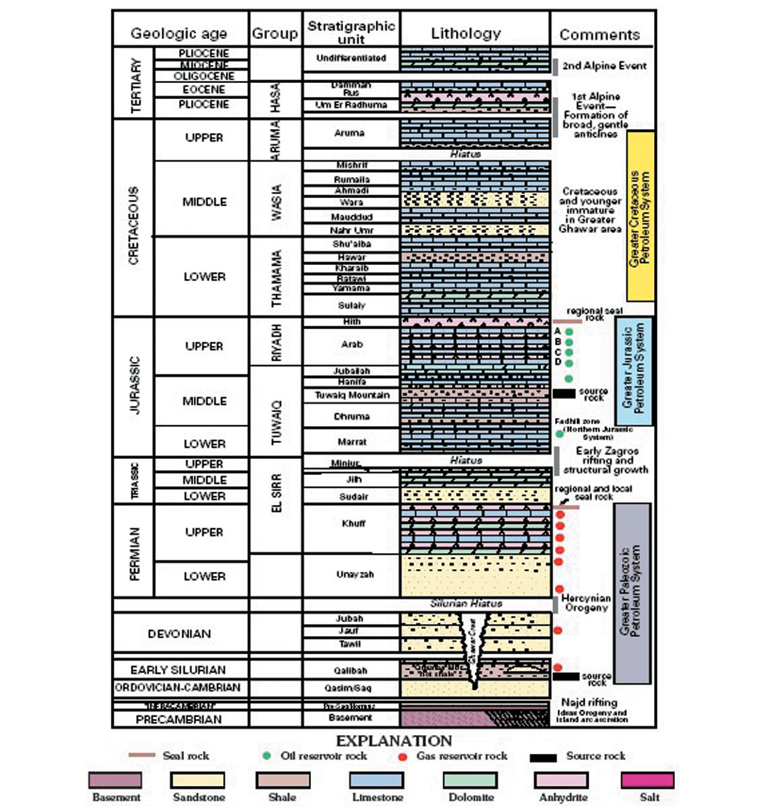
The source rock for the Ghawar oil is believed to be the Tuwaiq Mountain Formation, which underlies the Hanifa. It is Callovian and Oxfordian in age and reaches a thickness of more than 300 feet (90 m) in the basinal area between the Ghawar and Khurais Fields. That this moderate volume of source rock should produce the largest accumulation of light oil in the world indicates very efficient migration and entrapment. The fact that the Ghawar oil-water contact is substantially higher on the west flank than on the east indicates a hydrodynamic gradient to the east, which may explain the much larger volume of oil in Ghawar than in Khurais.
The Ghawar structure consists of two subparallel, north-south trending structural crests, separated by a saddle. It is about 174 miles (280 km) long and 12 miles (19 km) wide. In the northern part of the field, the saddle dips below the initial oil-water contact between Uthmaniya and Ain Dar, but the two crests remain above it. The Fazran and Ain Dar areas are along the western crest and the Shedgum area is along the eastern crest. The three southern areas extend across both crests. These crests existed at the time of Arab-D deposition and the reservoir quality is best in the crestal areas. A map of the Ghawar structure at Arab-D level in shown in Figure 1.
The oil-water contact at Ghawar dips to the northeast, dipping more than 660 feet (200 m) between the southwest end of Haradh and the Fazran area. The contact is consistently higher on the west flank of the field than on the east, and a tar mat is associated with the original contact. Water injection wells are completed above this tar mat for pressure maintenance.
This peripheral waterflood project began in the early sixties in the northern parts of the field. By the time that the southern Hawiyah and Haradh areas were developed during 1994 to 1996, horizontal-drilling technology was available. Horizontal injectors were completed above the tar mat to provide line source distribution of water along the periphery of the field.
Description of Ghawar Oil Field Reservoirs
Primary reservoirs are sandstones of the Permian Unayzah and Devonian Jauf formations in the Central Arabia Qusaiba-Paleozoic total petroleum system (TPS), and basal transgressive marine sandstones and cyclic dolomitic shelf carbonates of the Late Permian Khuff Formation in the Gulf portion of the TPS. Other reservoirs include clastics of the Pre-Qusaiba section that are fault bounded and sourced laterally by the down-faulted Qusaiba Shale Member. These Pre-Qusaiba clastic reservoirs include the Cambrian-Ordovician Saq Sandstone, shallow-marine sandstones of the Ordovician Qasim Formation (Senalp and Al-Duaiji, 2001), and Upper Ordovician glacial and periglacial clastics of the Zarqu and Sarah Formations (McGillivray and Husseini, 1992). Many of these Pre-Qusaiba clastics have had some hydrocarbon shows but are poor-quality reservoirs owing to silica cementation.
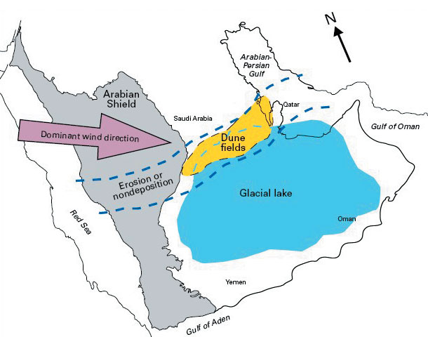
The Upper Permian Unayzah Formation is a complex succession of generally red continental clastics consisting of braided-plain, channel-fill, and eolian sand and flood-plain silt that were deposited on the pre-Unayzah (Hercynian) unconformity (Senalp and Al-Duaiji, 1995; Evans and others, 1997; Konert and others, 2001). Regional surface and subsurface data indicate that the Unayzah is widespread over much of the eastern Arabian Plate (Al-Laboun, 1987). A recent study by Heine (in press) showed that sandstones of the Unayzah in the southern Ghawar area are cold-climate (periglacial) dunes deposited on an eroded surface that trends across central Saudi Arabia, and possibly over Bahrain and Qatar.
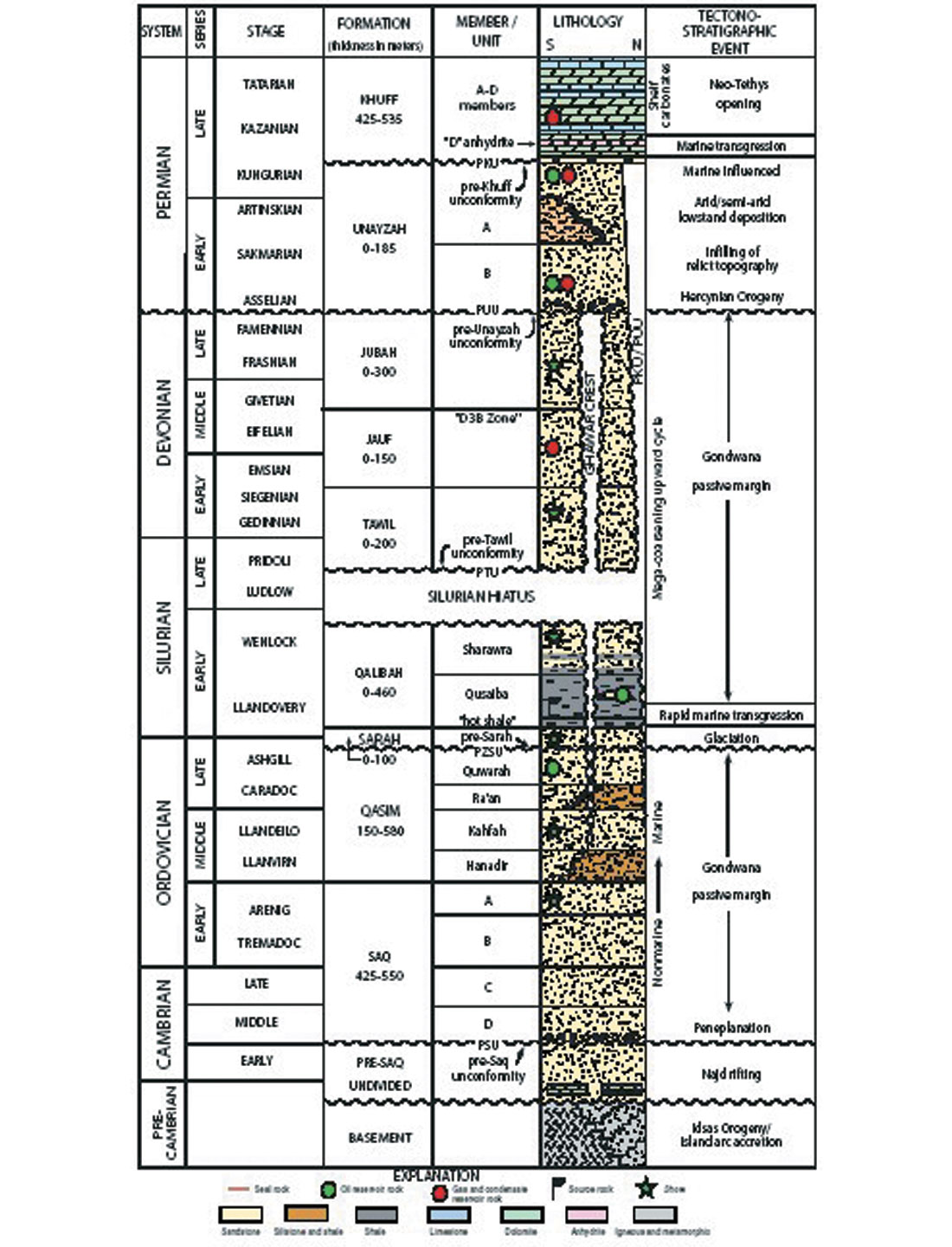
The Unayzah unconformably underlies the Upper Permian Khuff Formation. Deposition of continental clastics of the Unayzah re p resents a major change in sedimentation that preceded a major marine transgression and widespread deposition of carbonates and evaporites of the Khuff Formation. The Unayzah Formation is composed of cycles of crossbedded, fine-to coarse-grained sandstones, siltstones, and claystones with thin beds of argillaceous limestone. In central Saudi Arabia, the lowermost part of the Unayzah consists of debris-flow gravels and coarse clastics, which infill the Hercynian erosional unconformity on the underlying Qusaiba Shale (Senalp and Al-Duaiji, 1995). The Unayzah Formation fines upward into more distal, braided-stream bars and channel-fill sandstones, and flood-plain siltstones. The cyclic nature of the Unayzah suggests a fluctuating sea level. The upper Unayzah unit A is the principal reservoir, averaging about 20 percent porosity. Permeability of several darcies is not uncommon; however, both porosity and permeability vary due to kaolinite and illite cements (McGillivray and Husseini, 1992).
In the Greater Ghawar area, the principal Pre-Khuff hydrocarbon reservoir in the southern area (Haradh substructure field at Ghawar, and adjacent Sahba, Waqr, and Tinat fields) is the Unayzah Formation, whereas the Lower to Middle Devonian Jauf Formation is the main producing reservoir in the northern Ghawar area (Ghawar substructure fields: Hawiyah, Uthmaniyah, and Shedgum). In the south Ghawar area, the Unayzah is generally divided into two sandstone reservoir units separated by a siltstone member (Wender and others, 1998). Gas is produced from most Paleozoic reservoirs at Ghawar; however, Qusaiba-sourced premium crude is produced from the Unayzah at the Tinat field structure immediately to the southeast. The Unayzah is missing in the north half of Ghawar field (McGillivray, 1994) but is present in the south half of Ghawar, where it thickens from 0 to greater than 152 m at Tinat field. Porosity of the upper Unayzah-A pay zone ranges from 5 to 25 percent and averages about 12 percent (Wender and others, 1998).
The shallow marine sandstones of the Devonian Jauf reservoir in the Ghawar area are well developed and commonly display high (30 percent) porosities at a depth of 4,260 m. In the northern Ghawar area, the Jauf reservoir ranges in thickness from 89 to 145 m. The giant gas-condensate discovery at the Hawiyah substructure field at Ghawar is in Jauf sands. These Jauf sandstones are fine to medium grained, are weakly cemented by authigenic illite clay, and lack the silica cement that is prevalent and detrimental to reservoir quality of most other Pre-Khuff sandstones. The authigenic illite is thought to inhibit quartz cementation and to preserve porosity. At Ghawar field, and at Abu Sa’fah field in the offshore to the northeast of Ghawar, the Jauf reservoir is sealed by a distinctive shale-silt layer that is referred to informally as the D3B zone (Wender and others, 1998). The Late Permian-Early Triassic Khuff Formation unconformably overlies the Unayzah Formation. Gas was discovered in carbonate rock reservoirs of the Khuff in the Awali field domal structure of Bahrain in 1949. The Khuff Formation is ranked as the largest reservoir formation of non-associated gas in the world with recoverable reserves estimated at about 750 TCF (Konert and others, 2001). Khuff reserves include the largest gas field in the world at North dome (field), Qatar, discovered in 1971; its total reserves are estimated at 500 TCF (Alsharhan and Nairn, 1997). The Khuff Formation produces primarily gas that probably formed by the cracking of oil (Bishop, 1995). Locally, the quality of Khuff gas depends upon the amounts of non-hydrocarbon gases, mainly H2S, CO2, and N2. The amount of H2S increases with increasing temperature and depth, reflecting in-place conversion of hydrocarbon gases to H2S by the thermochemical reduction of anhydrite sulphate (Konert and others, 2001).
In eastern Saudi Arabia, the Khuff Formation is divided into five units or members designated as Khuff A through E. However, throughout the Gulf region the Khuff may comprise as many as seven designated units or members (Al-Jallal, 1995). Most of the Khuff is composed of carbonates and evaporates; major siliciclastic facies increase towards the west. As many as four of the five units may be reservoirs and correspond to four depositional carbonate-anhydrite cycles where transgressive carbonate rocks are capped by regressive anhydrite facies. The Khuff Formation thickens from about 260 m in southwestern Saudi Arabia to more than 915 m in the central Rub ‘al Khali Basin, 1,220 m in Oman.


Join the Conversation
Interested in starting, or contributing to a conversation about an article or issue of the RECORDER? Join our CSEG LinkedIn Group.
Share This Article