Introduction
Over the last 25 years, geophysical analysis of seismic data has greatly evolved. However, in the routine utilization and daily workflows of many exploration and development teams, geophysical technology is at a standstill. This paper came though our observations and dealings with many geophysicists over time. We’ve been involved with geophysical technology for over 20 years and we’re amazed that after all these years many people are still relying of basic seismic interpretation methods – time structure and amplitude maps. Except a select few, geophysicists do not usually delve into the world of seismic attribute analysis.
Seismic Attribute Analysis can be clustered into distinct topics or headings. These geophysical “innovations” provide an evolutionary road map of geophysical analysis from amplitudes to fluids to rock properties to geomechanics.
We should state now that this is not an all encompassing article. It is based on our perception of the current state and direction of exploration geophysics. The technologies and people we reference is not an end-all list and we apologize in advance for those we do not mention. It is not our intent to ignore or trivialize other people’s work.
The purpose of this paper is to review a few of the major milestones of geophysical innovation. The aim is to provide insight into how geophysics has evolved and provide a glimpse into the direction the science and its application is going. With the advent of exploration for unconventional reservoirs, there is a perception that the need for geophysics will decline. On the contrary, it appears that the need for more detailed multidisciplinary investigations will only increase over time.
In school we – geologists, engineers, and geophysicists – learned how reflectivity equations provide us with the basics for what is needed to interpret seismic data. It gives us an understanding of the time required for a seismic impulse to travel to and through a reservoir. It also gives us some understanding of the amplitude we should expect to record by way of acoustic impedance properties encountered by the traveling seismic wave.
This has been the status quo for more than 40 years. Seismic amplitudes were revolutionary in the 1960’s (see e.g. Schneider, 1971). Many exploration teams still rely solely on time structure and horizon amplitude maps to present their exploration prospects to management or drilling engineers.
Typically an exploration team evaluates a play for three primary conditions: charge, trap and seal. However, eventually, someone will ask about Reservoir. The seismic signal is comprised of three attributes – Amplitude, Phase and Frequency. Each one reveals different nuance to the reflected geologic image. Seismic Attribute Analysis investigates these responses in an effort to provide greater insight to a reservoir’s characteristics. It is different than traditional seismic mapping. Now there are hundreds of seismic attributes out there. Most are post-stack, are closely related and easily generated by today’s workstation.
Pre-stack seismic attribute analysis is more involved, but it is this evaluation that is providing the greatest insight to rock physics and by extension, a greater understanding to developing unconventional reservoirs.
Innovations in Geophysical Analysis
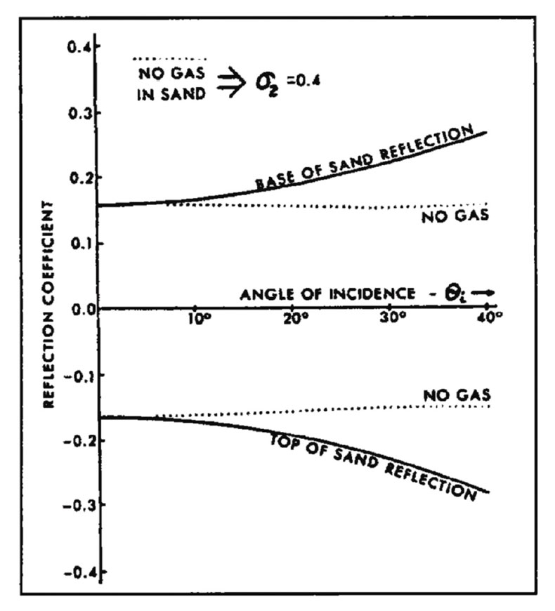
The first innovation came through the simplification of the work of Zoeppritz (1919) by Aki and Richards (1980) and particularly by Shuey (1985). At the same time, Ostrander (1982) observed that seismic amplitudes changed with angle of incidence in the presence of gas (Figure 1). The Zoeppritz equations provide an explanation for this effect, especially through the use of the simplifications introduced by Aki and Richards and Shuey, which resulted in solvable linearized equations, allowing us to easily estimate shear-wave properties in addition to acoustic impedance for the first time.
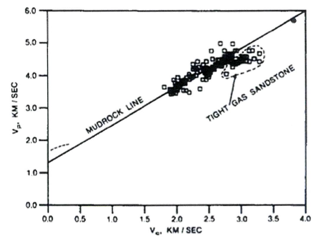
Castagna et al (1985) started to quantify this effect with their development of the “Mudrock Line” (Figure 2). This effect was further quantified with the “Fluid Factor” of Smith and Gidlow (1987). The importance of this innovation was the ability to evaluate fluid properties using seismic data.
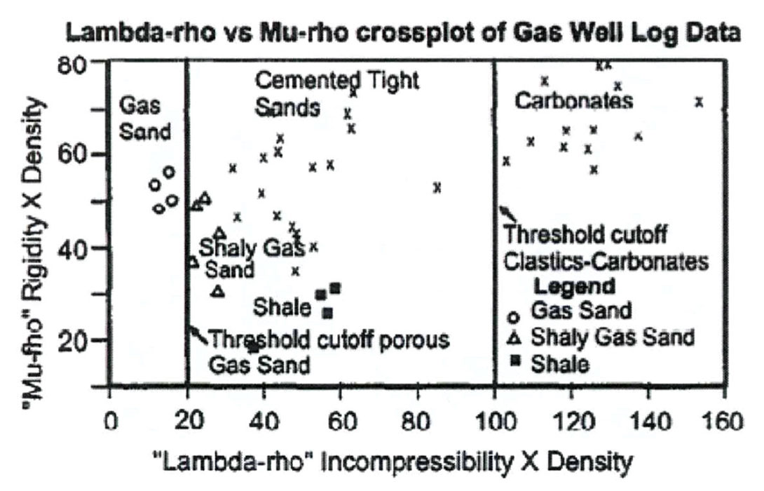
With seismic being acquired with longer and longer offsets, evaluation methods began to focus on angles and the shear wave component to the seismic ray path came under scrutiny. This brought rock physics into play – the next great innovation. Backus et al (1993) describe the incorporation of petrophysics and borehole properties into seismic interpretation. A further extension of this was the work by Goodway et al (1997) who incorporated these principles with their paper on rock properties – Lambda-Mu-Rho (LMR). This innovation provided for more direct estimation of lithologies and fluids from seismic data using petrophysical parameters (Figure 3).
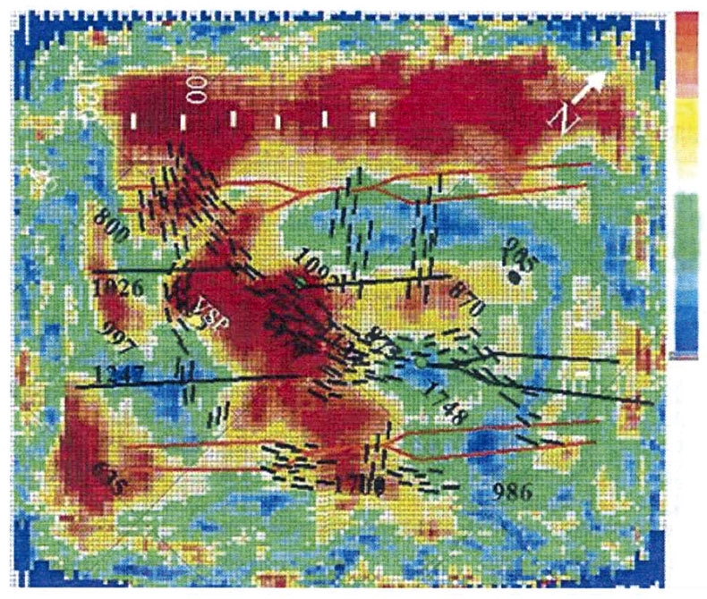
Thomsen (1985) simplified the concept of seismic anisotropy, the variation of physical properties in different directions, by introducing the concept of weak anisotropy. Lynn et al (1996) showed that these effects could be seen in seismic data and Gray et al (1999) showed that fractures could be detected using 3D wideazimuth seismic data– the next innovation. This was done, once again, by examining the shear wave component of the seismic response, which is affected differently depending whether it is traveling parallel or perpendicular to the fracture system due to its anisotropy (Figure 4). The impact of this was that engineering decisions could now influenced directly by seismic recordings.
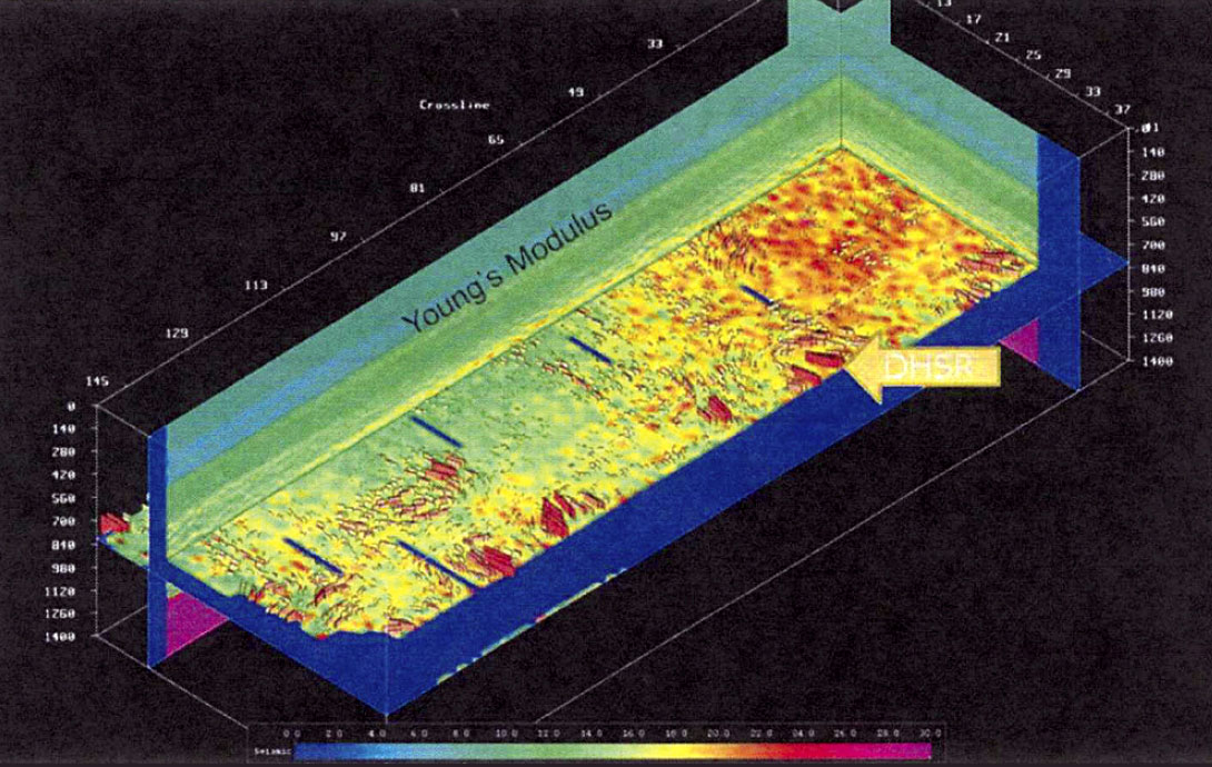
So where are we now? By incorporating the concepts of stress and stain into the anisotropic calculations, we are now deducing Geomechanical properties from seismic data (Figure 5). Stresses, Young’s modulus and Poisson’s ratio, although present in geophysical algorithms for years for fluid calculations, they are also parameters the engineering teams use for well planning and fracking. Young’s modulus can be used as a proxy for brittleness. We are now talking in terms of what a drilling engineer uses. Delivering an amplitude map with 100 milliseconds of closure is of little value in unconventional exploration.
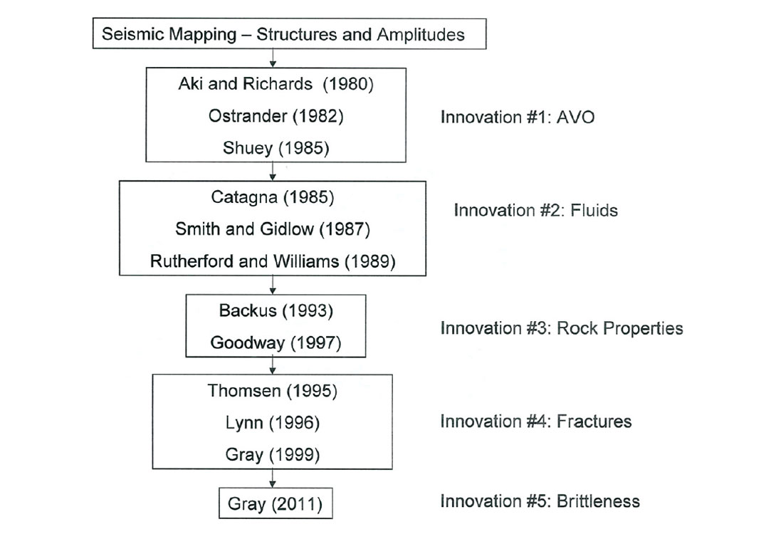
Modern geophysicists should consider themselves a partner in the drilling and development of the field. Through a series of innovations (Figure 6), we are no longer just producing structural maps with stacked amplitude conformance. We now have the capability of providing key links between geology and engineering through the use of geomechanical insights gained from seismic data. Expensive drilling decisions can be influenced in a positive way with the use of these seismic techniques.
The New Asset Team
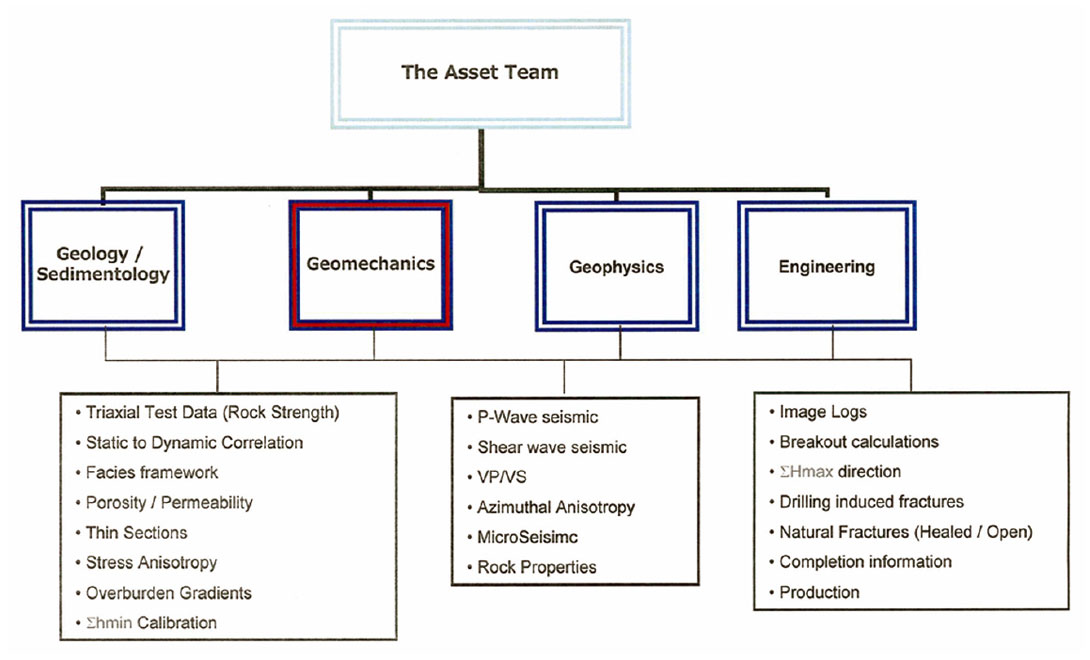
The repercussion of these innovations is that the conventional asset team is changing. Historically, they were made up of a Geologist, a Geophysicist and an Engineer. There is a new disciple emerging: Geomechanics. Borehole stability, casing design, lateral well spacing, pore pressure, stimulated reservoir volume, and cap-rock integrity are just a few of the roles of this team when exploring for either unconventional resources or exploration wells in extreme locations like deep water or over pressured regions.
Whether it is an individual or knowledge of the science, Geomechanics is emerging to be the glue that links cross-discipline analysis. Figure 7 shows that the new asset team must share information to be successful. The geologist’s thin sections and core analysis, coupled with the engineer’s completion and borehole data, provides validation to the geophysicist’s anisotropy and rock property studies.
Historically, wells were drilled “on target, on depth and on budget”, only to find that the reservoir was not conducive to producing in the direction it was drilled and fracked. Once a template is formed, sound drilling and business solutions can be developed that are based on rigorous multidisciplinary investigations. A 100 ton frack at 200m perf spacing has much different economics that a 200 ton fack at 100m perf spacing.
Conclusion
Exploring for the unconventional is not the same as exploring for conventional resources. Geomechanics drives shale and oilsand development and will be required to assure the success of wells costing in the tens – hundreds of millions of dollars. Amplitudes and structures do not. Geophysical methods are the only laterally extensive method that we have to not only gauge our exploitation impact on these reservoirs, but to potentially understand the nature of the reservoir and geomechanical properties prior to drilling.
Geophysicists and Geologists must communicate with the Engineers in terms they understand. Young’s modulus, Poisson’s ratio, stresses, and pore pressures are used for stimulation modeling and completion optimization. Stimulated Reservoir Volume (SRV) is a poorly understood concept in tight reservoirs and greatly impacts production projections. Geophysics has the potential to facilitate SRV estimation.
Environmental concerns needs to addressed. Geomechanical information on the overburden, derived from seismic, is an important element to investigating the environmental concerns related to fracking such as caprock integrity and ensuring the safety of our drinking water.
Finally, in order to be successful, there is a need to develop a new style of asset team where geomechanical information is shared and incorporated across all disciplines – Geology, Geophysics, Engineering and Geomechanics.
So to answer those that believe that the need for geophysics in an E&P company is dwindling and becoming obsolete, we must state that we cannot disagree more. The evolution of geophysics from Amplitudes to Geomechanics has provided a detailed understanding of rock physics that is providing insights and drilling solutions that have never been available before.

Acknowledgements
We would like to recogize Kurt Wikel and Geoff Rait for their continuous patience for teaching us the finer details of geomechanics.




Join the Conversation
Interested in starting, or contributing to a conversation about an article or issue of the RECORDER? Join our CSEG LinkedIn Group.
Share This Article