Introduction
Very high quality gravity surveys have been carried out for nearly half a century now. I have personally seen small gravity survey results from the late 1940's which rival present day quality. The main reason for this lies in the care with which these surveys were acquired. It took considerable time and skill to do a good gravity survey because the instrumentation, although excellent for that time, was rather problematic to work with.
Gravity meters were improved over time, but up to the mid-l980' s all gravity meters were based on very precise and highly sensitive mechanical design principles. Such gravity meters measured the displacement of a mass attached to a zero length spring, and a calibrated measuring screw changed the tension of this spring to return the mass to the calibrated center (zero) point. From the perspective of physics, gravity measurements are very straight forward; however, to effect accurate gravity measurements in survey conditions calls for a sensitive and complex instrument as well as a reasonably well trained and conscientious operator. Standard mechanical gravity meters are still used very widely, and if calibrated, handled and operated properly, the results from such surveys are generally acceptable. Mechanical meters are very prone to "tares", which are zero point offsets in the meter induced by mechanical or thermal shock. The quality of individual meters of the same model varies widely, with some being excellent while others are rather poor. The reason is usually the condition of the zero length spring and the quality of the instrument temperature compensation. Excellent instrument internal temperature stabilization and gentle handling are crucial for standard gravity meters to assure reliable and low drift data acquisition.
Electronic Gravity Meters
The availability of fully electronic gravity meters since the late 1980's represents a major improvement in instrument technology and now allows for much higher accuracy in data acquisition. Although instruments with a resolution of 0.001 mgal are available, a 0.01 mgal resolution is quite sufficient for most exploration purposes.
The gravity measurement system in electronic gravity meters has no "moving" parts. The sensor functions much like a vertical accelerometer, whereby the sensing mass is usually a minute quartz crystal mounted in the form of a micro capacitor. The design allows for much greater shock resistance, is immune to "tares" and provides for a 7,000 mgal measuring range without any calibration changes.
Temperature compensation and stabilization in these new meters are of even greater importance than in standard meters, as even micro-degree changes lead to noticeable accuracy deterioration. These matters have been taken care of in the design by placing the sensor element in a highly vacuumed enclosure with very sophisticated and precise temperature control electronics. Instrument levelling is based on horizontal inclinometer readings and internal feed back electronics allow for tilt self corrections to assure a reading accuracy identical to ideal for a range of up to +/- 150 arc seconds.
In contrast to the single operator observation with a standard meter, the gravity measurement with the electronic meters consists of a 'stack' of usually 60 individual readings.
When the instrument is properly calibrated, a built in auto drift correction minimizes meter drift to almost nil over a period of days. The repeatability of readings is amazing. Personal experience has shown actual survey repeats of no worse than 0.02 mgal over a seven month period. All gravity readings, along with observation parameters, drift, and earth tide corrections are stored digitally in the instrument, ready for extraction into any PC for processing and data reduction.
Gravity Station Surveying
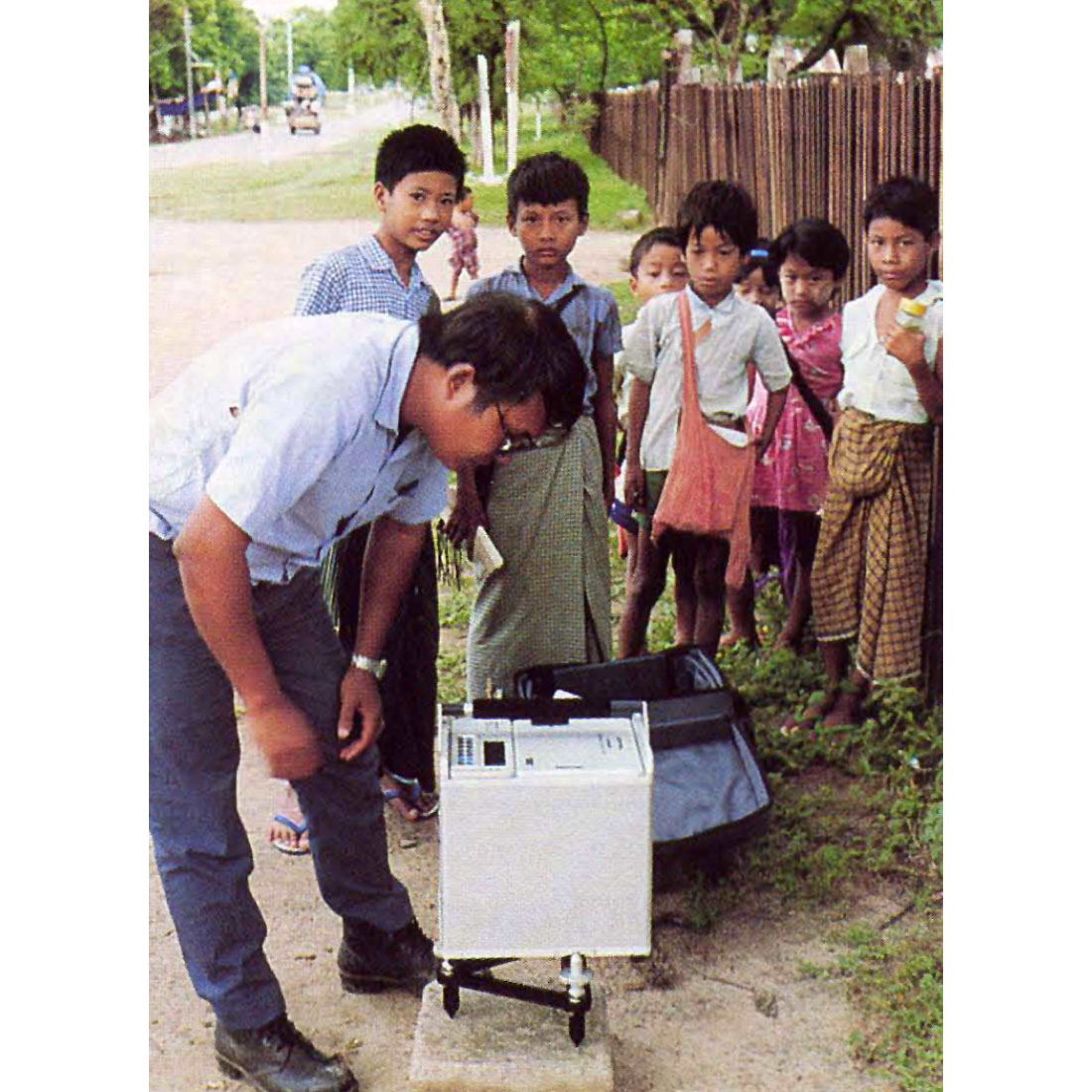
A highly accurate station location and especially elevation survey is crucial to the quality of any gravity survey. The importance of the station elevation accuracy is easily understood when one considers the rule of thumb correlation between observed gravity and elevation change. A mere 3 cm elevation difference makes for a 0.01 mgal observed gravity reading difference. Conventional surveying provides for very high accuracies, but, it can also become one of the major cost components of a gravity survey. GPS (satellite based global positioning) has been of limited use to date in gravity surveys because of accuracy and/or time constraints to obtain readings at the required accuracy level. However, with the arrival of high quality, light weight receivers last year, gravity station positioning can be carried out now to centimeter accuracy (usually in real time differential mode) with GPS alone.
Terrain Corrections
The gravity method is principally suited for exploration applications in a structural geological environment, which means that gravity surveys have to be frequently conducted in rough topographic environments. This also brings about additional complexities which have to be overcome in order to make full use of the high accuracy of the gravity readings. Fortunately, station elevation accuracy can now be more quickly and reliably assured with modern GPS receivers than with conventional survey techniques.
At the same time, horizontal gravitational forces influencing the meter readings in highly variable terrain need to be addressed and corrected for as precisely as possible. Normal land gravity acquisition involves the estimation of "inner zone" terrain corrections by the operator for each gravity station. What this means is that the mass volume surrounding a particular gravity point above and below the station location has to be estimated and calculated. The correction is then applied in the processing and added to compensate for the decrease in the measured vertical gravitational force.
The inner zone correction estimation and calculation is quite crucial for the overall accuracy of each gravity reading. It is of little use to have a reading accuracy of 0.01 mgal or better when the terrain correction estimation errors are in the 0.2 mgal range or worse. This can happen quite easily because of basic estimation errors or limitation of visual range. Inner zone terrain correction estimation errors can be greatly reduced with ground reflecting laser distance and angle measurements. However, for conventional land gravity surveys in rough terrain, the line of sight is usually the limiting factor for the overall accuracy of the estimation/measurement. Major improvements for the determination of outer zone terrain corrections are feasible now with the availability of digital terrain data. Details about outer zone terrain corrections will be provided in Part 3 of this series.
Long Line Gravity
Helicopter borne "long line" gravity surveys have been used selectively for nearly two decades in areas of poor access and/or poor surface conditions. Long line gravity is not to be mistaken for airborne gravity, which has been quite aggressively marketed for a number of years, but so far is of no use to exploration because of lack of resolution and accuracy. In the "long line" approach, the gravity meter, enclosed in an appropriate shell, is towed by the helicopter on a 50 meter long cable. For each gravity reading the meter is lowered to the ground, much like for a conventional land survey gravity reading. Meter levelling is done via remote control from the helicopter. The gravity reading is also taken remotely by the operator in the helicopter and stored in the instrument memory or on disk by a PC in the helicopter. The quality of the long line gravity reading itself is identical to that of a good ground survey reading.
Using the latest available improvements in positioning technology with GPS and ground reflecting laser technology, gravity data acquisition accuracy by means of the long line approach has become superior to conventional land gravity data acquisition. GPS positioning on ground can become difficult or impossible in dense bush or high tree cover, and especially in terrain which provides for high signal cut off angles. Except for extreme slope conditions, these problems are eliminated in helicopter borne GPS positioning.
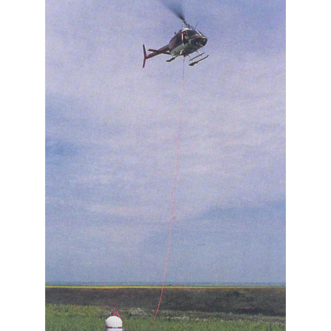
In the long line approach, the station elevation is determined from the measured GPS XYZ position at the helicopter and a simultaneous vertical laser distance measurement to the gravity meter. The positioning and station elevation result is generally as good as a conventional one taken on surface at the gravity meter. Ground reflecting laser provides a big additional advantage, as it can be used accurately to scan the terrain surrounding the gravity meter for inner zone terrain correction information. Viewing angle limitations for inner zone correction measurement information are mostly eliminated by the height of the helicopter above surface. Highly accurate gravity readings combined with best possible inner zone terrain correction information/ measurements improve the overall survey accuracy substantially.
Conclusions
Digital gravity meters, most recent advances in GPS technology and ground reflecting lasers can be combined to provide for significant improvements in reliability, accuracy and efficiency in new gravity surveys. The refinement in overall survey quality is most obvious for gravity surveys in problematic acquisition environments, but it is also of great benefit for more standard regional and detail gravity exploration and allow for much more detailed and reliable interpretation results.
Gravity surveys can serve as a very cost effective exploration tool in several ways, even in a "mature" exploration environment such as the Western Canada Basin. The targets must be of a structural nature and at a depth which generally should not exceed 2000 meters. The principal application of gravity surveys lies in high grading potential exploration areas prior to detailed seismic exploration. Also, gravity surveys carried out in conjunction with seismic surveys, especially in the Foothills environment, can provide for substantial additional exploration information at very reasonable cost. High quality gravity surveys generally allow for a good delineation of reef trends and quite often even individual reefs, provided the density differential is reasonable and the target size is greater than 500 m diameter at a depth of no more than 1800 meters.

Related Reading


Join the Conversation
Interested in starting, or contributing to a conversation about an article or issue of the RECORDER? Join our CSEG LinkedIn Group.
Share This Article