When asked to prepare a personal memoir, I must admit I had reservations. I recalled many of my contemporaries who had wonderfully inspiring career experiences that easily would surpass mine. I can only hope that mine possibly will give inspiration to some.
–Norman Domenico
Early years in academia
A common acknowledgment when reviewing professional experiences and achievements is “I stood on the shoulders of giants”. This applies in my case. Following two years in the Naval Air Force (long ago becoming part of the U.S. Air Force) I returned to the Colorado School of Mines in 1946 to finish two years of undergraduate studies in geophysics.. At that time Professor C.A. Heiland was teaching undergraduate courses in exploration geophysics. Educated and commencing a career in exploration geophysics in Germany, he immigrated to the U.S. many years earlier. It was my first experience with what I considered, perhaps wrongly, to be a European style of lecturing. No questions please and the professor exits the classroom first at the bell. Heiland was such an excellent, comprehensive lecturer that there was no need for questions if one listened closely. Later in graduate school at the California Institute of Technology I had the good fortune of being a student of Professors C.H. Dix, C.F. Richter, and B. Gutenberg. Of course there also were many other excellent instructors contributing to a wonderful, exciting education.
A respite
In the summer of 1948, following completion of undergraduate studies at CSM, I had the good fortune of acquiring summer employment as a trainee on an Atlantic Refining Co. seismic field party in the Wyoming Wind River Indian Reservation. Myself and two other trainees were assigned in rotation as driller, recorder (including seismometer (“jug”) placement), and surveyor helpers. This was a welcome respite after the confines of classrooms and was a good indoctrination in seismic field practices. Several other oil and geophysical companies offered summer trainee positions. Hopefully, all of us earned our keep. There were, of course, unexpected and sometimes hazardous experiences. Personally, I recall nearly backing a water truck off of a mountain road!
Back to academia
In the fall of 1948 I enrolled in geophysical graduate studies at Caltech. These included field trips and surveys. Among the latter was a gravity survey in Pasadena and a gravity traverse across the San Andreas fault through the town of Mojave. In Pasadena on almost every street intersection the elevation and geographical position are etched in the curbing. The only remaining task is the gravimeter reading. One problem: traffic. I soon learned that the optimum time for the survey was Sunday morning when traffic was a minimum. With the gravimeter in a Caltech jeep, on several Sunday mornings I traveled sidewalks (illegally?), stopping at corners for readings. The configuration of igneous bedrock was shown clearly. I was equally fortunate in the Mojave desert for the San Andreas Fault gravity profile. A main highway along a railroad crossed the Fault nearly perpendicularly. Along a railway service road are benchmarks, at one-quarter mile intervals, giving elevation and geographical position. The purpose of these is to monitor fault movement. How convenient for gravity readings! One problem. Watching for trains. On one Sunday, my supervisor, Professor C. H. Dix, assigned a graduate student, who also was a Catholic priest, to accompany me for an introduction to gravity surveying. Soon we noticed autos slowing down on the highway apparently to observe a priest with robes blowing in the wind bent over looking into a box. Incidentally, the gravity profile identified the San Andreas Fault with a pronounced, approximately one-half-mile-wide, low. undoubtedly due to crushing of rock layers by the fault’s transverse movement. Thus, the fault easily could be delineated by gravity surveys. Of course. it also could be identified by noting the topographic depression due to erosion of the fault gough which also created lineal water ponds.
Hired as a graduate assistant, I worked at the Caltech Seismological Laboratory plotting the location of earthquakes. A half dozen or so small earthquakes, 3 or less on the Richter scale, occurred daily in Southern California with an occasional large one. Location was by intersection of arcs centered at seismograph stations. The procedure for location was to time P- and S-wave arrivals on a seismogram, determine travel distances from P- and S-wave arrival time differences, and then swing arcs from corresponding stations using these distances. Accuracy of location was given by the nearness to a common intersection point. Almost never was there a common intersection of three or more arcs. One day, by some miracle. three arcs intersected at one point. Thinking this deserved the highest grade, I showed Dr. Richter. He exclaimed, “but that’s only three stations!” I assigned a lower grade.
Summer expedition
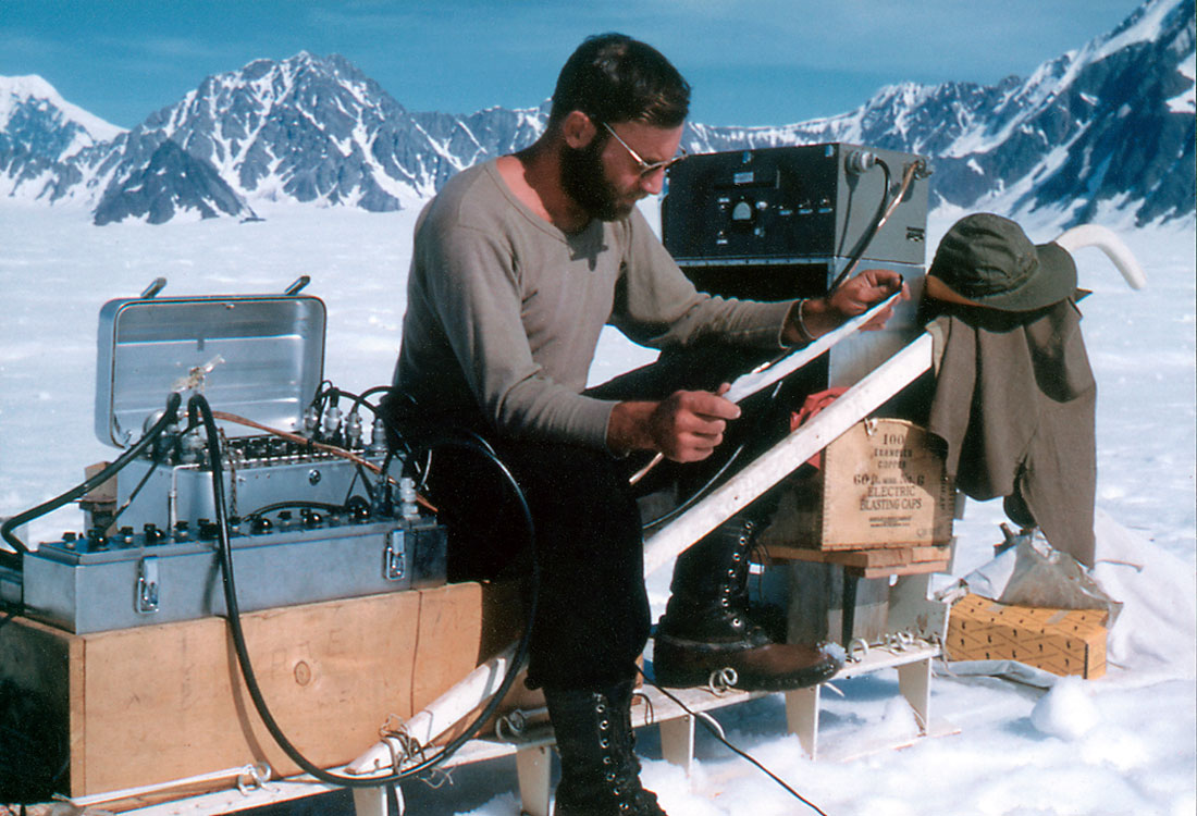
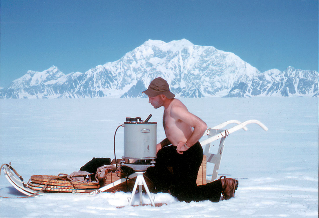
Another unforgettable experience, in the summer of 1949 following Caltech M.Sc. graduate studies was a gravity and seismic survey on the Seward Ice Field in Alaska, west of the Malaspena Glacier and east of the Mount St. Elias Park. Another graduate student, Jack Reece, and myself accompanied Professor Robert Sharp, a widely known glaciologist and educator, We lived in tents on the ice field. This required infrequent moving of the tents due to unequal melting of firn under and surrounding the tents. (Firn is incompletely compacted snow, up to tens of feet thick, overlying ice.) This created a pedestal under the tent with consequential tipping of the tent off the pedestal. Professor Sharp arranged loan of portable seismic recording instruments (Fig. 1) and a gravimeter (Fig. 2) from geophysical companies. Each was mounted on a dog sled. Absent dogs, the sleds were student-powered.
It was necessary to provide a firm base for the gravimeter. For this we used a 2 ft by 2 ft by 4 in. wooden plank on which we mounted the gravimeter for each reading. We discovered that a reading must be made quickly before the plank began to move due to firn melting, making a reading impossible,The large density contrast between ice and bedrock provided gravity profiles giving the bedrock configuration. For the seismic source we used small diameter dynamite cartridges, weighing less than one pound. We melted holes in the firn and ice with electrically heated irons, resembling large soldering irons. The firn melted rapidly. The ice, however, melted at a snails pace. We discovered, fortunately, that the borehole only had to penetrate the ice a few inches for an effective seismic wave from the small dynamite charge . Essentially, detonation in the firn provided no wave. The large contrast in acoustic impedance between ice and bedrock provided distinctive reflections giving good ice depth estimates along profiles. Depths varied up to thousands of feet.
Academia again
Following the Alaskan effort and my marriage in the Fall of 1949, I enrolled in CSM DSc studies. My thesis involved another seismic field survey. Shallow holes were drilled with an air drill into a sandstone outcrop in a Red Rock Park hogback a few miles south of Golden, CO. The source was a small dynamite charge. Detectors were strain gages glued to the sandstone along a line from the borehole. The RECORDER was personally designed specifically for this survey. Recorded signals were compared with signals based on theoretical propagation principles. Professor John Hollister, my thesis advisor, expressed concern for my safety in preparing and detonating dynamite charges alone at a remote location in the Rocky Mountain foothills. His admonition: be very, very careful. I was!
A diversion
At completion of DSc studies in June 1951, I accepted a position with Stanolind Oil and Gas Co. (later named Pan American, then Amoco, and then purchased by British Petroleum and becoming BP-Amoco). Stanolind kindly offered to delay my employment one year to allow me to work as a physicist for the Naval Electronics Laboratory in Point Loma, CA. This provided an excellent opportunity to study and research underwater sound methods for communication and location. The ocean generally has a shallow low-velocity zone in which acoustic signals are effectively propagated long distances (up to thousands of miles). The velocity low is created by the changing characteristics of the water with depth. Propagating acoustic waves are trapped in the low-velocity zone as demonstrated by ray tracing which I used to determine the effects of depth and vertical extent of the low-velocity zone. The Navy sought to use the channel for communication and distress signals from endangered vessels.
Finally, steady employment
Following completion of my year’s tour at the Naval Electronics Laboratory I was assigned to a Stanolind field seismic party operating in the New Mexico portion of the Delaware Basin. It was the only remaining Stanolind owned and operated field party. All others had been replaced by contractor parties Thus started my career in petroleum exploration. Fittingly, I was a field helper for a few months repeating my previous experience on the Atlantic Refining Co. party in Wyoming. Then came assignments to field offices in West and East Texas. Seismic field records were interpreted and maps prepared in the field office. No tape recording and seismic sections from office playback systems in those days, A major event each month was taking the maps, usually accompanied by a geologist, to the Division office in Fort Worth for presentation to management.
Taste of supervision
After a tenure as Party Chief I was assigned to the Tulsa General Office in 1955 and became a technical supervisor, joining two other supervisors, all under the direction of the Chief Geophysicist, Dr, Karl Dyk. My duties involved monitoring seismic field and data interpretation procedures for ongoing surveys in Canada, Alaska, Cuba and Jamaica. These assignments provided broad exposure to a variety of surface features, weather conditions, sedimentary sections, field instruments and vehicles. An interesting aside is an encounter with the Cuban revolution. When seismic operations commenced Battista was in charge of the Cuban government. Subsequently, Castro and his forces invaded Cuba. On one of my visits I was informed that all seismic field parties were assigned Batista soldiers to prevent theft of dynamite by Castro insurgents. I was able to confirm this shortly.
Field operations in Canada and Alaska were unique. Field surveys in northern Alberta, British Columbia, Saskatchewan, and the Northwest Territories generally were confined to winter months when the ground became continuously frozen allowing timber bulldozing for access trails and use of wheeled vehicles. Winter seismic activities were frenetic involving thirty or more seismic field parties. Once from the air we observed parallel bulldozed trails only tens of yards apart. Apparently, one was bulldozed without knowledge that the other existed. Operations after the spring thaw and before the winter freeze required tracked vehicles and travel slowed considerably. Alaskan field operations were in the Bethel Basin of western Alaska and the Copper River Basin of eastern Alaska. A unique condition in the Bethel Basin was the presence of permafrost underlying thick turf which provided insulation keeping the ground continually frozen. Tracked vehicles were required to keep the turf intact and prevent melting. Surveys in the Copper River Basin were confined to roads and operations were normal.
In 1958 the company decided to disburse the technical supervisors. I was assigned to the Canadian Division, headquartered in Calgary and became involved exclusively in this Division’s exploration operations which were in Canada and Alaska. This coincided with the advent of seismic analog field tape recording and centralized tape playback processing which provided record sections, greatly facilitating interpretation and allowing geologists to collaborate in interpretations. This, indeed, was an exciting period and seemed especially so in Canada. It appeared that initial tape field recorders and office processors were sent from the U.S. to Canadian exploration and petroleum companies for trial. This required the development of instrument testing procedures. A technique that proved fruitful was design and preparation of input test tapes containing various test signals for revealing response of the instrument as observed on output records. Activities consisted of visits to field seismic parties and to interpretation offices in Calgary, Edmonton, and Anchorage. Continuous review of technical journals were required to remain abreast of seismic data recording, processing, and interpretation techniques, and effectively collaborate with and advise explorationists.
Introduction to the Gulf Coast
In 1962 I was transferred to our Houston Division Office to become Division Geophysicist for monitoring coastal and marine seismic party field operations and seismic data interpretation. Shortly after my move seismometer spread line length was increased considerably. The purpose was to identify multiple seismic reflections by excessive reflection time moveout and confine interpretation to desirable primary reflections. This technique soon was replaced by multifold subsurface coverage, perhaps one of the most, if not the most, effective seismic field procedure ever devised. Rather than recording a seismometer array (group) only twice, once from a source at each end of the seismometer spread, giving continuous single-fold coverage, each group was recorded several times from source positions at one, two. or more group intervals apart along the seismometer spread, advancing the seismometer spread by the same interval for each recording. In the data processing center, primary reflection normal moveout on each seismometer group signal trace was removed. Also, each trace was corrected for reflection time variations due to near surface variations such as elevation on land and water depth in marine surveys. Corrected traces having common subsurface reflection points then were summed, there by enhancing aligned primary reflections and attenuating nonaligned multiple reflections plus other undesirable events. The effect on primary reflection quality often was startling. Repeating single-fold seismic lines demonstrated that, in many instances, previously mapped subsurfaces were constructed from multiple reflections! Prospective areas were resurveyed using multifold coverage to uncover overlooked petroleum reservoirs. The method was adapted quickly to marine surveys where a detector cable (“streamer cable”) could be towed continuously behind a vessel without stopping for generation of source signals, usually from airguns. This improved operational efficiency immensely, making marine surveys less costly than land surveys.
A short while before transfer from the Houston Office I became involved in contracting the first seismic marine party using digital tape recording. Replacing analog with digital recording increased the dynamic recording range substantially, thus improving signal amplitude accuracy and increasing signal-to-noise ratios. Four partners were required to reduce our cost to our budgeted amount. After considerable solicitation we acquired four. It seemed that overnight we acquired thirteen more partners after word was out that the marine party would be hired. This demonstrated the high latent interest in the effectiveness of digital recording.
Submergence in research
In 1965 I was transferred back to Tulsa to become the Geophysical Research Director at our Tulsa Research Laboratory. Soon after we became involved in the trial of office digital computers for field digital tape processing.. With other companies we contracted a geophysical company (contractor) that had developed this equipment. A principal incentive for such processing was the ability to apply signal deconvolution. This technique, developed by a M.I.T. geophysical group, compressed reflection length by broadening reflection spectra, thereby increasing reflection separation or resolution. Digital processing led to many other effective techniques such as migration of reflections to proximate spatial positions thus improving definition of subsurface structures by untangling reflection overlap. Also this processing provided conversion from reflection time to reflection depth profiles and subsurface structural depth maps. After the development of three-dimensional seismic field surveys, three-dimensional (3D) migration of reflections became possible for the construction of 3D subsurface structures. (Seismic 3D field recording involved recording signals from a swath of seismometer land cables, or marine streamer cables spaced tens of feet apart, thereby enhancing the recording of reflections traveling obliquely to the line of traverse.) These trials led to the installation of processing computers in all Division Offices. Concurrently, several field digital tape recorders were developed by instrument companies and employed by geophysical contractors. Thus. seismic field recording and processing of signal traces soon was entirely by digital methods. Directing research, needless to say. is a challenge. One soon learns that researchists require only broad direction, generally no more than a careful description of the objective. Careful evaluation of a research project is essential to avoid needless and costly termination after disappointing results. Also, the director must be aware of developing and potentially effective seismic, gravity, magnetic, and electromagnetic exploration techniques. The director and his/her staff also must assist in educating explorationists in the effective use of new techniques developed in house or outside by others.
Recruiting duties
An activity not mentioned previously was recruiting geophysicists at universities. For me, this commenced when I became a Technical Supervisor in our Calgary office and continued almost to my retirement from Amoco. Three or four recruiting trips were made yearly. Over the years I recruited in the geoscience departments of nine U.S. and four Canadian universities . This was one of the most enjoyable of activities. Discussing opportunities in exploration geophysics with bright young students and watching those hired become experienced and contributing explorationists was very rewarding.
On to headquarters
In 1968 I was transferred to the Tulsa General Office to become Chief Geophysicist following Dr. Dyk’s retirement. This was a broadening experience in that responsibilities became company-wide. Monitoring of all geophysical exploration and research activities was involved. This required visits to company exploration offices for review of exploration data and objectives. Also required was attendance at industry meetings where technical papers on newly developed or presently developing geophysical exploration instruments and methods were presented. Personnel management also was involved. Advice on the training, promotion, and transfer of geophysicists was required, Attendance at routine General Office management meetings in Division offices for review of exploration results also was required. Upon invitation, I also visited data interpretation offices and reviewed geophysical exploration activities in England, Norway, and The Netherlands.
Research revisited
In 1971 I was reassigned to the Tulsa Research Laboratory again as Director of Geophysical Research. Innovations in seismic digital data recording and processing were in ascendancy. One method for preserving relative reflection amplitudes (so called “true amplitudes”) after reflection normal moveout removal resulted in a startling discovery. Under unique circumstances hydrocarbon reservoirs are revealed by anomalously high reflection amplitudes, called the “bright spot”. Generally, this is restricted to highly porous sands for which the contained fluid has appreciable effect on reservoir seismic velocity. A slight amount of gas (say, less than 5% of the total fluid volume) reduces the sand reservoir seismic velocity and appreciably increases the reflectivity of, say, a shale-sand reservoir interface, increasing the amplitude of the reflection from this interface, Unfortunately, additional gas does not further increase reflection amplitude and gas volume is not related significantly to reflection amplitude variation. An untold number of wells were drilled on the basis of bright spots, only to find that the gas quantity was insufficient for commercial production. Oil has much less effect on reflection amplitude.
Final position
In 1976 I became a Research Consultant and commenced a most rewarding and exciting period in my career. In 1977 I was “elected” Editor of the SEG journal Geophysics. There is only one candidate for this position, selected by The SEG Nomination Committee. The editor serves for two years and is responsible for review and acceptance of technical papers submitted by SEG members and, occasionally, others. To assist in the review he is assigned volunteer Associate Editors. The Editor returns the author’s paper with modifications recommended by an Associate Editor who is familiar with the discipline(s) involved in the paper. If appropriate the Editor also makes recommendations.. At times I became a referee when there were differences of opinion between the author(s) and Associate Editor. Review of the papers is a very broadening experience. The editor is exposed to many disciplines for which he has little or no experience and must rely on Associate Editors who are experts in these disciplines.
My editorship coincided with the the 50th anniversary of the SEG (1930-80). In commemoration of this anniversary the 1978-79 SEG Executive Committee authorized preparation and publication of a brief history accompanied by histories of geophysical methods. For the latter we solicited preparation of descriptions from experts in the methods. These were (1) seismic, (2) gravity, (3) magnetic, (4) electrical, electromagnetic, and magnetotelluric, (5) well logging, (6) remote sensing, and (7) radioactivity.
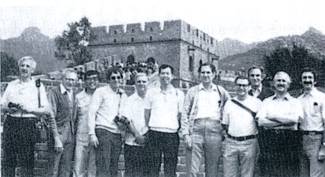
Another memorable event was a visit to the Peoples Republic of China (PRC) with ten other SEG members (Fig. 3), Sept. 5-27, 1977. In exchange, an equal number of PRC geophysicists visited the U.S., Oct. 26-Nov. 16, 1978. Purpose was to tour and present technical papers at geophysical research facilities, geophysical instrument factories, university geoscience departments, and petroleum company offices. A total of eight presentations were made. PRC geophysicists reciprocated by also presenting technical papers.. A field seismic party was visited. Our visit was shortly after President Nixon’s PRC visit and the Chinese were not accustomed to foreign visitors. Almost at all locations we were followed by curious natives, some of which were anxious to practice speaking English learned in classrooms. The dress at that time was almost entirely Mao-style for both men and women.
In 1980, with the company’s permission, I accepted a part-time teaching position as a visiting professor in the University of Okahoma School of Geology and Geophysics. The procedure was to drive to Norman, OK on Friday afternoon for a Saturday morning class on seismic exploration. This I did until my retirement from the company in l983. Shortly before and following retirement I taught a one-week course on seismic exploration for Oil and Gas Consultants, Inc. This was a global experience with sessions in the U. S., Canada, England, India, Australia, Indonesia, and Venezuela.
Post-Amoco retirement
Following retirement from Amoco, I accepted a visiting professor position in the Geophysics Department at Baylor University in Waco, TX. Involved was a weekly session on the stratigraphic analysis of seismic data. The procedure was to fly to Waco the afternoon before the lecture. This was an extremely rewarding experience with bright, dedicated students anxious to learn about seismic exploration. An example of the rapidity of advances in technology was the experience of a geology student. After completion of a course in stratigraphic analysis of seismic data she became a summer intern with a major oil company. Returning to Baylor in the Fall she exclaimed that she knew more than her supervisor!
In the summer of 1987 I received a seven-week assignment and, again in 1990 a four-week assignment by the United Nations to the Beijing Computer Center. The first assignment involved lectures on seismic exploration principles, data processing , and interpretation. These were followed by reviews of papers on recent significant developments in geophysical exploration. Also involved were consultations on current seismic surveys in various prospective areas in China. The second assignment involved, principally, the stratigraphic analysis of seismic data. A series of lectures on principles, demonstrated by published exemplary seismic sections from sedimentary basins, were interspersed with stratigraphic analyses of seismic sections from active exploration areas in China. An interesting aside was an encounter with the 1989 student riots in Beijing’s Ten An Men Square. The second United Nation assignment originally was scheduled for the summer of 1989. The day before my scheduled departure these riots commenced. The assignment was quickly rescheduled for the following year.
I finally ceased my teaching activities in 1991 and became fully retired , except for membership on SEG committees and participation in other SEG activities.
Final thoughts
For those interested in physics and earth sciences I must unequivocally recommend exploration geophysics. For me it has been an invigorating, challenging, and fulfilling career. Uncovering features, such as subsurface structures containing mineral deposits or petroleum reservoirs, buried artifacts, salt structures, mined tunnels, etc. is exhilarating. All is accomplished by measurements of natural earth fields (magnetic, gravity, radioactivity) and/or probing the earth by artificial fields (seismic waves, induced electromagnetic fields, electrical currents) Added to this is the continual improvement and sophistication of data processing techniques and exploration instruments.
For those exploration geophysicists who become involved in surveys outside their native country, there is the opportunity to observe foreign cultures, visit historical sites, and establish lasting friendships with native citizens and professionals.
Finally and most importantly, I must acknowledge the constant support of Shirley, my wife for fifty-six years. After each of our many moves she made a home and managed to raise a family, giving each member sound guidance.


Join the Conversation
Interested in starting, or contributing to a conversation about an article or issue of the RECORDER? Join our CSEG LinkedIn Group.
Share This Article