Quaternary geology is fascinating, especially the late Pleistocene and into the Holocene (11,700 years ago to present) because it’s so recent, dynamic and all around us. In my article on the Spokane Flood (Kuhn, 2008), I alluded to the possibility that maybe, just maybe, humans had witnessed this catastrophic event. Here I will cover a similar series of geological events related to glaciers and water that most definitely were witnessed by humans. The period covered here is between 14,800 and 9,500 years ago, the area the Great Lakes region.
Introduction
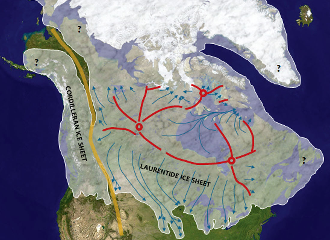
Over the last 1.5 million years there have been many glacial periods that have shaped the Canadian Shield, but not much is known about the topography of the Great Lakes region before 100,00 years ago. It is only since then that the Great Lakes in their current form were created. The Laurentide ice sheet (Fig. 1) covered most of Canada starting about 95,000 years ago, pulsed in and out in several episodes, and began its final retreat around 14,800 years ago. With each pulse forward the various glacial lobes carved out deeper and deeper depressions that eventually became the Great Lakes basins as we know them today.
As a quick Western aside, Figure 1 also shows the Cordilleran ice lobes that played a key role in the formation of glacial Lake Missoula and the Spokane flood (Kuhn, 2008), and also illustrates how the Laurentide ice sheet butted up against the northern slopes of the Cypress Hills. Exciting and dynamic glacial forces were at play all over Canada. Massive lobes of ice moved outwards (blue arrows) from domes (red circles) and divides (red lines) deep inside the continent. The Rocky Mountains (orange line) created a barrier between the huge Laurentide ice sheet that covered most of the Canadian Shield and more, and the not insignificant Cordilleran ice sheet to the west.
But back in central Canada… during every retreat of the Laurentide ice sheet, meltwaters created proglacial lakes, water trapped between the ice sheet and terminal moraines. These lakes grew and evolved, finding outlets to the sea. Their descendants are still with us – the Great Lakes, Lake Winnipeg, etc. – but these paleo-lakes expanded and contracted over time due to a few factors. The lakes’ ability to drain was determined by the available outlets. At times some outlets were blocked by the retreating ice and so water flowed through outlets in the south. For example water that would now flow out through the St. Lawrence at many times flowed south through an outlet near Chicago, and through the Illinois River into the Mississippi.
Outlets were also affected by glacial rebound – as the ice sheet retreated to the north, land to the south lifted and outlets were stranded, forcing water to find ways out through alternate routes in the north that were now relatively lower. This switching of outlets meant the levels and areal extents of lakes could change dramatically and quickly. Geologists have put together a detailed description of these changes in the Great Lakes region. Some of the key pieces of information include terminal moraines (which indicate the limit of a glacial lobe’s extent), paleo-shoreline terraces, paleobotany, shoreline remains of human settlement, and remains of flooded forests found at the bottom of the current Great Lakes.
Graphical Time Line
The series of maps in Figure 2 shows the evolution of the Great Lakes region, along with accompanying notes. For the underlying map of the Great Lakes I used the “Great-Lakes” image by Phizzy found on Wikipedia and licensed under CC BY-SA 3.0 via Commons (Phizzy, 2008), and for the inferred glacial coverage I mainly used course notes from Michigan State University (Schaetzl, 2015) and a US Geological Survey report (Larsen, 1987).
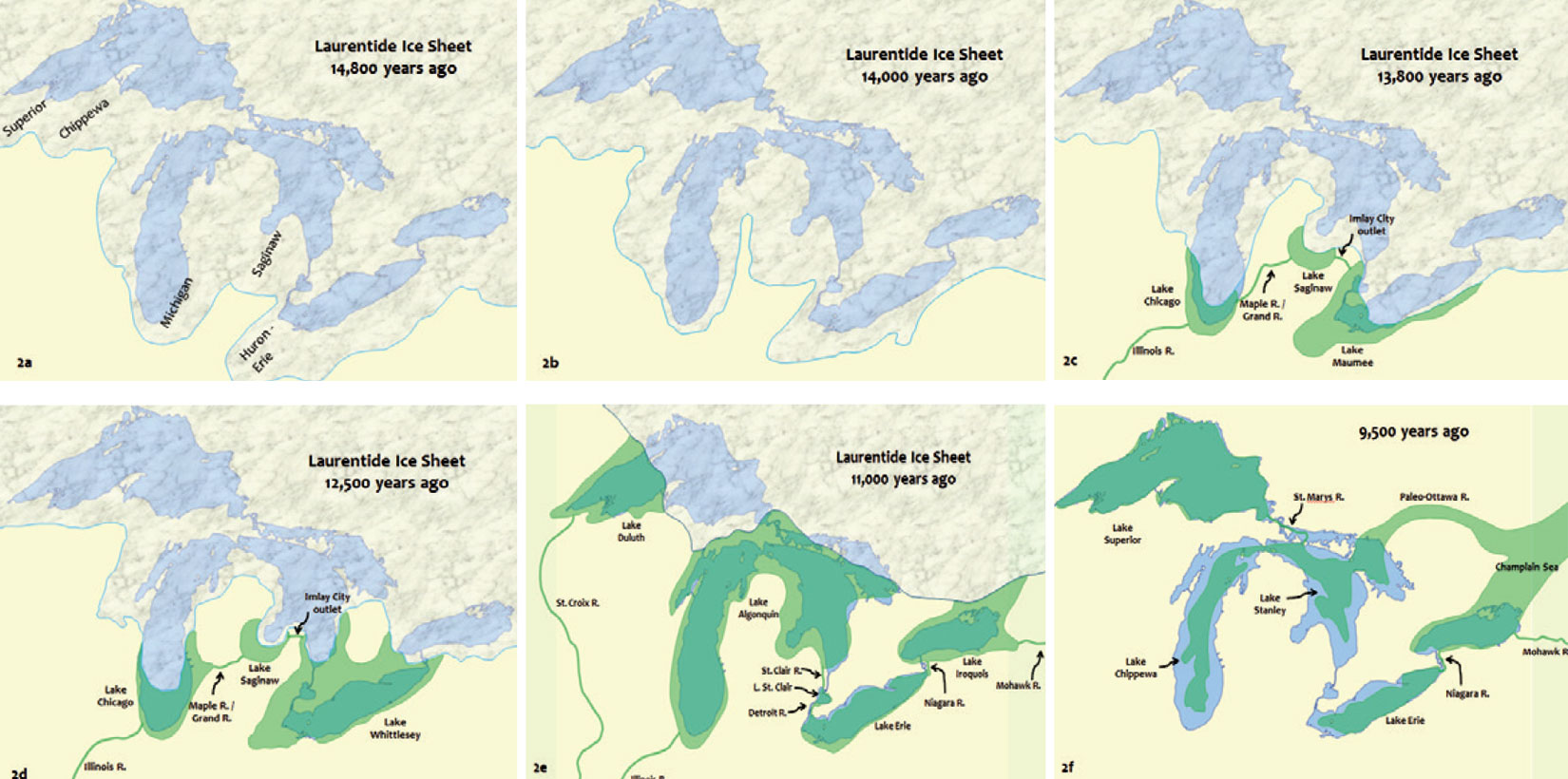
Figure 2a shows the Great Lakes region 14,800 years, when the Laurentide ice sheet was just starting its final retreat. The entire region is under ice, and the six main lobes are discernible, as indicated. All water shed by the ice sheet flows south to the Gulf of Mexico. Just 800 years later, the ice lobes have retreated, most noticeably into upstate Michigan and New York, leaving behind terminal moraines to the south (Fig. 2b).
In only ~200 years the depressions between the retreating lobes of ice and the terminal moraines have filled with meltwaters, creating the first three proglacial lakes – Maumee, Chicago, and Saginaw – and these drain south through the Illinois River into the Mississippi (Fig. 2c). Remains of the two little connecting rivers can be seen today, especially a deep channel just east of Imlay, Michigan. By 12,500 years ago (Fig. 2d) the Erie Basin has filled up to form a huge paleo-lake known as Lake Whittlesey, and it still drains west through Lakes Saginaw and Chicago, then south.
By 11,000 years ago (Fig. 2e) all of the Great Lakes are uncovered except the eastern half of Superior. Glacial Lake Duluth fills the exposed west, and drains into the Mississippi via the St. Croix River. Where Lakes Michigan and Huron are today is a massive single Lake Algonquin. Around this time glacial rebound in the south raises and strands the outlet near Chicago, shifting the water outflow to a Port Huron (Sarnia) outlet. From here it flows south as it does today, but through a St. Clair-Detroit River with a slightly different channel, into Lake Erie, and then over ancestral Niagara Falls into glacial Lake Iroquois. The Falls are much further north than they are today, as 10,000+ years of erosion is still to come. The future St. Lawrence graben outlet is still blocked by ice, so water flows to the Atlantic through the Rome outlet and the Mohawk and Hudson Rivers.
By 9,500 years ago (Fig. 2f) the Laurentide ice sheet has fully retreated. Glacial rebound takes time (it’s still happening today), so elevations are very low, especially in the northeast where an outlet near North Bay has opened up via Lake Nipissing and the Mattawa River, allowing Lake Superior, glacial Lake Chippewa (Michigan) and glacial Lake Stanley (Huron) to drain out through the Ottawa River to the Champlain Sea, which is a huge Atlantic Ocean estuary. The penetration of the Champlain Sea up the Ottawa Valley and into the former Lake Iroquois would have varied depending on sea level fluctuations. Over the next few centuries the northern outlet closes, which reestablishes the Port Huron outlet, and the Great Lakes basins refill, forming more or less their current shapes, subject to fluctuations.
Human Experience
Space does not allow me to delve as deeply into the human side of this story as I wished. However, I have included two more figures (a picture is worth a 1,000 words!) and some relevant references. Figure 3 shows the inferred Lake Algonquin shoreline about 11,000 years ago, in the Muskoka region north of Toronto. The little yellow crosses indicate human sites – remains tend to be preserved better in the earth of farmers’ fields on the southern edge of the Shield, rather than the bare rock further north.
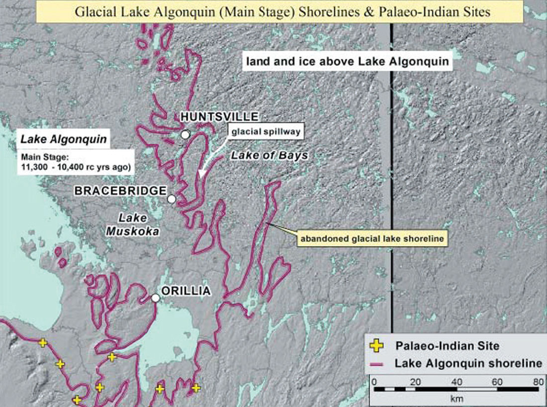
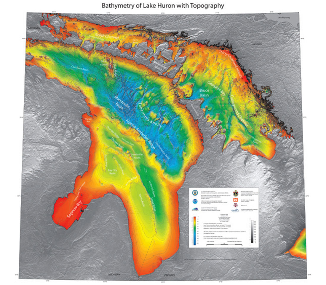
Figure 4 shows the bathymetry of Lake Huron; yellow indicates current water depths of 40m to 60m. During the Lake Stanley period (11,500 to 7,000 years ago) water levels were up to 100m lower than today, thus there was a land bridge across the Alpena-Amberley Ridge (Alpena and Amberley being the Michigan and Ontario towns closest to either end. Note that Google Earth now shows Great Lakes bathymetry.) This land bridge was rapidly flooded about 8,000 years ago. Underwater archaeology has discovered clear evidence of humans, including rock caribou hunting drives similar to those found at Head-Smashed-In-Buffalo- Jump, and numerous other sites around the world (O’Shea, Lemke, Sonnenburg, Reynolds, & Abbott, 2014). Carbon dating yields ages of about 9,000 years ago, for example 9,020 from charcoal found in a ring of stones suggestive of a camp fire. I picked these two figures because in that 2,000 year interval, the humans in the Great Lakes region went from living on the shores of Lake Algonquin (Fig. 2e), almost twice the size of modern day Lake Superior (the world’s largest lake), to a region with much smaller, skinnier lakes (Fig. 2f); the former shorelines they once inhabited moved up to 100 km further west, only to be re-flooded again around 8,000 years ago. Imagine the dramatic changes these people must have lived through, and their experiences, and myths and legends created to explain those changes. If only these and other cultures had developed ways to record their history as more recent cultures have… the stories of their worlds have been lost to time, and can only be clumsily inferred and imagined from the geological clues left behind.


Share This Column