GIS technology, especially Google Maps and Google Earth, has given anyone the ability to view even the remotest parts of the globe. When my grandparents were young, in the late 1800’s, there were huge areas of the Earth that were simply blank spaces on western maps. The source of the Nile was “discovered” in 1858 by John Hanning Speke, Roald Amundsen’s team were the first to reach the South Pole in 1911, and so on, but these were just obvious targets of expeditions, while vast tracts of wilderness went unexplored. I actually get irritated / amused by the western world’s use of the terms explore and discover, because almost every region on Earth that was supposedly explored and discovered by Europeans was already inhabited by humans. But anyway, now without leaving my desk I can zoom in on anywhere – in a couple of generations the Earth has gone from a place of many mysteries, to one that is easily viewed from the comfort of our desks.
It’s become a hobby of mine that, upon reading of a place or geographical feature, I immediately look at it on Google Earth, and I’m sure many CSEG readers do just the same. I check out historical references, locations in the news, and sometimes I just zoom in on places because they’re interesting in some way. But what really gets me excited is when I can spot archaeological features. I think this started when my friend John Behr told me about a pre-European culture in Bolivia with an economy built around extensive fish dykes, weirs and dams. We were able to discern their faint remnants on Google, and then there was no looking back – whenever I read of an archaeological discovery, I try to view it on Google Earth. This hobby I stumbled on to is in fact a method used extensively by archaeologists, ever since humans were able to get a bird’s eye view of the landscape. In this article I will share some favourite “discoveries” of mine, along with a quick look at the use of aerial imaging by professionals engaged in true archaeology. Note that I’ve included lats and longs in the figure captions – readers can enter these coordinates in Google Maps to see for themselves.
I had hoped to involve CSEG member Paul Bauman in the writing of this article, as he has become well known in archaeological circles for his use of high resolution aerial photography from kite-mounted cameras, but he’s extremely busy right now. He called me from Lake Turkana, not far from where Speke discovered the source of the Nile with the help of hundreds of local porters. Paul actually authored an article in the RECORDER that features aerial photography, which is worth checking out (Bauman, Goren, Freund, & Reeder, 2005). Chatting with Paul, he said, “By the way, technically, yes, kite photography is obsolete. However, because of Transport Canada rules and simply logistical reasons, it can be more practical to quickly yank out a kite and camera stuffed in a backpack than to file flight plans months ahead of time.”
Baures Fish Weirs
For many decades people have been aware of large scale South American earthworks, but they didn’t attract much interest in archaeological circles, probably because the focus of classical archaeology tended to be on sites with palaces and temples, containing bones and valuable artefacts. But lockstep with history, which has evolved from a discipline focused on battles and other momentous ruling class events to one studying all facets of a culture including the lives of ordinary people (referred to as social history), archaeology now looks at the broader remains of past cultures.
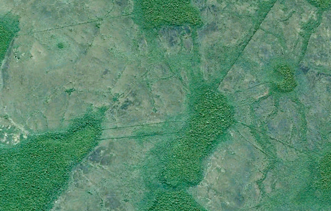
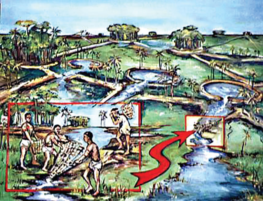
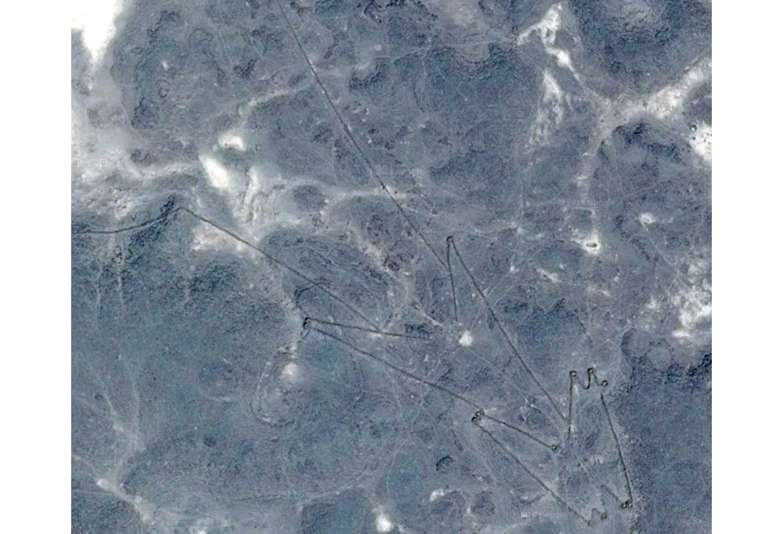
One area that has recently drawn attention is in NE Bolivia, in the vicinity of Baures. Here as I mentioned earlier, clearly visible from the air, one can see the remains of an ancient water management system, over a large area, at least 550 km2. Figure 1 shows the key components, and Figure 2 shows an artist’s depiction of what the domesticated landscape might have looked like. The straight lines are raised earth dykes, which contained seasonal flood waters, and acted as roads connecting villages and provided access to sluice gates and other operational features. The large “islands” connected by the dykes would have been where villages were located, as well as farming plots for some types of crops. The smaller circular treed areas contained within the dykes are the remains of deeper fish ponds which would have held live fish well into the dry season. There are numerous articles on this culture, and the technologies their economy was built around, but the key point to make here is that these earthwork features are visible with Google Earth and Google Maps, and aerial archaeology played a large role in their discovery and subsequent analysis.
Erbil Plain Waterworks
Erbil has been in the news lately for all the wrong reasons, but human conflicts are old news for this region, which is home to some of the earliest known sites of human settlement. Who knows how many times the Erbil Plain has been witness to petty human wars over territory, resources and ideology? There are layers upon layers of archaeological remains at sites that have been continuously occupied since humans first transitioned from being nomads to settled farmers. Farming in this region involves irrigation, and so canals, both above ground and underground, figure prominently. A technology employed since medieval times, probably longer, is a type of underground canal called qanat (Wikimedia Foundation, Inc., 2014). These tunnels were (and still are in some parts of western China, where they are called karez) dug by hand, bringing precious water from highlands down to farms in the drier plains. Vertical shafts every 25 m or so were used to bring the excavated rock and soil to the surface in a way that minimizes evaporation.
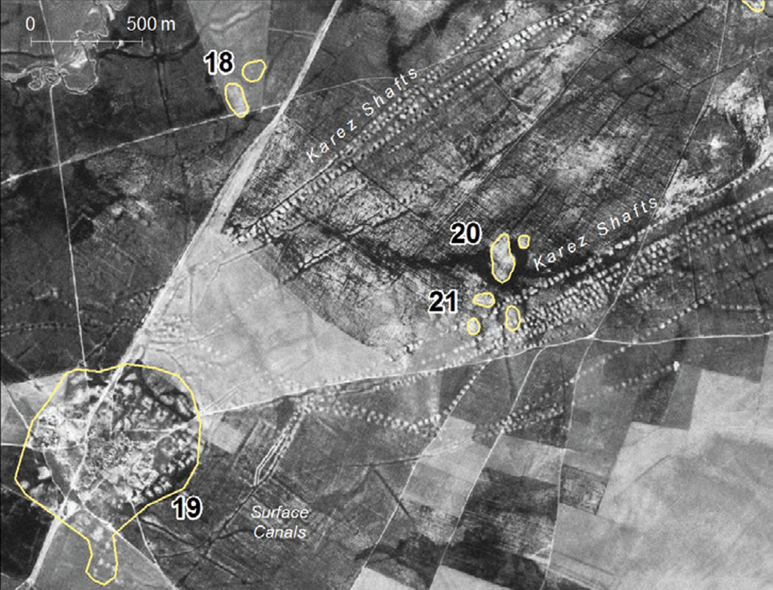
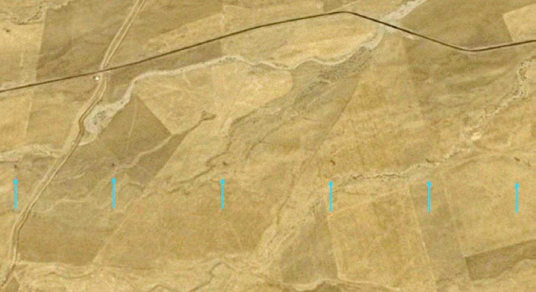
I recently came across a very interesting paper entitled Ancient Cities and Landscapes in the Kurdistan Region of Iraq: The Erbil Plain Archaeological Survey 2012 Season (Ur, De Jong, Giraud, Osborne, and MacGinnis, 2013). What caught my eye was that the study used old CORONA satellite images to identify sites of interest. Apparently a large number of images captured by US spy satellites became declassified in 1995, and archaeologists have been using these extensively. These images from the 1960’s and 1970’s show features that are now obscured by urbanization, but in many cases the archaeology is still there under the surface (Fig. 3). Erbil itself was a town of about half a square kilometer in the 1940’s, but now covers an area of perhaps 200 km2. Many of the images clearly show evidence of the qanat shafts down to the tunnels, seen as lines of dark circles. I’ve scoured the Erbil plain with Google Earth, and the qanat are very hard to find now, but I have found a few traces (Fig. 4).
Kites and Keyholes
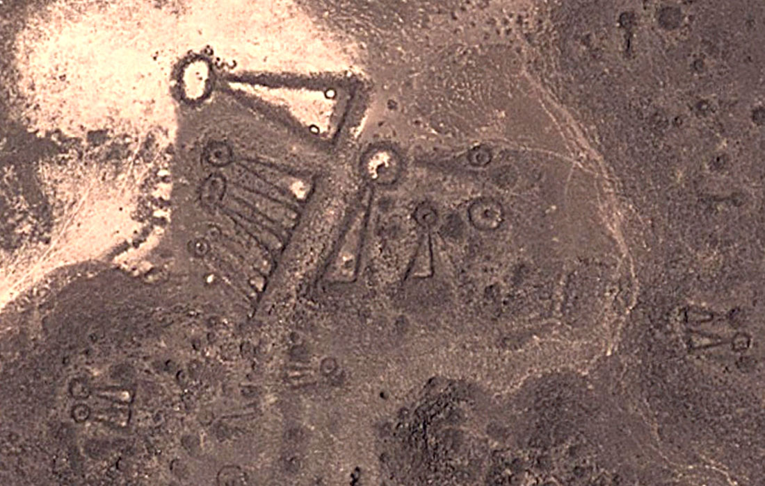
Saudi Arabia is rich in archaeology, and many features are clearly visible with Google, because of aridification – regions where early humans lived used to be more fertile, but are now uninhabited desert, with nothing to obscure ancient structures. In Harrat Khaybar, a vast region of surface volcanics and shifting sands north of Medina, there are hundreds, maybe thousands of ancient stone hunting blinds. They have a very characteristic shape that resulted in WWII RAF pilots calling them kites, and the name has stuck. They essentially acted as funnels, into which hunters would drive migratory animals in a fashion very similar to that employed at Head-Smashed-In-Buffalo-Jump. However, instead of a cliff at the end of the funnel, there would be a sort of corral, with conveniently placed blinds from which hidden hunters could shoot arrows and throw spears. These structures have been roughly dated to around 5,000 BC, and corresponding rock art suggests that the climate was much wetter back then, and the region abundant in game animals, such as onager, various gazelles, and oryx. When I first read about these kites I just typed in ‘Harrat Khaybar’ as the search term and immediately zeroed in on several of them, they are that obvious (Fig. 5).
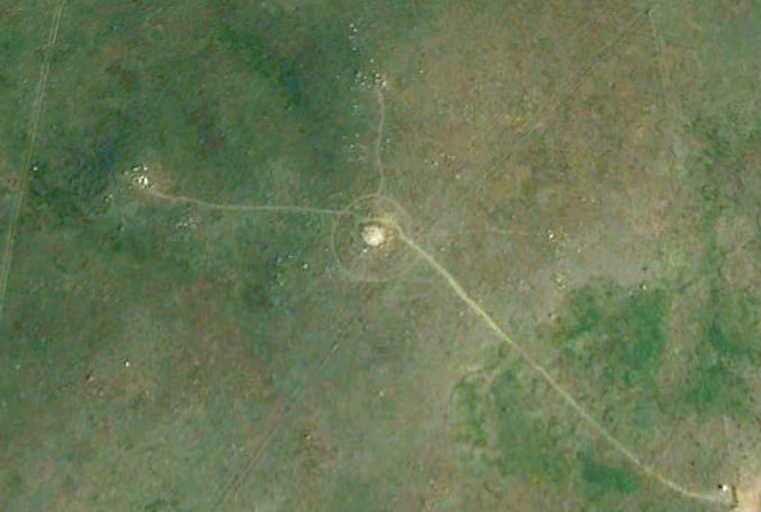
Speaking of Head-Smashed-In-Buffalo-Jump, there are many interesting features to be seen on the high ground west of the site, but I’m not sure what I’m looking at, or what I should be looking for. But one fun feature to look for all across the North American plains is the Medicine Wheel. They’d be almost impossible to randomly find, but a quick Google search on “medicine wheel locations” will get you rough locations. Figure 6 shows a Google Earth image of a medicine wheel east of Milo, Alberta.
Also in Harrat Khaybar are found various types of burial structures, but the ones I find most interesting are known as keyholes or pendants – Figure 7 shows some typical examples. Archaeologists believe that people were buried in the centres of the circular areas. I’ve wondered whether there is some symbolic significance in the similarity between the kites and the albeit smaller keyholes. Perhaps these people relied on the game they killed, and so the place where the killing was done held some religious importance, such that when members of the community died, they were buried in miniature replicas of the kites. A reverence for animals killed is a common theme among early humans, for example as expressed in European cave paintings.
Professional Archaeology
Archaeologists have actually employed various aerial view methods for hundreds of years. I bet it started with climbing trees and hills to get a bird’s eye view, but as technology became available it was used – hot air balloons, cameras on kites, airplanes, satellites, and of course now, drones. The advantages are obvious. On the ground it is difficult to get the big picture, and many features are simply not discernible up close. From the air, subtle features form recognizable patterns, and the broader context of a site can be inferred.
The effects of humans can be remarkably long lasting. For example, any depressions created by humans – such as ditches, collapsed tunnels or tombs – will collect more water, and so over time the vegetation changes. In the case of the qanat mentioned above, the excavated soil tends to be more clayey and thus lighter, and so from the air the vertical excavation shafts can appear as dark circles with light rings around them. Ancient building materials may break down over time, but the resulting soil has a different chemical composition than that around it, meaning the faint outlines of walls can be seen from the air. Very subtle differences in the topography can be discerned from the air due to shadow effects, and the use of LiDar and multispectral data has added new dimensions and helped uncover features previously invisible to the human eye, due to vegetation cover or other factors.
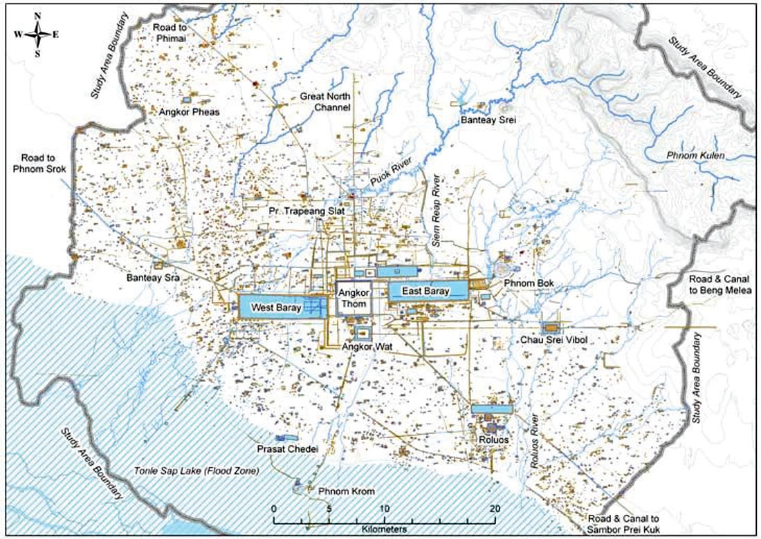
A tragic example of the visible manifestation of human activity is described in a paper on the excavation of a Nazi death camp, in which Bauman’s aerial photographs (Fig. 8) were used to help identify mass graves by differences in the colour of the foliage and other vegetation (Gilead, Haimi, & Mazurek, 2010). I’ll finish off with a quick mention of Angkor Wat. It is an example of an enormous temple complex that has been studied / plundered for centuries, but it is only now through the use of aerial imaging and other technologies like GPR that archaeologists are grasping the scope of the large urban complex that surrounded the better known temple structures. Invisible from the ground, old buildings, walls, canals and all sorts of features have been revealed by aerial imaging, and this has resulted in an increasingly better understanding of the site, as shown in the Figure 9 map.


Share This Column