Think of the world’s great civilizations – the Egyptians, the Romans, the Chinese, the Greeks... how about the Polynesians? Not at the top of most people’s list, yet the Polynesians (I use the term in a general sense to encompass the Polynesians, Melanesians, Micronesians and all the other categories given to the peoples of the Pacific Basin), beginning in approximately 3,000 BC, were able to populate one third of the earth’s surface. They were masters of their domain, surely at least the equals of the other great civilizations of history. In order to survive and thrive they had to navigate enormous distances over open water, with essentially Stone Age technology.
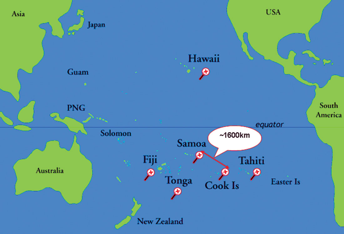
The distances they routinely travelled make the great voyages of the western world many centuries later seem puny in comparison. Imagine setting off from Samoa to the Cook Islands, a mere 1600 km (Figure 1), in a sailed outrigger canoe with just your family and a bit of food - no problem for the ancient Polynesians. How did they do it? The secret lies in their navigational techniques, which are very interesting from a scientific point of view. Undoubtedly many of these techniques have been lost over time, but luckily a few enthusiastic and persistent people made efforts to document them before the slide of the Pacific cultures into the modern world and all its conveniences, by interviewing knowledgeable elders and undertaking voyages on traditional vessels with them.
Much of the material here comes from what is considered the classic work on this topic, We, the Navigators: The Ancient Art of Landfinding in the Pacific, written by David Lewis. This column will focus strictly on the science of traditional Polynesian navigational techniques, but interested readers can use this excellent book as a starting point for further forays into other fascinating aspects of Polynesian culture, such as differences from island group to island group, reasons for regular inter-island travel, religious practices, types of water craft used, etc.
Polynesian navigational techniques and knowledge were typically closely held by a small elite group of men in each island group (the term secret society has been used to describe this), and were handed down in apprentice-type systems over many years. Note that navigation seems to have been an exclusively male role, though I’m sure there were exceptions. The challenge, time required, and difficulty of becoming a master traditional navigator has been compared with getting a doctorate in our culture. The full variety of methods learned can be conveniently divided into three main categories:
- Setting and maintaining a course
- Orientation / dead reckoning
- Finding landfall
Setting and maintaining a course
The Polynesians employed a number of techniques to set and maintain their course. They had to navigate during day and night, during clear and cloudy conditions, during wind and calm. This meant that they couldn’t rely on just one method. There are four categories defined by the physical phenomena they relied, each containing many specific skills and variations: the stars, the Sun, swells, and the wind.
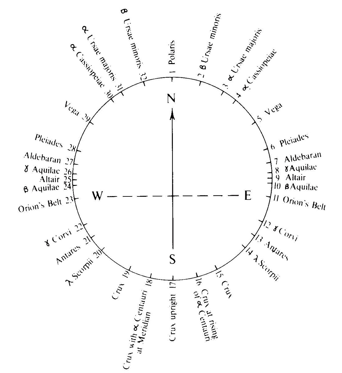
The stars. For night travel the preferred way to set and maintain a course was by using the stars. The Polynesians employed what is known as a sidereal compass. It isn’t a piece of equipment like our compass, rather it is a mental compass that combines a memorized knowledge of where key stars rise and set, and which islands and waypoints are associated with these near-horizon star azimuths. Regardless of season, each star rises and sets at the same latitude on the horizon. In other words these points are fixed. The further a given star’s latitude varies from the latitude of the boat using it as a guide, the less use it will be higher in the sky, as its ascending arc in the night sky will slant obliquely away from the craft.
If you were in charge of navigating from Samoa to the Cook Islands, you would have learned a map of star points to guide you, a succession of star points that you would set course by. Lewis describes a voyage of about 100km from the Reef Islands to Taumako, with a local navigator named Tevake. He first aimed for Betelgeuse as it rose for about 2 hours, then a point midway between Castor & Pollux and Procyon for about an hour, then a third star known locally as the Crab until midnight, and so on. Typically a maximum of ten star points would be used in one night. Figure 2 shows a sidereal compass from the Carolinian Islands.
The Sun. Navigating by the Sun during the day is inherently less accurate than night time travel with the sidereal compass. This is because on any given day the Sun provides only four fixed points – east and west bearings at sunrise and sunfall respectively, and north and south at high noon. Furthermore, one has to factor in the seasonal variations as well, for example sunrise and sunfall determine true east and west only at the equinoxes. So navigating by the Sun involves a lot of interpolation, between sunrise and noon, noon and sunfall, and day to day seasonal corrections. Of course this would have become second nature to skilled navigators, but nevertheless this method is inherently somewhat vague and necessitates additional techniques to complement it.
Swells. These are described as large wave systems or groups that have travelled great distances and are generated by strong and persistent winds such as trade winds, as opposed to variable local winds. This means that they reliably occur year after year, coming at the same time every season, from the same direction. Swells tend to be distinguished by their consistency and lower frequency, whereas local waves that could be misinterpreted tend to vary in amplitude and have higher frequency characteristics such as breaking crests. Swells vary greatly from island group to island group, and season to season, so to be of any use the navigator must memorise the swell systems in his realm of interest. In other words, if a Samoan navigator was dropped down into the Solomons, without local knowledge the swells would be useless to him.
On the return voyage to the Reef Islands, Tevake showed Lewis how he used the three main swell systems present in that region. For over 8 hours the Sun was obscured and they passed through several storm systems. Tevake stood on the prow of the ship with a banana leaf umbrella over his head and “read” the three swells coming from different directions, indicating course by hand to the man on the tiller in the rear. On this occasion the “Long Swell” from the SE was dominant but Tevake didn’t use it, the “NW Swell” was imperceptible and Tevake didn’t use it either, and instead he focused on keeping the ENE “Sea Swell” at a particular angle astern, judging it by the pitch and heave of the boat, ignoring the effects of local squalls and waves. They covered approximately 80km and were perfectly on course when they sighted land.
There are many stories and legends of expert navigators able to detect and steer by swell patterns. The most outlandish and certainly most entertaining aspect of this is the assertion that many of these navigators would sit or lie in a way that their testicles were in contact with the boat, allowing them to better detect the subtle swell-induced motions.
Wind. Although in many parts of the Pacific there are dominant wind directions, and in fact there is evidence that many islands used “wind compasses”, the variable nature of wind makes it a tricky and unreliable guide. However, since the Polynesians relied on wind to power their crafts, they were intimately aware of its constantly changing direction and continually factored in its angle relative to their other navigation guides – stars, swells and Sun. Various methods were employed to detect shifts in wind direction, such as pennants. It’s safe to say that wind direction was used as the primary directional guide only as a last resort, and more typically would be used to stay more or less on course until one of the other, more reliable methods became available again.
Orientation / dead reckoning
As anybody who has spent some time on a boat in open water knows, it’s one thing to choose a course, but an entirely different matter to be able to maintain that course when any number of effects is pushing you off your ideal course – primarily current set and wind-drift, and the more extreme variety of wind-drift known as gale-drift. On top of that the navigator must continually estimate the boat’s speed and the true distance covered. Taking into account all these factors, determining current position and choosing the direction to take from moment to moment is termed dead reckoning.
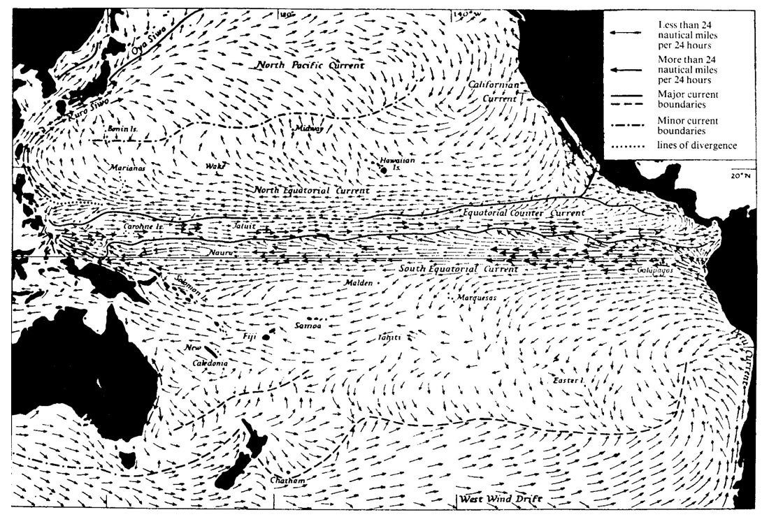
Current set. If you choose a bearing to travel to reach your destination, say true north, and stick to your course, then in the absence of any winds or currents you should reach your goal. Imagine however that there is a strong current from east to west unbeknownst to you. Instead of reaching your destination you will pass by it well to the west. To correct for current set the Polynesians basically needed to master an encyclopedic knowledge of the currents in their realm. These currents of course vary from season to season in strength and direction, and are affected by the topography of the ocean floor. All of this needed to be learned and then appropriate corrections applied as the boat moved through the water. Figure 3 shows dominant Pacific currents in our (northern) summer. The longer the arrow, the more variable the current. Take this and then imagine the myriads of subtle local variations – all required learning for the master navigator! One interesting aspect of current-induced errors is that the longer a voyage was, the more likely the random errors would cancel out. This meant that if a navigator left his zone of expert knowledge, if he had an idea of the dominant currents, he could assume that his lack of local knowledge would likely cancel out as the errors would be random.
Wind-drift. Unless the boat is travelling perfectly downwind, it will not go directly in the direction it is being steered. This can simply be thought of in terms of vectors. If the boat is heading directly north and the wind is from the northwest, then the direction the boat actually travels is a few degrees east of north; the boat experiences a wind vector component in line with its desired direction, and a vector component at 90º to it. The path travelled is represented by the sum of the two vectors. (In more detail the force generated at the sail comes from a Bernoulli effect of the wind travelling faster over the outside of the sail than the inside, so the vector directions are not totally obvious.) The angle between direction steered and direction made good is termed leeway.
To identify and compensate for wind-drift the navigator needed to draw on considerable knowledge and experience. First of all he would need to be familiar with the reaction of his specific vessel to wind – the primary factors being hull shape (i.e. resistance to displacement), wind direction, boat speed, and nature of the waves. With this information in his head, he would most often look astern and judge leeway by the angle between the boat’s wake and direction travelled. By all accounts this skill relied heavily on an intuition built on many years’ of experience.
Gale-drift. Occasionally these traditional seafarers would experience gales, storms of a size and fury that rendered their traditional techniques useless for a period of hours or days. In these cases they would typically lower their sails and masts, and in extreme cases even swamp their boats on purpose (being made of wood, reeds etc. they floated) in order to ride out the waves better. They would then ride out the storm and all the while try to keep track of where they were being blown relative to where they came from. This would involve all the methods already mentioned. When the storm abated they would head back home or try to get back on their original course if it still made sense. Probably some of the more remote island groups were discovered as a result of gale-drift, although far less than the early European explorers condescendingly estimated.
To a person unfamiliar with storms and traditional Pacific navigation it would seem that a gale-drift situation would be a worst case scenario. In fact many storms have a circular nature (cyclones) and Pacific islanders often assume that when a storm is over that unless they have data to suggest otherwise, they will be very close to where they were when the storm started. Secondly, they had many techniques at their disposal for finding land to make repairs, find additional food, etc. These techniques are covered later on.
Speed / distance estimation. Of all the elements of traditional Polynesian navigation, this one seems to be the trickiest, and it is critical. For it is all well and good to be able to set and maintain a particular course, but if the distance travelled is unknown, you’re as good as the dead in the water, literally. To estimate distance travelled, it seems obvious that the navigator, between solid waypoints, needs to continually estimate speed and somehow maintain an estimated average speed in his head, and secondly must all the while be estimating time travelled. For the former, Lewis states, “….as in the case of leeway angle, the constantly varying rate at which the vessel passed through the water was judged from a multitude of indications – spray, turbulence, and wind pressure among them. And in much the same way these data were processed and analyzed semiconsciously in the light of a vast store of experience accumulated over years of study and seagoing.”
For the latter, estimating time, Lewis found that the traditional navigators he worked with were actually quite terrible at estimating elapsed time in our sense of the term, and others have observed the same thing. To gain an understanding of how they actually estimated distance travelled so accurately – and there are indeed numerous incredible but verified accounts of navigators estimating arrival times to the hour after many days on the open seas – and were able to conceptualize relative positions of remote islands well out of view over the horizon in different directions, we need to look at how we reference our position in space, and consider another spatial mind frame that may have worked better in the Pacific environment.
Dead reckoning/etak. The Carolinians use a dead reckoning methodology known as etak, and it is likely that variations of this general method were used throughout the Pacific. We can be thought of using a “self-center” reference system. We use some method of determining where we are at a given time (GPS, map, street number, prior knowledge, etc.), and then figure where we are relative to everywhere else, and where we want to go. The Polynesians (and some other cultures around the world such as the Kalahari bushmen and Australian Aboriginals) employ a “home-center” reference system. That is they don’t figure out where they are, they continually figure and keep track of where they are relative to where they came from and where they are going. In the case of the Polynesians, where there are a finite number of islands a particular navigator could possibly visit in a lifetime, this relative sense of position would develop into a continual sense of being. No matter where they were in their realm, they would have a sense of relative distances and directions to key islands. One component of etak is this concept of relative positional referencing.
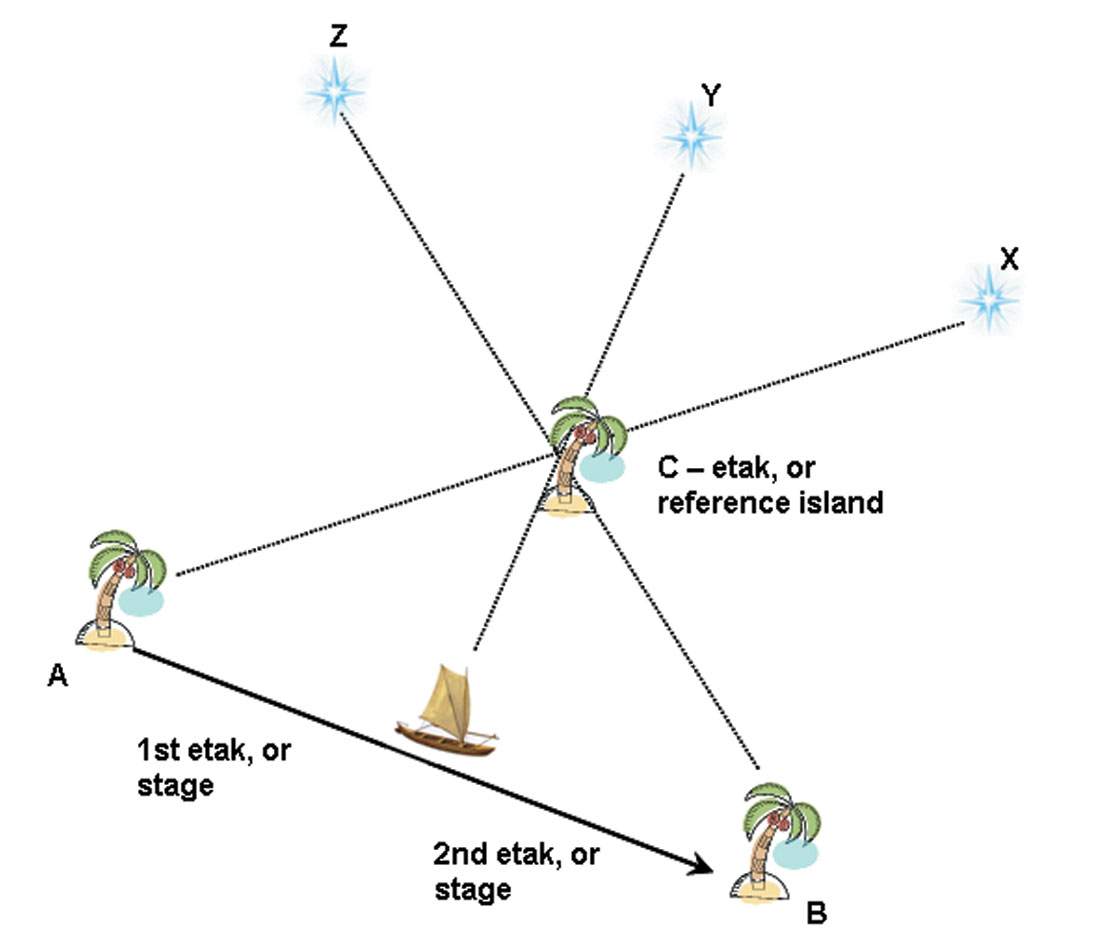
In the Carolinian etak system the home-center cognitive concept combines with the self-center methods such as the sidereal compass. In practice it means while the navigator continually conceptualizes his position relative to home and destination, he also divides his voyage into segments defined by the star bearings of a reference island (and of course maintains course direction as described in the first section). Figure 4 shows a simplified two-stage, or two-etak trip from island A to B. The first stage begins when, viewed from the boat, the island C lines up with star X on the horizon; it ends when the island lines up with star Y. The second etak ends when star Z lines up with the etak island. In practice a typical etak stage was in the order of 30 km long.
In this world view the stars can be thought of as fixed in the sky, as well as the boat’s position relative to them; it is the islands that conceptually move past in stages defined by the stars. In his book East is a Big Bird, Thomas Gladwin writes:
It is rather like sitting on a train and looking out the window. In your little world you sit and talk while the scenery slips by. In the distance there are mountains which for long periods of time seem to pace the train. Looking at them you are distracted by nearby houses which flash backwards between you and the mountains. The mountains are the stars and the houses the islands below.
The system of etak and its variants is based on the use of actual islands and star sightings, along well travelled Polynesian routes. However it can be taken to a level where actual islands or stars are unnecessary – the navigator conceptualizes travelling along segments defined by hypothetical etak sightline triangles, rather than our azimuth / distance vector system.
Probably the main reason that Europeans over the course of 500 plus years of contact with Polynesian people were unable to decipher, understand or glean much from their traditional navigational methods is that the etak-like methods at the heart of Pacific navigation are completely incompatible with European methods based on compass bearings, and absolute lats and longs. Neither side would have comprehended, understood, much less had anything to add to or learn from the other.
Finding landfall
Even if one accepts the fact that the traditional Polynesians were expert navigators, it seems a stretch, and well nigh impossible, that they could reliably and repeatedly find landfall after multiday or week open sea voyages – the Pacific is so vast and the islands so small. Upon a further look at specific aspects of finding a particular island and the methods the Polynesians employed, it becomes understandable. This topic can also be conveniently called “expanding the target”. If you have travelled by sea for 1600 km from Samoa to the Cook Islands, odds are you will miss your target destination of an island a few kilometres across. But if you alter your thinking to include ways to make the target bigger, to let you get close enough, then your chance of success will be much greater. This is what the Polynesians did, and the methods they used can be identified as follows:
- Island blocks
- Birds
- Clouds
- Swell patterns
- Luminescence
- Miscellaneous
Island blocks. The reality is that Pacific islands come in clusters. If one draws a 50km radius around each island, a realistic identification “halo” given line of sight (especially higher volcanic islands) and other less obvious indicators, islands become island groups become island “blocks” for landfall finding purposes. So right off the bat, Polynesian navigators were aiming for blocks of islands, not specific islands, confident that once they hit the island block, they could then adjust and find their final destination island nearby. For example, say you wanted to get to Oahu from Fiji, a huge distance. The Hawaiian island chain is approximately 1600 km long, and many of the islands are over 4000m high; that is actually a pretty big target. Once there a bit of a side trip to Oahu would be trivial.
Birds. A navigator would have had an expert knowledge of types of birds and their behaviours. Most important are birds that roost on land, but head out each day to fish, then return home in the evening. Terns and noddies fly a shorter distance out, say 30 – 40 km, and boobies and frigate birds fly further, up to approximately 50 km. All these birds will head away from land in the morning, and towards land in the evening, reliable indicators for seafarers looking for land.
Although not verified, there are historical references that some islanders kept semi-trained birds on board that they would use to guide them once they felt they were near landfall.
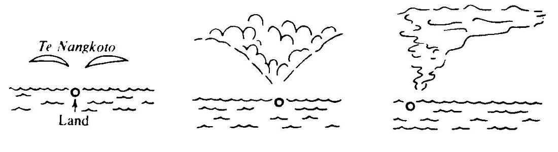
Clouds. Another area of natural science that was an important tool in the navigator’s land-finding toolbox was a knowledge of clouds. Differences in the colour, shape, and movement of clouds above land and sea were used as important indicators of landfall. Probably the primary factors at play are the differences in air temperature and humidity over land versus sea. Figure 4 shows a sketch Lewis drew illustrating an islander’s description of three different cloud formations indicating landfall. Clouds also tend to “catch” on high peaks, while away from higher elevations they will blow past. This phenomenon is well known to tourists hoping to catch glimpses of famous peaks such as Mount Hood SE of Vancouver, or Mount Assiniboine, West of Calgary – more often than not the peak is shrouded in cloud while the rest of the sky is clear.
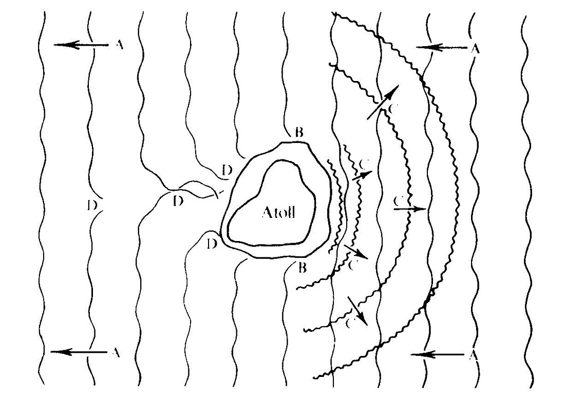
Swell patterns. This aspect of expanding the target will strike a chord in seismologists, or in fact any scientist familiar with wave theory. Polynesian navigators were expert at identifying and analyzing wave patterns caused by the presence of landforms within dominant ocean swells. Figure 5 neatly illustrates the three main phenomena used to identify the presence and position of an island – refracted swell (B), reflected swell (C), and shadow turbulence (D). Once these simple mechanisms were understood, apprentices were taught more complex patterns (i.e. interference patterns) associated with specific islands, and caused by the interplay of several islands and swell systems all combining. So the analysis of swell patterns could be used to generally identify landfall, or for more specific local use to identify known islands in situations like cloud covered darkness. It has been demonstrated that these methods can be used up to considerable distances out to sea. For example, one navigator was able to show Lewis the point at which he first detected the reflected swell from their target island, almost 60 km offshore, well out of sight of land.
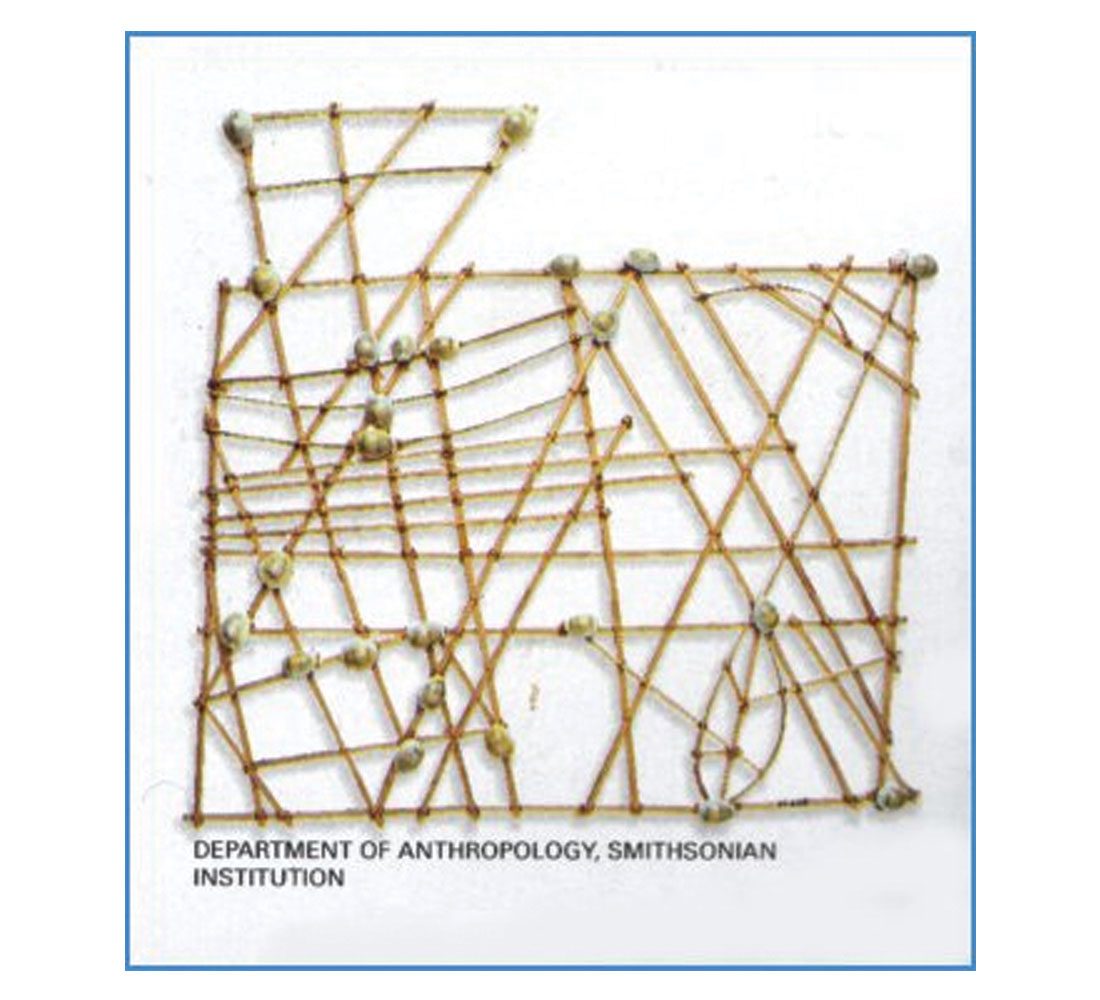
Lewis provides considerable detail on the use of swell patterns, and this is a topic worthy of deeper study on its own. The Polynesian stick and shell “maps” somewhat familiar to many are actually swell pattern charts used for instructional purposes.
Luminescence. This phenomenon is little understood, but has been verifiably observed. It is not the surface bioluminescence commonly seen around the world when surface water is agitated and micro-organisms give off light for a few seconds. This luminescence occurs up to 140-160 km offshore, deeper below the surface, and appears to radiate outwards from the distant land. The direction it appears to originate from indicates the direction of land. It is seen as a deeper form of flash, something like underwater sheet lightning. It is no longer seen once land is in sight. The nature of the luminescence changes with proximity to land; the navigators in the Santa Cruz Reef Islands distinguish between “distant-land lapa”, “reef lapa”, and “near-land lapa”, with faster, jerkier flashing seen closer to land, and slower flashing at a distance from land. It is speculated that this deeper form of luminescence is also coming from micro- organisms, perhaps stimulated by deep swell distortions created by the presence of islands and reefs.
Miscellaneous. There exists a variety of other target expansion techniques, poorly documented or veering into the realm of spiritual beliefs. These would include “smelling land”, knowledge of marine life outside of birds (e.g. some fish are found only near land), flotsam drifts as trace markers of land, deep reefs, and all sorts of beliefs that are hard to reconcile with scientific fact.
With humans around the world, when all else fails and we feel utterly adrift, the religious urges in us become stronger. The Polynesians were and are no different than us in this respect, and the boundaries between their navigational techniques, knowledge of natural science, cultural practices, and religious beliefs are blurred, and in many cases these four elements were tightly interwoven.
The ancient Polynesians’ navigational techniques are truly remarkable, and were based on a deep knowledge and understanding of natural phenomena that span the scientific fields of astronomy, meteorology, wave theory, biology and zoology, not to mention the many sophisticated techniques required to build, stock, steer and maintain long distance ocean-going craft. For this I consider them to be one of humanity’s great cultures, and distinct masters of science and technology in their time.


Share This Column