This edition is on British Columbia (B.C.) and Northern Canada. Both areas are famous for explorers, gold rushes, mining, and oil and gas.
This edition is on British Columbia (B.C.) and Northern Canada. Both areas are famous for explorers, gold rushes, mining, and oil and gas.
Early Explorers in B.C.
B.C. is famous for being explored by explorers such as Juan José Pérez Hernández (Spain) in 1774 and was claimed as a territory by Spain (Wikipedia, 2019a). In 1778, Captain James Cook sailed from the Sandwich Islands, up north and then northeast to explore the west coast of North America that was north of the Spanish settlements in California (Wikipedia, 2019b). He first made landfall on the Oregon coast, then came to Nootka Sound on Vancouver Island and traded with the First Nations living there. Cook then sailed up to Cook Inlet in Alaska by Anchorage and discovered Turnagain Arm and the Knik Arm at the north end of Cook Inlet. Turnagain is famous for its bore tide and many come to Turnagain Arm just to see it. Cook also charted most of the North American northwest coastline and determined the extent of Alaska. Cook sailed through the Bering Strait, sailing into the Chukchi Sea and headed northeast up the coast of Alaska until he was blocked by sea ice (Wikipedia, 2019b).
In 1792, George Vancouver sailed to B.C. and explored the Northwest coast. Vancouver named Mount Baker; Mount St. Helens; Puget Sound; Mount Rainier; Port Gardner and Port Susan, Washington; Whidbey Island; Discovery Passage; Discovery Island; Discovery Bay; and Port Discovery (Wikipedia, 2019c).
In 1793, Vancouver returned to British Columbia, proceeded further north, and unknowingly missed the overland explorer Alexander Mackenzie by only 48 days. Alexander Mackenzie had crossed overland to the Pacific 12 years before the Lewis and Clark Expedition, completing the first recorded transcontinental crossing of North America north of Mexico. Alexander Mackenzie had crossed over the Continental Divide (which separates the rivers flowing into the Pacific on the west side and the rivers flowing into the Atlantic on the east side) through Peace River, Alberta.
From when the North West Company and Hudson’s Bay Company (HBC) merged in 1821, B.C. was under HBC control. In 1858, just after a gold rush began, B.C. became a British colony and would join the Dominion of Canada on July 20, 1871, becoming the sixth province to join Canada. In return for entering Confederation, Canada absorbed B.C.'s massive debt, and promised to build a railway from Montreal to the Pacific coast within 10 years.
Geology – Terranes
British Columbia’s geology is unique compared to the rest of Canada because it is a series of terranes that were a succession of island arcs and assorted ocean-floor rocks that have been added to the continental margin by being sutured. Each terrane that is sutured has its own distinctive geologic history which is different than that from the surrounding areas. The suture zone between the terrane and the crust that it sutures to generally is a fault. The terranes had a wide variety of rock types, including metal-rich material derived from the depths of the crust (Mills, 2018).
British Columbia’s geology is part of the Ring of Fire: Pacific oceanic crust, chiefly the Farallon Plate, is here subducted under the North American Plate. This causes B.C.’s geology to be complex, with volcanoes; the Coast Plutonic Complex; and earthquakes and tsunamis.
Earthquakes and tsunamis
With the subduction zone being off the coast of B.C., there are earthquakes down deep which may trigger tsunamis (Figure 1).
An example of the threat of the possibility of a large tsunami off the coast of B.C. is the 1700 megathrust earthquake which occurred off the B.C. coast. This tsunami is recorded in First Nations lore from Vancouver Island to northern California and can be seen in their artwork involving a life-and-death struggle between a thunderbird and a whale that caused the earth to shake violently and the seas to wash away their people and homes (Meissner, 2015). This earthquake also caused a tsunami wave that had the height of a four-storey building which hit the Japanese coast (Meissner, 2015). The cause of this megathrust earthquake was/is two locked geological plates under the sea floor in the Cascadia subduction zone off Vancouver Island (Meissner, 2015).
For many Canadians it is hard for us to imagine the danger that lurks off our coast. When the big one hits the west coast, it is expected that a good sized chuck along the 1100 km Juan de Fuca Plate margin, stretching from British Columbia to Northern California, will slide beneath the North American plate, causing a piece of the Northwest coastline to sink by up to 2 m. The wave generated from this earthquake could reach heights of up to 25 m in the case of a 9.1 magnitude quake (Gragg and Hutchins, 2018).
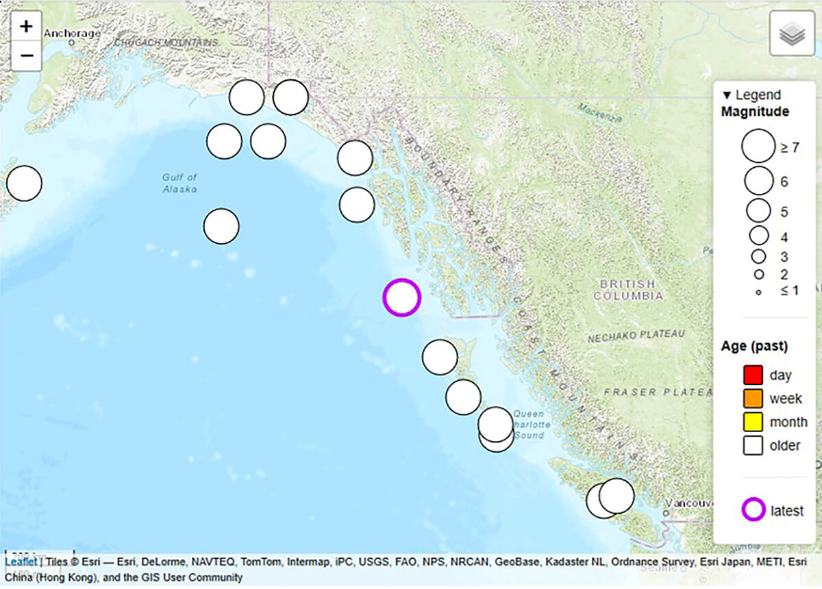
By looking into the geological record, it seems that about every 500 years there has been a megathrust earthquake in the Cascadia subduction zone, and they have been accompanied by tsunamis. Previous earthquakes are estimated to have been in 1310 AD, 810 AD, 400 AD, 170 BC and 600 BC (Wikipedia, 2019d). There is concern that there will be another megathrust earthquake soon since it has been 400 years since the last one. To help evaluate what is occurring, there are two undersea cabled observatories off the coast of Vancouver Island being operated by Ocean Networks Canada to monitor seismic activity (Casselman, 2019).
Volcanoes
There are more volcanoes in B.C. than I thought there were (Explore, 2015). It is strange when we learned about volcanic rocks, we did not talk about B.C. that much. Volcanic eruptions have a huge effect on the Earth. Not only do we have catastrophic damage from the explosion and magma coming out of the volcano, but they can have a direct effect on our climate.
We do know the last volcanic eruption in B.C., the Tseax eruption, was in 1780 - 240 years ago. This eruption killed about 2,000 people in northwestern B.C. (Canadian Press, 2019). We know this happened because the First Nations Nisga’a People put this in their lore, casting the eruption as the result of young people mistreating the life-giving salmon (Martins, 2019).
Gold and Gold rushes
When we think about B.C., we think about gold rushes, just like the gold rushes that occurred in California, Alaska and the Yukon.
The first gold rush in B.C. was the Haida Gwaii gold rush. It was started when a Haida man traded a 27-ounce nugget for 1500 blankets in Fort Victoria. A Hudson’s Bay Company ship was sent up to the southern part of Haida Gwaii soon thereafter, and the crew discovered a very high-grade vein (lode) deposit. This gold rush was quickly ended when the First Nation Haida Indians turned against the HBC and prevented further mining (WestCoastPlacer, 2019a).
In 1857, there was placer gold found in the Nicoamen River, which is a tributary to the Thompson River. This started some interest with about 1000 prospectors, but in 1858 the Fraser River gold rush began after an 800-ounce gold sample was sent from Fort Victoria to San Francisco for assay. Around 30,000 gold-seekers, many from the United States, rushed to the lower Fraser River to participate in this gold rush, which went up the Fraser river valley to Barkerville and Prince George (WestCoastPlacer, 2019a). This large influx of settlers prompted Britain to create a separate mainland colony called British Columbia.
The Golden Triangle
If you look at the map in Figure 2 you see an area called the Golden Triangle, and this happens to be the place where there were three gold rushes:
- Stikine Gold Rush of 1861. Nearly a thousand prospectors began flocking to the area after Buck Choquette’s discovery of placer gold where the Stikine and Anuk Rivers meet, near Fort Stikine, which is now Wrangell, Alaska (Wikipedia, 2019e);
- The Cassiar Gold Rush of 1873, which was in even more rugged country with huge mountains, glaciers and a very cold winter. High grade gold deposits were found in the extreme North of B.C.. The discovery was made in the summer of 1872 by Henry Thibert and Angus McCulloch on a creek that drains into Dease Lake. The creek was named after Thibert, who froze to death the following winter. Thibert Creek was very rich; in the first-year miners were getting up to three ounces to the pan (Wikipedia, 2019f; WestCoastPlacer, 2019b; Wrangall, 2019);
- The Atlin gold rush in 1898. Men were already headed to Dawson Creek on the Chilkoot trail and they began to venture off. Kenny MacLaren and Fritz Miller were two who decided to venture off the beaten path and headed east and found lots of gold. Soon people were not going to Dawson Creek anymore but headed across to Atlin (Atlinbc, 2019; WestCoastPlacer, 2019b).
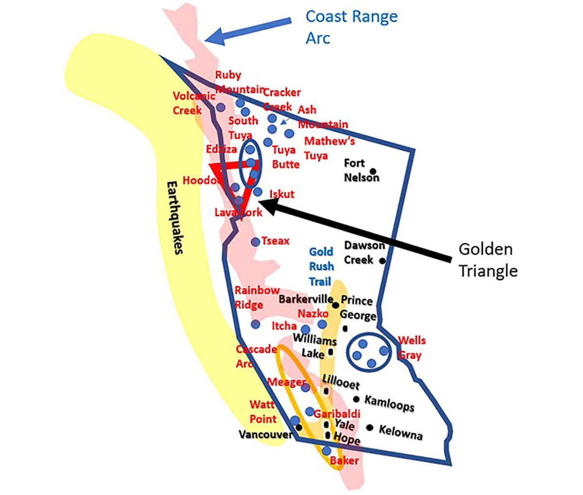
World class gold-rich deposits are associated with the Late Triassic and Early Jurassic intrusive suites in NW Stikinia. Metal deposits tend to be derived from hydrothermal systems (superheated water, circulating kilometers deep in the crust) which gathers metal atoms and then deposits the atoms in particular zones, creating concentrations of metals. The hydrothermal processes in the Golden Triangle lasted 10 times longer than most other geological systems like this, for perhaps 10 million years (Mills, 2018).
Prospectors
There is something unique about the prospectors who chased gold. They ventured into rugged areas and risked even their life and lived in terrible conditions in the bush in hopes of making it big one day. These prospectors can be compared to those who have worked the oil fields, or on the seismic crews, or even in the operators or service companies. We see individuals who are hoping to strike that one big prospect such as a Pembina or to make their $1 million by coming up with innovative and creative ideas like Canadian Hunter did when they developed the ideas around the Deep Basin.
There is something different about those who work in geoscience; there is a romantic aspect being able to coax from the earth its riches and trying to understand the mechanisms that drive these discoveries so that these discoveries are not just a stroke of luck but can be predicted.
We see the romanticism of prospectors and oil finders in the literature, and we are drawn to people that seek out the Earth’s riches – like an Indiana Jones. It seems geoscientists are even an integral part of NASA and one of the Apollo astronauts, Harrison Schmidt was a geologist.
For myself when I was much younger and very foolish, we used to drink late into the afternoon at a place like Hooters in Houston, telling the waitresses we were oil company men that worked offshore. There is this aspect of being somewhat intelligent and a bit of a bad boy at the same time. Some of the early prospectors and oil men even had cool names or nicknames like Red Adair, Buck Choquette, “Dry hole” Hunter. For me, folks just called me Schulte – kind of forgot what my first name was for a while.
There have even been songs books written by authors like Jack London, poems and songs written about prospectors like “The Cremation of Sam McGee”, and this piece of work has been performed as a song by Jonny Horton, or you can listen to the bone-chilling reading of the poem by Johnny Cash, and as you do listen to it you can almost feel what is going on.
B.C. Entry into confederation
Why B.C. wanted to enter confederation was for the following reasons (Canadian Encyclopedia, 2019):
- B.C. could take on debt to pay for the building of roads and other infrastructure;
- It would also provide a measure of security and ensure the continuation of the British nature of the colony;
- Threat of US annexing B.C. to link Alaska with American territories on the Pacific Northwest after the Alaska purchase.
The Alaska purchase saw the US purchasing Alaska from Russia for $7.2 million. This officially occurred on October 18, 1867, through a treaty ratified by the United States Senate and signed by President Andrew Johnson (Wikipedia, 2019g).
In the first half of the seventeenth century Russia had established a presence in North America, but few Russians ever settled in Alaska. After the Crimean War (1853 – 1856), which saw Russia being defeated by an alliance of the Ottoman Empire, France, Britain and Sardinia, Russian Emperor Alexander II began exploring the possibility of selling Alaska to the US, because Alaska would be difficult to defend from Britain and other countries in any future war (Wikipedia, 2019g; Wikipedia, 2019h).
Modern day B.C. – oil & gas exploration NE B.C.
In the late 1980’s I had a chance to work on the Halfway and Doig formations in NE B.C. I used this work for a project in the University of Calgary Geophysics 555 class that was taught by Dr. Rob Stewart. The project included a geological cross section and seismic interpretation. We were looking at the change in the wavelet due to the thickness of the sand. It is surprising that we were noticing these things and at the time I did not understand bright spots and AVO.
With horizontal drilling revitalizing areas, Petrel Robertson has looked at revitalizing the Halfway Formation as well as the Chinkeh Formation as alternatives to the lucrative Montney, which produces light oil and other natural gas liquids, like condensate.
The other area of interest in oil and gas for B.C. is the Horn River Basin, which is a shale gas resource. With the low cost of natural gas, currently not many are drilling in the Horn River Basin. It is hoped that with the building of a liquefied natural gas (LNG) plant on the north side of Campbell River, B.C. called Discovery LNG, it will use natural gas from the Horn River Basin (Bennett, 2018).
Proposed LNG on the west coast has gained large interest to access the Asian market and it is hoped that LNG could be sold to countries like: China, Japan, South Korea, India, etc. Natural gas when burned for electricity generation produces half the greenhouse gas (GHG) emissions coal does. Currently Russia, Australia, Indonesia, Malaysia, and Qatar are selling natural gas to China. With many countries trying to abide to the Paris Accord, it is hoped they will switch to natural gas, the demand for LNG will significantly increase, and the amount of GHGs emissions will significantly decrease.
Future for B.C.
It seems that with the melting glaciers in the Golden Triangle, it will increase mining activity in these areas.
In oil and gas, B.C. may have multiple LNG facilities to be able to export LNG to Asian markets. This will help companies that have been producing natural gas in the Horn River Basin NE B.C. and the Deep Basin, which spans both NW Alberta and NE BC. The activity in the Montney, which produces light oil and other natural gas liquids, like condensate, has been the focus of the oil and gas industry in B.C., but there are alternative formations like the Halfway and Chinkeh formations which produced oil in the past using vertical wells and which may once again be economical with horizontal wells.
Volcanic and earthquake activity has become a concern for public safety because of the stalled Juan de Fuca plate and the fear of a megathrust earthquake generating a huge tsunami like the one in 1700. It seems seismic activity on the west coast follows a 500-year cycle and it has been 319 years since the last megathrust earthquake. It is thought that the subsequent Tseax eruption in 1780 was the result of the 1700 earthquake. It is believed if a megathrust earthquake occurs that there will be an increase in volcanism and a rejuvenation of volcanoes in B.C.
We need through academic institutions such as University of British Columbia, University of Victoria, and Simon Fraser University to work on ground motion monitoring and predicting when earthquakes or volcanic activity will occur so people can be given early warning and be evacuated. These technologies can be distributed to the ring of fire to save many lives.
Mining in the North
The Yukon is world famous for the Klondike Gold Rush which occurred from 1896 to 1899. The Klondike Gold Rush brought tens of thousands of people to the previously barely known region and those four short years created numerous stories of adventure and riches that today live on as legend and define the remote territory.
There were many routes up to the Klondike gold fields such as (Peters, 2019):
- Chilkoot Trail which started a Dyea, Alaska and ended at Bennet, B.C. It is a 33-mile (53 km) trail through the Coast Mountains (Peters, 2019);
- Ashcroft Trail which began at the town of Ashcroft, which could be reached from Vancouver by way of the Thompson River. The trail passed through the Fraser Valley and Cariboo Country. From there, it followed the slash line of the Collins Overland Telegraph. The Collins Overland Telegraph was a $3 million dollar project which involved linking San Francisco with Moscow, Russia. The project was abandoned in 1867, but the slash line through the forest extended from Ashcroft to Teslin Lake, which is the headwaters of the Yukon River. The prospectors who made it there just went down the river to Dawson Creek (Peters, 2019);
- Stikine River which began as a steamboat ride up the west coast to the mouth of the Stikine River, in northern British Columbia. It followed the Stikine River to the town of Glenora, the site of an old Hudson’s Bay Company post and then joined the Ashcroft Trail (Peters, 2019);
- And the Edmonton route, which was in fact several routes. There was the river route, which was up the Athabasca River, down the Lesser Slave rivers, and over Lesser Slave Lake. Some of the other trails were overland and went through Fort Assiniboine. Others still took stampeders further west, from Lac St. Anne to Whitecourt to Grande Prairie to Fort St. John, B.C. (Peters, 2019).
Most of the gold in the Yukon is placer gold and requires gold panning. When I get older, I would like to hike along one of these routes, especially the Chilkoot Trail. I have had a connection with Alaska since I worked on the North Slope.
Yukon - oil and gas
Alexander Mackenzie first noted oil seeps during his exploration of the Mackenzie River in 1789, but it wasn’t until 1920 that Imperial Oil discovered a light oil-bearing formation at Norman Wells. In 1937 Imperial built a refinery there and during WWII it became important as a source for oil for the military in Alaska and Yukon (Wikipedia, 2019i). In 2016, the daily production was 8969 bbl/day (Statista, 2019a) and had a total accumulated production of 272 MMbbl (Statista, 2019b).
Mackenzie Delta
Exploration drilling of the Beaufort Mackenzie Basin (BMB) began in the mid-1960’s, and over the next 25 years 189 exploration wells, 130 onshore and 59 offshore, were drilled, resulting in the issuance of 48 Significant Discovery Licenses (Bergquist et al., 2004).
The current total estimate of potential recoverable reserves in the Beaufort Mackenzie Basin stands at 54 TCF offshore and 13 TCF onshore (NEB, GSC, CGPC) (Bergquist et al., 2004). There has been a plan to build a 1200 km pipeline down the Mackenzie Valley, but it has been on hold due to weak natural gas prices because of the natural gas glut caused by shale gas.
NWT and kimberlites
In 1991 two geologists, Chuck Fipke and Stewart Blusson, found evidence of diamond-bearing kimberlite pipes about 200 miles north of Yellowknife, Northwest Territories. This began the diamond industry in the north. By 2006 there were three major mines were producing over 13 million carats of gem-quality diamonds per year. This placed Canada as the third-largest producer of diamonds in the world (King, 2019).
It is not easy to mine for diamonds in the north. There are essentially three problems (King, 2019):
- Their very remote location. Like most places in the north, the mines can only receive overland freight during a short "ice road" season that lasts between six and ten weeks. If the supplies are not delivered then, then they must be delivered by air. The mines up north must also have housing and full facilities for all their employees because they are all located away from towns or settlements;
- Cost of labor;
- And as the open pit mines are being depleted, companies must continue working the ore body using underground mining, which is 50% more per ton.
Apology
My apology that there was no Mid-October Recorder. It was essentially a combination of factors that caused it:
- Lack of material;
- Lack of announcements from the committees;
- My starting a new position as a consultant and having to start up my company.
Putting together the Recorder takes a lot of effort and we really need our members’ help on this. We ask that if you are on a CSEG Committee to send reports to us so that our membership can understand what is going on with your committee. We also need your help to find articles when we have focus topics so we can publish them in the Recorder. It is hard to cold-call people.
I will be leaving as Chief Editor for the Recorder. If you are interested in the role please let us know through the CSEG office. I need to pursue this opportunity as a consultant to help my new employers to drill successful wells.
The Recorder really is one of the forms of communication we have that educates and lets everyone know what is going on.
Thank you and a Merry Christmas!!!!


Share This Column