In January 2010, BP signed an agreement to explore and appraise the 7,200 sq km Risha Concession, located in Eastern Jordan, bordering Syria, Iraq and Saudi Arabia. A short Exploration and Appraisal period mandated acquisition of 5000 sq.km. of high fold 3D data, to be completed within the first 18 months. This in turn required acquisition rates and costs (per sq km) typical of marine seismic surveys, and represented a challenge best addressed using BP’s simultaneous source technology, DS3. Distance Separated Simultaneous Sweeping (DS3 or DSSS) is a sim-source technology first developed and implemented by BP in 2008 Armed with this technology, the crew acquisition rate steadily climbed to a peak rate of 1,500 sq.km. per month with a record rate of 59 sq. km. per day, producing a state of the art, high fold, wide azimuth, dataset.
The survey objective was to acquire a high quality (> 1200 stack fold at 7km mute-offset), wide azimuth, 3D survey suitable for structural interpretation, attribute analysis and anisotropy studies. Data quality in Risha is affected by a complex near surface with significant karstification causing a high degree of scattered noise which masks reflection data (nearly invisible reflectors). Previous 3D vintages are challenging to interpret, fail to adequately image the Ordovician reservoirs, are characterised by poor signal to noise, lack resolution, and continuity of key reflectors.
The 3D design used a 22 line recording patch, with 600m receiver line spacing. The nominal receiver line was 27.5km long, resulting in 12,100 traces recorded with each VP, using an active spread spanning from 350 sq.km to more than 490 sq.km. Receiver groups were spaced 50m apart and a simple linear array of 6 geophones was intended to further assist line crew productivity. Source lines were positioned 50m apart, parallel to receiver lines with a 50m VP interval, creating both long source lines to maximise vibrator efficiency and a fully sampled source grid (50m x 50m) to attenuate scattered noise and create a high fold dataset.
Eighteen active vibrators were operated in three sets of six vibrators. Individual vibrators were situated on one of the twelve source lines between the centre pair of receiver lines in the active recording patch, while the three sets were spaced 11km (or greater) apart, a requirement of the DS3 technique.
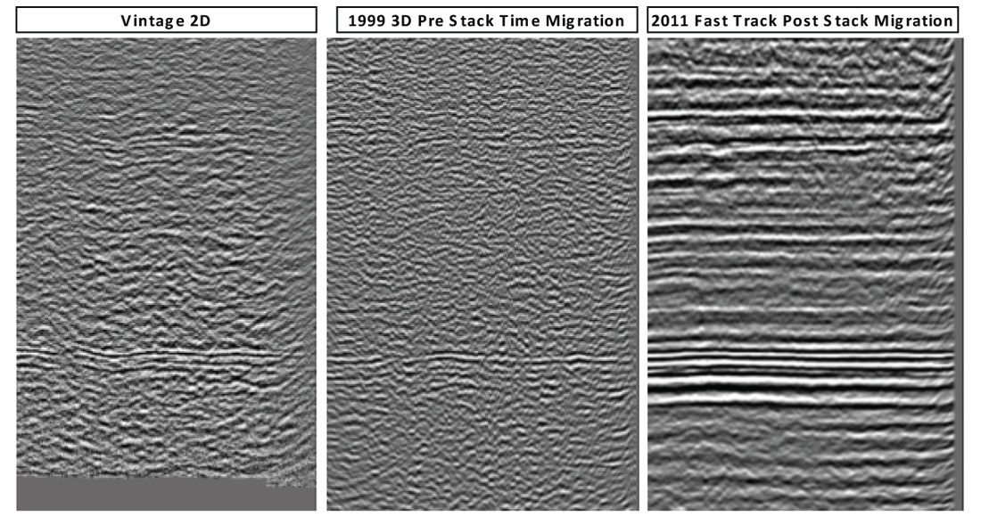
Figure 1 compares 2D vintage and 1999 3D seismic (156-187 fold, narrow azimuth) data with 2011 DS3 fast track. Overall, even with limited processing, the newer dataset shows significant improvements in data quality in terms of S/N and reflection continuity throughout the section. The speed of acquisition, combined with the ability to process the data quickly, without the requirement for simultaneous source separation software, has helped put high quality image volumes in the hands of the interpreter far in advance of the deadlines for well planning.


Join the Conversation
Interested in starting, or contributing to a conversation about an article or issue of the RECORDER? Join our CSEG LinkedIn Group.
Share This Article