Innovative. Creative. Committed. These words have defined Canada’s oil sands industry for decades and are what drives people and companies to find new ways to make the industry more competitive and to reduce the environmental footprint.
Despite the high degrees of change and uncertainty facing the world because of Covid-19, this work does not stop. As eyes are increasingly focused on Canada’s oil sands footprint, a group of leading oil sands companies have been working together since 2012 through a unique collaboration called Canada’s Oil Sands Innovation Alliance (COSIA). One of COSIA’s current aims is to identify new and emerging opportunities to collect high-quality seismic data in a way that preserves contractor safety while significantly reducing – or even eliminating – the environmental footprint associated with exploration.
It is a tall challenge, but if anyone is up to it it’s the national and international geophysical community. And this fall, innovators will have their opportunity to showcase their brightest and most creative ideas during an exploration tools workshop and pitch session, hosted by COSIA.
The Context
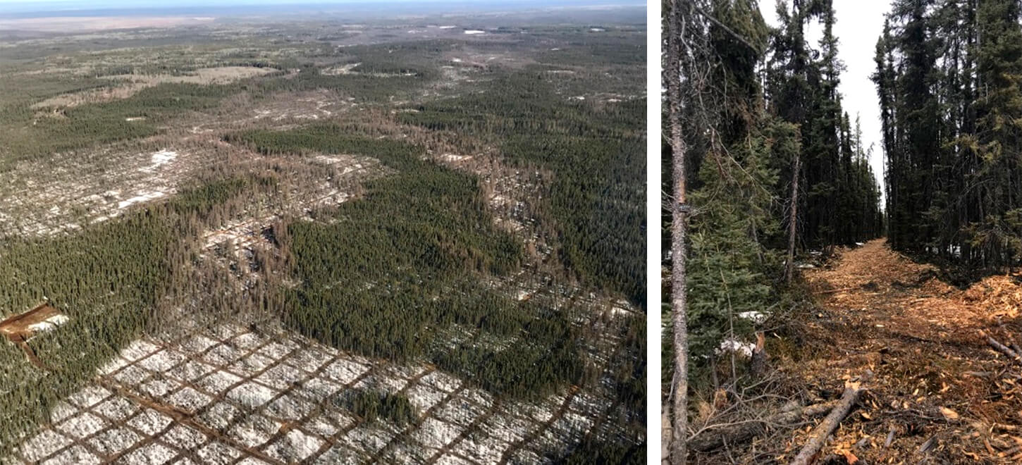
It’s likely no surprise to Canada’s exploration geophysicists that seismic exploration in Canada’s boreal forest is a critical first step in the discovery and delineation of future oil and gas reserves. Successful resource recovery requires detailed subsurface information about the volume, location and quality to guide business investment decisions. Seismic exploration requires a network of cut or mulched seismic lines (Figure 1) which supports the efficient acquisition of subsurface data.
The network of cut lines across often difficult terrain has benefited the industry in that it provides a predictable template for estimating acquisition costs, allows for the collection of high-quality seismic data at depth and, most importantly, expedites safe and quick movement of individuals in the event of an injury or medical emergency (Larson et al. 2020).
Unfortunately, acquiring seismic data also results in significant disturbance of the boreal forest. Approximately half of the surface footprint of an oil sands in situ project is composed of seismic lines according to the Hague (2009) regional industry estimate. While natural disturbance (e.g. forest fires, pests), climate change, forestry and municipalities (e.g. roads, buildings) all contribute to boreal forest disturbance (Environment Canada 2012), the leading human-driven contributor is seismic lines (Arienti et al. 2009; Schneider et al. 2010) with densities up to 83 km/km2 (Filicetti et al. 2019; Suncor direct measurement).
Past seismic acquisition programs also continue to impact the boreal ecosystem dynamics today. Seismic lines and other human-caused habitat changes lead to forest canopy changes which can result in an increase in deer (Odocoileus spp.) densities that flourish in altered habitat and subsequently wolf densities (Latham et al. 2011). Poor tree regeneration on old seismic lines (Filicetti et al. 2019) enables lines to be used as travel corridors for wolves, resulting in increased encounters with and predation on, the threatened woodland caribou (Rangifer tarandus caribou) (Dickie et al. 2017). New, narrower cutting practices today still result changes to forest vegetation adjacent to lines (Dabros et al. 2018), and increased methane emissions (Strack et al. 2019).
Towards lower-impact seismic exploration practices
Over time, industry innovation has reduced seismic line widths from 8 metre wide clearings to 2-3 metre wide lines today, referred to as ‘low-impact-seismic’ (LIS). Today, these cleared lines support the safe passage of moving source equipment and people during the winter that either (i) directly delivers seismic energy to the earth by contacting the ground (e.g. vibroseis) or (ii) drills holes (normally 3-10 metres deep) to position dynamite explosives into the earth to create seismic energy upon detonation. COSIA member companies have established an Innovation Opportunity to help incent the next ‘step-change’ in seismic footprint reduction with the potential to further enhance conservation practices during seismic exploration.
“Member companies of Canada’s Oil Sands Innovation Alliance (COSIA) have established a Land Innovation Opportunity to help incent the next ‘step-change’ in seismic footprint reduction with the potential to further enhance conservation practices during seismic exploration.”
The COSIA Land Innovation Opportunity
COSIA is an alliance of oil sands companies working with global scientists, academics, and innovators to support sustainable Canadian energy while delivering accelerated environmental performance improvement in the four key Environmental Priority Areas (EPAs): tailings, water, land and greenhouse gases. One area the COSIA Land EPA is focused on is increasing land-use efficiency and reducing the operating footprint intensity and impact of in situ operations on the land and wildlife of northern Alberta, Canada. In keeping with this focus, COSIA has identified an Innovation Opportunity in relation to reducing the footprint associated with seismic exploration activity. The goal is to:
Investigate alternative seismic exploration techniques that would help lead us towards zero land disturbance for in situ projects.
Beginning in 2017, global innovators were invited to submit a potential solutions to COSIA’s Environmental Technology Assessment Portal (E-Tap) at http://www.cosia.ca/initiatives/etap. The Innovation Opportunity called for technologies and techniques that eliminate or reduce tree clearing associated with exploration in the boreal forest and in particular within the in situ oil sands region of northern Alberta, Canada. For more background information see the COSIA Land Innovation Opportunity here.
“The race is on to find and develop not just one, but a series of seismic tools, techniques or best practices that approach zero land disturbance…”
A Set of Seismic Toolbox
The race is on to find and develop not just one, but a series of seismic tools, techniques or best practices that approach zero land disturbance so member companies of COSIA can select from them and apply the most appropriate one(s) to meet each individual in situ oil sand project’s needs. This means identifying, developing and testing multiple new ideas simultaneously. Some may work and some may fail, but the intent is to get many seismic tools that approach zero footprint to the commercial application stage. Work is already underway.
A report on the state-of-science for seismic technology footprint has been completed (Larson et al. 2020), some technology concepts have been advanced to the pilot phase by COSIA member companies and a seismic exploration tools workshop is planned in fall 2020. For more details see below.
A Review of Exploration Tools and Techniques
In 2018, COSIA partnered with Fuse Consulting Ltd. (Fuse) and RPS Energy Canada Ltd. (RPS) to develop A Review of Exploration Tools and Techniques to Support COSIA Land Challenge: Near Zero Footprint Seismic Exploration (“Review of Exploration Tools and Techniques” report) (Larson et al. 2020). This report focused on uniting the ecological and geophysical aspects of seismic lines and multidisciplinary experts within a single project to identify opportunities to advance towards zero land disturbance seismic exploration (Larson et al. 2020). The project collated ideas using the following methods:
- Interviews with contractors, energy and petroleum company representatives;
- A global literature review of available and emerging technologies;
- A workshop with geoscientists and environmental scientists from COSIA member companies; and
- A qualitative assessment of the potential impacts of new seismic technologies on acquisition cost, seismic data quality and health and safety (Larson et al. 2020).
The comprehensive literature review identified a number of opportunity categories for approaching zero footprint seismic, such as:
- Modify and miniaturize existing methods – Shrink the size of equipment and practices used today during seismic data acquisition.
- Leave the ground entirely by going airborne – Move seismic survey equipment from the air.
- Leave the ground entirely by going underground – Install all equipment in existing production wells so existing or planned production well site areas are being re-used for multiple activities.
- Use alternative seismic sampling theory – Measure seismic waveforms differently (Larson et al. 2020).
To understand the current state-of-science on advancing towards zero land disturbance seismic exploration see the “A Review of Exploration Tools and Techniques to Support COSIA Land Challenge: Near Zero Footprint Seismic Exploration” report by clicking here.
A Call for Innovation and Creativity
COSIA member companies are committed to the vision of funding, testing, and developing new technologies to approach zero footprint seismic activities. To encourage the development of new technologies and new ideas, exploration geophysicists are invited to participate in two opportunities this fall. First, an exploration tools workshop in which emerging innovations, tools and approaches from around the world will be showcased via an online workshop. Then, two weeks later, geophysical contractors and innovators will have the chance to pitch their ideas to a group of COSIA member company representatives who will evaluate and select the top few ideas for discussion about future field testing and development opportunities.
The workshop will be take place on November 17 and 18, 2020 and will feature industry speakers, innovative presentations, networking opportunities.
We look forward to further engaging with Canada’s exploration geophysicists at these upcoming events!
To learn more about the November 17 and 18, 2020 COSIA Exploration Tools Workshop click here.

Acknowledgements
We thank Christine Forfar, Cathy MacKinnon and Darryl Parry for providing comments on the paper.


Join the Conversation
Interested in starting, or contributing to a conversation about an article or issue of the RECORDER? Join our CSEG LinkedIn Group.
Share This Article