Introduction
High resolution Magnetic (HRAM) data has been flown over most of the active sedimentary basins of the world. These data has been widely used for exploration and exploitation of both frontier and mature basins. The objective of this paper is to show case studies where HRAM data interpretation has made a valuable contribution to exploration, primarily in the Western Canada Sedimentary Basin (WCSB). Examples of where HRAM data interpretation could have an impact on the new resource plays are also given.
An experimental HRAM survey flown in 1991 over the deformed belt of the North Slope of Alaska was one of the earliest HRAM surveys flown for oil and gas exploration. The survey was flown using a nominal ground clearance of 500 feet with a line spacing of half a mile. The data collected showed that such surveys substantially improved the mapping of basement structures in this remote area but, more importantly, demonstrated the ability of HRAM data to depict the magnetic signature of sedimentary structures that are detached from the basement. The magnetic data from this survey, particularly the imagery of the Umiat anticline (Figure 1), changed the way industry viewed the application of magnetic surveys for hydrocarbon exploration from a regional reconnaissance tool to a prospect scale exploration tool. Figure 1a, shows a magnetic image that was filtered to extract the high frequency content of HRAM data from the Brooks Range fold belt of the North Slope of Alaska. It reveals the fault line traces of major thrust faults and individual folds. Figure 1b, is a close-up look at the eroded core of the Umiat anticline. The anticline is imaged as a series of concentric, high frequency magnetic features, while the satellite imagery (Figure 1c) reveals that the anticline is obscured at the surface by glacial and fluvial glacial sediment.
Several years after the Umiat study, an HRAM survey over the Green River Basin of Wyoming demonstrated the ability of HRAM surveys to detect the subtle expressions of deep-seated basement faults in relatively undeformed mature basins. Magnetic images from this survey show the fault line traces of several strike slip faults that form the boundaries of the giant Jonah gas field (Figure 1d and e). The magnetic data interpretation correlated well with faults that were interpreted from 3D seismic and well data (shown in blue, after Cluff and Cluff 2004).

The success of the Alaska survey in mapping highly deformed structures in frontier areas and the Jonah field survey in detecting deep seated structures in mature basins opened the door to a new era of HRAM surveys which were flown over most of the active sedimentary basins in the world. This era was also complimented by the development of new processing and interpretation techniques (Nabighian et al., 2005, Hood, 2007). The petroleum industry in Canada as well as the Geological Survey of Canada (GSC) was quick to adopt this new technology by initiating and sponsoring the collection of many none exclusive surveys throughout the entire sedimentary basins of western Canada.
Four case studies representing compelling examples of the contribution of HRAM data to exploration in WCSB are presented. They cover a wide range of exploration activities including: near surface mapping of complex detached sedimentary structures of the fore foothills region in the North West Territories (NWT), mapping of basement faults and related hydrothermal dolomite (HTD) reservoir trends in north east British Columbia (NEBC), detection of basement structures that exerted control on the development of “sweet spots” and “preferred trends” in the Montney/Doig resource plays, and recognition of basement structures that exerted control on the development of the emerging Cardium light oil play in the Pembina area.
The Central MacKenzie Valley Area
The central Mackenzie Valley lies within the North West Territories north of Fort Simpson and south of the Mackenzie Delta. In 1994, after a long hiatus, the federal government invited the oil industry to participate in a new round of exploration. This initiative was complimented by the collection of seismic data, high resolution magnetic data, gravity and geochemical surveys which were made available at nominal cost. Thirty six wells were drilled and used to test several new exploration concepts in different formations ranging from the basal Cambrian through to the lower Cretaceous. New discoveries were made in the Colville area and in the Summit Creek Mountains. The Summit Creek discovery is particularly interesting because the initial recognition of the prospective structures was made through the analysis of HRAM data (Figure 2).
In 2003, IITech conducted an integrated structural interpretation for Northrock Resources using HRAM data collected by the GSC over the Central Mackenzie Valley (Figure 2a). This project was designed to augment an ongoing evaluation of a large exploration program conducted by Northrock and its partners. The use of HRAM data led to the interpretation of several large thrust faults and structural trends not previously recognized. It was inferred from this that these faults may have produced prospective structures. Two 2D seismic lines were collected by Northrock and its partners across these trends which confirmed the presence of two thrust fault-bounded deep-seated anticlines on the south west slopes of Summit Mountain (Figure 2b). These anticlines were nicknamed Betty and Wilma. Summit Creek B-44 (over Wilma) was drilled in 2004 and produced 20 MMCF/D of gas and 6,300 barrels of condensate a day from two Devonian reservoirs. This well represents the first hydrocarbon discovery in the Central Mackenzie Valley since Norman Wells was first drilled, in 1919. A second discovery, over “Betty” (Stewart Lake well, Sah Cho L-77), drill stem tested at 5MMCF/D from a Cretaceous reservoir.
As illustrated in Figure 2c the Summit mountain area contains several thrust faults that were partially recognized by surface geological mapping. However, the full extent of the thrusting and the potential development of prospective structures were only revealed after the collection of HRAM data in this area. The analysis of the HRAM data showed the presence of several structural features that trend parallel to the mountain front. This trend consists of a series of thrust faults that exhibit branching and interlocking patterns. The HRAM data also shows the presence of high frequency concentric features that may reveal the presence of buried and obscured anticlines. Figure 2b, shows the stacked relationships between near surface structures that were identified by surface data and HRAM imagery and subsurface structures that were identified by seismic and well data.

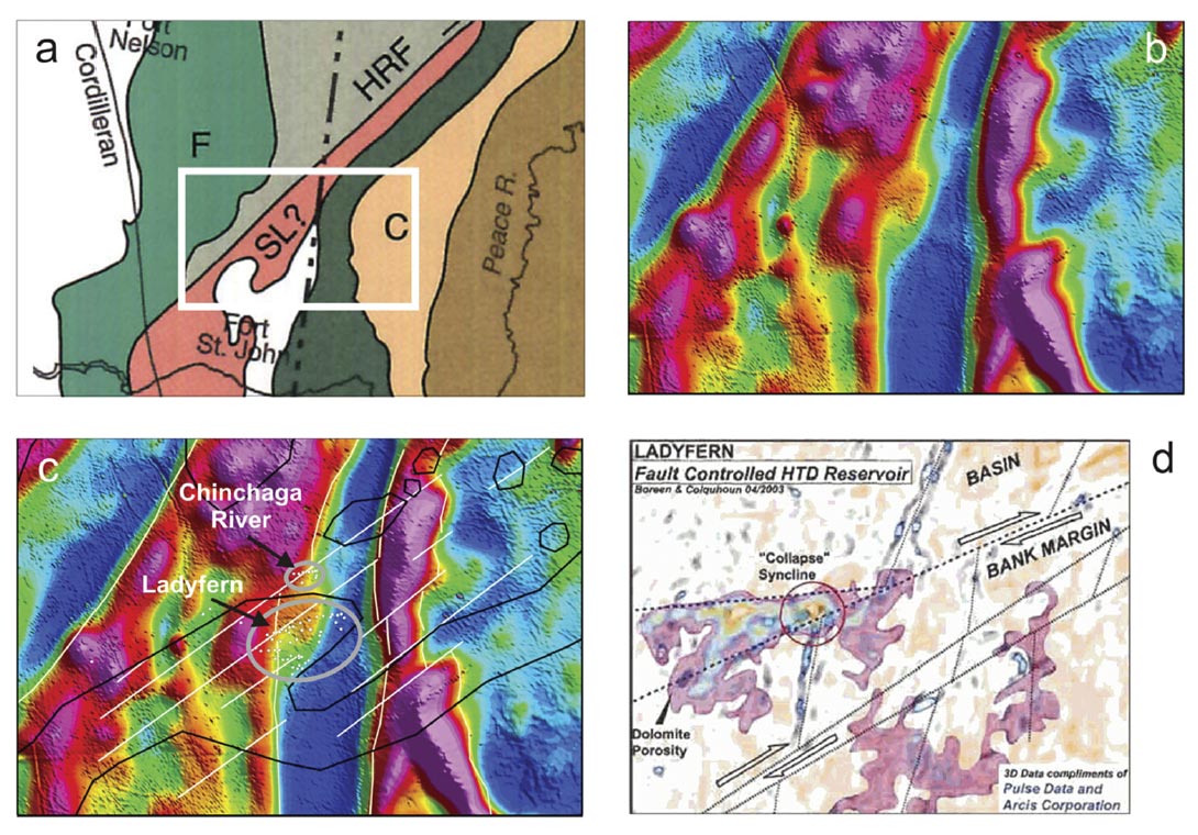
The Discovery of Lady Fern in NEBC
In early 2000, Apache Canada Limited along with farm-in partners Murphy Oil Corporation and Beau Valley Canada drilled a deep test well in the Lady Fern area of NEBC. This well led to the discovery of a major gas pool which was responsible for reversing the decline of natural gas production in Canada at that time. The discovery was made along a series of basement faults that precipitated the development of a highly productive HTD reservoir. The discovery of the field confirmed the viability of using wrench fault based HTD exploration model that was championed by Davies (1993), Morrow and Aulstead (1995), Reimer and Teare (1991) for prospecting other carbonate units in the WCSB. This discovery also reaffirmed the value of using HRAM data as prospecting tools.
The Ladyfern field is located within the Great Slave Lake shear zone (GSLSZ), which is a major north east trending Pre- Cambrian feature (Figure 3a). The lithological boundaries within the GSLSZ produce profound expressions on HRAM data (Figure 3b). The field was discovered within a north east trending “nose” of the Slave Point bank edge (Figure 3c). The location and orientation of the Slave Point “nose” as well as the producing wells appear to be related to the presence of a suite of strike-slip faults that cut and offset the structural grain of the GSLSZ. The HRAM data over the Ladyfern discovery provide an excellent example of a basement offset. The relationship between basement structure trends and the development of HTD reservoir is nicely illustrated by the dolomite porosity trends from 3D seismic (Figure 3c) (Boreen and Davies 2004).
Exploitation of the Resource Plays in the WCSB
The recent emergence of unconventional plays provides the geosciences community with new challenges. Geologists and geophysicists accustomed to mapping conventional hydrocarbon traps are now being asked to contribute to the development of homogeneous and unstructured reservoirs. As these resource plays are being developed, it becomes clear that they contain “sweet spots” which are difficult to detect with conventional exploration tools. This provided us with an opportunity to investigate using HRAM data the relationships between basement structures and the presence of “sweet-spots” and “preferred trends” within these unconventional plays. Our studies have shown that deep-seated basement structures apparently produce geological conditions that result in the development of “sweet spots” within unconventional plays (e.g., increased fracturing, heat flow, fluid migration, accommodation space, or reservoir thickness). Examples from studies of active resource plays from the WCSB, that demonstrate how HRAM data can be used, are presented here (Berger et al, 2008, 2009, and 2010).
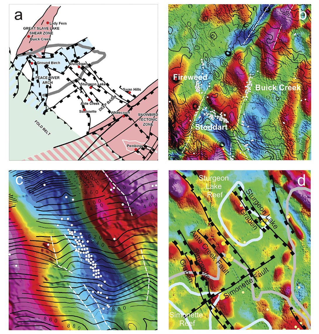
A generalized tectonic map of the Peace River Arch and the Deep- Basin area is shown in Figure 4a. This area is dominated by the presence of two regional scale, north-east trending basement structures; the GSLSZ and Snow Bird Tectonic Zone both with prominent magnetic signatures. A series of northwest trending, high angle normal faults have been mapped across the entire region using magnetic data.
Graben features of the Dawson Creek Graben Complex that developed along the crest of the Peace River Arch are also shown. The region hosts three active resource plays: 1) the prolific and well established shale gas play of the Montney-Doig formations which is centered on the Peace River Arch and the GSLSZ area, 2) the emerging oil shale play of the Nordegg Formation which is centered around the Deep Basin and the southern edge of the Peace River Arch and 3) a tight- sand oil play of the Cardium formation which is located along the Snow Bird Tectonic Zone near the Pembina oil field.
Figure 4b is an example of basement structural control on the development of major Doig pools within the GSLSZ. Cretaceous Bluesky formation structural contours are overlain on residual HRAM data, with locations of several major Doig fields shown. The Doig fields are largely developed along the edges of magnetic features that represent linear basement elements of the shear zone suggesting that basement structures exert control on the distribution of the Doig reservoir. The correlation between trends observed on the Bluesky structure map and those observed on the HRAM data strongly suggest that the shear zone was active during Cretaceous time, possibly in response to the formation of the thrust belt to the west.
Figure 4c illustrates the relationship between basement structures and the location of the giant Groundbirch Montney/Doig gas field. The HRAM residual magnetic image is overlain by Bluesky structural contours and Doig wells. The Groundbirch field is located along a major northwest trending basement feature interpreted to represent a small “failed arm” of the Dawson Creek Complex. Note however, that the effect of the basement features on Cretaceous structures is subtle suggesting that this structural element was more or less dormant during Cretaceous time. Figure 4d illustrates the relationship between basement structures, Devonian reefs, and the location of “sweetspots” in the emerging Nordegg oil shale play. The interpretation of the magnetic image, which is centered on the Ante-Creek reef area, show that the ‘sweet-spot” of this play is located at an intersection of a basement fault with linear edges of the Devonian reef. This example illustrates how the interpretation of HRAM data can lead to the development of an inventory of new leads for this emerging oil shale play.
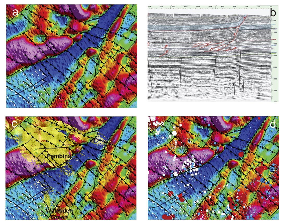
The final example for this article is taken from an HRAM study of the southern edge of the Deep Basin Figure 5. This area contain several active and mature resources plays which include; the new Cardium oil play of the Pembina Field, the HTD gas play of the Banff Formation in the Ferrier area as well as the mature resource gas plays of the Rock Creek and Ellerslie formations. The interpretation of the HRAM data of this region reveals the presence of three distinct structural features, 1) northeast trending lithological boundaries of the Snow Bird Suture Zone (SBSZ) which dominate the basement magnetic signature, 2) northwest trending normal faults that cut and offset the lithological boundaries of the SBSZ and 3) several buried thrust faults and related “tear faults” in the southern edge of the fold belt which manifest as high frequency signals in the HRAM data. A north east trending regional seismic line from this area (Figure 5b) picks up the northwest trending normal basement faults and shallow thrust faults. The basement faults act as structural ramps for the development of the shallow thrust faults. The deep seated basement features associated with the north east trending lithological boundaries of the SBSZ are very subtle and extremely difficult to detect with 2D seismic data.
The control of basement structures on the development of the Cardium play is illustrated in Figure 5c. The southern edge of the main Pembina pool is terminated along a major basement feature that reflects a major lithological boundary of the SBSZ. The northern “arm” of the Pembina pool is controlled by northwest trending normal faults. Figure 5d shows the control of basement and sedimentary structures on several of the unconventional gas plays. The “sweet spots” in the Rock Creek and Ellerslie formation are located at intersections of basement structures mapped with HRAM data. The HTD Banff play at Ferrier is related to the structural fabric of the thrust belt. It is interesting to note here that the Deep Basin area has been traditional known to be a purely stratigraphic plays with little or no demonstrable structural control. The analysis of the HRAM data clearly contradicts this notion.
Closing Remarks
The use of HRAM data brings new and exciting tools for mapping basement and near surface sedimentary structures of both mature and frontier basins. HRAM surveys which are now available over most of the active sedimentary basins of the world are being used to establish the tectonic framework of the basins. They are important when assessing the influence of basement structures on the development of different hydrocarbon plays and when mapping and identifying the structural styles of sedimentary structures. These surveys can also be used to define “sweet spots” of unconventional oil and gas plays. The technology is benefiting from the availability of inexpensive processing and image enhancement tools which are easy to implement and can be incorporated into other standard processing platform of seismic and well data.


Join the Conversation
Interested in starting, or contributing to a conversation about an article or issue of the RECORDER? Join our CSEG LinkedIn Group.
Share This Article