The development of multibeam mapping, (swath mapping), has been one of the most significant technological advance for marine geologists over the last 15 years. Traditional hydrographic surveys with single incidence echo sounders relied on a grid of tracks, between which data was interpolated. Multibeam systems replaced the Single transducer with 60-120 beams, simultaneously collecting data from a broad swath, allowing digital terrain models of the seafloor to be produced, equivalent to photogrametric and satellite imagery on land.
Through a collaborative partnership between the Canadian Hydrographic Service, the University of New Brunswick, the Geological Survey of Canada (GSC), and industry, Canada has become a leader in the development and application of multibeam tools. In the GSC multibeam has revolutionized geological mapping on the continental shelf and our understanding of ice margin processes, geohazards and sediment transport. In Atlantic Canada, multibeam has assisted the exploration for offshore hydrocarbons by extending bedrock mapping offshore and by identifying surface expression of gas seeps. For the SOEP development, multibeam surveys were completed of the production sites and pipeline corridors. Collaborative research between the GSC, SOEP (and Mobil) has been instrumental in mapping large scale bedforms and determining bedform stability. On the Grand Banks repetitive seafloor surveys have been used to determine the frequency of iceberg scouring. Beyond the immediate application to developing offshore fields multibeam imagery has been used to map submarine landslides, detect subsidence, and map submarine channels and relict drainage systems. Multibeam mapping has added a new dimension to offshore surveys, however other traditional tools such as sidescan sonar and high resolution seismics are still essential; multibeam imagery provides the framework within which these surveys can be planned. As exploration interests turn to the deeper water of the continental slope, regional multibeam surveys will be critical in providing regional base maps and in identifying geohazards.
What is Multibeam Bathymetry and How Do We Use It?
Multibeam bathymetric survey techniques provide a rapid means of determining the morphology and nature of the sediments on the sea floor or lake bottom. As shown in the Figure 1, a multi-element transducer provides many (30-150) individual soundings of the water depth and echo strength for each ping. Automatic sea floor tracking programs determine depths and echo strengths for each transducer element, correct for transducer motion, and calculate a geographic co-ordinate for each individual sounding.

A wide swath (up to 7 times the water depth) can be surveyed in a single pass through an area. Survey lines are spaced to provide overlapping coverage of the seafloor. The data are used to generate high-resolution images which contain information about the morphology of the seabed. These techniques have detected features that are not always detected by ordinary bathymetric soundings.
Digital multibeam bathymetry has become the primary reconnaissance mapping tool used by the Geological Survey of Canada for marine geology surveys. Multibeam bathymetry and backscatter intensity data a recollected as the first stage of multiparameter geophysical surveys. The multibeam bathymetric data are used to create shaded relief images that depict sea floor morphology. These images are used to interpret features on the sea floor such as channels, areas of bedrock outcrop, small scale bedforms, rocks and other small objects. In some areas it has been possible to map changes in bedrock geology based in the change in sea floor character over the different rock types. Acoustic backscatter intensity measurements are used to determine the general distribution of coarse and fine sediments. The maps and images form the basis for the preliminary interpretation of geological processes and features, and are used to plan subsequent surveys using higher resolution sidescan sonar and seismic reflection systems to better define features identified on the multibeam data.
At the Geological Survey of Canada (Atlantic) three multibeam survey systems are currently utilized: the Simrad EM100, the Simrad EM1000, and the Simrad EM3000.
- The Simrad EM100 is a 95 kHz multibeam echosounder capable of mapping the seafloor at depths between 5 and 600 metres below the transducer.
- The Simrad EM1000 is a 95 kHz multibeam echosounder capable of mapping the seafloor at depths between 3 and 1000 metres below the transducer.
- The Simrad EM3000 is a 300 kHz multibeam echosounder capable of mapping the sea floor at depths between 3 and 70 metres below the transducer.
Bathymetry data collected with these systems are processed to remove the effects of vessel motion, corrected for errors due to tides, and geographically referenced. The data are then imported into a Geographic Information System (GIS) for analysis and display.
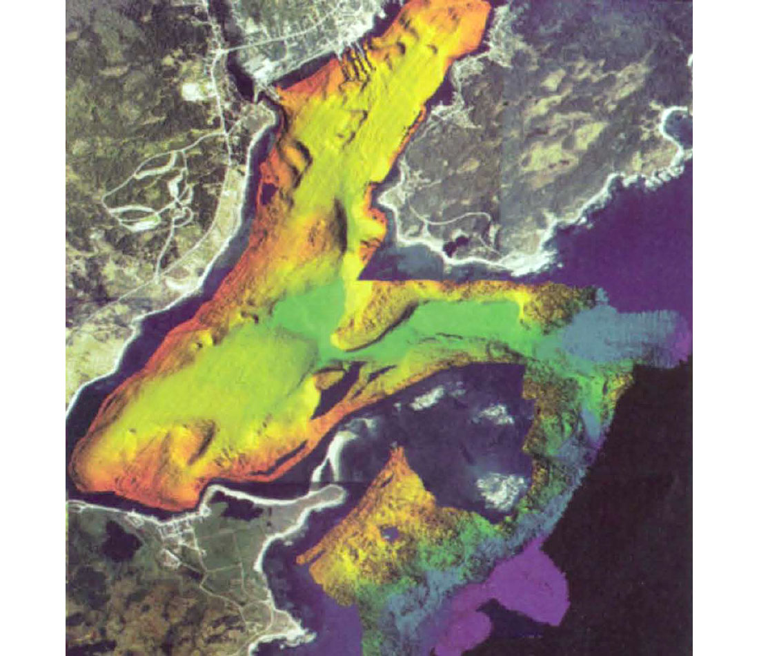
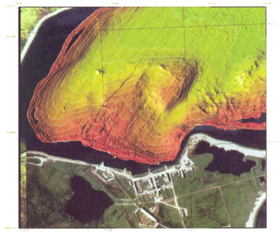
Bathymetry data can be combined with and overlain on other data sets, such as airphotos or maps to show the relationship between on-shore and off-shore features. The image of Louisbourg (figure 2) contains multibeam bathymetric data collected with a Simrad EM3000 system. The bathymetry data were overlain on airphotos of the surrounding area as part of an investigation of changes to the shoreline at the old fortress due to the effects of sea level changes. Figure 3 shows an enlargement of an area near the old fortress. The bathymetry data in this image have been contoured, and the contours overlain on the image.


Join the Conversation
Interested in starting, or contributing to a conversation about an article or issue of the RECORDER? Join our CSEG LinkedIn Group.
Share This Article