Abstract
The San Jacinto Fold Belt is interpreted to be an inverted rift or graben on the northwestern continental margin of South America. Tectonic evolution of the San Jacinto Fold Belt from Cretaceous to present is complex and related to the development of the Caribbean Plate and its interaction with the Cocos, Nazca and South American plates. Tectonism originated in the Upper Cretaceous as a small rift or graben as a result of the opening of the Atlantic. Early sedimentation was characterized by pelagic and hemipelagic sediments, including Upper Cretaceous basalts followed by Palaeocene-Middle Miocene turbiditic deposits derived from the continent. During the Middle Eocene, lateral compressional stresses caused the first phase of inversion. Previous normal faults were reactivated as high angle reverse faults. The subduction zone shifted to the west of the continental margin and the Upper Eocene formations were deposited. At the end of the Eocene a regional tectonic change occurred and sedimentation started in the newly-formed San Jorge and Plato basins to the east. From Oligocene to Miocene the San Jacinto Fold Belt emerged in some places while other locations recorded sedimentation. Upper Miocene-Pliocene rifting in the east generated sedimentation in adjacent basins and in some places in the San Jacinto area. Finally, from Pliocene to Pleistocene, uplift, folding and faulting occurred in the San Jacinto belt and the adjacent western Sinú belt because of Andean tectonic activity.
Geology
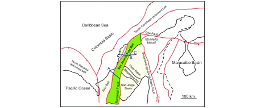
The San Jacinto Fold Belt (SJFB) is located in the Lower Magdalena Valley of northwest Colombia, South America, between the Sinú and San Jorge-Plato basins (Figure 1). The SJFB trends N20E for a length of 360 km and is approximately 20 km wide. On the surface it is expressed by three anticlinoria which are separated by low areas covered by recent sediments. Our work is mainly focussed in the central, San Jacinto anticlinorium area.
Some regional and local studies have been completed in the Lower Magdalena Valley (mainly in the San Jorge and Plato basins), where there is oil and gas production from Tertiary reservoirs (Haffer, 1964; Duque-Caro, 1984; Gulf, 1983; Duque- Caro et al. 1987; Reyes and Camargo, 1995). However, a structural model and an understanding of the tectonic evolution of the San Jacinto Fold Belt do not exist. In addition, the relationship between the San Jacinto Fold Belt and its adjacent basins is not clear.
Although some wells have been drilled in the area, knowledge of the basin is not well constrained because most of the wells are very shallow and do not reach the Cretaceous rocks or the basement.
The geological position of the SJFB makes it vital to understand the regional plate kinematics of the Caribbean area (Figure 2). The SJFB is located at the junction of four tectonic plates: the Caribbean, Cocos, Nazca and South American plates (Pennington, 1981; Kellogg et al., 1985; Mann, 1999).
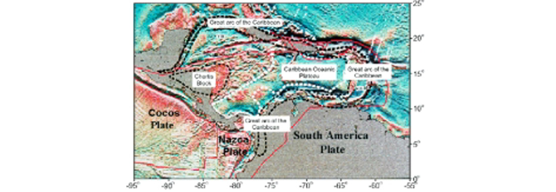
To the north, the Caribbean plate is moving eastward relative to the Americas, accommodated by right-lateral strike-slip faults along the South American plate boundary and left-lateral strikeslip faults along the North American plate boundary. Oceanic lithosphere of the North and South American plates is being consumed along the Caribbean and the Lesser Antillas subduction zone. The Cocos and Nazca plates are subducting beneath the western and southwestern edges of the South American Plate (Mann, 1999).
According to published models, this margin of the South American plate has passed through three main tectonic regimes: a strike-slip margin, an orthogonal A-type subduction zone and an oblique B-type subduction zone (Pennington, 1981; Gulf, 1983; Kellogg et al., 1985). This evolution was accompanied by Neogene strike-slip movement on presently active strike-slip faults. In the first phase, from Upper Cretaceous to Middle Eocene, the Cansona and San Cayetano formations (Figure 3) were accreted. In the second stage, folding and high angle imbricate thrust faults were formed because of A-type subduction during the Middle Eocene. In the third stage, development of a forearc basin took place when B-type subduction occurred between the Caribbean plate and the accreted South American plate (Middle Eocene to present) (Duque-Caro, 1984; Gulf, 1983).
On a regional scale, the sedimentation and tectonic evolution of the SJFB was controlled by four main features, the Romeral fault, the Sinú lineament, the Bucaramanga-Santa Marta fault and the Oca fault (Figure 1).
The Romeral fault forms the eastern border of the SJFB. It continues southward as the boundary of the South American plate. This prominent feature separates western and northwestern Colombia from the main South American Plate and separates oceanic crust to the west from continental crust to the east.
In the study area the Romeral fault limited sedimentation to the west until Lower Oligocene, when sedimentation started in the San Jorge basin. From Upper Cretaceous to Early Eocene, the Romeral fault acted as a megashear with left lateral movement (Gulf, 1983, Escalante, 1990). During Early-Middle Miocene the movement changed to high angle, imbricate reverse faulting, which deformed the Upper Cretaceous rocks.
The Sinú lineament trends N20E, parallel to the Romeral fault, separating the SJFB from the Sinú belt to the west. The expression of this fault is not clear at the surface as it lies below Quaternary alluvial deposits. However, this lineament marks a change in structural style between the San Jacinto and Sinú belts. Also, the Sinu lineament defines the western limit of mud volcanism, which is absent in the San Jacinto Fold Belt.
The Bucaramanga-Santa Marta fault is a left-lateral strike-slip fault active since ?Early Tertiary with a maximum rate of displacement during the Miocene (Gulf, 1983). In the Early Miocene, the Santa Marta massif was uplifted as a horst along the Bucaramanga-Santa Marta and Oca faults. The Bucaramanga- Santa Marta fault forms the boundary between the Plato and Cesar basins and is still active.
The Oca fault is a right-lateral strike-slip fault with approximately 65 km of displacement. It is contemporaneous with the Bucaramanga-Santa Marta fault. The maximum rate of displacement occurred during the Miocene and major displacement along the Oca fault commenced in Late Oligocene (Driscoll and Diebold, 1999).
Major Unconformities
Sediment distribution and non-deposition or erosion are important in the depositional and tectonic history of the San Jacinto Fold Belt and in its adjacent basins. The unconformities reflect tectonic events and, although they cannot be easily identified in the seismic profiles in the SJFB due to poor imaging and structural complexities, they are documented widely in stratigraphic studies through the Lower Magdalena Valley (Duque- Caro, 1984; Gulf, 1983).
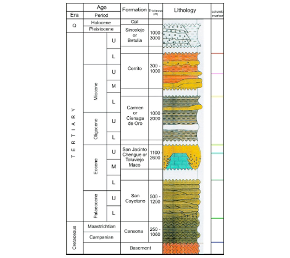
The main unconformities in the study area are Middle Eocene, Middle-Upper Eocene, Lower Oligocene, Middle Miocene, and Upper Pliocene (Figure 3). The Middle Eocene unconformity represents the first compressional event and it is well documented in the northwestern part of South America (Escalante, 1990; Driscoll and Diebold, 1999). The Middle-Upper Eocene unconformity reflects the second phase of deformation in the area.
Reworked microfauna of the Eocene-age San Jacinto Formation in the Oligocene Carmen Formation contain evidence of the Lower Oligocene unconformity. The Middle Miocene unconformity is the second regional unconformity in northwestern South America.
The Upper Pliocene unconformity records a drastic change in the sedimentary environment from marine to continental deposits. This unconformity correlates with the Andean orogeny in the Eastern Cordillera of Colombia. It is recorded at 3.2 Ma and marks the beginning of large amounts of sedimentation of the Sincelejo Formation to the west.
Generally, the SJFB unconformities demonstrate that environments began to change before each erosional interval. Sedimentation resumed afterwards in the form of basal conglomerates derived from nearby continental slopes. Tectonism appears to have been responsible for most of the unconformities. However, other mechanisms, such as relative sea-level fluctuations, changes in the bottom water circulation or water-mass boundaries, could also be responsible in part for interrupting deeper-water deposition. Moreover, all these mechanisms can be linked together with agents such as regional tectonism, readjustment of crustal plate positions and, possibly, climatic cycles.
Seismic Data Interpretation
The interpretation started with the surface geology where geological maps were available and we concentrated on a structural interpretation. Detailed stratigraphic picks could not be followed laterally, therefore only the main unconformities were interpreted. In areas where particularly poor resolution and noise are apparent in the seismic profiles, the interpretation was based on the regional context.
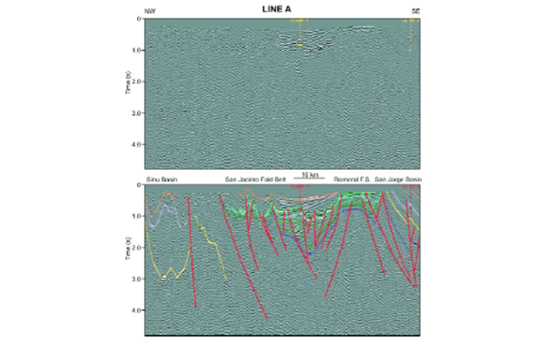
Seismic line A (Figure 4) is a northwest-southeast representative structural seismic section (87.4 km) across the southern San Jacinto Fold Belt. Three wells are close to this line but only one is in the SJFB. From west to east this line shows the Sinú basin, San Jacinto Fold Belt, the Romeral fault system and San Jorge basin. Surface sediments are mainly Quaternary sediments. In the Sinú basin, seismic reflections in the synclines are very clear whereas the associated anticlines are difficult to see (Figure 4). This phenomenon has been attributed to diapirism (Duque-Caro, 1984). In the centre of the line, the SJFB is present, showing the possibly inverted San Jacinto graben covered by Upper Miocene and Pliocene sediments.
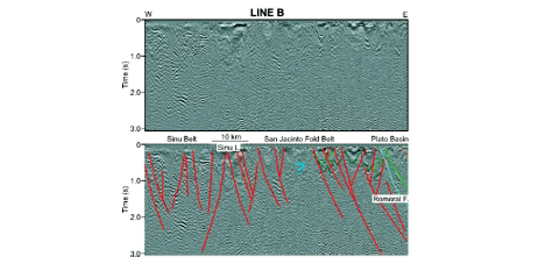
Line B (Figure 5) runs (from west to east) across the middle part of the San Jacinto Fold Belt. The SJFB is located in the middle part of the line, where it is difficult to differentiate any structures or any reflectors. The western part of the line corresponds to the Sinú belt, which has some interpretable reflections. The faulting observed in this line is covered by Quaternary sediments. It is likely that some structures are present in the SJFB but poor resolution makes it impossible to identify any. The east dipping reflections in the eastern part of the line belong to the rocks deposited in the Plato basin, where deposition started in Lower Oligocene.
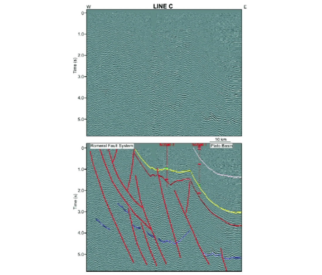
Line C (Figure 6) runs almost parallel to line B and continues further to the east. The seismic data clearly show the basin-bounding fault, dipping eastward, which separates the Plato basin from the San Jacinto Fold Belt. The faults located below the main unconformity, from SP 900 to 1500, could be the expression of the Romeral fault system. It is difficult to identify the basement due to poor resolution at depth. The basement should be continental to the east of this fault system and oceanic to the west. The two wells that project on to this line only reached the lower part of the Lower Oligocene Ciénaga de Oro Formation.
Tectonic Evolution
The new model (Figure 7) for the tectonic evolution of the SJFB is based on the regional interpretation of seismic data, surface geology, integration of the sparse well data and some local studies. Further work is needed to support, or negate, this model.
The San Jacinto Fold Belt was a continental margin of the Colombian Caribbean in the Upper Cretaceous which was likely deformed and accreted to the South American continent as a result of the tectonic interaction of the Caribbean, Cocos, Nazca, North American and South American plates. Evolution of the SJFB commenced in the Upper Cretaceous when pelagic and hemipelagic sedimentation took place on the deep ocean floor. The regional tectonics involved a volcanic arc setting in the sense of Macdonald (1993). Sedimentation was restricted to a small rift or graben, limited to the east by the Romeral fault system or palaeosuture, and to the west by the Sinú lineament. To the east of the Romeral fault, the Cansona and San Cayetano formations were not deposited. Continental crust is present in the east whereas to the west oceanic crust exists (Duque-Caro, 1984; Escalante, 1990).
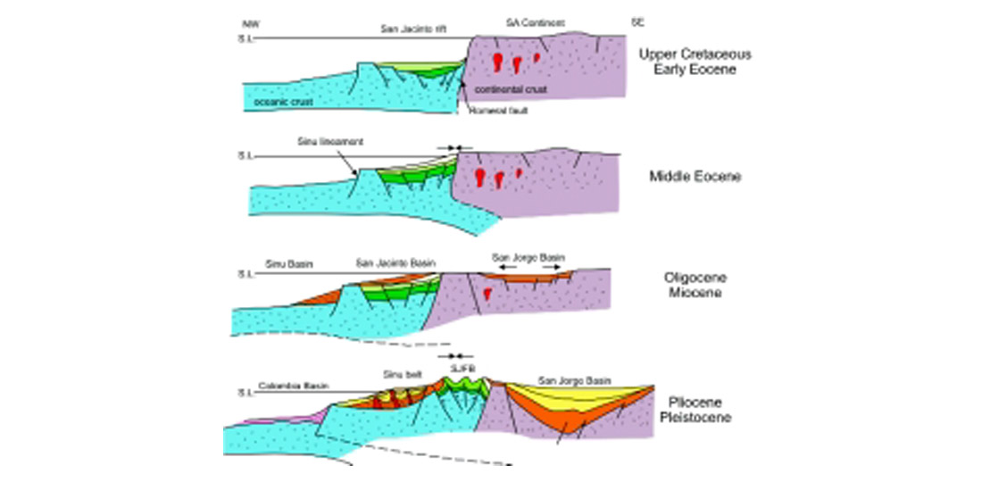
It is difficult to determine how the Romeral fault acted through time because of superposition of structural events and later sedimentation in the San Jorge-Plato basins. According to Gulf (1983), the Romeral fault or Cansona megasuture was a megashear from Late Cretaceous to Early Eocene with left lateral movement. Another interpretation is that the Romeral fault is an easterly dipping Lower Cretaceous thrust fault.
The origin of the proposed rift or graben is the opening of the Atlantic Ocean in the Upper Cretaceous. At this time the Nazca plate began to subduct under the western margin of the South American plate, generating a volcanic arc with the Romeral fault as a suture zone (Kellogg et al., 1985; Pindell et al., 1988; Escalante, 1990; Toto and Kellogg, 1992; Reyes and Camargo, 1995).
The San Cayetano turbidites or flysh syn-rift deposits were deposited from Paleocene to Lower Eocene, followed by deposition of the Maco Formation conglomerates. During this time the continent emerged, including the Santa Marta Massif and the Central Cordillera (Duque-Caro, 1984).
During the Middle Eocene, lateral compressional stresses caused inversion of the rift. Previous normal faults of the rift were reactivated as high angle reverse faults. Possibly, this uplift permitted deposition of the Chengue Formation. At this time the Sinú lineament clearly started to separate the abyssal shelf from the uplifted San Jacinto rift, or graben, and the subduction zone migrated to the west of the continental margin.
During the Upper Eocene the San Jacinto Formation was deposited unconformably over the Chengue Formation, probably due to small pulses of uplift in the SJFB. At the end of the Eocene a regional tectonic change occurred. The Serranía de Perijá, the Santander and the Santa Marta massifs record evidence for pulses of uplifting (Kellogg, 1985). In the Oligocene distension started east of the San Jacinto rift in the continental platform and sedimentation of the San Jorge and Plato basins commenced.
During the Oligocene to Miocene, either uplift of the San Jacinto rift continued or the San Jacinto rift remained emergent. The Middle Miocene unconformity also supports the San Jacinto rift remaining emergent during this time interval. In this area the Ciénaga de Oro Formation (Lower Oligocene – Lower Miocene) and the Porquero Formation (Lower Miocene) were not deposited. However, on the flanks of the San Jacinto rift or graben the upper part of the Ciénaga de Oro and Carmen formations were deposited. These two formations are the first post-rift deposits in the area. The Lower Oligocene unconformity appears to mark the end of the San Jacinto rift.
From Upper Miocene to Pliocene, rifting to the east, produced by lateral compressive stresses due to separation of the Santa Marta massif, generated sedimentation of the Plato and San Jorge basins. The Cerrito Formation was deposited in some parts of the San Jacinto Fold Belt.
From Pliocene to Pleistocene an event of uplift, folding and faulting occurred in the San Jacinto and Sinú belts. This event has been correlated with the Andean Orogeny. During this time an increment of continental sedimentation occurred in the Plato and San Jorge basins. In the Sinú belt diapiric events are associated with this uplift. The abyssal shelf migrated to west of the Sinú basin, where pelagic and turbidite sequences were being deposited.
Discussion
This study interprets the San Jacinto Fold Belt as an inverted paleo-rift or graben developed on the continental margin of the South American plate and initiated in a volcanic arc setting. Other interpretations are possible. The lack of information in both the subsurface and at the surface makes it difficult to either support or negate this model. The few wells in the area are very shallow and do not assist in the visualization of the three dimensions of this basin.
Alternative models include i) continental basin uplifted and folded in the two main compressional events, ii) trench deposits inverted by thrusting and uplift, iii) strike-slip pull-apart basin, and iv) an accretionary wedge model. The last model is the one used by most authors and companies, however there is no clear evidence in the seismic sections for an accretionary wedge.
The fore-arc or volcanic arc setting includes an accretionary complex, trench- slope basins and fore-arc basins (Macdonald, 1993). Sediments typical of these basins include in situ pelagic and hemipelagic sedimentation in a deep ocean floor environment, such as black shales, red clays, cherts, siliceous and calcareous oozes. There should be a clastic supply from the continental side of the complex, a clastic supply from one end of the trench (not represented in the SJFB to date) and sediments carried along the trench by turbidity currents. Stratigraphically, many of the features typical of a fore-arc or volcanic arc setting are present in the SJFB.
The features imaged in the seismic lines A and B lead us to propose that the rift model started with a volcanic arc on a continental margin. There are some very steeply dipping reverse and normal faults resembling a rift. Also, the thrust faults mapped in the San Jacinto Fold Belt have a very steep dip: 70° at the surface. Texas Petroleum (1991) reports two normal faults where thrust faults are mapped. It is possible that these are reactivated thrust faults with more recent normal motion. More detailed field work is needed to unravel problems such as these.
The three main blocks of the San Jacinto Fold Belt have experienced different tectonic events. The San Jacinto anticlinorium is more strongly deformed than the others. It also has the highest mountains in the area (800 m). Many further questions exist. Was the inversion Middle Eocene in age? Was inversion accompanied by transpression? Was motion on the Romeral fault reverse or strike-slip during the inversion? What was the effect of migration of the Caribbean Plate to the east during the Eocene? According to Pindell et al. (1988) the Caribbean plate migrated about 1100 km eastward, beginning in the Eocene. How was this motion accommodated? Another point of discussion involves tectonic versus eustatic processes. How did tectonism affect the sedimentation and vice versa?
Hydrocarbon Potential
In the San Jacinto Fold Belt some wells have been drilled but no oil and gas accumulations of economic importance have been discovered. Ecopetrol drilled a well which produced from an Eocene limestone (5.5 MMCFD) but two other nearby wells were dry. One well produced 100 BODP from the San Cayetano Formation in two years.
The Cansona Formation, with 5.6 TOC, type-II kerogen, is the best source rock in the SJFB. The turbidites of the San Cayetano, Maco and San Jacinto formations are reservoir rocks. The main problem for hydrocarbon potential in the SJFB is the seal and the timing of structures versus migration. Oil was generated in the SJFB, but it migrated before the younger structures were formed.
It is possible that some structures remain with oil, especially where unconformities cover the older stratigraphy. However, these traps could be small. More seismic data, wells and field work are required to discover these possible traps.
Conclusions
Evolution of the San Jacinto Fold Belt was controlled by extensional and compressional events related to the tectonic evolution of the Caribbean area and the subduction of the Cocos and Nazca plates beneath the western and southwestern edges of the South American plate.
The San Jacinto Fold Belt began its development in the Upper Cretaceous with the deposition of pelagic and hemipelagic sediments in a small rift or graben generated by the opening of the Atlantic. It is limited by the Romeral fault to the east and by the Sinú lineament to the west. Lateral stresses during the Middle Eocene inverted the rift. Post-rift sedimentation and a final event of uplift occurred from Pliocene to Pleistocene. During this time the deposition was mainly in adjacent basins.
The main unconformities are Middle Eocene, Middle-Upper Eocene, Lower Oligocene, Middle Miocene and Upper Pliocene. More intraformational unconformities are recorded in the area.
The San Jacinto Fold Belt stratigraphic sequence shares many characteristics with volcanic arc sequences. These include in situ pelagic and hemipelagic sediments clastics supplied from the continent and sediments carried along the trench by turbidity currents.
Previously an accretionary wedge model was used frequently, however the available seismic sections show no clear evidence for an accretionary wedge. More work is needed to integrate all reliable geological and geophysical data, such as stratigraphy, sedimentology, magnetic and gravity surveys, before the best model will be achieved. An improved comprehension of the San Jacinto Fold Belt tectonic processes would improve the development of its hydrocarbon potential.
In the long term, more seismic and well data should be acquired in the SJFB to improve the comprehension of its stratigraphy and structural evolution and to improve exploration results.

Acknowledgements
We gratefully acknowledge the financial and technical support for this project by Ecopetrol-ICP and sponsors of the Fold-Fault Research Project.


Join the Conversation
Interested in starting, or contributing to a conversation about an article or issue of the RECORDER? Join our CSEG LinkedIn Group.
Share This Article