Introduction
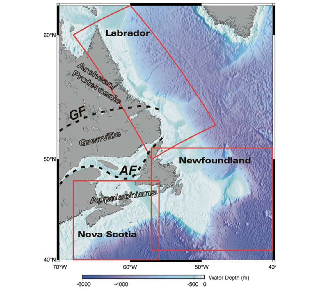
The East Coast of Canada is generally divided into three regions: the Nova Scotian margin in the south, the Newfoundland margin in the centre and east, and the Labrador margin in the north (Figure 1). These margins formed during the past 200 million years as the supercontinent of Pangea rifted apart, first as North America separated from Africa and then as it separated from Europe and Greenland (Figure 2). These episodes of rifting thinned and heated the continental crust and lithosphere, which then subsided to form a complex set of marginal basins. Large amounts of sediment have since accumulated in these basins and formed sources and traps for hydrocarbon deposits. Exploration activity to find and exploit these resources, primarily from seismic profiles and boreholes of the past 30 years, has resulted in the present production of oil off Newfoundland and gas off Nova Scotia. Exploration activities of both commercial and scientific pursuits have also yielded a wealth of basic information that has greatly improved our understanding of the fundamental processes of lithospheric extension and continental rifting that have formed these margins and their hydrocarbon resources.
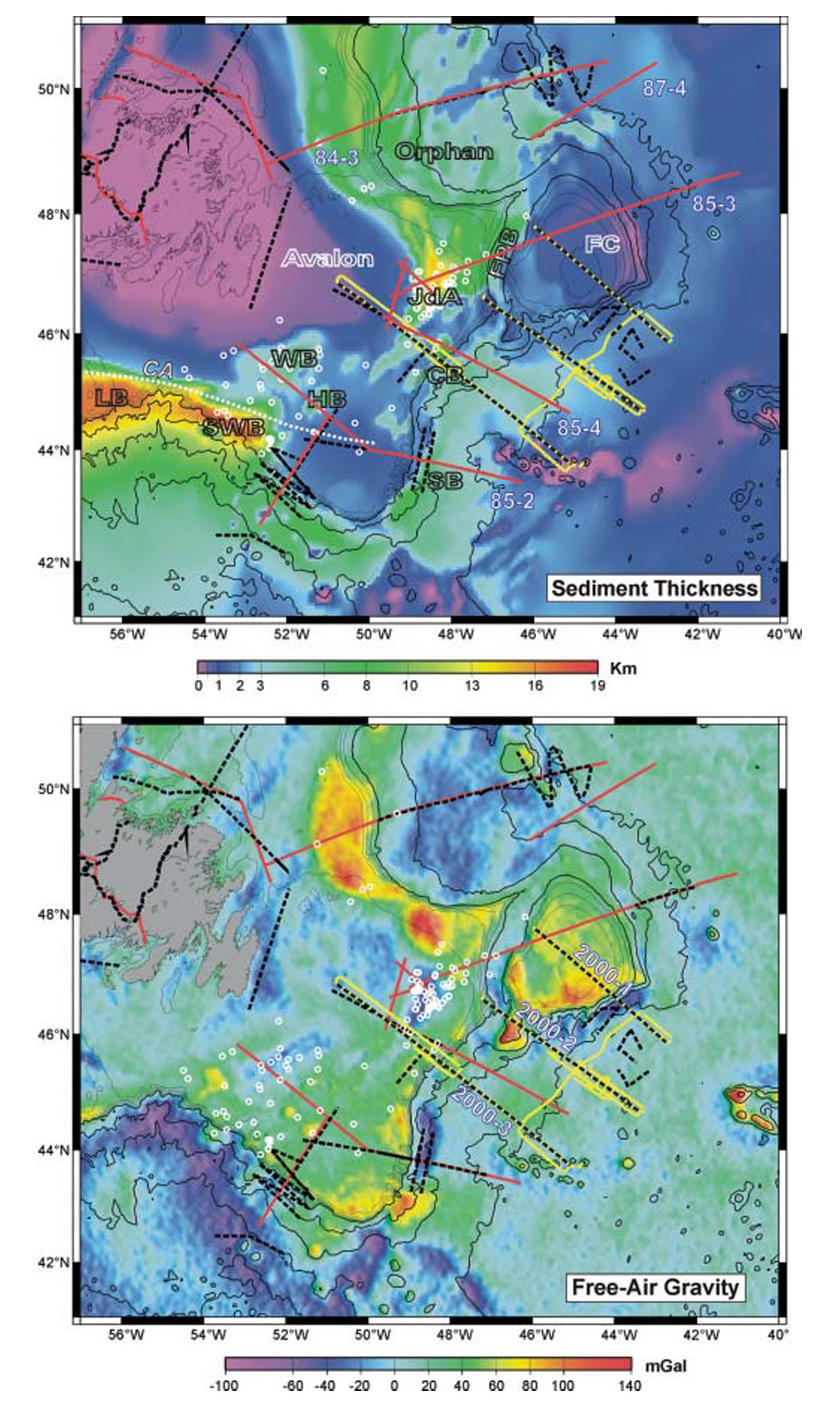
It is the purpose of this brief paper to summarize some of these findings. I will use recently available maps of total sediment thicknesses (Oakey and Stark, 1995) and marine gravity anomalies from satellite altimetry (Sandwell and Smith, 1997) to define the various basins, and some examples of regional seismic profiles to illustrate structures of both sediment and crust. As clearly indicated by the maps and profiles, the complex set of sedimentary basins and their underlying basement structures that form these continental margins extend over a very wide transitional region. A large part of the thick sediment deposits exist in the deeper water slope and rise basins within this transition zone. New offshore exploration activity is now focussing on these deep water basins. If significant accumulations of gas and oil are found, it could fundamentally shift the future emphasis of the Canadian oil and gas industry from west to east. My hope is that results from these new endeavors, both commercial and scientific, may also continue to play an important role in improving our basic understanding of how these transitional regions form.
Plate Reconstructions
Plate tectonic reconstructions of the North Atlantic region are constrained primarily by identifications of marine magnetic anomalies and major fracture zones that formed during the creation of ocean crust (Figure 2; Coffin et al., 1992). Such reconstructions can be used to determine the ages and pre-drift positions of margin conjugates (i.e. continental sections that were once adjacent to each other before subsequent creation of intervening ocean crust). This is important for determining the complete pattern of rifting by juxtaposition of crustal sections across both margin pairs. Of course, as the age and complexity of subsequent plate motions increases so will the uncertainty of the reconstructed positions.
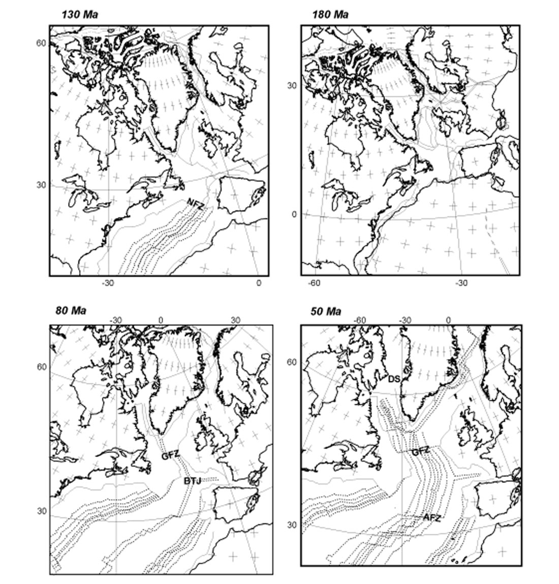
As defined by the reconstructions, the separation of North American and Eurasia formed the North Atlantic margins in five stages, beginning in the south and progressing to the north:
- North America separated from Africa to form the Scotian margin sometime before chron M29 (160 Ma).
- North America separated from Iberia to form the Southern Newfoundland margin sometime before chron M3 (125 Ma).
- North America separated from Europe to form the Northern Newfoundland margin sometime after chron M0 (120 Ma).
- North America separated from Greenland to form the Labrador margin sometime before chron 31 (70 Ma).
- A final stage of rifting separated Greenland from Europe beginning shortly before chron 24 (55 Ma).
The timing and duration of continental rifting is not very specifically constrained by the reconstructions themselves, since the identification of sea-floor spreading anomalies only dates the postrift formation of ocean crust. Often the first clear marine magnetic anomalies are located rather far seaward from the margin, due either to the presence of rather weak anomalies of uncertain origin closer to the margin (southern Newfoundland and Labrador margins) or to the lack of magnetic reversals (Scotian and northern Newfoundland margins) during the Jurassic and Cretaceous Normal Polarities (~210-160 Ma and 118-83 Ma, respectively). More specific dates for rifting would come from exposures on land and/or drilling of syn-rift sedimentary sequences. Other estimates can be made by extrapolating the rates of sea-floor spreading to the margin or by dating of sedimentary sequences or rocks on land.
Such dates suggest that rifting of the older margins may have occurred over an extended period before the formation of ocean crust and may have affected adjacent margin segments. Initial rifting started as early as the Late Triassic to Early Jurassic, as evidenced by a wide-spread volcanic pulse known as the CAMP event at 200 Ma (Marzoli, 1999) and the presence of rift successions encountered in marginal basins (e.g. Hiscott et al., 1990; Olsen, 1997). Rifting continued in the Late Jurassic to Early Cretaceous, as evidenced by basaltic volcanism in basement drill cores of the Newfoundland and Labrador margins (e.g. Pre-Piper et al., 1994; Balkwill et al., 1990).
The extended duration of rifting during most of the Cretaceous (~130 to 60 Ma) progressed further north into the Arctic over a broad and diffuse region but did not succeed in forming much ocean crust north of Davis Strait. This period ended with the arrival of a major pulse of volcanism at 60 Ma associated with the Icelandic plume (White et al., 1987). Shortly thereafter, the final stage of rifting that separated Greenland and Europe at 57 Ma (Larsen and Saunders, 1998) was of relatively short duration. Thus it seems that the initial and final rifting stages of the North Atlantic margins were linked to two major pulses of volcanism at 200 and 60 Ma, while during the intervening period less volcanism was associated with rifting.
Scotian Margin
Rifting on the Scotian margin occurred in the Late Triassic to Early Jurassic (~230-190 Ma), when red beds, evaporites and dolomites formed in fault-controlled half-grabens (e.g. Jansa and Wade, 1975; Welsink et al., 1989; Wade and McLean, 1990). Basement subsidence continued in three main post-rift periods during the Jurassic, Cretaceous and Tertiary, which may be related to subsequent rifting events on the Grand Banks and major reorientation of the plates as described in the previous section. The result of this subsidence was to create a number of major sedimentary sub-basins as shown in the total sediment thickness map of Figure 3a. The Cobequid and Chedabucto faults (Co-F and Ch-F) are the contact between the Meguma Terrane (to the south) and Avalon Terrane (to the north), which formed during the Paleozoic Appalachian orogen. This fault defines the boundary between the late Paleozoic Sydney and Magdalen basins to the north and the Mesozoic Fundy and Orpheus basins to the south. The major sedimentary depocenters, however, are located further offshore in the Sable, Abenaki and Laurentian sub-basins in the east and the Shelburne and other sub-basins to the west.
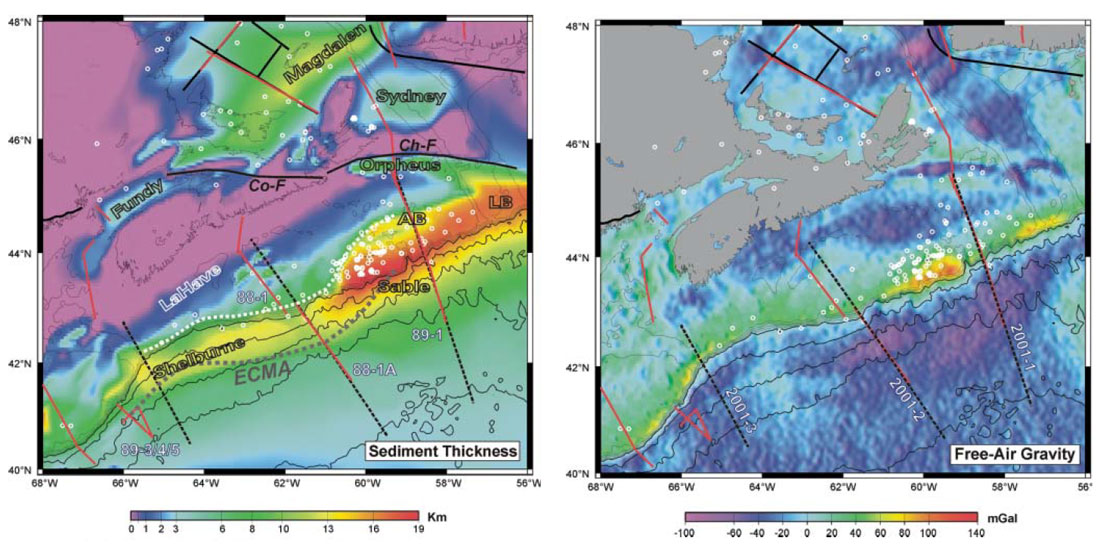
Most studies have previously been undertaken in the Sable basin leading to the discovery of significant gas reserves. The following description is summarized from Welsink et al. (1989) and Wade and McLean (1990). The sandstone reservoirs are located within shallow marine to deltaic sediments and are probably sourced from the Late Jurassic to Early Cretaceous prodelta to pelagic shales of the Verrill Canyon formation. The majority of gas is trapped in rollover anticlines associated with listric faulting. Maturation of the source rock was accomplished by increased post-rift subsidence during the Late Jurassic to Early Cretaceous. Supracrustal faults becoming younger seaward act as migration pathways between the source and reservoir as well as forming the structural traps. Other, more minor occurrences of both gas and oil are associated with Early Cretaceous clastic sequences (Missisauga and Logan Canyon) and are related to the edge of the Late Jurassic carbonate bank (Figure 3a) or salt diapirs. Thus, hydrocarbons in the Sable basin are inherently associated with particular drainage patterns and the existence of post-rift subsidence and faulting.
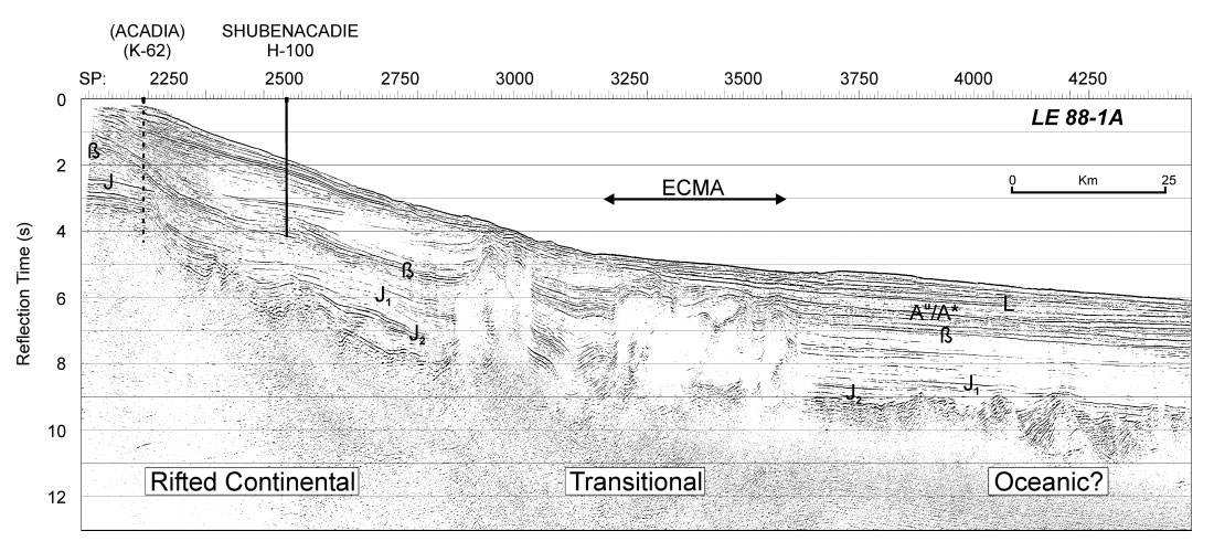
Further offshore, large thicknesses of sediment also occur beneath the lower continental slope and rise of the Sable and Shelburne basins (Figs. 3a and 4). Recent exploration efforts have focussed on these deepwater basins using 2-D and 3-D seismic profiles in preparation for future drilling. It is expected that reservoirs for these deepwater prospects will be associated with Cretaceous and Early Tertiary channels, turbidites and fan deposits, trapped by the steep walls of salt diapirs (Hogg, 2000), such as the ones shown in Figure 4. This Salt Diapiric Province extends along the margin southwest of seismic profile 89-1 (Figure 3a). The location of the salt previously has been used to mark the offshore boundary between the rifted continental crust and post-rift formation of oceanic crust. In seismic profiles (Figure 4), continental basement is imaged out to the start of the salt diapirs, but beneath the salt the basement is not clear. Beyond the salt, basement is at first flat and then rifted by listric faulting (Salisbury and Keen, 1993); but neither of these structures is typical of oceanic basement.
West of the Sable basin, the edge of the Jurassic carbonate bank follows the present shelf edge. In this region (Shelburne basin), the greatest sediment thicknesses occur on the present continental slope and rise as opposed to the outer shelf as for the Scotian and Laurentian basins to the east. Gravity anomalies are also quite different between the western and eastern regions (Figure 3b). Lithospheric thermo-mechanical modelling (e.g. Keen and Beaumont, 1990) has suggested that these differences can be explained as a response to differing patterns of crustal and lithospheric thinning. For the Sable basin model, the region of increasing crustal thinning from continent to ocean was 200-300 km wide and coincident with the region of increasing lithospheric thinning. This led to a wide region of both initial (syn-rift) and thermal (postrift) subsidence that was further deepened by sediment loading. For the LaHave platform model, the crustal thinning was more abrupt (100 km wide) and lithopsheric thinning started further landward. This created a landward zone of thermal uplift and a rather abrupt (<50 km wide) seaward transition zone of increasing initial subsidence. This led to erosion of the platform uplift and syn-rift sediment fill further seaward followed by a wider region of post-rift subsidence. Results from these subsidence models were broadly consistent with data from wells and earlier seismic profiles. However, there was little or no control of the deeper crustal geometry from existing reflection or refraction profiles. In addition, more recent 2-D coverage of the gravity field from satellite altimetry (Sandwell and Smith, 1997) suggests that the Sable sub-basin is rather unique in its gravity signature.
It is possible that the different patterns of sediment deposition and extension along the margin may be related to variations in volcanism during rifting. The North Mountain basalts were emplaced at 200 Ma south of the Cobequid Fault along the southern margin of the Fundy basin during its rifting phase (Olsen, 1997). They form the northern-most exposures of the CAMP basalts which were erupted at the same time and over an extensive region of the proto-North Atlantic margin (Marzoli, 1999).
Evidence for another enhanced period of volcanism during final stages of breakup comes from the presence of the East Coast Magnetic Anomaly (ECMA), which begins to the south of Sable Island (Figure 3). Along the southern part of the Shelburne basin, seismic profiles 89-3/4/5 show that the ECMA is coincident with a zone of seaward-dipping reflectors in the basement (Keen and Potter, 1995). These reflectors are similar to ones found along the volcanic margins of East Greenland, and Northwest Europe where scientific drilling has sampled sub-aerial or shallow marine basalt flows (e.g. Eldholm et al., 2000). Unfortunately the basement beneath the ECMA along the most of the southern Scotian margin is masked by salt (Figure 4) and lies seaward of all but a few of the seismic profiles.
In order to improve our understanding of variations in crustal architecture during rifting of the Scotian margin, a series of three long refraction/wide-angle reflection profiles were shot in summer 2001 (Figure 3b) as part of the Canadian MARIPROBE program (Louden and Hall, 2000). It is hoped that these new data will help resolve the nature of basement transitions and crustal thickness variations along the three profiles. In addition, further control on sediment and basement velocities will allow better depth migration of the existing MCS reflection profiles and constraints on density in gravity models. This may prove particularly useful in regions where salt structures complicate traditional MCS imaging techniques.
Newfoundland Margin
The Grand Banks of Newfoundland (Figure 5) contains a complex series of basins including the Whale (WB), Horseshoe (HB), Jeanne d’Arc (JdA), and Carson-Bonnition (CB). The South Whale (SWB) and Laurentian (LB) basins on its south-eastern margin connect into the Scotian margin to the south. The Salar (SB), Flemish Pass (FPB), and Orphan basins extend beneath the slope and rise to the east and north. The tectonic history is marked by four periods of subsidence and two main periods of regional uplift (e.g. Enachescu, 1987; Tankard and Welsink, 1989; Grant and McAlpine, 1990; Sinclair, 1995). Initial rifting with extension in the NW-SE direction began in the Late Triassic to Early Jurassic with deposition of red beds and evaporites in similar sequences to those on the Scotian margin. A period of reduced subsidence in the Early-Middle Jurassic was followed by a second phase of rifting in the Late Jurassic to Early Cretaceous. The direction of extension rotated to NE-SW causing oblique slip and local transpression on the earlier faults. These sequences are truncated by a major set of mid-Cretaceous unconformities (Barremian to Albian) related to basin inversion and regional uplift. This was followed in the Late Cretaceous by further post-rift subsidence on the Banks and extension in Orphan Basin. A base Tertiary unconformity, particularly prominent in the northern region, post-dates rifting.
The mid-Cretaceous unconformities are related to breakup of the Grand Banks first from Iberia and then from the Rockall margin, when the mid-ocean rift between North America and Africa finally propagated to the north. A major volcanic pulse off the Tail of the Banks formed the “J-anomaly” basement ridge and magnetic anomaly (Tucholke and Ludwig, 1982), which also is observed off the southern Iberian margin. This may be related to mid-Cretaceous volcanism that has been sampled in several wells (Pre-Piper et al., 1994), but which was previously attributed to rifting and transform motion. Thus there are two primary candidates for causing the Cretaceous uplift and inversion: (i) a response to in-plane compressional forces created by varying rates of extension and rotation of the axis of extension from NW to NE (Karner et al., 1993); or (ii) a response to added buoyancy created by volcanic underplating of the margin, in a similar manner as proposed to explain uplift and cyclic deposition of submarine fans in the North Sea (White and Lovell, 1997). The nature of the base Tertiary unconformity, however, is still unclear.
The complex rifting and subsidence history mentioned above has led to a combination of stratigraphy, structure and timing conducive to hydrocarbon generation and entrapment (Bell and Campbell, 1990). So far, however, significant discoveries have only been located within several fields (e.g. Hibernia, Terra Nova, Whiterose) of the northern Jeanne d’Arc basin. Primary reservoirs are located in Late Jurassic and Early Cretaceous shallow marine and fluvial sandstones deposited during the second rift and postrift phases. Late Jurassic shales of the Egret member contain a marine-rich source that matured during subsequent burial within the Late Cretaceous and Tertiary. Traps were formed by the mid- Cretaceous from rollover anticlines (e.g. Hibernia structure) and rotated fault blocks, and they were largely preserved during the subsequent Avalon uplift and erosion.
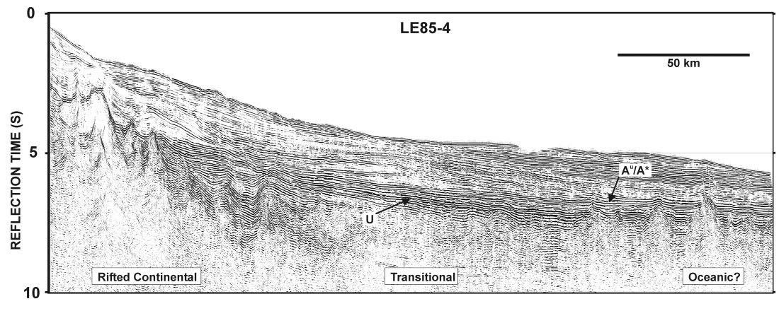
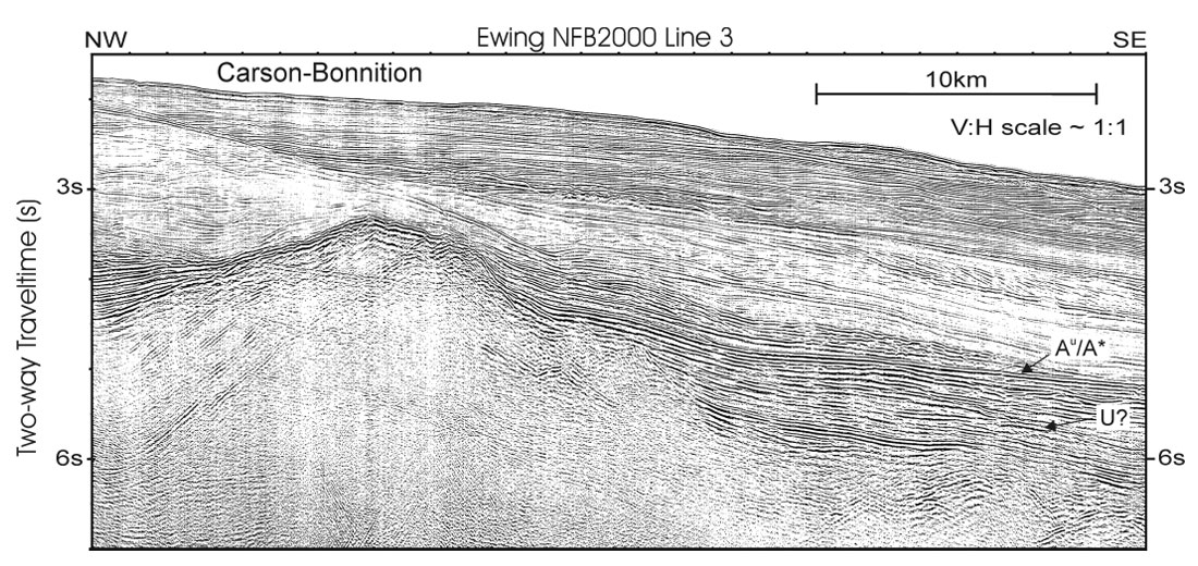
Most exploration has concentrated on the Jeanne d’Arc basin and other shallow water basins on the Banks. Only a few wells have been drilled in deeper water. However, the sediment distribution map (Figure 5a) shows that significant thicknesses exist beneath most areas of the rise and slope bordering the Banks (e.g. South Whale, Salar, Carson-Bonnition, Flemish Pass and Orphan basins). Recently, additional seismic exploration has been undertaken in these deeper water basins to further assess its economic potential. Previous analysis of the deeper offshore regions were made using a few regional seismic profiles collected in the mid- 1980’s (e.g. Keen and de Voogd, 1988; Tucholke et al., 1989). A more recent set of regional profiles (Figure 5) now extends this coverage across the northern Newfoundland basin. The deeper water part of the LE85-4 profile is shown in Figure 6 (J. Hall and S. Deemer, personal communication, 2001) and a short section of the recent Ewing2000-3 profile (Louden and Lau, 2002) across the Carson basin in Figure 7. A series of tilted basement fault blocks is observed up to 100 km seaward from the shelf break. The first is a large block possibly with some salt cover that divides the offshore side of the Carson-Bonnition basin into shallower and deeper water sections. The deep-water region of thicker sediment and complex basement structure may hold the best potential for hydrocarbons (Enachescu, 1992).
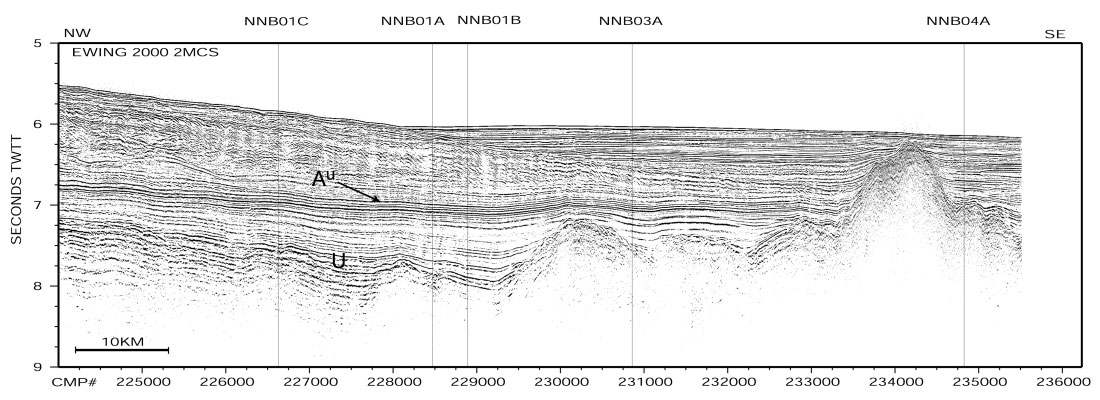
Further seaward of the faulted basement, a 100-km wide region exists where a prominent reflector (U) masks the underlying basement. This reflector appears to terminate against a series of elevated basement highs. Above the U-reflector, the Au_ A* reflector defines the Tertiary transition between flat-lying and bottom current dominated depositional sequences. It is not certain if the U-reflector is related to the Avalon unconformity of the southern Banks and/or the Early Cretaceous ß-reflector observed off the Scotian margin (Figure 4). The nature of the relatively flat-lying basement within this transitional region is also uncertain. Recent drilling and seismic results indicate the presence of a wide zone of serpentinized peridotite basement in a conjugate setting beneath the Iberia margin (Louden and Lau, 2002). A similar model was previously proposed by Enachescu (1992) for the Newfoundland basin. Possible drilling targets to resolve these issues have been selected along profile Ewing 2000-2 in the northern part of the basin (Figure 8). A drilling leg of the Ocean Drilling Program is scheduled for this work in July-Sept 2003.
To the northwest of Flemish Cap, a very wide zone of thick sediment exists within Orphan basin. This region experienced rifting episodes that may have extended into the Late Cretaceous. Most of the basin is underlain by highly thinned continental crust but its deep water has precluded much drilling activity. The gravity highs associated with the shelf edge (Figure 5b) shows a significant difference from gravity lows associated with most of the other basins. This has been modeled by replacing the lower crust with mantle, suggesting the presence of a failed rift that was abandoned when continental breakup shifted further to the northeast (Chian et al., 2001). A very thick sequence of Tertiary sediment in the deeper water regions of Orphan basin indicates a predominance of post-rift rather than syn-rift subsidence (Keen and Dehler, 1993).
Labrador Margin
The Labrador Sea is a northwestward extension of the North Atlantic Ocean, from the Charlie-Gibbs fracture zone in the south to Davis Strait in the north (Figure 2), which separates southern Greenland from Labrador. Rifting and breakup of these margins began during the Early Cretaceous (~125 Ma) and ended during the Late Cretaceous (~85 Ma) based on borehole data (Balkwill 1990). Volcanics of Cretaceous and early Tertiary age onlap the rift structures and synrift sediments. In the region of Davis Strait, a final period of intense volcanism in the Paleocene (~60 Ma) is associated with the North Atlantic Magmatic Province (Gill et al., 1999). Unlike the Newfoundland and Nova Scotia margins to the south, the pre-existing continental crust varies substantially in its ages and crustal properties: from the Paleozoic Appalachian Province in the south, through the Late Proterozoic Grenville Province to the Early Proterozoic Makkovik Province, and finally the Archean Nain Province (Figure 9). A recent review of geophysical properties of these crustal units, based on results from the Lithoprobe ECSOOT program, is given by Hall et al. (2002).
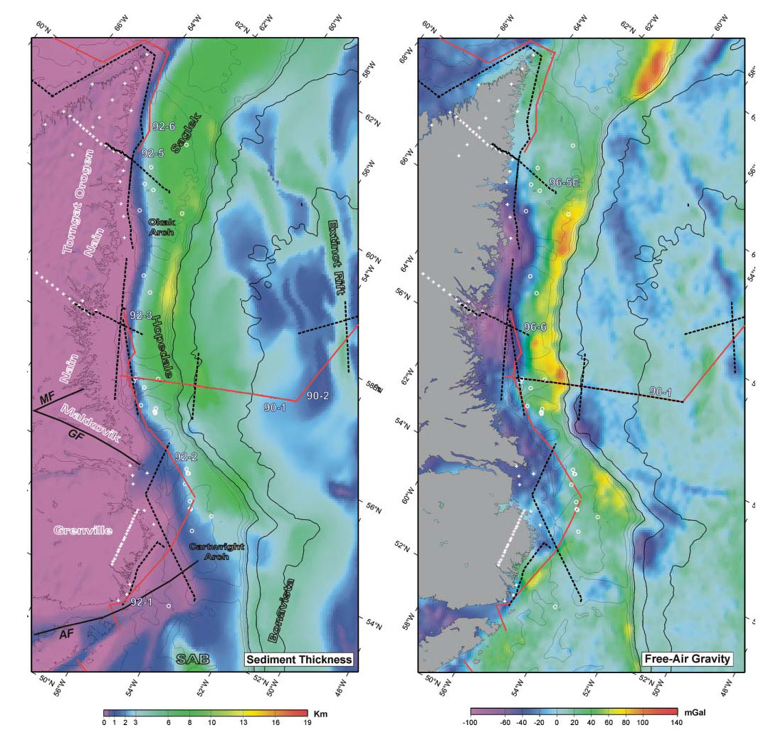
Following rifting, subsequent seafloor spreading in the Labrador Sea is documented by magnetic lineations (Roest and Srivastava, 1989), beginning first in the south during the Late Cretaceous (~70-80 Ma), and then propagating to the north and ending in the Late Eocene (~40 Ma) when seafloor spreading ceased. A major change in spreading occurred at ~55 Ma when rifting began separating Greenland from Europe. During its syn-rift and post-rift period, an immense set of oval-shaped sedimentary basins separated by crustal arches formed along the deeply subsided crust of the Labrador shelf (Figure 9). Following the initial coarse-grained syn-rift deposits, there was a short period of sediment starvation followed by a large amount of clastic sediment influx during the Late Cretaceous and Tertiary. This led to a major seaward progradation of sediment over the rift-age grabens and ridges. As the basement continued to subside, successive Tertiary sediment horizons downlap and thicken seaward as the shelf attained its present position. In comparison, the Southwest Greenland shelf is narrow and has experienced little or no subsidence south of 63°N (Rolle, 1985). Thermal models of borehole data from the Labrador margin were the first to include a greater amount of lithospheric versus crustal stretching (Royden and Keen, 1980) in order to explain its larger post-rift versus syn-rift subsidence history.
During subsidence of the Labrador margin, terrigenous source rocks within the Upper Cretaceous Bjarni Formation and Upper Cretaceous to Paleocene Markland Formation matured primarily to form gas. Of the 31 wells drilled on the Labrador margin during the 1970’s and early 1980’s, there were six hydrocarbon discoveries of which the largest was the Bjarni gas pool (Bell and Campbell, 1990). Hydrocarbon reservoirs for these discoveries are formed in structural traps of Lower and Upper Cretaceous fluvial sandstone overlying basement horst blocks.
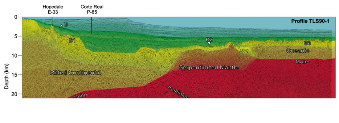
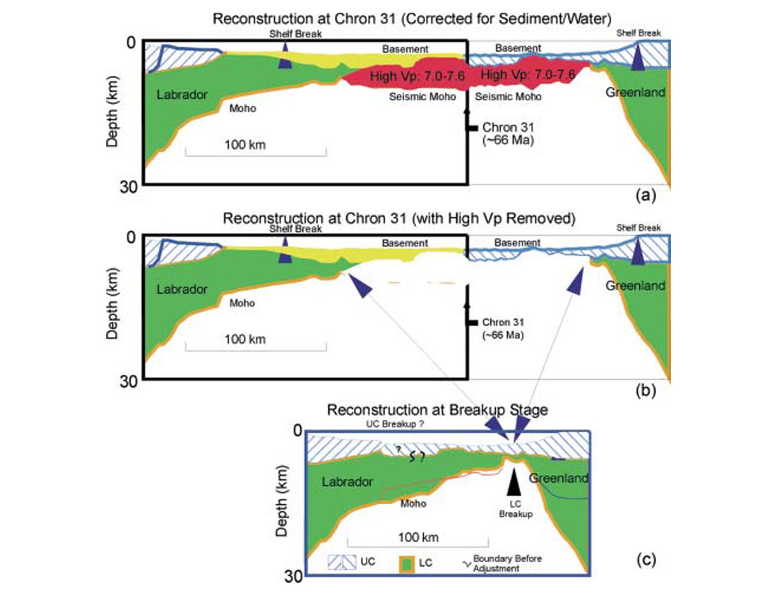
Obviously, there is much less recent seismic coverage of the Labrador margin than for the Newfoundland and Nova Scotian margins. However, because of the limited width of the Labrador Sea and relatively simple seafloor spreading history, a single regional profile was shot that spans the complete width of the basin and its conjugate margins (Keen et al., 1994). In addition, several separate but coordinated refraction profiles were shot along and across the same transect. Combination of these data has allowed a complete depth section to be made from seafloor to mantle across the entire basin (Chian et al., 1995; Louden et al., 1996). The section across the Labrador margin is shown in Figure 10. Of particular note is the interpretation of a wide zone of thinned continental crust beneath the outer shelf and slope, which contrasts with previous interpretations of oceanic crust (e.g. Balkwill et al., 1990). Further seaward, a zone of high velocity lower crust, interpreted as partially serpentinized mantle, separates the zones of thinned continental crust (landward) and oceanic crust (seaward). Basement above the zone of serpentinized mantle is relatively flat, in contrast with the faulted basement to either side. A prominent sub-basement reflector marks the top of the higher velocities of the serpentinized mantle. This sub-horizontal horizon contrasts to the dipping crustal reflectivity to either side. Based on this profile and a similar one across the Southwest Greenland margin, a balanced crustal reconstruction of the two conjugate margins at the point of breakup is shown in Figure 11 (Chian et al., 1995). This indicates that a highly asymmetric pattern and absence of significant amounts of mantle melt must have resulted late during the rifting process, in contrast to predictions from pure-shear models (Louden and Chian, 1999). It would certainly be interesting to know if this asymmetry is a common feature of these margins. A subsequent refraction profile 92-5 (Hall et al., 2002) indicates a more abrupt initial thinning of the continental crust further to the north (Figure 9), but it does not sample the complete transition into the oceanic basin.
Conclusions
Several basic relationships are common to these margins:
- Rifting activity persists for a substantial period of time before breakup and subsequent seafloor spreading. For the Nova Scotian margin this period was as great as 40-50 Ma, for the Newfoundland margin 30-40 Ma and for Labrador 40-65 Ma. Pulses of volcanic activity during rifting may occur, possibly resulting in platform uplift as a result of localized underplating and/or thinning of the lithosphere, but these pulses seem to be localized rather than regional in extent. Thus the margins are predominantly non-volcanic.
- The spatial extent of primary rift activity eventually leading to breakup on the southern margin extends laterally to the adjacent margin to the north. Thus the Late Triassic to Early Jurassic rifting on the Scotian margin also affected the Grand Banks and the Late Jurassic to Early Cretaceous rifting on the Grand Banks also affected the Labrador margin.
- A zone of transitional basement ~150 km wide exists seaward of the stretched continental crust and landward of the first normal oceanic crust. This zone is associated with characteristic changes in basement morphology and depth across the transition zone, with the deepest, flat-lying basement on the landward side and elevated basement highs on the seaward side. One possibility is that this zone is composed primarily of serpentinized mantle with only minor amounts of crustal melt (Louden and Chian, 1999). The existence of this transition zone is most likely a consequence of very slow rates or multiple periods of extension.
- Additional crustal refraction profiles recently undertaken off the Newfoundland and Scotian margins will help to show whether the crustal variations previously observed off Labrador are common to these other margins. Connection of these profiles with similar profiles across their margin conjugates will help demonstrate whether the high degree of breakup asymmetry observed for the Labrador-Greenland transect is a common feature of the other margin segments. This would indicate whether such asymmetry is a fundamental outcome of slow rates of lithospheric extension.
Regardless of how many seismic profiles and models we make, however, eventually we need to drill and core at a few locations to determine what is really there. This is true for basement objectives as well as for sediment sequences. New scientific drilling in the Newfoundland basin by the Ocean Drilling Program if successful will help to resolve some fundamental questions about its formation. But additional drilling through sequences on the slope and rise will also be needed in order to fully understand the nature of other major structures. Perhaps with a continued combination of both scientific and commercial activities, as have previously resulted in such a wealth of both knowledge and resources, these future goals can be accomplished.

Acknowledgements
The Canadian MARIPROBE program is supported by the Natural Sciences and Engineering Research Council of Canada. It is a collaborative project between Dalhousie University, Memorial University of Newfoundland, University of Calgary and the Geological Survey of Canada. As part of this program, new seismic data was collected in the Newfoundland basin during the SCREECH-2000 project of the Woods Hole Oceanographic Institution and the University of Wyoming, with support from the U.S. National Science Foundation, and with the Danish Lithosphere Centre.


Join the Conversation
Interested in starting, or contributing to a conversation about an article or issue of the RECORDER? Join our CSEG LinkedIn Group.
Share This Article