Summary
Exploration risks commonly associated with the seismic definition of Lower Cretaceous incised valley channel sandstone (IVCS) reservoirs are: I) the distinction of shale versus sandstone and 2) ambiguities caused by seismic interference from both the underlying Paleozoic unconformity and younger Mannville coals. A post-drill review of two wells drilled during 1995 east of Calgary. Alberta (Twp 23, Rge 26 W4) has highlighted further complexities with the prediction of a shale versus sand filled incised valley system of the Glauconitic formation within the Lower Cretaceous Mannville group. Through the use of an integrated geophysical and geological look-back a better understanding of the risks of exploring for incised valley systems in mixed sandstone versus shale prone areas has developed. This increased understanding of the risk can also lead to the identification of additional exploration opportunities.
The interpretation of 263 square kilometers of three dimensional (3D) seismic initially defined the prospect. The Glauconitic seismic reflection amplitudes indicated tributary channel sandstones up to 22 meters in thickness within a tributary channel system ISO to 300 meters wide and in excess of eight kilometres long extending off the 3D survey. Two anomalies were tested.
The drilling of the wells encountered eight meters of carbonaceous shaly mudstone initially interpreted as non-channelized regional Glauconitic. However, reevaluation of the 3D seismic, with confirmation of phase using vertical seismic profiles and observation of subtle sonic, density and gamma changes, confined the anomaly. Further study incorporating core data and modern clastic depositional analogues established the anomaly as a relatively thin carbonaceous shale filled channel within an abandoned fluvial - estuarine channel system. The compressional wave seismic signature of thin carbonaceous shale filled channels can resemble thick IVCS reservoirs.
Introduction
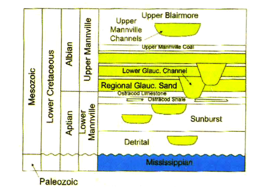
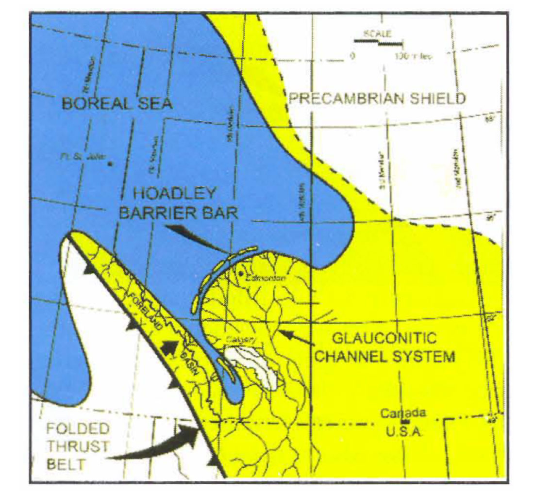
When the drilling of seismic anomalies produces unforeseen results, the answer is not always found through reworking the seismic but through re-evaluating the geology. However, the geological community may not agree with this! The Glauconitic IVCS outlined on the Carseland South 3D data is located in Twp 23, Rge 26 W4, 30 kilometres east of Calgary, Alberta (figure 1). In the Carseland area, the clastics of the Lower Cretaceous Mannville group lie unconformably on the carbonates of the Upper Paleozoic (figure 2). The Ostracod limestone, at the top of the Lower Mannville, divides the Mannville group into a lower and upper unit (after Farshori, 1983; Glaister, 1959). Lower Glauconitic IVCS of the Upper Mannville group truncate regional markers in the Lower Mannville Ostracod formation and regional Glauconitic facies. The Glauconitic IVCS extend from South East Alberta northwest to the Hoadley barrier bar (figure 3). On seismic, the Paleozoic unconformity is usually a peak on normal polarity indicating an increase in acoustic impedance.
Seismic Risks, Data and Prognosis
The discrimination of shale from porous sandstone on compressional wave amplitude data is often difficult due to their similar acoustic impedance. Identification of these two lithologies is possible with the use of shear wave data to create compressional versus shear wave velocity ratios, which was not available in this case. The low impedance of Upper Mannville coals can create tuning effects with the Glauconitic seismic event making interpretations ambiguous in some cases. In addition, in areas of Paleozoic unconformity structural highs, reflections from the Paleozoic top interfere constructively with the Glauconitic reflections causing amplitude anomalies resembling porous sandstones.
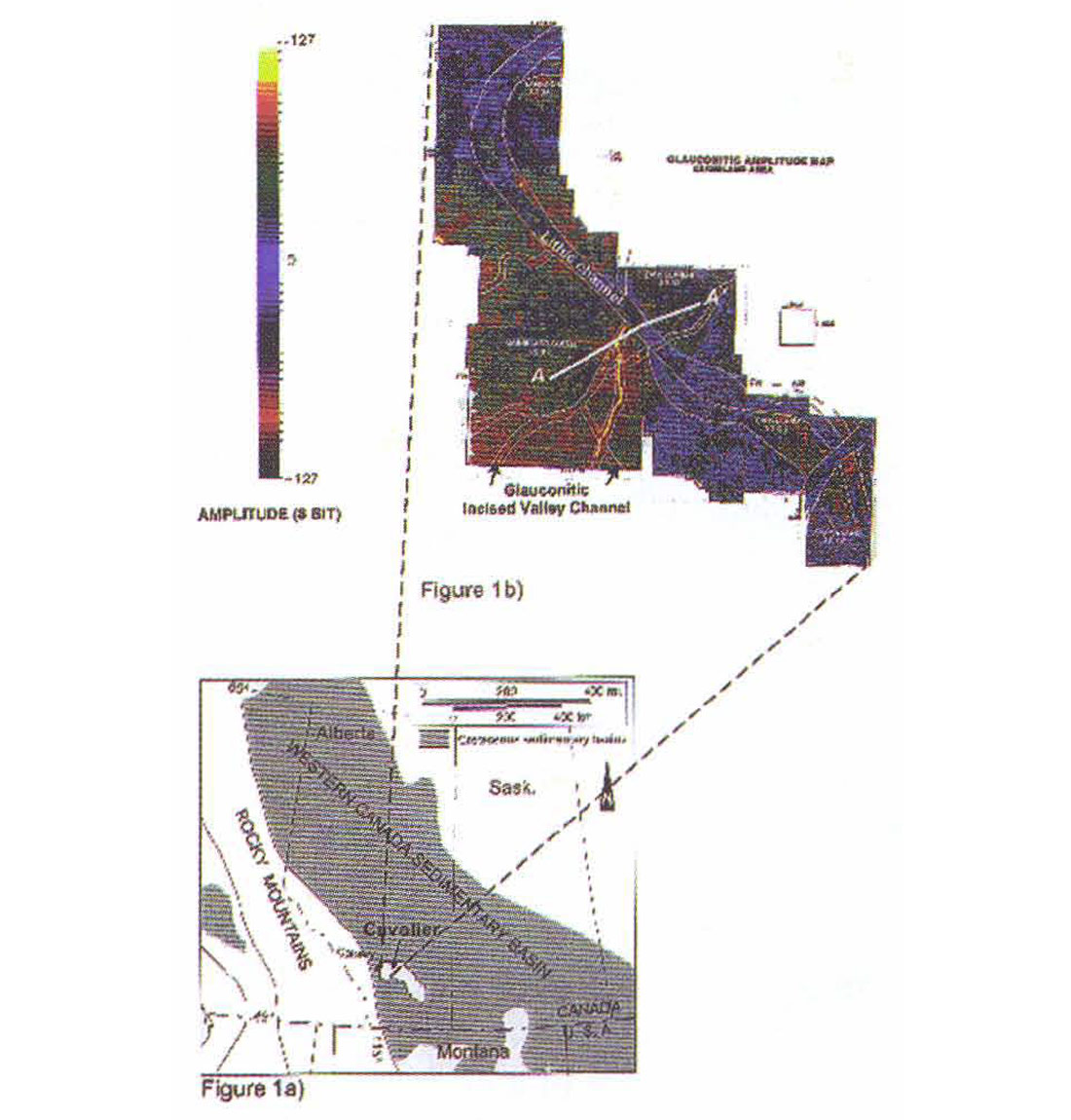
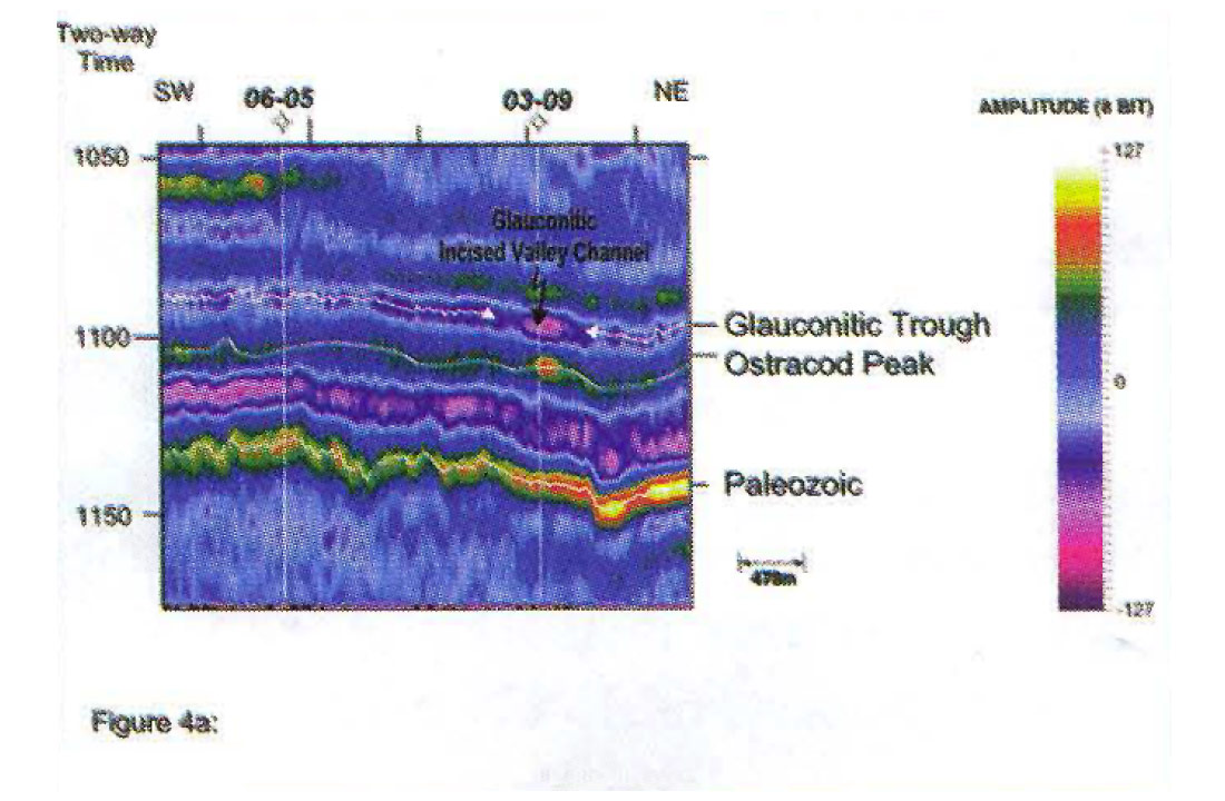
A dataset of five merged 3D seismic surveys tied to local well control outlines the seismic prospect and possible trapping configuration (figure 1). Normalized amplitudes from the five 3D seismic datasets provided a uniform amplitude map across the surveys. Considering the known risks attributed to this play type, the most likely depositional setting and trapping configuration for this prospect is a thick tributary Glauconitic IVCS terminated updip by a younger tight channel. The seismic anomaly is similar in attributes to an existing 22 meter thick channel sand in the nearby Cavalier pool which is located on figure 1a. The seismic response consists of two amplitude anomalies. On seismic, the Glauconitic trough reflection at the top of the expected porous channel sandstone is two times the amplitude of the adjacent trough from the regional Glauconitic event. An amplitude increase occurs on the peak below from the base expected porous sandstone reflection (figure 4a). The initial prognosis indicated a porous sandstone up to 22 meters in thickness within a channel system 150 to 300 meters wide and mapped in excess of eight kilometers long extending off the 3D survey.
Although the interpretation defined a narrow channel, the sandstone thickness of 22 meters would provide enough pay to be an economic prospect. The only ambiguity in this seismic interpretation was determined to be sandstone versus shale distinction; encountering a shale filled channel section and no reservoir was considered a possibility. The seismic in figure 4a displays no interference from the Paleozoic unconformity below the Glauconitic reflection event. Amplitude maps of the Mannville coals identified no tuning above the Glauconitic reflection.
Drilling Results
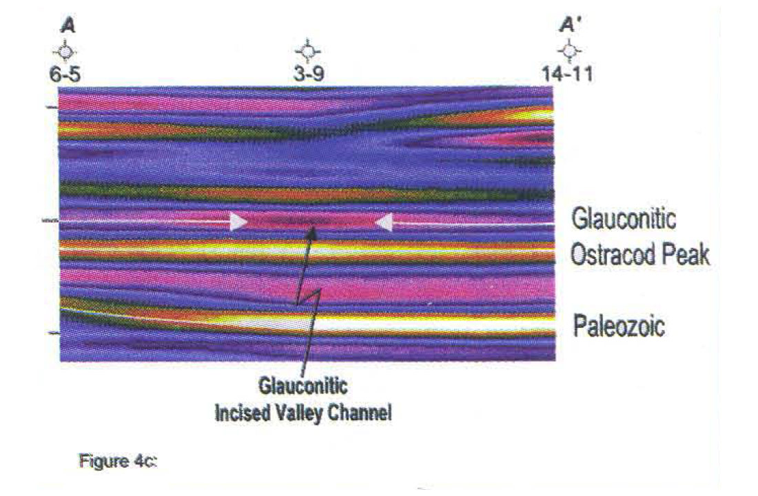
The drilling of the wells intersected across the zone of interest eight meters of carbonaceous shaly mudstone. The presence of regional markers in the underlying Ostracod, normally truncated by channel incisement, suggested a non-channelized regional Glauconitic. However, truncation of regional Glauconitic markers and re-evaluation of the 3D seismic confirmed the anomaly. Comparison of the seismic with a vertical seismic profile established the data to be zero phase and this eliminated the possibility of miscorrelation as a result of incorrect phase. Testing of five migration velocities did not change the amplitude anomalies of the Glauconitic. However, by observing subtle sonic, density and gamma changes on logs and by correlation of new seismic modelling to the 3D data the anomaly was established to be a response to lithologic changes (figure 4b and c).
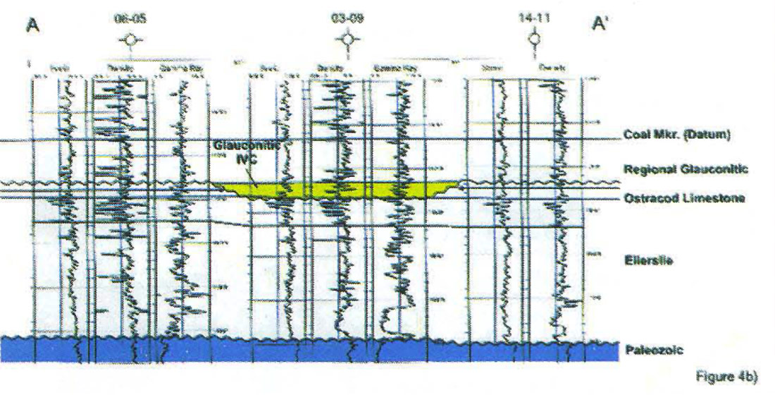
This log correlation illustrates the additional complexity of identifying carbonaceous shaly mudstone on seismic as a distinct facies from shale, coal or porous sandstone. With its low acoustic impedance relative to a porous sandstone, a thin carbonaceous shale filled channel can have a similar seismic signature to a thick channel sandstone. The low acoustic impedance of the carbonaceous shale creates a strong reflection event below tuning thickness of the zone.
Geological Evidence
Two possible models exist to describe the carbonaceous fill of the IYC: 1) a flood tidal delta channel or 2) an avulsed tributary channel system (TCS). Table 1 lists the characteristics of these.
The scale of the seismically mapped channel tends to favor a TCS. Core information gave conclusive evidence for this TCS. Observation in core of a Glossifungites at the channel base clearly defined the TCS. The well developed Glossifungites ichnofacies suite (a brackish restricted trace fossil assemblage) at the IYC base and an abrupt downward shift in facies between the IVC basal sandstone and regional mudstones, indicates a sequence boundary. This taken together with the truncation of regional markers in the Glauconitic and the mappable extent of the sequence boundary indicated that the drilling intersected a shallow IVC that was subsequently abandoned and filled with organic muds The final interpretation defined a relatively thin carbonaceous shale filled channel within an abandoned fluvial - estuarine channel system.
Further exploration opportunities within these TCS are possible. Two abandonment mechanisms lead to different exploration potential: stream capture or backfilling during transgression. In the case of stream capture, laterally adjacent sandstone filled channels provide exploration potential. In the case of backfilling during transgression, sandstones towards the headland provide exploration opportunities.
| Flood Tidal Delta | Tributary Channel System | |
| overall lobate geometry | sinuous channel geometry | |
| landward bifurcation | landward bifurcation | |
| one to two kilometers long | tens of kilometers long | |
| no Glossifungites surface | Glossifungites surface |
Conclusions
For economic reasons, no exploration opportunities presently exist within this channel trend example. Sandstones which may exist towards the headland would be too thin to justify economically. However, adjacent channel trends within this area may lead to further drilling opportunities.
This study has established a greater understanding of the risks involved. Thick, 22 meter, channel sandstones may have an identical seismic signature as a thin, eight meter, carbonaceous shale filled channel. Important sedimentological and trace fossil observations made in core led to the identification of the depositional environment. This combined with the geophysical mapping and correlations was the key to defining the risk in this area. Due to seismic resolution limitations, the seismic response of narrow and shallow cut abandoned channels can resemble deep cut sand filled incised valley channels. This ambiguity motivates further effort to acquire and process higher resolution 3D seismic and shear wave seismic.

Acknowledgements
We would like to thank PanCanadian Petroleum for permission to publish this study, Bill Goodway for his valuable advice and the Cavalier team including Ian Shook and Andre Politylo for their input to our seismic templating of the Cavalier field. The patience and suggestions of the PanCanadian drafting department are sincerely appreciated.


Join the Conversation
Interested in starting, or contributing to a conversation about an article or issue of the RECORDER? Join our CSEG LinkedIn Group.
Share This Article