Abstract
The Orphan Basin region, situated north of the Grand Banks of Newfoundland has undergone repeated extensional episodes. Crustal stretching of the mainly Paleozoic platform started in Late Triassic to Early Jurassic. Subsequent extensional episodes lasting until the Paleocene deepened the basin and enlarged it, by westward (landward) propagation of rifting. Seismic interpretation integrated with potential field data provides a regional understanding of the basin’s structural setting and evolution and indicates the presence of a viable petroleum system. This includes large extensional anticlines which were also modified by compression. The presence of Jurassic source rock in the East Orphan Basin is convincingly supported by seismic correlation to source rock intervals within the adjacent Jeanne d’Arc and Flemish Pass basins, and by paleo-oceanic correlation with the Porcupine Basin off the western coast of Ireland.
Introduction
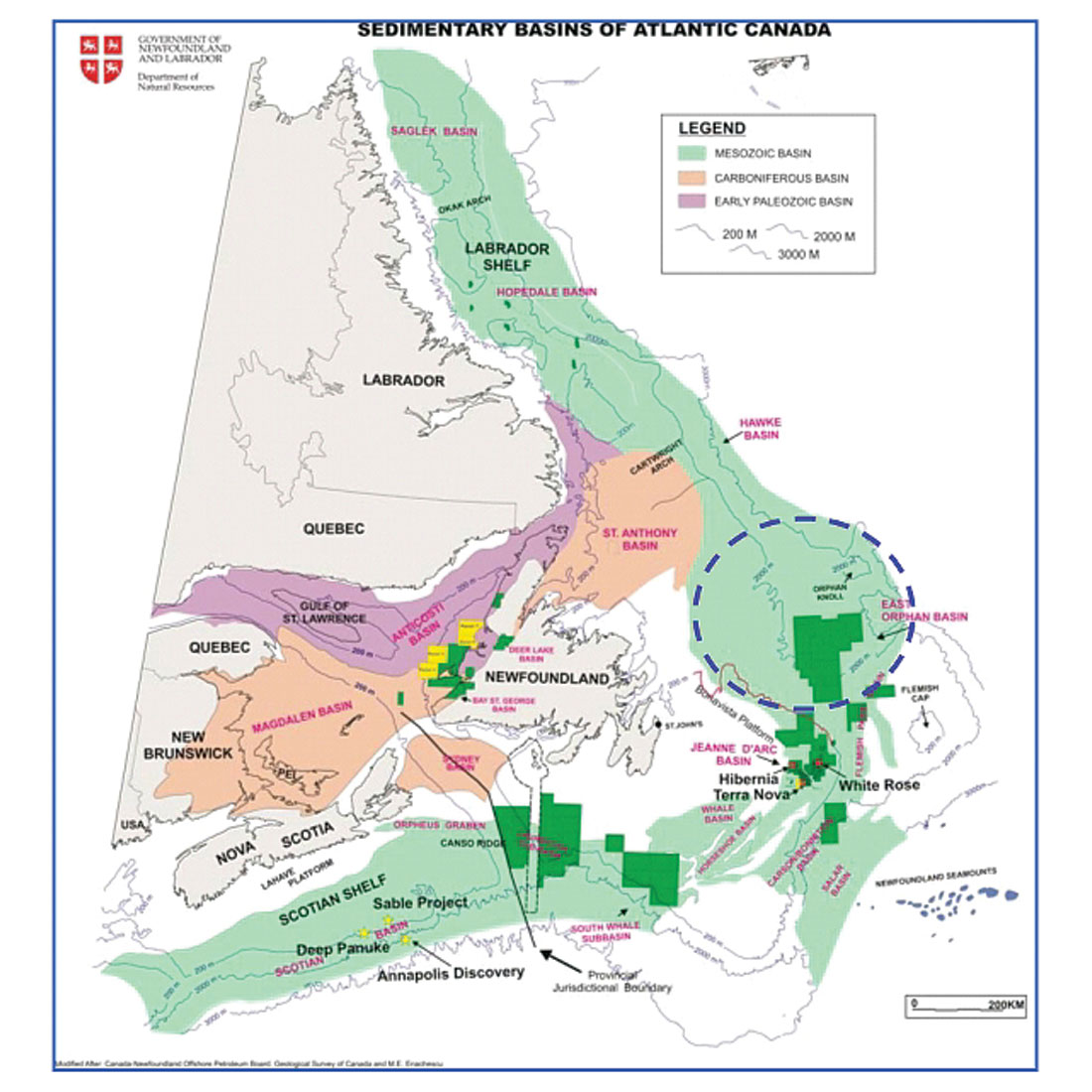
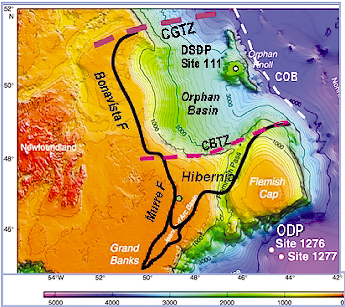
Newfoundland and Labrador’s divergent margin contains numerous Paleozoic and Mesozoic basins and sub-basins (Figure 1). The Orphan Basin is a wide continental rift located northeast and adjacent to the Jeanne D’Arc Basin from which approximately 400,000 barrels per day is currently being produced from three fields, Hibernia, Terra Nov and White Rose. With only seven wells and covering an area of 160 000 km2, the Orphan Basin is very lightly explored and is currently the subject of an intense exploration effort by Chevron, ExxonMobil, Imperial Oil and Shell. The basin is bounded by the Bonavista Fault zone to the west, Cumberland Belt Transfer Fault Zone (CBTZ) to the south, Continent-Ocean Boundary (COB) to the east and the Charlie-Gibbs Transfer Fault Zone (CGTZ) to the north (Figure 2). Water depth varies between 200m on the shelf, 2000-3000m within the eastern side of the basin and 4000m close to the COB. The Orphan Basin is a part of the complex network of inter-connected basins and sub-basins located offshore Newfoundland and Labrador that evolved during the Mesozoic lithospheric extension, continental rifting, and continental breakup associated with the opening of the North Atlantic Ocean (Figure 1). Various basins within this system are separated by basin-bounding faults, sediment-covered highs or by basement ridges devoid of sediments. An integrated geophysical interpretation was conducted over the Orphan Basin using modern, pre-stack time-migrated, 12-second record length, seismic data donated to Memorial University of Newfoundland by GSI of Calgary. The seismic interpretation was supplemented by public domain satellite gravity data and by the Geological Survey of Canada’s (GSC) suite of free-air gravity and total-field magnetic data base. Seismic markers were correlated to the 7 exploration wells located in the Orphan Basin and to 3 proximal wells within the Flemish Pass and Jeanne d’Arc basins.
Geodynamic evolution
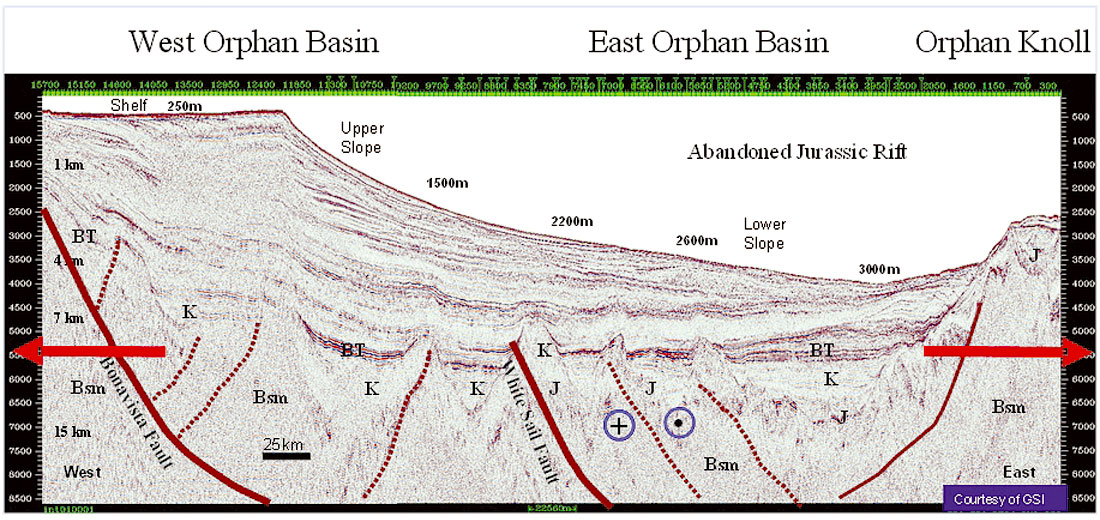
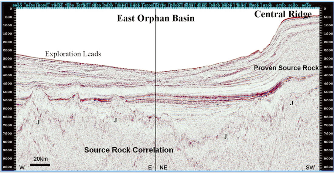
Prior to the initiation of Mesozoic rifting the area of study was part of a broad Palaeozoic sedimentary platform within the Avalon terrane of the Appalachian orogenic system. Seismic stratigraphic relationships indicate that the first phase of rifting began in the Triassic, and affected only the eastern side of the Orphan Basin (“East Orphan Basin”) (Figures 3 to 5). This initial northeast-southwest, narrow rift expanded during Late Triassic-Early Jurassic within the Tethys rift system which extended from the Gulf of Mexico to the Barents Shelf and Northern Europe. After a long thermal-subsidence stage, the newly formed rift basin was reactivated, enlarged, and deepened during the Late Jurassic-Early Cretaceous Atlantic rifting phase. At that time, the East Orphan Basin was connected with other North Atlantic areas of known source rock and reservoir deposition, including: the oil-prolific Jeanne d’Arc Basin to the south, the source rock- proven Flemish Pass Basin to the southeast, and the petroliferous Porcupine Basin to the northeast. Extension and minor transtension, continued during the Aptian-Albian (Labrador) rift phase and into several Late Cretaceous and Tertiary extensional episodes. As a result, the architecture of the basin is dominated by alternating ridges of basement blocks overlain by sediments and deep sub-basins, which are predominantly oriented northeast-southwest or north-south, and reminiscent of the Basin and Range structural style seen in the south-western United States. The ridges within the Orphan Basin are very large and have comparable size to the Central Ridge which forms the eastern boundary of the Jeanne d’Arc Basin, and some of the individual sub-basins within the Orphan Basin are of comparable size to Jeanne d’Arc Basin itself (Figures 3 to 5).
Structural Setting
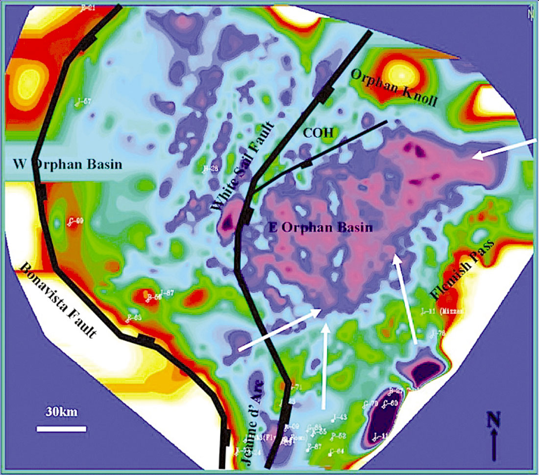
Considering tectono-structural factors and from the point of view of petroleum potential, the Orphan rifted area can be subdivided into (Figure 3 to 5):
- an older East Orphan Basin, which is a Tethys rift stage remnant with Jurassic (and probably Triassic) and Cretaceous sedimentary fill, situated in deep water (1,500-3,000m) and is likely to be oil and gas prone, and
- a younger West Orphan Basin, which evolved during the North Atlantic and Labrador rift stages containing mostly Cretaceous sedimentary fill, situated in shallower water (1000- 1,500m) and which is likely to be gas prone.
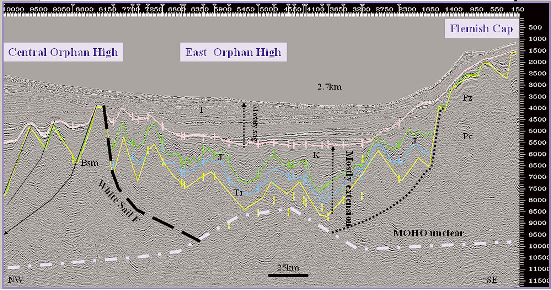
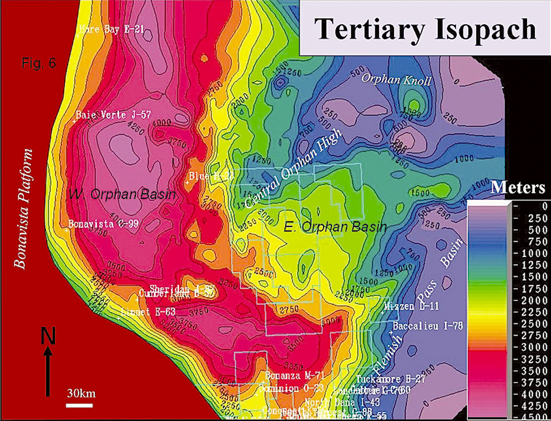
Tertiary cover is thick (4 km) over the W. Orphan Basin and relatively thin (2 km) over the E. Orphan Basin (Figure 6).
The two main rift basins, East and West Orphan, are separated by a major crustal fault zone, the White Sail fault which dips eastward and penetrates deeply into the upper crust. The N020° linear, tilted faults blocks identified within the West Orphan Basin run perpendicular to the flow-lines of the Flemish Cap motion during the M25-M0 period, providing independent evidence in support of the Flemish Cap/North America reconstruction at chron M25 which has been primarily derived from magnetic and gravity data (Figure 7). On the M0 reconstruction, the East and West Orphan basins are located directly in line with the Porcupine Basin and Rockall Trough respectively.

Paleo-reconstruction suggests that Flemish Cap behaved as a large, monolithic continental block that underwent a clockwise rotation of 43°, during the Late Triassic-Early Tertiary, which was accompanied by an apparent south-eastward displacement of more than 200 km. The associated stretching of the upper crust of the East Orphan Basin is observed to have a β = 2.5 (Figure 7). Regional seismic data suggest that trans-tensional movements, although hard to identify on reflection data, played an important role in the evolution of the basin and continued until the Paleocene. Beyond the Orphan Knoll- Flemish Cap “Outer Ridge” lineament lies a true divergent margin basin showing little deformation within the sedimentary sequence and which overlies a relatively wide continent-ocean transition zone.
Petroleum Potential
Excluding the Orphan Knoll which has a thin Mesozoic section, and several of the elevated basement blocks devoid of Mesozoic sediments, the entire Orphan Basin has hydrocarbon potential. However, neither major shows, nor mature source rocks were encountered in the Orphan Basin in any of the seven wells in the exploration cycle that ran from 1975-1985. Nonetheless, good sandstone reservoirs were found in the Late Cretaceous and Tertiary formations. Additional evidence of reservoir potential was encountered in DSDP # 111 on the Orphan Knoll which cored Bajocian-aged alluvial sandstones, the older syn-rift Mesozoic rocks drilled in the basin (Figure 2).

Late Jurassic paleogeographic reconstructions show the East Orphan rifted area as part of a larger regional rift system that included the basins of the Grand Banks and west Irish margin, where the presence of high quality Jurassic oil and gas source rocks have been proven by drilling (Figure 7). Additionally, Midto Late Cretaceous (post-Aptian) seaway extended from the Grand Banks into the Orphan Basin, and branched into northern Europe and the Labrador area (where deposition of Bjarni Formation and Markland shale gas-generating source rocks occurred). It is also noteworthy that Mid-Cretaceous (Aptian – Turonian) source rocks account for more than 25% of world’s petroleum reserves and that the entire Orphan Basin contains significant intervals of Mid-Cretaceous marine rocks.
Based on the age of basin fill, the presence of source rock, the timing of maturation, and seismic character correlation to adjacent basins, the Orphan Basin is predicted to be primarily oilprone in its eastern part, and largely gas-prone in its western part. The East Orphan Basin (Figures 3 to 5, 8 and 9) is under active exploration, while there are no blocks currently under license in the West Orphan Basin.
Important points to consider regarding the Orphan Basin petroleum potential include the following:
- Seismic data indicates that there is presently no total separation between the Orphan Basin and its southern neighbours - the Jeanne d’Arc and Flemish Pass basins (Figure 5). Several Jurassic-aged sediment-filled troughs show communication between basins across the Cumberland Belt fault zone. These have existed since the Jurassic, and possibly earlier. In its northern part, the Flemish Pass Basin appears as a higher terrace of the larger Orphan Basin.
- Several key wells, Panther P-52, Baccalieu I-78, and Mizzen L- 11, encountered thick Kimmeridgian-age source rocks (Egret Member of the Rankin Formation). They are located up-dip of and in areas connected to the Orphan Basin (e.g. Figure 9). Oil was also detected on logs by Petro-Canada et al. at Mizzen L-11. The Egret Member sequence penetrated in these wells can be easily correlated along seismic lines running into the licensed area of the Orphan Basin.
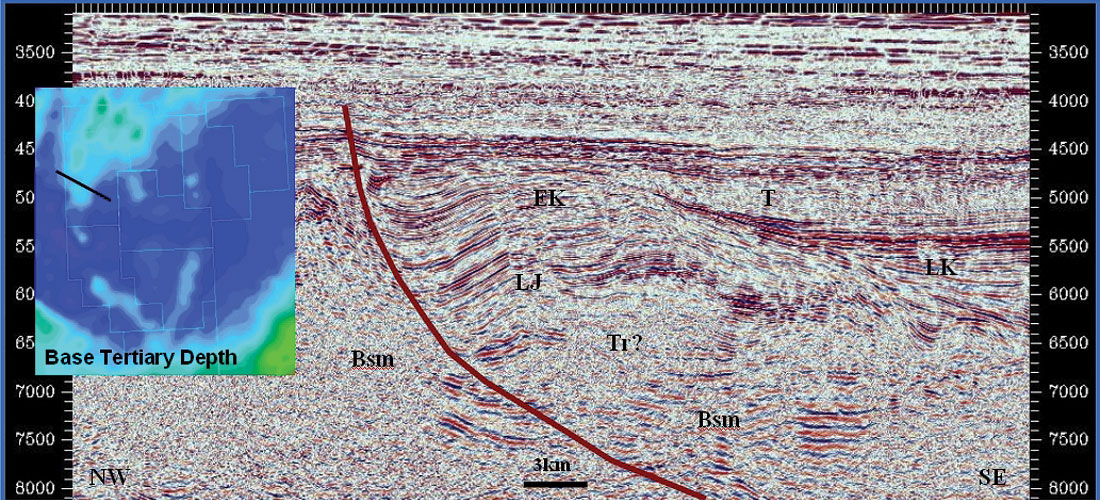
- Structural closures with areas between 200 and 400 km2 have been mapped in the East Orphan Basin. They are extensional anti-forms modified by transtension and inversion. Not all of them lie within the area licensed for exploration and may thus become available in future landsales (Figures 3, 4, 8 and 10).
- Seismic data show a series of complex features that cannot be explained strictly by dip-slip extension. Structural features vary from small inversions on fault planes to complex faulted anticlines and flower structures. They can be best described as compression modified extensional structures (CMES). In the absence of plate convergence in the area, oblique-extensional slip, transfer faulting, microplate interaction, megaplate realignment, rotation of the extensional vector, post-rift gravity detachment and ridge push can be considered as sources of the required compressional stress.
- As indicated by seismic character and amplitude changes, there is a high-probability of coarse siliciclastics being present in the basin. These are interpreted to be derived from the Bonavista Platform, Flemish Cap, Orphan Knoll, southern Labrador and Greenland areas, and the numerous local basement highs. Good-to-excellent Cretaceous sandstone reservoirs have been drilled in the Bonavista C-99, Linnet E-63, and Blue H-28 wells and in Flemish Pass and Jeanne d’Arc basins. Carbonate reservoirs of the Paleozoic “basement” have also shown reservoir properties in wells drilled in the Hopedale Basin, offshore Labrador, just northwest of Orphan Basin.
- Basin margin and basin-floor siliciclastic fans of Late Cretaceous and Tertiary age were derived from platforms and ridges and may be charged with hydrocarbons from postulated Albian, Late Cretaceous or Tertiary source rocks (equivalents of Bjarni Formation and Markland Shale of Labrador basins). They are the most obvious undrilled play-types in the West Orphan Basin.
- Numerous shallow and deep direct hydrocarbon indicators (including dramatic gas chimneys and numerous amplitude anomalies) are seen on modern 2D seismic lines. One explanation for the presence of enigmatic deepwater seabed geomounds on seismic data identified on the Orphan Knoll considers the possibility of a concentration of marine life near hydrocarbon seeps along deep-seated faults.
During the Late Jurassic – Early Cretaceous Atlantic rifting phase, the East Orphan Basin was connected with Jeanne d’Arc, Flemish Pass basins to the south and Porcupine and Rockall (eastern part) basins to the northeast. An excellent, oil-prone source rock was deposited in the neighbouring Jeanne d’Arc Basin that changed world-class hydrocarbon accumulations such as the Hibernia, Terra Nova, White Rose, and Hebron-Ben Nevis fields. Analyses of oils from the Jeanne d’Arc, Flemish Pass, Porcupine, and Celtic Sea basins indicate genetic geochemical links confirming geotectonic connection between conjugate margin basins.
Large 3D surveys were carried out in the past two years by an exploration partnership that includes Chevron, ExxonMobil, Imperial Oil and Shell Canada, are focussed on eight large exploration licenses awarded in the 2003 land sale in the East Orphan Basin. Exploration drilling in what will be record water depths for Canada (2300m) is expected to begin during 2006-2007.
Conclusion
Based on tectonic reconstruction considerations, it is proposed that the Orphan Basin can be subdivided into two large sub-basins which are divided along the White Sail Fault Zone. In consideration of seismic correlations with adjacent basins it would appear that the East Orphan Basin is likely to contain Kimmeridgian oil and gas prone source rock as has been encountered in the Jeanne d’Arc and Flemish Pass Basins, and the west Orphan Basin is more likely to contain Mid-Cretaceous gasprone source rocks as have been encountered on the Labrador Shelf. It is also postulated that during basin evolution, the Flemish Cap continental block underwent clockwise rotation and was displaced south-eastward approximately 200km.
Large basement-cored ridges and domes overlain by syn-rift sediments or rollover anticlines in the downthrown blocks of major faults, some modified by compression, provide very large structural traps within the East Orphan Basin, which are likely to be sourced from Kimmeridgian shales (Egret Member equivalent). Platform and ridge-derived siliciclastic fans of Late Cretaceous and early Tertiary age, with hydrocarbons sourced from a postulated Albian or Late Cretaceous-early Tertiary source rock present a very significant undrilled play in the West Orphan Basin. Petroleum potential of the East Orphan Basin will be tested by a deepwater drilling program (3-8 wells) that is expected to begin in 2006-2007.

Acknowledgements
Paul and Davey Einarsson, Geophysical Service Incorporated (GSI) for a unique and generous seismic data donation to Memorial University, John Hogg, Sam Nader, Ian Atkinson, Phonse Fagan, Gerry Smee, Kevin Meyer, Garth Syhlonyk, Hugh Wishart, Jonah Resnik, Jean-Claude Sibuet, Shiri Srivastava, Don McAlpine, David Hawkins, David Brown, Jim Wright, Hugh Miller, Tim Thomson, Pan-Atlantic Petroleum Systems Consortium for student funding, Memorial University of Newfoundland, Landmark Graphics (HC), Husky Energy, Petro-Canada, and especially Chevron for an industry grant to Michael Enachescu. I also acknowledge NSERC and Petroleum Research Atlantic Canada Consortium (PRAC) that each contributed funds to me and graduate students involved in the Orphan Basin research project: Steve Kearsey, Victoria Hardy and Renee Ferguson, who are also thanked.


Join the Conversation
Interested in starting, or contributing to a conversation about an article or issue of the RECORDER? Join our CSEG LinkedIn Group.
Share This Article