Summary
Two structures G and H in an Indian offshore basin were test drilled for Eocene prospects. The G-1 well turned out to be dry, but the H-1 well encountered a thick column of oil in Eocene limestone reservoirs. Following the discovery, a review interpretation of seismic data for detailed reservoir mapping was undertaken, which on close examination, indicated specious seismic anomalies, that would have significant impact on the economics of the field.
Earlier mapped ‘time lows’ to the north and west of the small sized oil bearing structure were suspected to be artifacts due to low velocities, associated with a ‘channel cut and fill’ feature in the overlying thick Miocene carbonates. Properly corrected for the velocities, the depth map indicated a large structure, much disparate from the time map. A subsequent well drilled based on the new map confirmed the seismic picture. Consequently, the reservoir geometry and the estimated oil in place showed a marked upward change in figures which upgraded the marginally economic prospect to a major high value field.
Introduction
‘Pitfalls in seismic interpretation’ (Tucker 1973) and ‘Pitfalls revisited’ (Tucker 1982) are two SEG publications which have been very popular with both geologists and geophysicists the world over. Tucker’s treatise on seismic artifacts, though fascinating, lacks, for whatever reasons, application in real case histories, without which, it becomes difficult to appreciate their value engineering aspect. The exploration industry has since been highly commercialized and examples of pitfalls discussed without relevance to their commercial application and consequent benefits tend to become prosaic.
Of all the categories of pitfalls in seismic interpretation, the most elementary but important is the one related to velocities. Seismic sections are still presented in travel time and for valid depth sections, it is sine-qua-non to have a precise and detailed knowledge of velocity. It is here, the geophysicist plays a very vital role in estimating an accurate velocity field for transforming the seismic times to depth. Needless to say that often a small discrepancy of the order of 10 m in depth estimation can make a tremendous pecuniary impact (of the order of several hundred millions of rupees) on the commercial aspect of the prospect.
Not many cases of seismic artifacts have been reported in journals where their application had a direct and/or immediate impact on field economics. We, however, present here a case study, where the identification and treatment of a velocity related seismic artifact have played a vital role in the turnaround of a successful development of a field.
The case study
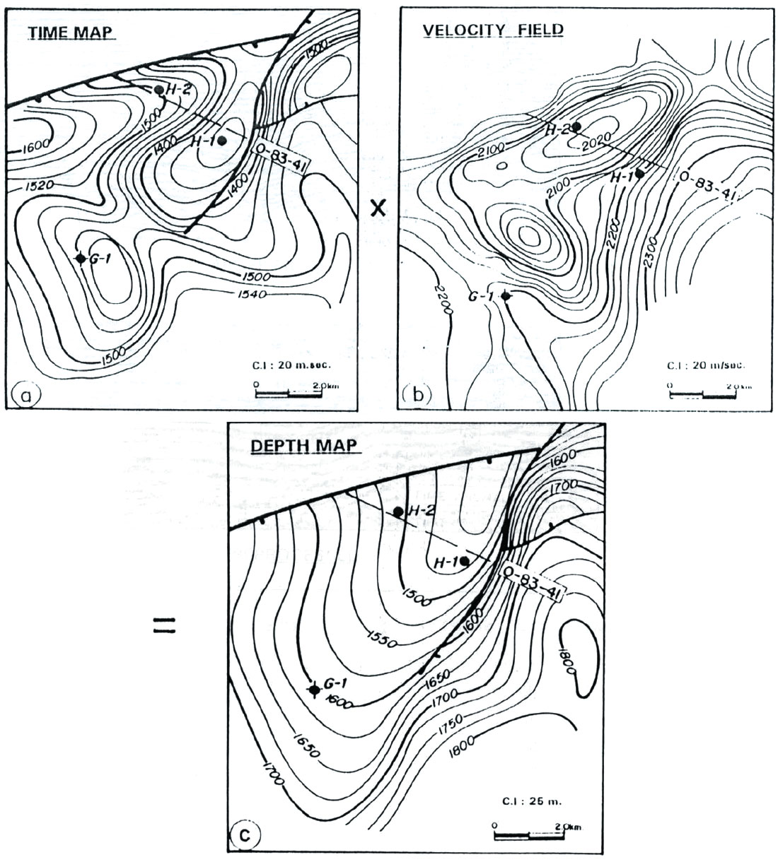
Two offshore structures G and H, close to each other but separated by a small low as indicated by the seismic time map (Figure 1a) were drilled for Eocene hydrocarbon prospects. The first well G-1, though turned out to be dry, indicated presence of thick highly porous reservoir facies within Eocene carbonates. Pursuing the lead, the structure H was drilled, about 100 ms updip and encountered a thick column of oil in the limestone reservoir.
The velocities at both the wells indicated the same value of 2200 m/s and a depth map earlier made (not shown here) on the single velocity function produced a map very similar to the time map indicating limited oil reserves restricted to the small area of structural culmination only.
Subsequently, a review interpretation of the 2D seismic data for detailed reservoir mapping was taken up for assessing the commercial viability of the prospect for development. The study exposed time anomalies related to severe lateral velocity variations, which needed corrections for preparing an accurate depth map at pay level.
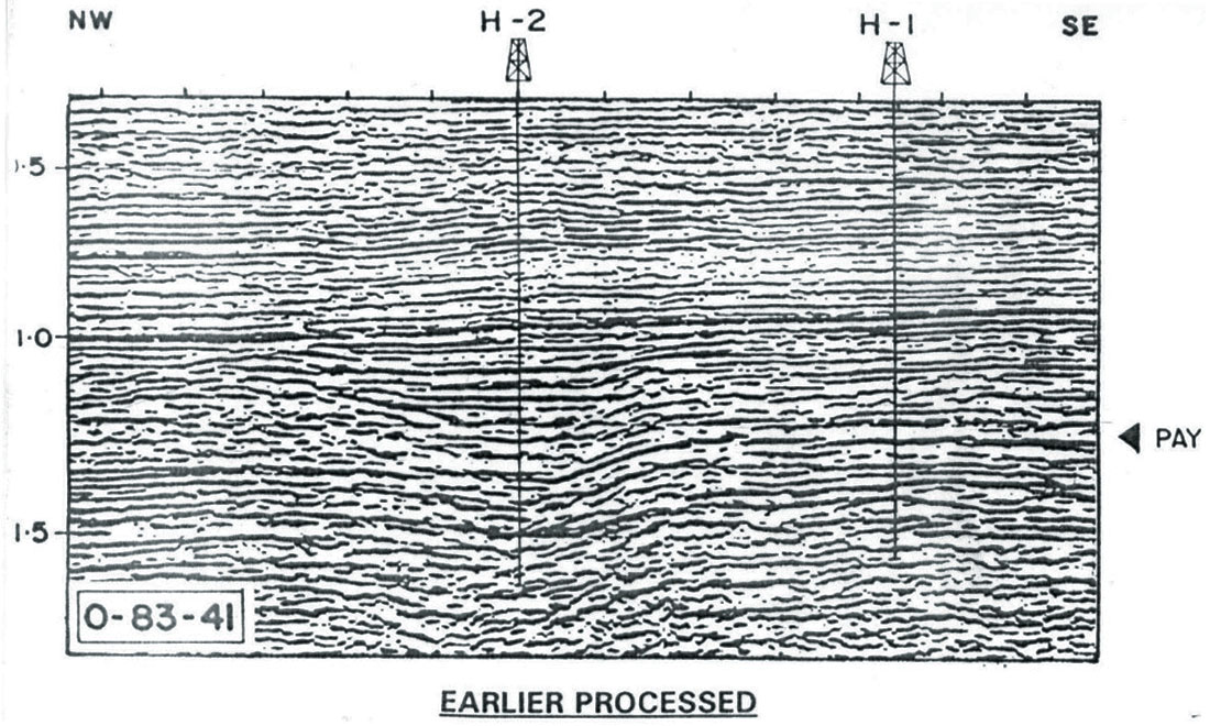
On a typical seismic section O-83-41 (Figure 2a) across the ‘H’ structure, a sag between 1.05 – 1.25s in the central part was interpreted as channel feature. The geometry of the sag, the high amplitude flat reflection segments within it and the related edge diffractions led credence to the interpretation. However, the sag seen at the deeper pay level was doubted to be genuine as it was seen right vertically below the channel and this necessitated reprocessing of the seismic data for authentication.
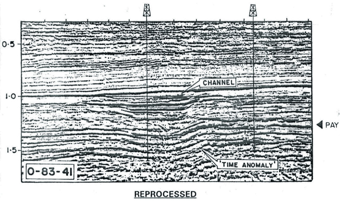
The reprocessed seismic data ( Figure 2b) clearly defined the ‘channel cut and fill’ geometry at the shallower level. The stacking velocity analysis also indicated significantly lower velocities associated with the channel fills. Erosional cuts in the younger Miocene carbonate shelf-filled with low velocity shale were known a geological entity in the nearby area and validated the sag seen on the seismic section at the pay level as an artifact.
An isovelocity map at reservoir level (Figure 1b) prepared fro m reprocessed 2D stack velocity data after calibration with the values at the drilled wells, showed strong resemblance of trend with that of the time structure map. The stacking velocity values at the sinks below the channel incision were further confirmed quantitatively by computation, taking into account the depth of the channel incision, the velocities of infill shale and the surrounding limestone.
The depth map (Figure 1c) prepared with the computed velocity field indicated radical changes. The apparently innocuous lows to the west and south of the high seen on the time map were transformed to features comprising the flank of a single large structure now formed by coalescence of the two earlier orthogonal ‘time highs’ indicated on the base map.
It was obvious that the new map indicated a large increase in the structural area as well as in the thickness of oil column which culminated in re-estimating the reserves many fold upward. An appraisal well H-2 (Figure 2) later ventured in the ‘time low’ area, confirmed the veracity of the seismic map and the increased reserves and was decisive in conversion of an economically lean prospect to a major high value field.
Conclusions
Velocity anomalies play a very crucial role in defining the geometry and structure of a reservoir and consequently in the hydrocarbon estimates and its economics. Careful examination and analysis of seismic data can expose apparently innocuous artifacts which may have strong impact on the commercial value of a prospect. The aberrations, however, can be obviated by the experience and expertise of a geophysicist.
In this case, a low velocity related seismic artifact at the target level caused by a channel in the overlying section, has been identified and its effect adequately corrected. This has led to significant economic benefit in turning around a near marginal prospect to a high yielding economic field.
Acknowledgements The authors would like to thank the management, ONGC, for permission to publish this work.


Join the Conversation
Interested in starting, or contributing to a conversation about an article or issue of the RECORDER? Join our CSEG LinkedIn Group.
Share This Article