This presentation summarizes some historical aspects of industry’s seismic exploration effort in the High Arctic. A range of seismic interpretation issues related to both geology and seismic data quality, as seen on different vintages and in various arctic regions, are discussed. Also highlighted are efforts of the GSC since 1984 to preserve and add to the knowledge base of High Arctic geology by using and valueadding to the legacy seismic data. These efforts include the current and planned activities involving seismic and geophysics within the Geo-Mapping for Energy (GEM) program of the current government of Canada.
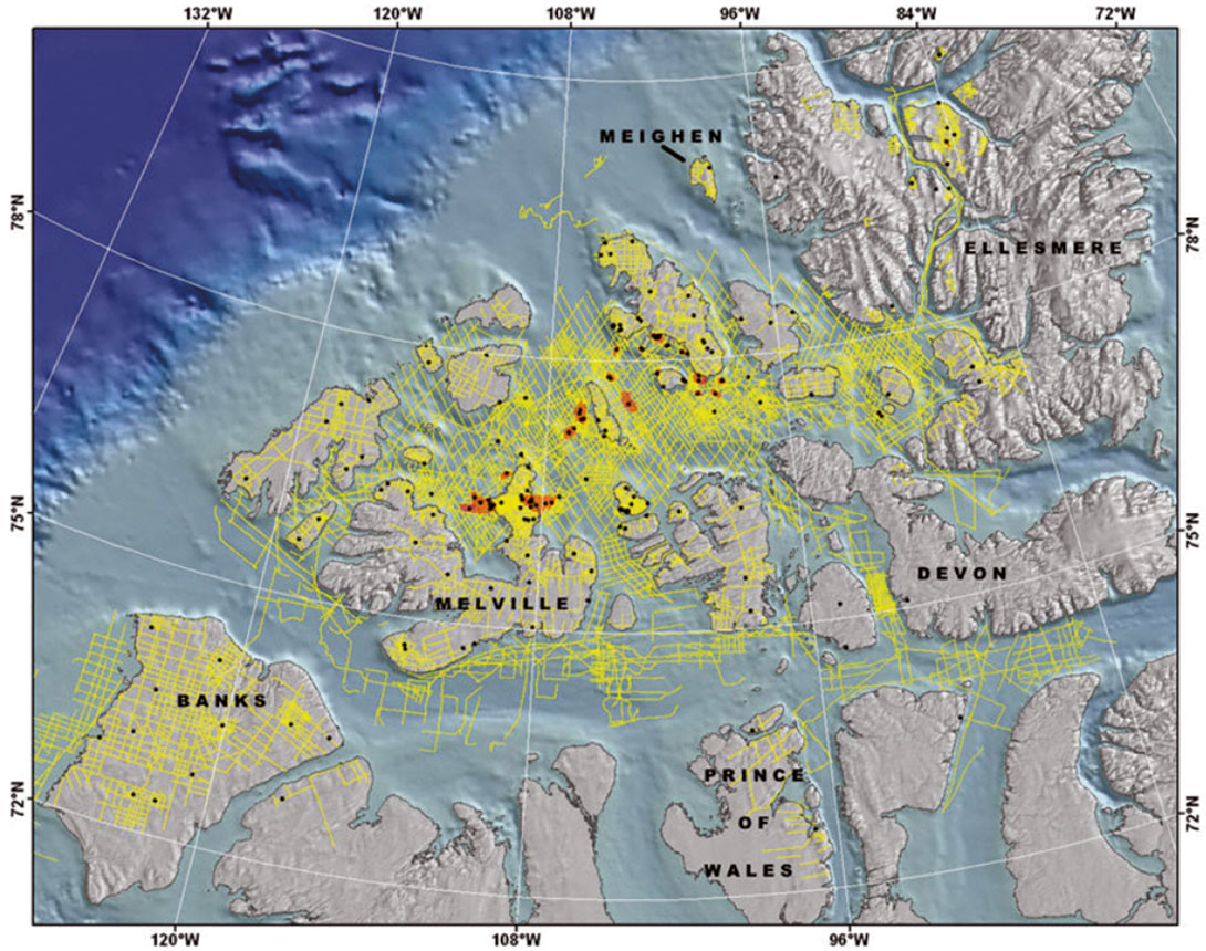
Petroleum exploration of Canada’s High Arctic began with a well drilled on each of Melville, Cornwallis and Bathurst islands between1961 and 1963. Seismic exploration however, lagged behind and Panarctic Oils Ltd. did not shoot the first line, north from Marie Bay on Melville Island until 1968. Years of seismic acquisition ensued, encountering challenges of onshore permafrost and imaging through permanent multi-year sea ice. By 1986, 98,105 km of 2D seismic had been acquired (excluding Baffin Bay marine seismic) and 194 wells had been drilled discovering 8 oil and 25 gas pools (Fig 1.). The relatively low fold seismic data, along with the display and interpretation methods of the day, was able to define structural drilling targets both onshore and offshore.
Land-based seismic record quality is largely very good, despite the presence of permafrost. This is primarily because the permafrost in the High Arctic does not often have discontinuities introduced from top melting, or massive ice lenses, such as is the case in the Mackenzie Delta. Because of a lack of permafrost in the offshore High Arctic, processors needed to deal with the rapid decrease of permafrost thickness to zero, at, or near shorelines. Interpreters needed to recognize the resulting velocity anomalies which ranged from a few milliseconds to over 150 ms. This variation is largely a function of the age, porosity, and rock type. Statics were generally not invoked to correct the velocity anomaly, but rather to create a smoothed stack through the relatively narrow transition zone. Prospect maps of the day normally did not have this offshore velocity sag removed and some prospects which resided in permafrost transition zones were avoided (e.g., N.E. Lougheed Island and Sor Fiord on southern Ellesmere Island). These effects are still contained in currently compiled regional time structure maps illustrated here and although not critical in mapping high structural relief salt-cored features such as the King Christian gas field, are critical for subtler low-relief structures like those of the Maclean and Cisco discoveries. Permafrost-corrections for individual islands will be possible by performing spatial data integration work utilizing digital bedrock geology and frozen/unfrozen map unit velocity databases being built under GEM Energy.
Water depths in the inter-island channels of the Queen Elizabeth Islands range to over 600 m and the geomorphology has been influenced by ocean currents, ice scour, glaciation and glaciofluvial processes. Further east in Baffin Bay, seismic indicates the presence of ice-rafted sediments which can produce post-glacial sea-floor armouring. Data quality of offshore seismic profiles can vary greatly due to issues related to recording through variable thickness sea ice. Sea floor and ghosts multiples also can also be problematic depending on the marine environment (i.e., hard sea floor, short water period). Smooth, high impedance, shallow sea floor geomorphology produce the worst multiples and energy penetration. This, combined with variable sea ice thickness, can produce seismic imaging results from very good to dismal. The thinner and smoother the ice combined with geologic structure dissimilar to sea floor attitude, the better the seismic image. In areas of perennial multi-year ice, Panarctic modified receiver array implementation on ice seismic shooting (e.g., Cisco) beginning in about 1983, calling it “high effort” indicating the additional labour and expense to layout herringbone-style receiver arrays. Reprocessing of existing onshore and offshore data will likely provide more information but exploration for stratigraphic play types such as the flanks of Cape Norem structure, and plays under multi-year ice of the offshore Sverdrup rim, will need more consistent seismic imaging quality.
The initial processing and interpretation of this High Arctic seismic dataset largely pre-dated workstation display and inexpensive migration technologies. Interpretation generally produced reliable subsurface maps although detailed stratigraphic breakdowns were not common. Horizons, which could be correlated any distance, particularly offshore, were the Triassic Eden Bay or Gore Point Limestones and the Jurassic Sandy Point Formation and Jurassic King Christian Formation (or equivalent), which were often ghosted above one of the Triassic limestone markers. Regional maps including both new and legacy seismic interpretations have been compiled and form the basis for seismic-related baseline subsurface products planned as spatial datasets to be published as one of several GSC open files of the GEM Energy program.
Examples shown of profiles from this legacy seismic data feature; Paleozoic through Tertiary geology of the subsurface of Banks island; the Siluro-Ordovician platform carbonates and Neoproterozoic images from Prince of Wales Island, and a variety of images illustrating the Carboniferous through Cenozoic geology of the Sverdrup Basin.
This time capsule of reflection seismic data remains a critically important asset for the future of hydrocarbon exploration in Canada’s High Arctic. It requires careful review and integration with other re-assessed regional datasets, such as thermal maturity and geochemical data.

Acknowledgements
The author would like to acknowledge continued support of Suncor Energy (PetroCanada), ConocoPhillips Canada, Husky Energy, Imperial Oil Limited and BP Canada Energy for permission to show seismic data.


Join the Conversation
Interested in starting, or contributing to a conversation about an article or issue of the RECORDER? Join our CSEG LinkedIn Group.
Share This Article