Introduction
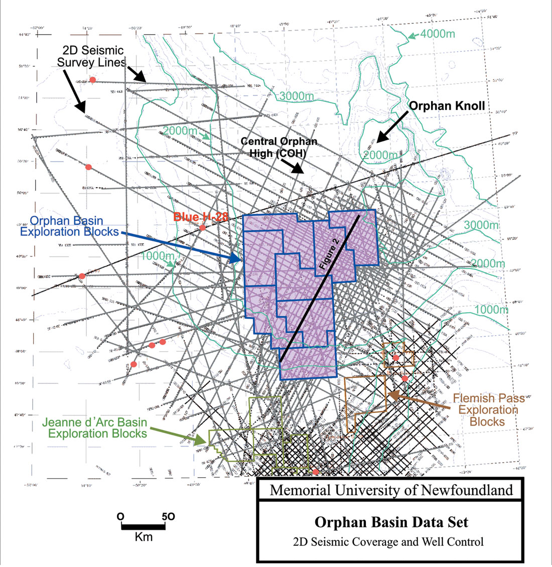
The Orphan Basin, located offshore Newfoundland and Labrador, is one of the largest under-explored basins along the eastern Canadian Margin. With large 3D seismic surveys executed in 2004-2005 and a deepwater well planned for 2006, the basin has become the new focus area for hydrocarbon exploration in Atlantic Canada. The basin formed during the Mesozoic rifting of Pangaea and Atlantic Ocean opening and had common evolution with the Jeanne d’Arc and Flemish Pass basins to the south and the Porcupine and Rockall Trough basins on the Irish Margin (Enachescu et al., 2006). The sedimentary basin fill consists of Mesozoic and Cenozoic strata that exceed ten kilometers in thickness in some places. Regional cross-sections reveal a thick Tertiary succession in the west, and a starved succession in the east (Enachescu et al., 2004). The Tertiary stratigraphy is presumed to be similar to that encountered in the Jeanne d’Arc Basin to the south, which consists mainly of deepwater siltstones and shales with local sandstone bodies (Deptuck, 2003).
Dataset
The Paleogene-Neogene (Tertiary) interval is clearly imaged in more than 25,000 line-kilometers of high-quality, 92-fold 2D seismic data that were recently (2000-2003) acquired by GSI and donated to Memorial University for research. These data provide an opportunity to separate the Tertiary interval into smaller subdivisions and identify regional sedimentation patterns. The seismic and palynological information of the deepwater Texaco Blue H-28 well (Koning et al., 1988; Geological Survey of Canada Basin Database), located in the western part of the basin, provides ground-truth for the interpretation of the Tertiary succession.
Seismic Stratigraphy
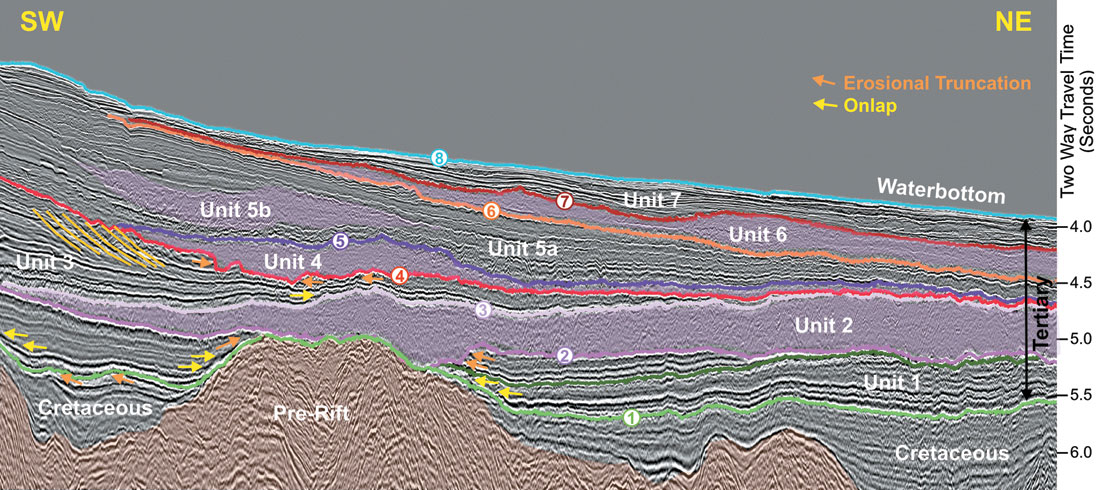
Eight seismic horizons, including the seabed, the widespread Base Tertiary Unconformity and a number of intra-Tertiary unconformities are interpreted throughout the 2D seismic grid. These horizons divide the Cenozoic succession into seven major seismic-stratigraphic units. Three of the mapped units (Units 2, 4 and 6) exhibit a chaotic low- amplitude internal acoustic character, and external shapes that are consistent with mass transport deposits. Mass transport deposits (MTD’s) are generally deepwater features that form through the mobilization or downslope movement of sedimentary strata and the re-deposition of the transported material (e.g., mass flows, debris flows, turbidites, submarine slumps and/or slides). MTD’s exhibit a seismic facies that is characterized by mounded external forms and hummocky to parallel low to moderate amplitude internal reflections that show poor continuity (Walker, 1992). In seismic profiles from this study, the interpreted MTD’s show local evidence of amalgamation of the deposits created by more than one failure event and/or possible fluid-escape structures at the top. One MTD appears to incorporate a displaced block at its base. The remaining seismic units consist mainly of alternating high- and low-amplitude parallel reflections.
Mapping Results
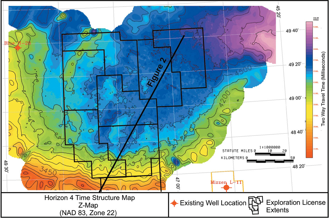
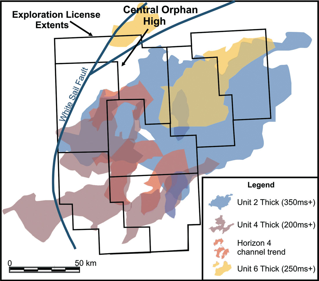
Time-structure and time-thickness maps reveal ancient seabed morphologies (e.g. Figure 3), the distribution of key seismic horizons and the thicknesses of units within the basin (Figure 4). The following observations are based on the preliminary maps:
- Unit 1 is thickest in the southeast and thins toward the northwest;
- Unit 2 exhibits a roughly sheet-like geometry that covers much of the East Orphan Basin floor;
- Unit 4 overlies a channelized unconformity (Horizon 4) and is thickest along the southwestern basin margin;
- Unit 6 consists of two discrete mounded deposits in the north (Figure 4);
- In general, the mapped MTD’s occur to the immediate east of the basin-bounding White Sail Fault.
Implications
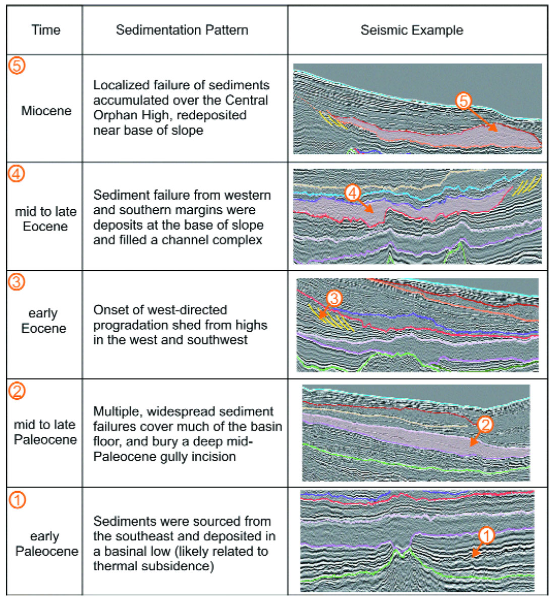
From these preliminary results, we conclude that the distribution of MTD’s and sediment pathways changed throughout the Tertiary. Sediments were likely sourced from the southeast and deposited in a basinal low in the early Paleocene. Multiple widespread sediment failures covered much of the basin floor and buried a deep Paleocene channel incision in the mid to late Paleocene. West-directed progradation began in the early Eocene, and by the middle to late Eocene sediment failures from the western and southern margins accumulated at the base of slope, filling a channel complex. Finally, in the Miocene, more localized MTD’s accumulated over the Central Orphan High. It is postulated that one or more of the mapped failure events were triggered by movements along the White Sail Fault and/or its imbricates.
Geohazards
A number of features identified in the dataset can be considered geological hazards and should be considered while drilling through the Tertiary section:
- Multiple large-scale failure events are p resent and may include internal erosional surfaces, displaced blocks, and/or overpressure conditions;
- Gravity-induced listric faults, which are present along basin margins and near the Central Orphan High might be accompanied by a broad spectrum of soft-sediment deformation and collapse structures (e.g., creep folds, buried paleo-fault scarps);
- Buried channels are present at several stratigraphic levels;
- Dense planar extensional faults are observed in some parts of Unit 5;
- Possible gas/fluid-escape structures or chimneys are present, and locally extend to the nearsurface. These features might be associated with fault planes that act as fluid conduits and they might also be linked to the presence of mounds at the seabed;
- Emergent and/or shallowly buried basement highs are locally present; and g) Shallow high-amplitude seismic reflections might be indicative of water- or gas-filled channels.
Conclusions
The Paleogene-Neogene succession in the Orphan Basin forms a thick wedge that is presently divided into seven seismic stratigraphic units. Mass transport deposits are present and reveal that a number of failure events occurred in the Tertiary. Relative dating indicates that large-scale failure events occurred during the Paleocene, Eocene and Miocene. One or more of these deposits might have been triggered by movements along the White Sail Fault, which bounds the western side of the East Orphan Basin.

Acknowledgements
Paul and Davey Einarsson, Ivan Sereda, Dave Taber, Bob Leatherbarrow and Louis Hebert, Sam Nader, Tony Kocurko; Michelle Martin, Steve Kearsey, Victoria Hardy, John Hogg, Satinder Chopra; Chevron Canada for an industry research grant, GSI for seismic data donation, Landmark Graphics for software and hardware donation, Petroleum Research Atlantic Canada (PR-AC) and Pan- Atlantic Petroleum Systems Consortium (PPSC) for research and study grants, Memorial University, C-NLOPB, CSPG and CSEG.


Join the Conversation
Interested in starting, or contributing to a conversation about an article or issue of the RECORDER? Join our CSEG LinkedIn Group.
Share This Article