Oil & Gas firms face the constant challenge of improving their success rate while lowering the cost and time required to achieve those successes. A significant influence on a firm's ability to achieve competitive advantage and success is the use of digital data within their processes.
Although implementation of digital data tools may not always directly benefit an organization, there are times when not implementing digital data will create a significant competitive disadvantage for that firm. Under these circumstances, digital data can be considered a "strategic necessity" for an organization (Clemons, 1991).1
The recognition by Oil & Gas firms of digital data's strategic importance has made it necessary for their service and product providers to rapidly incorporate technology into their processes and products.
As a result, seismic exploration has undergone significant changes. One of the important impacts on surveying and mapping capabilities has been the development of new technologies and, in particular, information technology. Technologies including Global Positioning System (GPS), geographic information systems, (GIS), enhanced computing power and data collectors have provided access to a broader range of means (methods, techniques, tools, etc.) for producing spatial data and information (Gagnon et aI., 1993).2
The adoption of these developments by the seismic industry has changed both the data available and how data is used. Individually, the tools have made a contribution; collectively, their influence on processes has been significant. As a result, digital information can be collected, processed, stored and transmitted faster and in greater quantities than was previously possible (McKeen & Smith, 1991)3
The seismic survey industry has developed considerable technical expertise in collecting and mapping spatial information.
The weakness that appears to exist is the reluctance to appreciate how industry strengths must be constantly recombined in different ways in order to provide added value for the customer.
There needs to be a reorientation within the field from "We know how to collect and process data well" to one of "We can apply what we know to what the customer wants."
No longer satisfied with individual products, customers now want solutions provided by interrelated products and services. Where firms could once narrowly define the market for their products, they can no longer work within those safe, static market niches.
Survey firms must now deal with both customers and competition who are embracing digital data and demanding new types of spatial information and new levels of information integration.
Various descriptions can be used to differentiate between data, information, and knowledge. They range from no distinction between data and information, to the separate use of all three. Inconsistencies arise from the many roles that the different elements (data, information, and knowledge) play. In this article, the terms will be used separately to avoid ambiguity.
Data consist of facts, measurements and collected observations, all of which can be considered inputs from different data channels. The problems of data (e.g., types, collection, processing, storage, visualization) are specific to different firms and organizations.
Information is the combination of data within a 'context-providing' model (King & Grover, 1991).4 Information allows answers to questions of the form "Where is the... ?", reducing uncertainty and possibly suggesting the need for specific actions.
Knowledge is the most difficult term to define. Knowledge is the synthesis of information and experience to answer questions of "What will happen if .. ?" and "Which alternative is best...?"
Often, the potential for organizational knowledge exists within a firm's information system structure but is not utilized for future decision-making due to the firm's inability to recognize or use it as knowledge. Knowledge is the goal being sought by the use of spatial information. When different forms of information are combined and related with spatial information, typically in a GIS, it is possible to provide new and potentially better forms of knowledge to use for decision making.
The relationship between these terms is hierarchical. Data is combined into information within a context-providing model, such as a map, to answer questions of an immediate nature. When combined with experience, information can be synthesized into knowledge for decision making. This process not only moves from data acquisition towards knowledge, it also contains connecting earlier stages in the process with later stages.
Firms must integrate data, information, and knowledge in new ways, and provide new ways for managing the new forms of integrated data.
Success in the seismic industry requires flexibility and a willingness to change. Success is achieved not only through static processes which, when implemented, result in greater customer value, but through the development of core competencies which are flexible and capable of changing according to customer requirements and market conditions.
To understand the spatial information needs of the customer requires an understanding of the marketplace. A firm must be able to understand the needs of the customer for the firm's product, as well as be able to account for the customer's needs from other areas of the industry.
This does not mean a firm must meet all of a customer's needs; it must anticipate the needs which can be met by other areas of the seismic industry and incorporate them into how the customer's spatial information requirements are met.
Prior to the 1970s, seismic firms were generally involved in a wide range of activities, often working in all fields related to seismic exploration, and few specialized firms existed in the industry. Technological developments for acquiring and processing data and information led to the development of specialized firms who dealt with specific areas of knowledge.
During the 70s and 80s, firms providing products for seismic markets were increasingly specializing in areas such as acquisition, processing, interpreting, etc. Seismic exploration has now moved to the point where firms cannot operate as isolated specialists in one field independently of other disciplines.
The focus on specialization as the key to success has become a barrier to future development. Firms that are too specialized can experience difficulties, because in addition to having specialty skills in one area, a firm must now understand how their products are interrelated with those of other seismic disciplines. In other words, seismic data products need to be integrated to meet the needs of the marketplace. This transition from the non-specialist firm to the integrated specialist firm is illustrated in Figure 1.
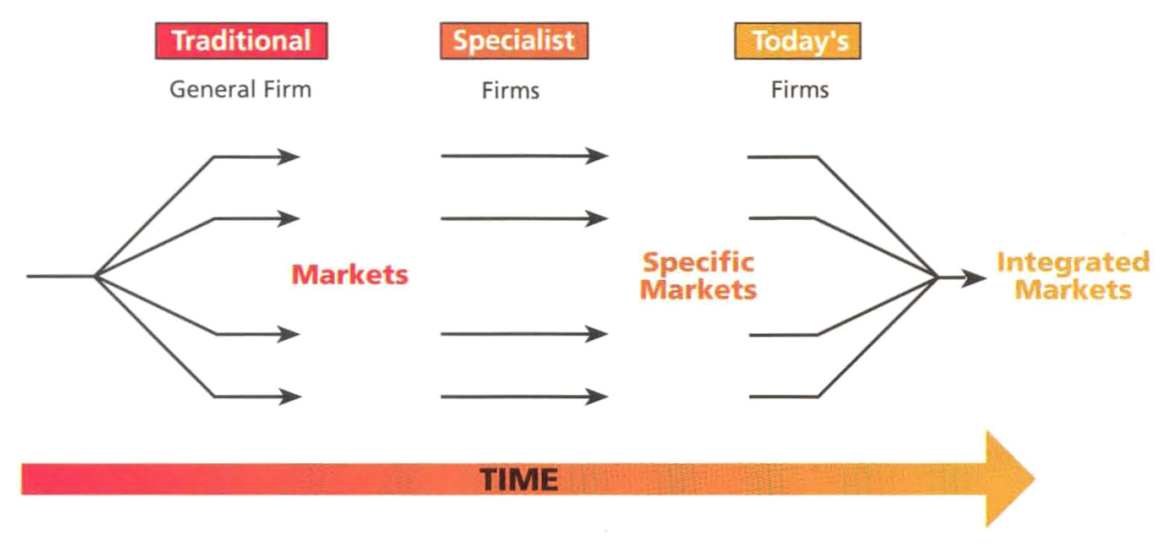
In addition to having specialty skills in only a few areas, firms must now understanding how their products are interrelated with those bing provided to their customers by other companies.
Achieving competitive advantage requires an understanding of how different areas of the industry are interrelated, how those parts can be made to interact in an optimal way, and what resources the firm possesses to meet the market's spatial needs.
Generally, an individual firm will focus on the needs of a few market segments. In spite of this narrow focus, it must be aware of its role in the process to develop the capabilities needed to achieve competitive advantage now, and so that it can foresee areas of competitive advantage in the future. A firm's products and/ or services need to be produced so that they are, or easily can be, integrated with other spatial information products. The only way to accomplish this integration is through the effective use of digital data.
Digital data affects a firm's performance by increasing productivity and increasing revenue. Digital data can increase productivity through reduction or elimination of labor costs and increase revenues through the creation of new and improved products and services to meet the changing needs of the marketplace. Thus, digital data contributes to an organization by increasing productivity, increasing the services and products offered, and providing better, in terms of timeless and quality, information for decision making (McKeen & Smith, 1991).3
Furthermore, digital data can create "virtual" integration whereby a specific process in the value chain is provided to the firm externally through a supplier of customer. The impact of digital data can extend to allowing some activities to be entirely bypassed and eliminated from a firm's value chain. If both the data source and the customer commit to using the same data and information structures, products can fit seamlessly into the customer's processes.
To take a practical look at how digital data has changed processes, specifically those affecting seismic programs, the "seismic cycle" has been segmented into three phases: design, implementation and analysis (see Figure 2).
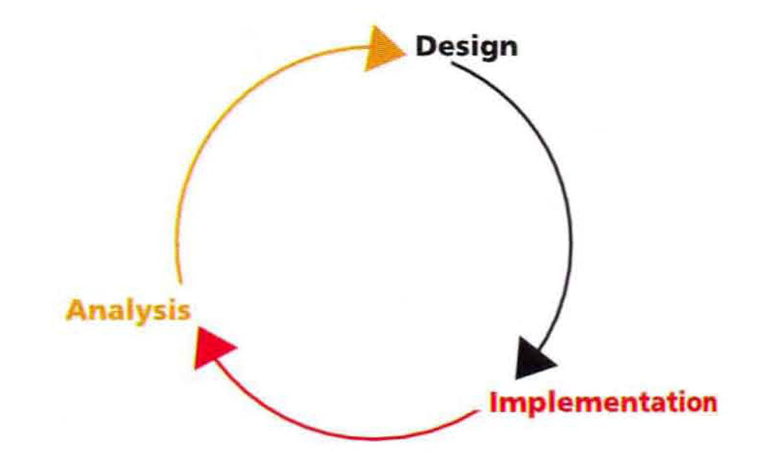
The three phases of the seismic cycle provide multiple opportunities for the same digital data to be utilized.
In this seismic cycle, data from a 2D survey will often be utilized to help identify the best location for drilling a well and/or for conducting a 3D survey in the same area. Data from a 3D may then be used to determine the extent of the pool and the best locations for subsequent wells.
The problems inherent to using only analog or "hard copy" (paper maps and reports) data when designing a seismic program are due to the limited information available for making decisions. There is insufficient data and no extensive knowledge of the program location prior to arriving at the site. Primarily, small-scale data is available (poor or no vegetation, no water wells, springs, dugouts, etc.) and, as a result, it is difficult to plan for time requirements, personnel & equipment requirements, costs, etc.
Typically, preliminary maps have been prepared using photocopied or blueprinted topographic maps with "taped" program lines. Until the survey actually begins, the surveyor has little or no information concerning the features that exist on the ground. Basic information such as roads, water, contour lines, etc. is generally available on initial maps.
The missing information such as building locations, pipelines, water wells, oil wells, gas wells, and transmission lines, to name but a few, must be collected in the field as the program is being surveyed. As a result, significant additional costs can be incurred due to changes having to be made with crews in the field waiting for decisions from head office.
A lack of digital data sets also increases the difficulty of finding and making sure of historical data for future decisions and planning. The analysis and data from prior work in an area can not be readily accessed when designing more programs.
Once the design phase has been completed and field activities begin the use of analog data poses further problems. One of the biggest challenges is the exchange of information between field crews at different stages of implementation. As surveyors complete their work and pass on data to drill crews, who then pass data on to the line crews, there are problems with data ranging from the legibility of faxes and sketches to who has copies of what information and how current is that information.
During the analysis phase of a seismic program, the analog data sets are cumbersome and difficult to integrate together. Data sets acquired during the design and implementation phases may not be available or are incompatible with seismic data and it is difficult to correlate surface survey data with subsurface seismic data. The selection of sites for further activity, whether seismic or exploratory drilling, once again begins a cycle of picking sites, going to the field, reselecting sites, revisiting the field.
Once the data has been analyzed and used for making decisions, the poor mechanisms for managing surveyed and seismic data sets pose another set of challenges.
The collection and use of digital data sets, however, has enabled process changes providing increased efficiencies and lower costs in all three phases of the seismic cycle.
At the design stage, digital data allows decision making based on testing alternate choices. A variety of secondary data sets are available from government and private sources, such as topographic maps, pipelines, oil & gas wells, digital aerial photographs, control point coordinate files, etc.
When assembled into a common data set, initial maps can be presented to geophysicists, problems can be detected at the early stages, and adjustments or redesign can take place prior to sending a crew to the field. Not only can existing site features be used when designing a program, geophysicists can also take into account any prior knowledge available from previous seismic work in the area. Portions of a map showing examples of this preliminary data is shown in figure 3.
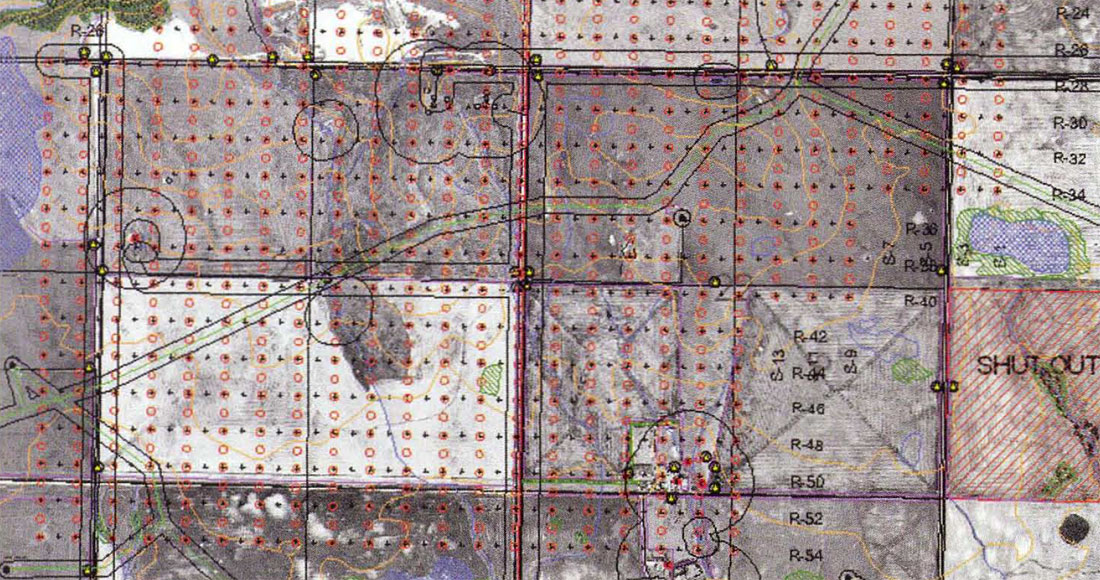
A typical Preliminary Access Map, displaying secondary data acquired from government and private sources, helps geophysicists identify problems and make pro-active, cost-effective decisions before field work has begun.
An example of the use of digital data sets providing an advantage is their use as part of the permitting process. When utilized by permitting agents, digital data allows them to acquire more accurate information in less time. As a result, better decisions can be made earlier in the program, the data can be passed on to the survey crew for further use, and there are fewer problems with unhappy landowners.
Today, when survey crews and, ultimately, seismic crew arrive at a program location, they have detailed, accurate maps and data files. Before the field surveyors even reach the program site, they are equipped with better initial information for surveying. In addition to utilizing the initial map prepared from secondary data sets, the surveyor begins to "fine-tune" the digital map information through the collection of primary data. Precise locations for wells, pipelines, bush, dugouts, etc. are collected by the field crews utilizing digital equipment and used to refine the existing map information.
The refined information is then used to generate the extents of exclusion zones required for seismic activities. Exclusions such as 180 meters for water wells and up to 45 meters for high-pressure pipelines, to name but a few, can all be automatically generated from the digital data sets. Once the exclusion zones are known it is possible to use shot and receiver point coordinates within skidding software to automatically generate skid lists for the field surveyors.
Upon completion of mapping and layout activities by the field surveyors, the digitally produced maps (see figure 4) are passed on to drill and line crews. The nature of the data sets makes it possible to readily produce maps customized to each type of crew's specific focus. Drill crews require maps showing all topographical features, hazards, exclusion zones, shutouts, access points, surveyed points; all of the features that they will run into on a specific program. Line crews, however, require less feature-rich maps: simply the program points as drilled, topographical features, program hazards and access points.
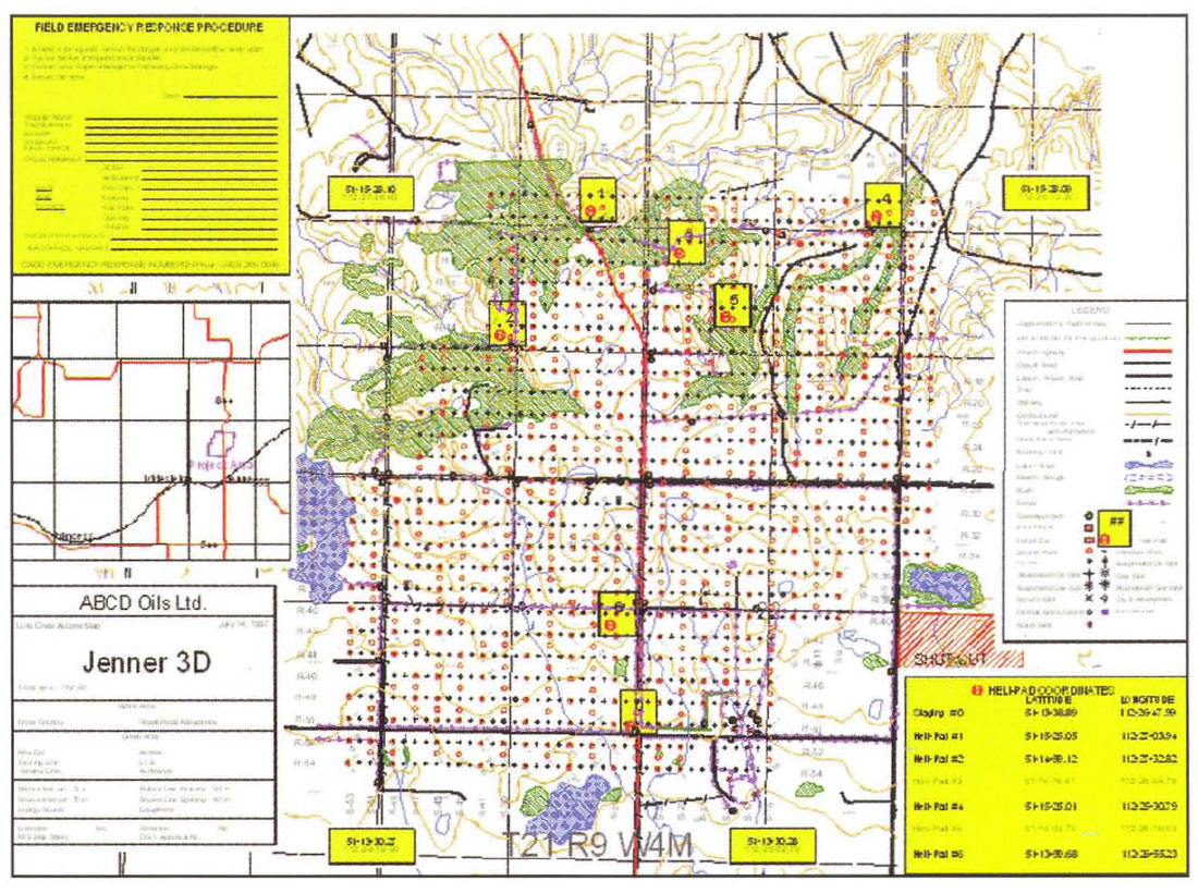
A typical Line Crew Access Map, displaying topographical features, program hazards, access points and program points as drilled, provides the line crew the information they need to know in one easy-to-use map. Additional information, such as the Field Emergency Response Procedure, access to the program, and heli-pad locations enhance the safety and efficiency of the line crew's operations.
Once the program is completed, geophysicists can be provided with a map (see figure 5) showing what data was collected where and, just as importantly, why.
Field conditions generally require modification of the initial theoretical design of a seismic program and, once the program is completed, the Geophysicist Map helps the geophysicist determine what modifications were made, why they were made, and how they will potentially affect interpretation of the collected data. In addition, the detailed mapping of surface features can be utilized to pick sites for exploratory wells.

The Geophysicist Map, displaying virtually all surface information pertaining to the program, helps the geophysicist determine what modifications were made to the theoretical design, why they were made, and how they will potentially affect interpretation of the data. This information can also be utilized to pick sites for exploratory wells.
As opposed to picking a site solely based on the interpretation of the seismic data interpretation, it is possible to determine whether proposed well sites are practical. For example, does the selected well site actually lie within a farmyard? Information provided digitally allows better decision making prior to sending personnel and equipment to the field.
Customers have also asked us for additional, user-specific maps. For instance, we provide some clients with pipeline information and/or maps based on data collected in the field with better than one meter accuracy. One reason for these requests is growing concerns about the deterioration of tracer wires in pipelines. Another reason is the ability for other departments in the company to utilize this information.
Digital data sets can be readily archived. As opposed to trying to store hardcopy maps, survey field notes, driller's reports, etc., it is possible to simply archive the data sets to digital tapes, CDs or some other near- or on-line storage media and re-access them on demand. Data sets can be readily copied for backup purposes or to provide the data to others.
The benefits of digital data to Oil & Gas firms and, consequently, to their service and product providers, can be readily recognized. Embracing digital data, however, requires change.
If firms are not flexible, there is a tendency to rest on past successes, avoiding change due to the perception that by changing to something new, a firm could lose what they already have. Reliance on existing competitive advantage, however, could leave a firm at a significant disadvantage in the future.
Both leaders and followers will have to continuously improve to keep up with the demands of the marketplace and the abilities of competitors to meet those demands. If a firm's focus is anchored on past resources and capabilities, opportunities arise for competing firms that approach the future more flexibly and imaginatively.
For example, the development of GIS has been one of the largest factors in the push for digital data and for developing a greater understanding of how the different disciplines and functions of the seismic process are interrelated. GIS enables different forms of spatial information to be combined and used by the marketplace for decision making in ways not previously possible.
If a firm does not develop expertise in GIS, or at least in processes and technologies that deliver equal or superior capabilities to utilize digital data, the result will be a loss of competitive advantage and, ultimately, the loss of business.


Join the Conversation
Interested in starting, or contributing to a conversation about an article or issue of the RECORDER? Join our CSEG LinkedIn Group.
Share This Article