Summary
The Haughton meteorite impact structure on Devon Island, Nunavut is a fascinating geologic site as well as one of the most Mars-like places on Earth. Similar, but not quite as harsh as Mars, the Haughton crater is cold (average temperature –17°C), dry, rocky, dusty, and windy. Dr. Pascal Lee, of the NASA SETI Institute, has led a program of exploration, research, and habitation to the area for the last 6 years. The goals of the Haughton- Mars Project (HMP) are to understand the biology and geology of this Mars analogue, in addition to learning how humans (and machines) can survive and work in such an environment. As part of the effort at HMP, the University of Calgary Applied Geophysics Group was invited to conduct geophysical surveys, both ground-penetrating radar (GPR) and high-resolution seismic, in the summer of 2002. Objectives of the geophysical work were to image the permafrost layer (Mars is thought to have a similar permafrost-type layer which could have been a source of water for ancient, and perhaps future, life) as well as assess deeper geologic horizons. Developing near-surface imaging techniques on Earth and applying them on Mars missions should assist in understanding Martian depositional processes, chronologies, and possibly life-related anomalies.
Surveying conditions at HMP can be severe due to the high winds of the polar area (up to 70 km/hr during this field survey), low summer temperatures (-5°C to +5°C), sleet, rain, and snow – even though this region is characterized as a desert – and significant ultraviolet radiation. GPR data were acquired using Sensors & Software NOGGIN 250 MHz system and PulseEKKO devices with 50 and 100 MHz antennae. These surveys imaged depths from about 0.5m to 3 m and indicate layering and permafrost events. High-resolution seismic results, recorded with an EG&G 60-channel recording system and accompanying 28 Hz omnidirectional geophones, also show the permafrost layer and deeper layers.
Shallow excavations, seismic refractions, and GPR reflections at the site all proved useful and indicate that the permafrost layer is at a depth of about 60cm. We also tested geophysical operations in prototype spacesuits and found the suits to be manageable although cumbersome. We plan on returning to the Haughton crater in the summer of 2003 for further geophysical surveying and system testing.
Introduction
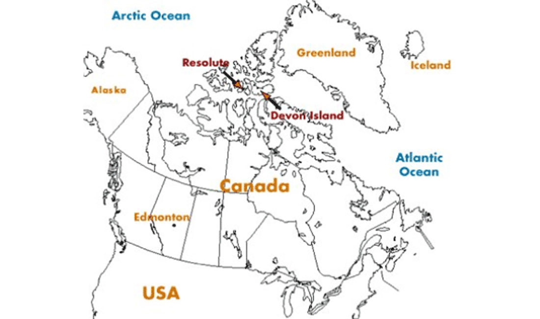
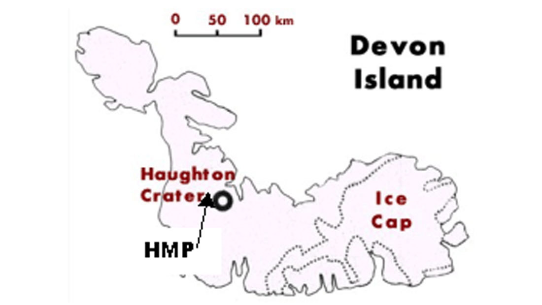
The planet Mars has long held our Earth-bound fascination. That interest is intensifying with the closest approach of Mars to Earth in millennia occurring this August. Three space missions (Nozomi, Mars Express, and Mars Exploration Rovers) and many more telescopes are all being excitedly directed toward the Red Planet. Understanding Mars and developing the technology to explore it have relied on many avenues of effort, including the use of Mars-analogue environments on Earth. The Haughton meteorite impact structure on Devon Island, Nunavut in the high Canadian Arctic (Figure 1) is one of the most Mars-like places on Earth. The Haughton structure, at 75°22’N longitude and 89°41’W latitude (Figure 2), is a 23 Ma old impact crater about 20 km in diameter (Osinski et al., 2001). Host rocks of the structure are of Ordovician and Silurian age, mostly of the Allen Bay formation (Scott and Hajnal, 1988). The impact has left a very impressive scar on the landscape as seen from an airborne radar image (Figure 3).
The northwest region of the outer middle rim hosts the base camp for the Haughton Mars Project (Long, 1999; Lee, 2002a;b;c). Geophysical surveying can be difficult, even in the summer on Devon Island, due to the high winds of the polar area (up to 70 km/hr during this field survey), low summer temperatures (-5°C to +5°C), sleet, rain, snow – even though this is characterized as a desert (Cockell et al. 2001), and significant ultraviolet radiation (Cockell et al., 2002).
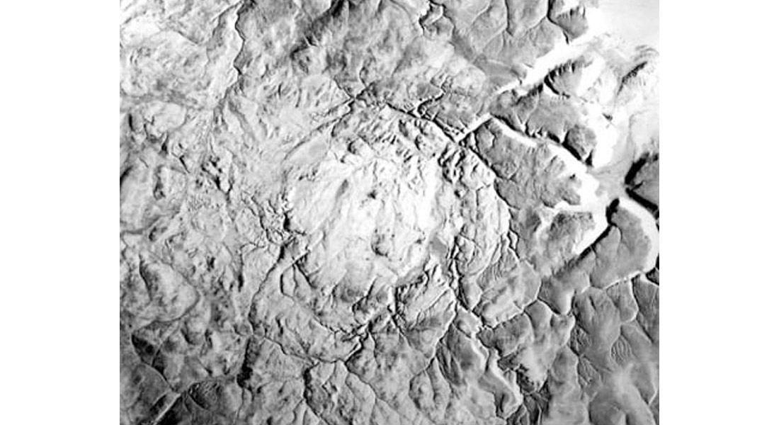
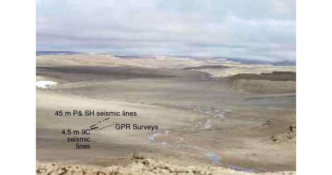
Figure 4 is a panoramic view of the HMP camp area with working and mess tents, living areas, and the Canadian Space Agency’s test greenhouse. Snowy patches remain even at this point (August) and the valleys are striped with snow and ice melt runoff. The “Von Braun Valley (VBV)” on the left of the Figure is the site of some of the GPR and seismic surveys.
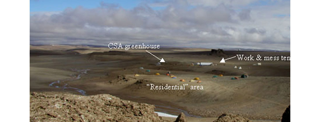
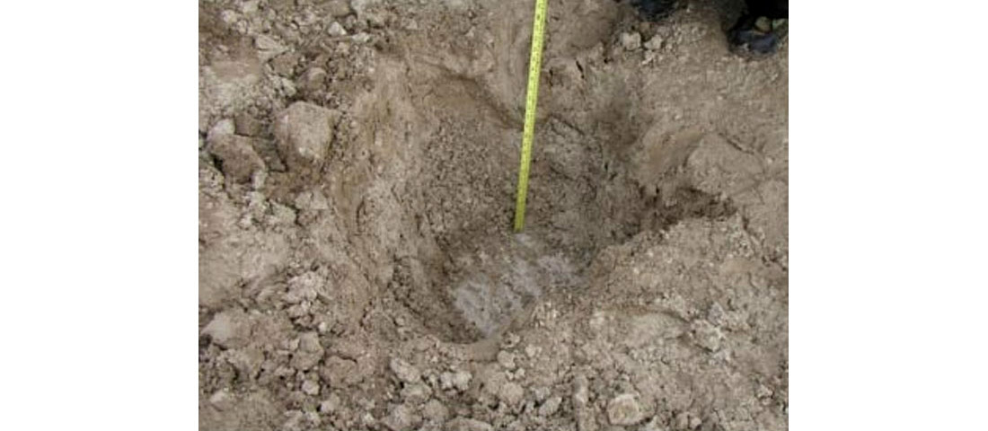
Figure 5 shows the site of the GPR and seismic surveys near the base camp. We conducted another series of surveys several kilometres away at the “Gemini Hills”, but only the VBV surveys will be discussed here. We dug several test pits (Figure 6) near the base camp to investigate the composition of the near surface. We found a tan-coloured, saturated silt with small clasts down to depths of about 45 – 65 cm. We then encountered solid and uniform permafrost with the appearance of frozen silt. The country rock into which the bolide (asteroid or comet) collided was a gently dipping (west) carbonate sequence of Ordovician and Silurian sediments (Scott and Hajnal, 1988).
Multicomponent Seismic Data
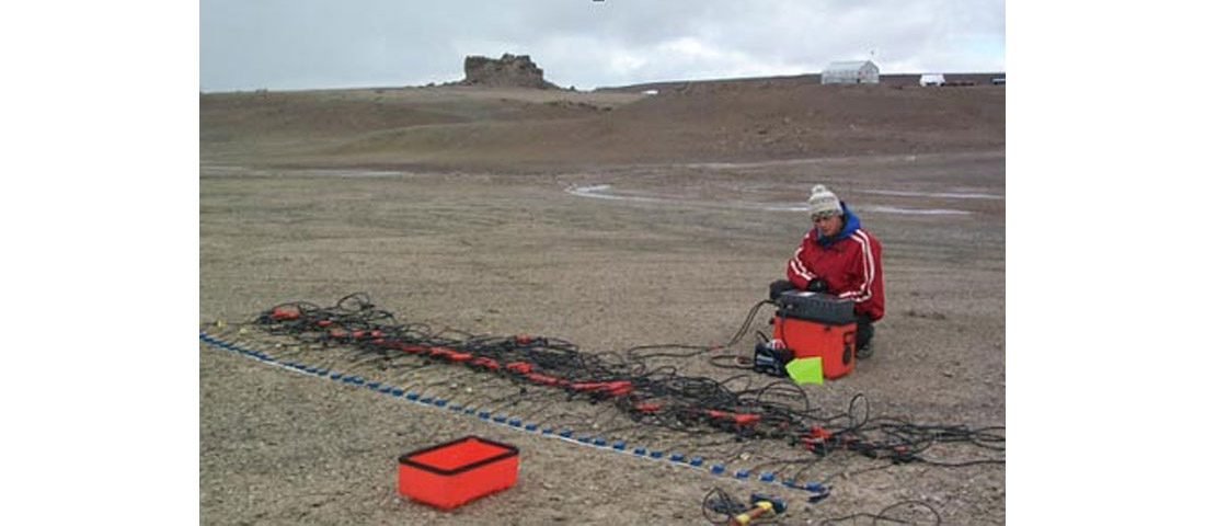
We used an EG&G Strataview 60-channel seismic recorder with 28Hz omni-geophones (planted in vertical and horizontal configurations). One of the seismic micro-spreads is shown in Figure 7. A small sledgehammer was employed as a source striking a base plate in either a vertical or horizontal direction.
We conducted a number of surveys using a variety of source-receiver combinations. That is, vertical source strikes and vertical receivers, horizontal hammer blows and transverse receivers, etc. A data example for a vertical hammer strike with horizontal, inline receivers (the P-S configuration) is shown in Figure 8.
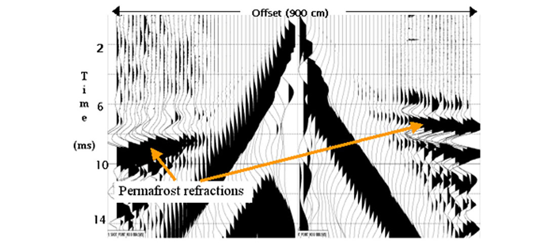
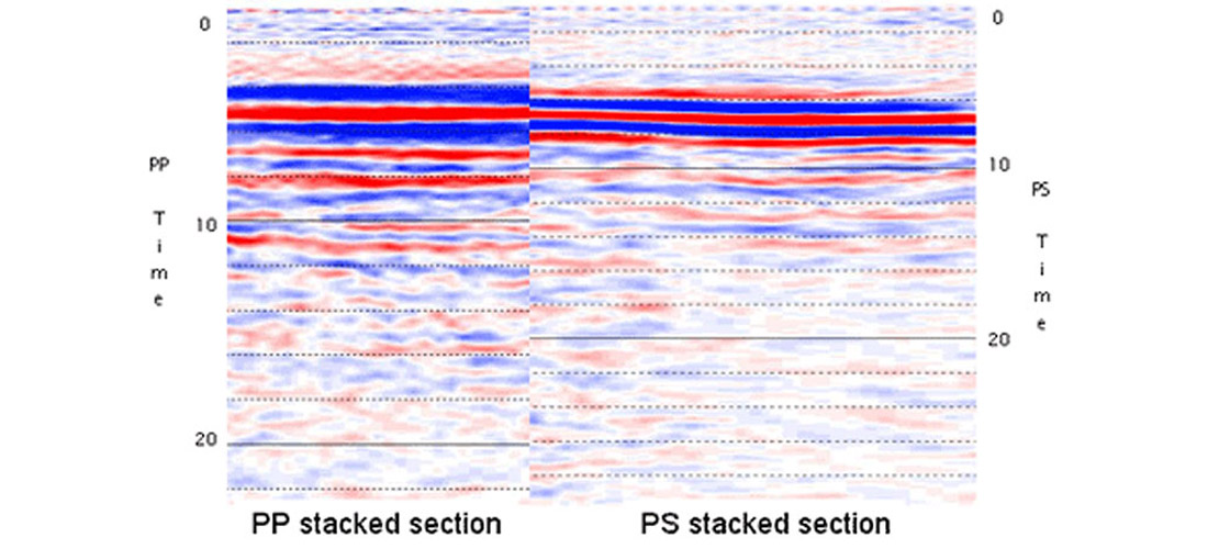
We are still analysing the seismic data, but have determined very low preliminary P and S velocities in the near-surface silts (260m/s and 168m/s, respectively) with very high velocities in the permafrost (P-wave velocity = 3100m/s, S-wave velocity = 2060m/s). We processed the PP and PSS refracted data (as it has very high amplitude) into stacked sections that are shown in Figure 9. We interpret the dominant event on both sections to be the top of the permafrost.
Ground Penetrating Radar
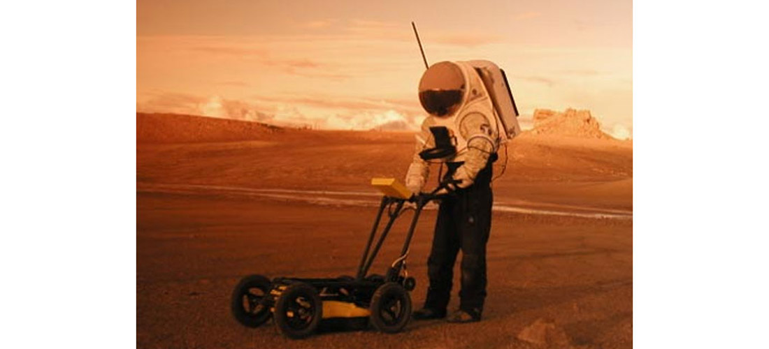
We also acquired a number of GPR lines in the Von Braun Valley. Use of the Sensors and Software NOGGIN SmartCart greatly simplified acquisition as one just rolls it across the surface and views a real-time display of the radar arrivals. Having a similar acoustic system would be a great stride forward in subsurface imaging. The NOGGIN system undergoing a Mars-simulation test is shown in Figure 10.
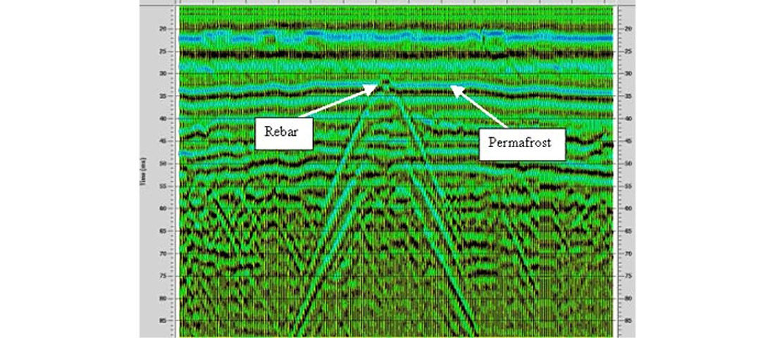
We also used a Sensors and Software 250 pulseEKKO system with 50 MHz and 100 MHz antennae in a walk-apart manner to determine radar velocity values. To assist with interpretation of the GPR data, we dug a trench down to the permafrost and pounded a 1m length of rebar into the end of the trench on top of the permafrost. We then surveyed orthogonally across the undisturbed ground above the rebar. This gave us a very nice signature of the rebar diffraction and helped determine the event to be interpreted as the permafrost top (Figure 11). We have experimented with a number of processing flows to find optimal filter, deconvolution, and migration parameters.
Conclusions
This paper provides a preliminary report of some of the geophysical findings of the HMP-2002 field surveys. Both seismic and GPR systems worked well in the field, under some harsh conditions, and provided useful information. Using test pits, reflected GPR data, and refracted seismic energy, we found the permafrost layer to be at about a 60cm depth. Conducting field operations in prototype spacesuits was cumbersome, but manageable. We plan to return to HMP in the summer of 2003 for further surveys and analysis.

Acknowledgements
We express our appreciation to the NASA Haughton-Mars Project and especially its principal investigator, Dr. Pascal Lee of NASA Ames. Thank you to Sensors and Software Inc. for loaning us their GPR systems. Many thanks to Eric Gallant and Henry Bland of the CREWES Project at the University of Calgary who provided logisitical support. We thank the University of Calgary (especially former Department Head, Dr. Don Lawton) for equipment support. We are grateful to NSERC for providing partial support for University of Calgary student, Robert Birch, via a summer fellowship. University of Calgary graduate students Ms Julie Aitken, Monica Moldoveanu, and Carlos Nieto have capably assisted in the analysis of these data. Geo-X Systems Ltd. of Calgary has generously provided expert processing of the HMP GPR data.


Join the Conversation
Interested in starting, or contributing to a conversation about an article or issue of the RECORDER? Join our CSEG LinkedIn Group.
Share This Article