WE WOULD LIKE TO THANK CURTIS FOR THIS PAPER ON GEOSTEERING. CURTIS WAS LET GO WITH THE DROP IN OIL PRICE AND IS CURRENTLY SEEKING NEW OPPORTUNITIES.
Gone are the days of old, when geosteering relied solely on drill cuttings. Advancements in drilling technologies have pushed laterals longer and deeper, and with faster drilling times. As these technologies advanced, so did the need for more accurate, real-time data from downhole, so the geosteering technologies and data collection tools kept pace. Azimuthal gamma, resistivity, image, sonic: the list goes on of logging tools available to operators during MWD operations. But how can these data be utilized by geophysicists? Geosteering is for geologists and drilling engineers, isn’t it? We’ll find that even the most common, basic method of geosteering with only a gamma tool can provide valuable information to geologists, geophysicists and our friends the engineers alike.
Before we dive into some key things to look for while geosteering, and some ways to extract data pertinent to a geophysicist, let’s discuss the basics of geosteering.
Steering 101: Data Collection
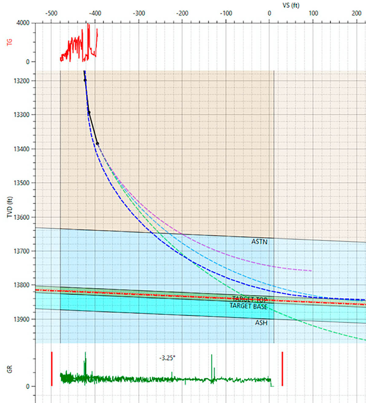
Real time drilling data is transmitted to surface via mud-pulse telemetry. A valve downhole is fluctuated to create pressure fluctuations in the drilling mud. These fluctuations travel uphole and are recorded at surface with transducers, and the downhole information is then reconstructed. Location of the drill bit/wellbore comes in the form of inclination and azimuth, which are recorded using magnetometers (using the Earth’s magnetic field to determine azimuth) and accelerometers (relative acceleration of the drillstring to determine inclination). So, we have the location of the wellbore in space, which is great! But where are we drilling? Are we in zone? Are we encountering any small faults? Are the localized bed dips the same as what we picked on our seismic? Are we above or below the thin impermeable mudstone that we cannot resolve in our seismic data? I’m getting specific here, but many questions like these come up during drilling, and knowing the location of the wellbore isn’t enough to answer them.
The Primary geosteering tool: Gamma
The most common tool used in modern geosteering is the gamma tool. It is robust, cheap, and provides valuable information about the lithology of where you’re drilling. Naturally occurring gamma radiation emitted by the rocks surrounding the tool are detected by the tool, and the data is transmitted to surface via mud pulse telemetry. As the well progresses through the vertical, curve, and lateral portions, gamma data received by the geo-steerer are correlated relative to a reference log, typically a gamma curve from a nearby vertical (there are other reference logs used, such as deviated wells converted to TVD, or logs derived from previously steered wells). By correlating back to your reference well, you can interpret where in the subsurface the bit is drilling, and if any changes to wellbore trajectory need to be made.
Data into Useful Interpretation
I don’t think I have ever steered a well where no deviation from the drill plan needed to be made, based on the data received. Not every play is a laterally continuous, thick reservoir, and thus wells can’t be planned and steered on “auto-pilot”. Often times dip changes predicted with seismic are encountered early or later than expected, so immediate inclination changes need to be made in order to stay in zone. The resolution (both horizontal and vertical) is not suitable for resolving a target zone of, for example, 2m in the Cardium, when resolution is (for argument's sake) maybe 8m.
Data as a Model Input
In areas without much well control, marker beds can be invaluable in verifying models by providing a TVD/TVDSS for localized bed boundaries. As the well progresses, the correlated data can provide depths to a boundary over a distance that spans the entire lateral. Rather than a single data point from a vertical well, you now have a series of data points potentially 3,4 km long, depending on your lateral. Comparing these depths to your seismic interpretation is very beneficial. How accurate is your velocity model, now that you have depth data several km away from any anchor point?
Expanding on the point above, marker beds that are strong reflectors are very useful, but what happens if one isn’t present near enough to your zone of interest, or you are interested in a submember of a formation (i.e. The Montney B, Lower Eagle Ford, Falher F, etc.)? Small layers of a distinct gamma character but not a large impedance can also provide insight. Taking the Austin Chalk for example, bentonite layers are very thin, but have a very high API value, which shows up distinctly when drilling the chalk. Because the bentonite appears due to ash deposition following volcanic eruptions, it is laterally continuous, and can be used as a reference depth to your zone of interest.
A Rotating Driller is a Happy Driller
Geosteering allows us to be proactive, looking ahead of the bit and making inclination changes preemptively. It’s very common to be drilling with inclinations slightly above or below local structure dips. Geo-steerers will notice the bit drifting slowly towards a zone boundary, and the rig can be instructed to change inclination accordingly. Small inclination changes made can be accomplished by sliding for less time and a smoother wellbore trajectory. This results in higher overall ROP and higher in-zone percentages, and the straighter wellbore makes it easier to get completions to reach bottom and keep the drill string rotating. Current lateral lengths combined with high ROPs create bottoms-up times that are measured in hours. This delay can easily result in lots of drilling out of zone and large slides to rectify that.
Gamma Expanded
While simple gamma is used most commonly, wells in new areas or trouble sections frequently will be drilled with additional data for the steerer. Azimuthal gamma is recorded using multiple sensors, to obtain gamma ray data for the full circumference of the wellbore in sliding or rotating conditions. Gamma image logs can be generated, making it much easier for the interpreter to distinguish layer boundaries where layers have a small API difference, and even to calculate apparent bed dips.
OK, We Get It, Gamma is Great. What Else?
While we only discussed gamma in this article, many other tools can be run in order to better drill a well. Resistivity logs can be very useful in SAGD applications in the oil sands, as the general goal is to avoid any channels where the reservoir fluid is water. The similar lithology of channels can make geosteering with gamma very difficult; however using resistivity to steer out of the wet zones is very advantageous.
Drilling rigs these days can send terabytes of data per day during drilling operations. Finding a way to utilize these data in all aspects of drilling results in reaching TD faster and more accurately, helps plan the next drills, increases our knowledge of the reservoir, and ultimately means better wells. Geosteering data and the interpretations it generates can aid in all of these goals.


Join the Conversation
Interested in starting, or contributing to a conversation about an article or issue of the RECORDER? Join our CSEG LinkedIn Group.
Share This Article