The exploration history of the discovery of two deposits beneath the Phanerozoic cover of the Flin Flon – Snow Lake volcanogenic massive sulphide (VMS) Belt in Manitoba and Saskatchewan is presented. Due to a lack of outcrops of the host rocks, geophysical exploration techniques were key to the discoveries. Both discoveries are attributed to geophysical techniques and both used arguably the best airborne electromagnetic technology at the time to detect the sulphide mineralization for ground follow-up and then drill testing. But it took many tries or near misses over a long period of time, either by other companies or by the discoverers in the same area, before the discovery hole was drilled. The exploration history of the McIlvenna Bay Deposit and of the Reed Mine Deposit are presented to show the perseverance required to find these deposits.
Introduction
The geosciences – geophysics, geology, geochemistry and supporting disciplines – have a long and storied history supporting resource exploration across Canada, and no more so than in the Prairie provinces. Many of us working in this part of the world think about petroleum exploration first, but there is much, much more.
Every geoscientist understands the control that geology exerts on almost every resource we extract from the earth. The rocks and sediments dictate not only the distribution and quality of subsurface resources such as minerals, petroleum, and water, but they also control where we can find building materials (sand and gravel), where our surface waters flow and accumulate, and even the nature of the soils that nurture our agriculture. In fact, the late AAPG Past-President James E. Wilson published a book entitled “Terroir – The Role of Geology, Climate and Culture in the Making of French Wines”. While Wilson’s findings won’t help us create fine wines on the Canadian Prairies, soil scientists will tell you that bedrock and glacial deposits are important controllers of Prairie soils and agriculture.
Early Exploration
In the early days of exploration, direct observation of rocks and sediments at the surface was the main tool explorers had to support resource prospecting. The oil sands were discovered where they cropped out in river valleys in the lower reaches of the Athabasca River drainage system. Sand and gravel deposits were mapped out at surface, supplemented by shallow borehole testing. Groundwater was discovered more or less randomly by drilling where the water was needed, and hoping that potable water could be found in sediments or fractured bedrock close to the surface. Hard rock prospectors mapped outcrop where available, looking for specific rock types and mineral occurrences, either in place or in glacial boulder trains.
And even petroleum exploration was guided in the early days by mapping surface structures, supplemented with knowledge about surface seeps of oil and gas. D.B. Dowling (1914) mapped surface geology in the “Sheep River” oil and gas field, because excitement was growing over surface seeps and gas and light oil shows in the Upper Cretaceous Belly River Formation in an early wellbore at depths of more than 1500 feet (Fig.1).
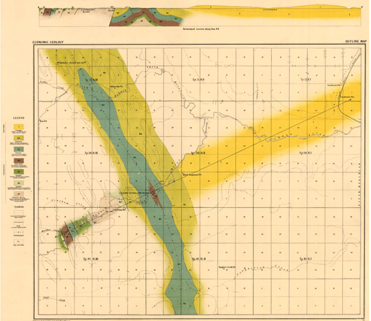
At the time, Dowling speculated that “some of the Upper Carboniferous which is found to be oil-bearing in the Wyoming oil fields, may be oil-bearing in some places beneath this mass of Cretaceous”. But early drilling was focused on the shallower Cretaceous strata, and it wasn’t until years later, when there was more subsurface control and the first seismic surveys were interpreted, that the Carboniferous Turner Valley Formation was recognized as a major oil reservoir in Alberta’s first giant field – Turner Valley (Fig. 2).

Resource Exploration “Golden Age”
Moving into the second half of the twentieth century, Canadians realized they were sitting on treasure troves of resources – and employed more sophisticated geology supported by geophysical technologies to find and develop those resources.
In the oil and gas business, Leduc was discovered in 1947, after a famous series of dry holes and shallow gas wells. But exploration wasn’t happening only in the Plains of Alberta – early wells were drilled in northeastern B.C. and in Saskatchewan as well, in addition to the big discovery at Turner Valley. While early seismic played an important role in the Leduc discovery, prospectors were still mapping surface structure and cataloguing surface seeps and shallow shows as primary exploration tools.
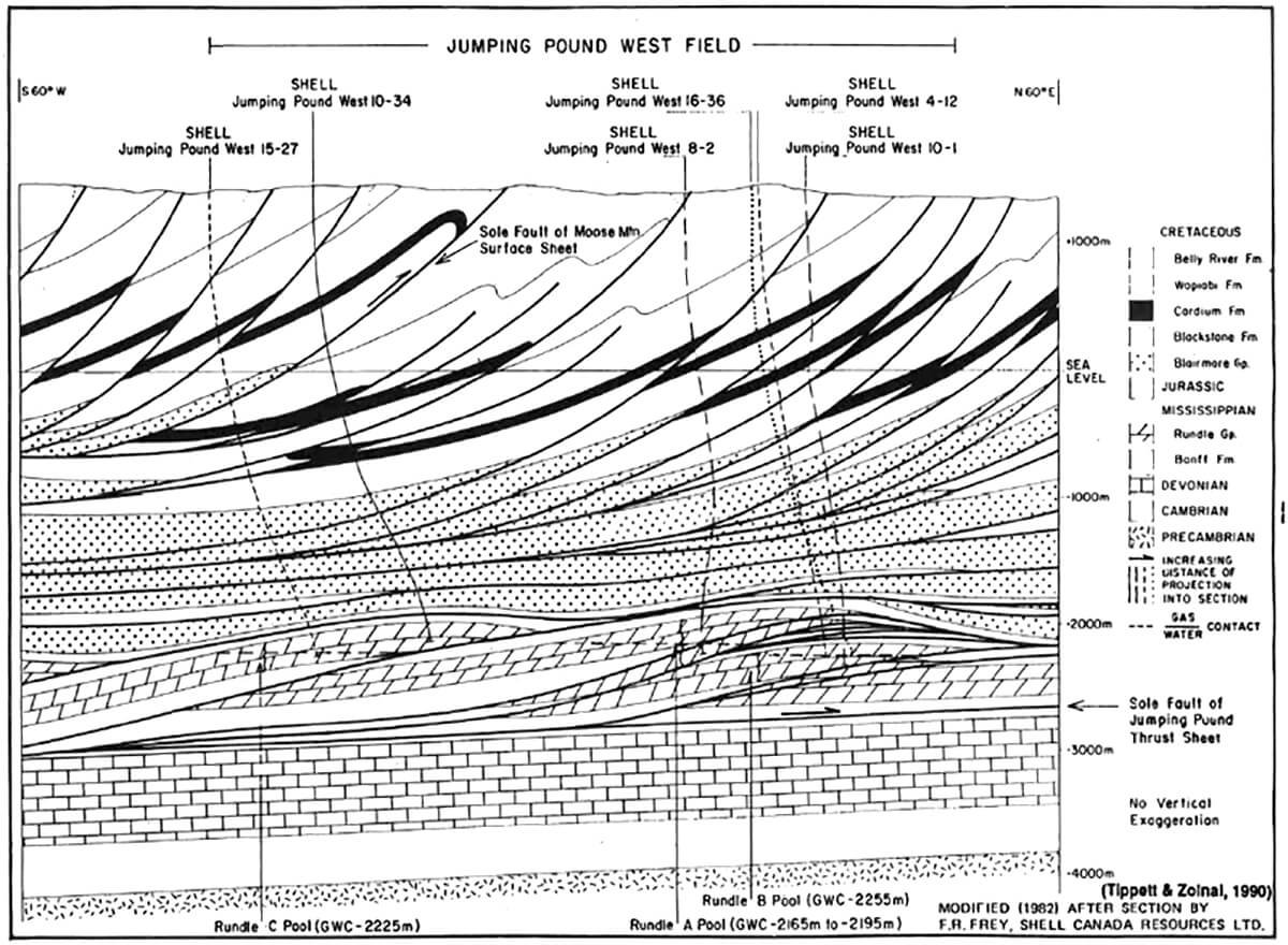
After Leduc, however, explorers became more and more enthused about geophysical technologies that allowed them to image the subsurface and better understand early drilling results. Major new reef reservoirs – Leduc, Swan Hills, Slave Point, Nisku, Rainbow – were discovered almost at regular intervals as seismic technologies were applied and improved. Big gas fields in the Foothills – Jumpingpound, Waterton and others – were found and delineated as our understanding of thin-skinned Foothills deformation came of age in the 1960’s (Fig. 3).
These sophisticated subsurface models – which have been applied in fold and thrust belts around the world– were built with a strong contribution from surface mapping in the Rocky Mountains tied to subsurface control, both in understanding structural styles and in defining reservoir strata and trends.
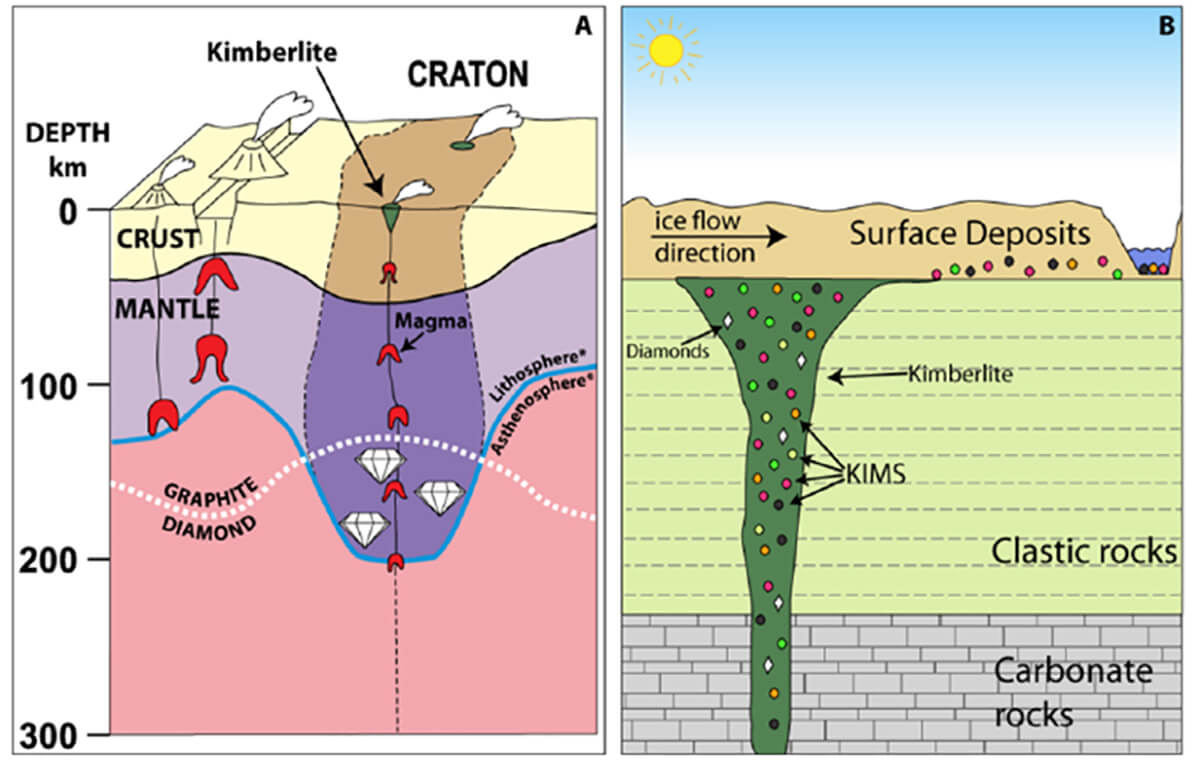
At the same time, sedimentary / stratigraphic models and advanced geoscience techniques supported exploration for and development of other resources – particularly potash and related salts, a major resource industry in south-central Saskatchewan. Exploration programs for diamonds also kicked off in northeastern Alberta, where the sedimentary cover is relatively thin, and geophysical surveys guided by surface prospecting for indicator minerals located a number of prospective kimberlites (Fig. 4).
The Rise of Unconventionals
As the 20th century drew to a close, the sophistication of exploration continued to increase as we conceptualized and then delineated huge unconventional oil and gas resources in the Deep Basin, in shallow coal beds, and in oil sands reservoirs along the Alberta / Saskatchewan border in areas too deep to mine at surface. A variety of subsurface geoscience disciplines – stratigraphy / sedimentology, seismic, petrophysics, hydrogeology – all played important roles. Engineering advances, particularly the perfection of horizontal drilling, hydraulic fracturing, and thermal recovery methods, allowed us to exploit these resources.
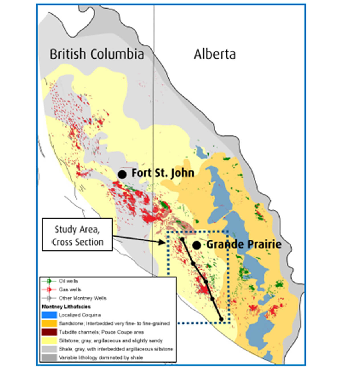
But in the first decade of the 21st century, North American explorers became the victims of their own success – flooding gas and then oil markets with so much product that world prices fell and severely damaged the economic framework of the industry. Companies gobbled up rights to unconventional oil and gas fairways in a series of “land rushes” between the early 2000’s and 2014. Exploration fell out of fashion as the challenge moved from finding resources to delineating and efficiently drilling the “sweet spots” in known resource fairways (Fig. 5).
At the same time, potash markets reached similar saturation levels, while diamond prospecting and mining remained focused in the North, where sedimentary cover is thin or absent. Today, real exploration for the “old” commodities – hydrocarbons and potash – is essentially dead in western Canada – replaced by the systematic development of vast unconventional hydrocarbon accumulations and well-established potash resources. So is there any exploration left to do?
Exploration Alternatives
Well, yes, there is, and it’s happening. Here are some examples:
- Water: unconventional resource extraction uses significant amounts of water, competing against ever-growing demands for agricultural and domestic use. But unlike farms and municipalities, tight oil and gas players can use lower-quality (brackish or saline) water for hydraulic fracturing. Subsurface mapping knowledge and skills can be applied to explore for effective deep water source and disposal zones, which can reduce demand for fresh surface water or shallow groundwater, and also reduce the danger of contaminating freshwater resources.
As well, calcium-rich brines are in demand for road treatments, keeping dust down on gravel roads in the summer and reducing the need for more corrosive sodium-rich salts on city streets in the winter.
Exploring for the right deep water resources is not as easy as one would think – it’s very similar to oil and gas exploration, except you don’t need to worry about the trap. But the risks of poor reservoir or finding the wrong fluid remain – what if you accidentally drilled an oil well? - Lithium: Companies are tying up rights to access deep saline brines in some of our primary petroleum reservoirs in order to extract minerals such as lithium, which is much sought after for use in batteries and other high-tech applications. Again, we need those geoscience skills to pinpoint optimal volumes, compositions, and deliverabilities.
- Helium: Another critical element in modern technologies (super cooling magnets in MRI machines, providing inert atmospheres in electronics manufacturing, and purging rocket fuel tanks are a few examples), helium evolves from radiogenic decay of heavy radioactive elements in basement rocks. Petroleum exploration techniques are perfect for finding and delineating helium, whether it occurs mixed with hydrocarbons or with other inert gases. Focused, systematic helium exploration is now looking more attractive as impending shortages and supply chain problems become clearer.
- Geothermal: Various geothermal techniques require hot permeable rock, hot fractured rock, or simply hot rock to host closed-loop circulation of fluids. Oilfield knowledge, databases and mapping can be essential in exploring for optimal geothermal sites.
- Energy storage: Some of the more esoteric energy storage schemes to support intermittent renewable power generation involve pumping gases or fluids underground, and capturing energy when flowing them back out again. Excavating salt caverns or creating massive fracture networks in relatively shallow bedrock have both been proposed, and both require extensive exploration for the right rocks with the right properties in the right places.
Conclusions
The world will always need natural resources. While many people focus today on reducing the role of hydrocarbons as energy sources for humanity, realistic and thoughtful analysis demonstrates they will be critically important for decades to come. In western Canada, our hydrocarbon resource endowment is so large and well-established that we have shifted from “explore” to “develop” mode. Of course, this is true only in the most developed basins of North America; oil and gas exploration flourishes elsewhere in the world.
But resource exploration, supported by our advanced geoscience capabilities, is alive and well in western Canada. We are re-focusing our expertise on exploration for water, strategic metals, helium, geothermal energy, energy storage – and others I haven’t thought of or heard of yet.
Will “new” exploration leverage the exploration skills we have developed over the past century? Absolutely. Do we need to develop new geoscience skills? Yes. Will “new” exploration employ as many people as were employed in the “golden age” of oil and gas exploration? Likely not. Exploration, like climate, always changes. We need to understand and work with those changes.
Acknowledgements
Thanks to Draga Talinga for asking me to put this article together. I’m very grateful to CSUR (Canadian Society of Unconventional Resources) and CSPG (Canadian Society for Petroleum Geologists) for their long-term support of Outreach programs that inspire thinking about exploration issues. CSEG and these groups form a powerful alliance supporting geosciences in Canada.


Join the Conversation
Interested in starting, or contributing to a conversation about an article or issue of the RECORDER? Join our CSEG LinkedIn Group.
Share This Article