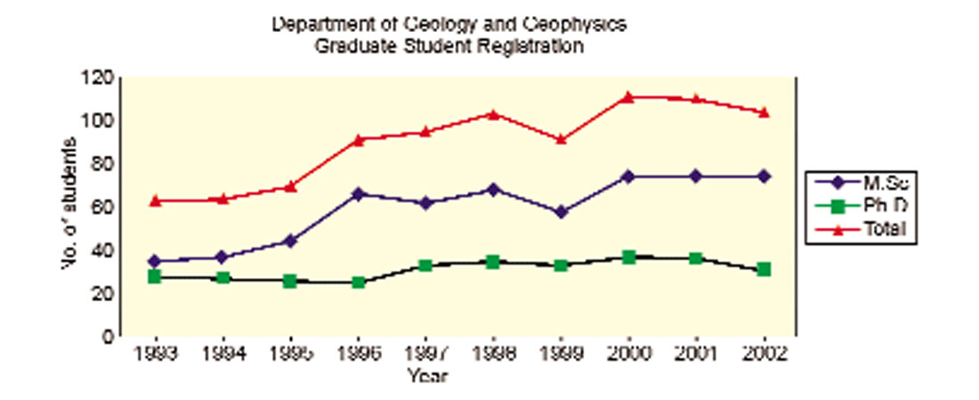
The Department of Geology and Geophysics at the University of Calgary began its geophysical life in 1967, when Dr. Peter Gretener joined the department. A geophysics major was first offered in 1970 and the first Ph.D was awarded to Art Sweet in 1972. The department now has high enrolments at both the undergraduate and graduate level (Figure 1). Currently there are 32 faculty, 11 of whom are geophysicists, and over 50 geophysics graduate students. In 2001, our department awarded 87 B.Sc. degrees, 12 M.Sc.s and 3 Ph.D.s. Many of the faculty and students have received awards for teaching, research, presentations at conferences and contributions to science. Applied Geophysics has developed into a major area of strength over the last decade, with a significant proportion of the research being funded through industrial consortia and the government (to a total of approximately $3.5 M). There are three major geophysical research consortia in the department.
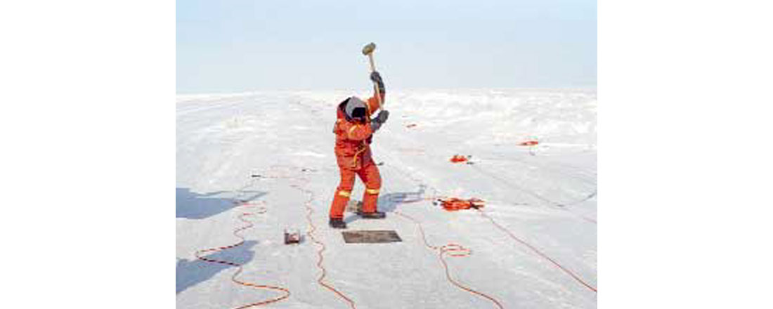
The Consortium for Research in Elastic Wave Exploration Seismology (CREWES) was created in 1989 and conducts advanced geophysical research and education in areas crucial to resource exploration and development. It focuses on multicomponent and 3-D data acquisition, new and improved processing algorithms and interpretation techniques aimed at enhanced 3-D petrophysical imaging. CREWES is directed by Dr. Rob Stewart and currently has 8 professors, 8 staff and 30 graduate students. The acquisition of 3-C surveys plays an important role in the project and field work opportunities contribute to the collective sanity. A recent CREWES survey near Tuktoyaktuk was designed to investigate the acquisition of converted wave data through ice (Figure 2).
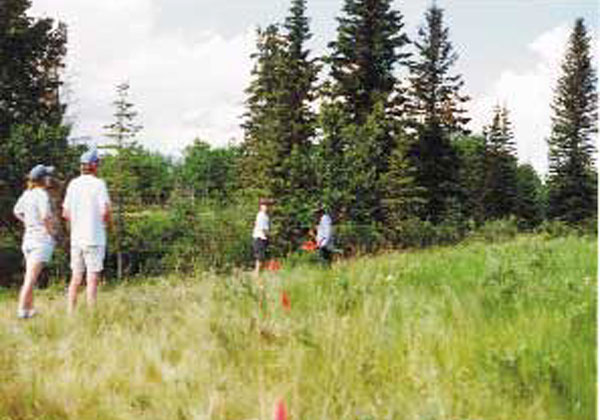
The Fold-Fault Research Project (FRP) involves integrated geophysical and geological research into the 3-D geometry and evolution of structures of economic and academic interest in fold and thrust belts. It started life in 1994 as the Foothills Research Project but changed its name after recent expansions into areas such as South America, New Zealand and the east coast of Canada. The objective of the research is to reduce the risks involved in finding and exploiting oil and gas reservoirs in fold and thrust belts. The Queen’s University branch of the project also undertakes centrifuge modelling studies to study the evolution of fold and thrust belts. FRP has 4 directors, 4 staff and 20 graduate students. Much of FRP’s recent work has addressed the problems of seismic imaging of fold-fault structures and the role anisotropy plays in imaging and mispositioning problems. Field work to gather refraction seismic data (Figure 3) and VSPs have helped FRP to develop ways of estimating the anisotropy parameters. CREWES and FRP also use an acoustic and physical modelling laboratory in which they conduct scaled seismic acquisition experiments.
LITHOPROBE is a national interdisciplinary research program created to answer fundamental questions on the nature and evolution of the lithosphere beneath Canada and its surrounding oceans. The LITHOPROBE Seismic Data Processing Facility (LSPF) at the University of Calgary is the national data archive centre for all deep crustal reflection and refraction seismic data acquired under the program. LITHOPROBE’s principal scientific and operational components are built around a series of ten transects spanning the country from Vancouver Island to Newfoundland (Figure 4) and geological time from four billion years ago to the present. The LSPF is directed in Calgary by Dr Frederick Cook and employs 4 staff.

There are also individuals with research interests that include metallic mineral exploration geophysics, planetary sciences, theoretical and computational seismology, mathematical geophysics, environmental and archaeological geophysics and the dynamics of the earth.
It is not all work though. Among the popular social activities are the annual slide show, the Christmas party, a staff versus graduates softball match and regular Attitude Adjustment gatherings. We end the week with a FATS (Friday Afternoon Talk Series) by an invited speaker, accompanied by awesome homemade cookies.
A physical modelling story by an anonymous FRP staff member.
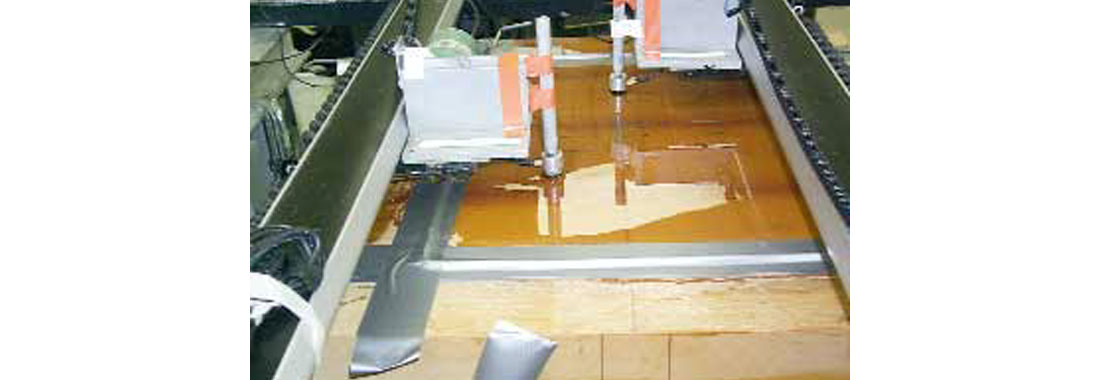
Once upon a time, FRP wanted to acquire a 3-D survey across a physical model constructed to simulate a dipping anisotropic overburden overlying a target. The objective was to study the mispositioning of the target caused by the use of inappropriate isotropic processing velocities. The survey parameters were entered into the computer then the traces recorded one at a time as the single source and receiver transducers traversed the model. Normally the model is coated with a layer of molasses to ensure good coupling between the source and receiver (Figure 5). Since the 3-D survey was taking so long to acquire one trace at a time, the molasses dried up, the transducers adhered to the model and the arms holding the transducers were damaged. These arms were repaired with lovely orange tape. To use water instead of molasses, we built a dam around the outside of the model and poured water over the top of the model (Figure 6). The dam leaked and water started trickling off one side of the model. Eric Gallant trained a heat gun on the leak to dry it while I stood by armed with duct tape to mend the leak the instant the water dried up. Thus we chased leaky spots all around the model. During the acquisition of the survey the water would dry up so Henry Bland fixed up a camera so that I could observe the progress from my office PC via Netscape. When the surface of the model was dry or if the transducers had somehow jumped off the model and were bouncing up and down in space, I would run down to the basement and fix the problem. Sitting at a computer was never this much fun.


Join the Conversation
Interested in starting, or contributing to a conversation about an article or issue of the RECORDER? Join our CSEG LinkedIn Group.
Share This Article