Summary
Advancements in geophysical methods provide opportunities for applications in exploration and development of many types of gemstone deposits. Mega-scale regional techniques, such as teleseismic signals, regional electromagnetic, and long range controlled source seismology (reflection and refraction) soundings, assist in delineating thick cratonic regions and the internal structure of the lithosphere that may be prospective for gems such as diamonds. Meso-scale techniques such as electromagnetics, aeromagnetics, reflection seismology and low frequency (~100 MHz) ground-penetrating radar assist in mapping individual features such as kimberlite pipes, plutons and placer deposits. “Micro”- scale techniques such as high frequency (~1000 MHz) ground-penetrating radar and, possibly, ultra high frequency (MHz) seismology are already allowing identification of gem-bearing cavities and perhaps in the future even individual crystals.
Introduction
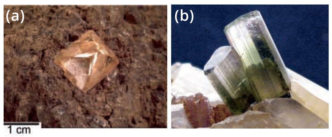
The purpose of this paper is to describe how geophysical techniques can be used in the exploration for gemstone deposits. Some applications are well known; exploration and delineation of diamond-bearing kimberlites (Figure 1a) using both regional and detailed geophysical techniques has been accomplished for decades. Some applications have recently become feasible; ground-penetrating radar has been successfully applied in delineation of gem-bearing cavities (Figure 1b). Some applications are only now being contemplated; delineation of individual crystals using Mega-Hertz seismic signals may be tested in the near future. As gemstones become increasingly difficult to find and to excavate, geophysical tools are playing an increasingly important role in exploration and development of gemstone deposits.
Technological advances are providing new methods that can be used in exploration for many different gemstones at many different scales of observation. Some techniques, such as aeromagnetics, have been used in diamond exploration for decades (Smith and Fountain, 1999). However, as our knowledge of the regional geophysics and large (continent-scale) structures expands on one end of the spectrum, and as our ability to image increasingly detailed resolution (centimeters or less) improves on the other, applications of techniques that aid in delineating prospective regions and structures becomes feasible. Accordingly, geophysical techniques now used in these endeavours include such diverse methods as large-scale regional studies for focusing on prospective areas, intermediate resolution methods for identifying likely rock types that may contain deposits, and finally highly focused and detailed methods for aiding in the identification and delineation of gem-bearing zones. In the following descriptions, therefore, the applications are described according to the scales of geological features that are addressed, from cratons to crystals.
The divisions of scale are somewhat arbitrary, but are based primarily on the resolution of the techniques. For brevity, three are utilized: a megoscopic view from about 10 km to 10000 km, a mesoscopic view from about 10 m to 10 km, and a “microscopic” view from about 1 cm to 10 m. The “microscopic” view is not truly microscopic, of course; however, it represents resolution at scales that were unattainable a few years ago but will be with new technology is either proven or within reach today.
In reviewing the applications of geophysical methods in exploration for gemstone deposits, it is clear that there is great potential that is presently unrealized. Some of the reason for this is historical; many geophysical techniques have been developed for petroleum exploration and have not been focused on gemstone deposits. Some of the reason is technical; gemstone deposits are commonly small, thus requiring resolution that is not commonly available with many geophysical tools. (A single cavity that is less than a cubic meter may contain material worth thousands of dollars or more). Some of the reason is economic; many gemstone deposits are not sufficiently valuable to warrant applications of expensive methods to find them, whereas those with globally recognized value (e. g. , diamonds) have enjoyed substantially more activity.
However, technological advances with existing methods, development of new methods, and applications of various methods in novel ways provide opportunities for discovery and development in the relatively young field of geophysics applied to gemstone exploration. Some opportunities include: 1) evolving ideas concerning the relationships of deposits to large-scale structures and tectonic processes, 2) using geophysical methods to map rocks that may host gem-bearing zones, and 3) applying high resolution methods to direct detection of such zones. Accordingly, some of what is presented here is review of an expanding and rapidly growing field. In addition, however, where possible, comments are made on how some methods may hold promise for future applications in detecting and developing important gem deposits.
The Megascopic View (104 - 107 m): Cratons to Crust
Cratons
The Earth’s major surface features such as oceans, continents, mountains and basins are formed by lithospheric plate interactions. Products of these interactions have characteristic chemical and mineralogical signatures; our ability to relate mineral deposits, including gemstones, to these tectonic products has grown along with our expanding knowledge of global plate tectonics. Geophysics has played a key role throughout this evolution. Thus, to the extent that the formation of some gemstone deposits can be related to these large-scale (tens of kilometers to thousands of kilometers) processes, regional geophysical methods assist in focusing in areas that may be prospective for certain gemstones. Methods such as detecting teleseismic or magnetotelluric signals to map the thickness of the craton are commonly used. In addition, however, measuring refracted seismic waves from the upper mantle to determine the velocity structure has been used in some regions, and deep seismic reflection profiling is now capable of producing information to map the fine structure of the continental crust and, in some cases, even the sub-crustal mantle.
Perhaps the best known example of using regional geophysics to assist in gemstone exploration is employed in exploration for primary diamond deposits on continental cratons (Table 1). The continental lithosphere includes the ~35-45 km thick crust near the surface and ~55 to more than 150 km of relatively rigid mantle beneath the crust, thus amounting to total lithosphere thicknesses of 100 to more than 200 km. The less rigid (probably partially molten) asthenosphere separates the lithosphere from the rest of the mantle below.
| Method | Measured Parameters | Effective Observation Scale (m) | Effective Depth (m) | Effective Resolution (m) | Limitations | Application(s) in Gemstone Exploration |
|---|---|---|---|---|---|---|
| Teleseismic (earthquake) | seismic velocity, amplitude | 104 - 106 | >106 (limited by signal energy) | >103 (depends on signal frequency; spacing) | low resolution; not used for mapping detailed structure | craton thickness in diamond exploration |
| Magnetotellurics | electrical conductivity | 104 - 106 | 104 - 106 (limited by surface conditions, signal energy) | 103 (depends on signal frequency; spacing) | inherent ambiguity between rock conductivity and geometry | craton thickness, mapping kimberlites, metal deposits |
| Seismic Refraction | seismic velocity, amplitude | 104 - 106 | 103 - 105 (limited by surface conditions, signal energy) | 103 (depends on signal frequency; spacing) | not generally useful for detailed structure | mantle velocity in diamond exploration, depth to basement |
| Seismic Reflection | seismic velocity, amplitude, geological structure | 103 - 105 | 101 - 105 (limited by surface conditions, signal energy) | <101 -102 (depends on signal frequency; spacing) | relatively expensive; not easy to image <50 m depth | reconnaissance and detailed geologic structure, mapping subsurface kimberlites |
| Gravity | variations in mass | 102 - 104 | 102 - 105 | 102 (depends on station spacing) | inherent ambiguity between rock density and geometry | reconnaissance geological structure, density variations |
| Magnetics | variations in magnetic susceptibility | 102 - 104 | 102 - 105 (limited by depth of Curie temperature, ~550°C) | 102 - 105 (depends on measurement spacing) | inherent ambiguity between rock magnetism and geometry | reconnaissance geological structure, mapping kimberlites |
| Ground Penetrating Radar | variations in dielectric constant | 10-2 - 102 | 10-1 - 102 (limited by highly conductive layers) | 10-1 - 102 (depends on signal frequency) | signal penetration only to ~50-100 m; data may be adversely affected by near surface | identifying cavities, mapping detailed sediment features |
Primary (uneroded) deposits of diamonds occur only within ancient continental cratons (Janse, 1994). The reason for this is that the mineralogical phase change of carbon from graphite to diamond requires relatively low temperatures at high pressures (depressed thermal gradient) which occurs within the old, cold stable cratons of the Earth (Haggerty, 1986). The most prospective regions for primary diamond deposits are therefore those areas of lithosphere that have the greatest thicknesses (the oldest, coldest and most stable; Figure 2). Hence, methods that provide information on mapping thicknesses and lateral extents of cratons are being used to limit explored regions.
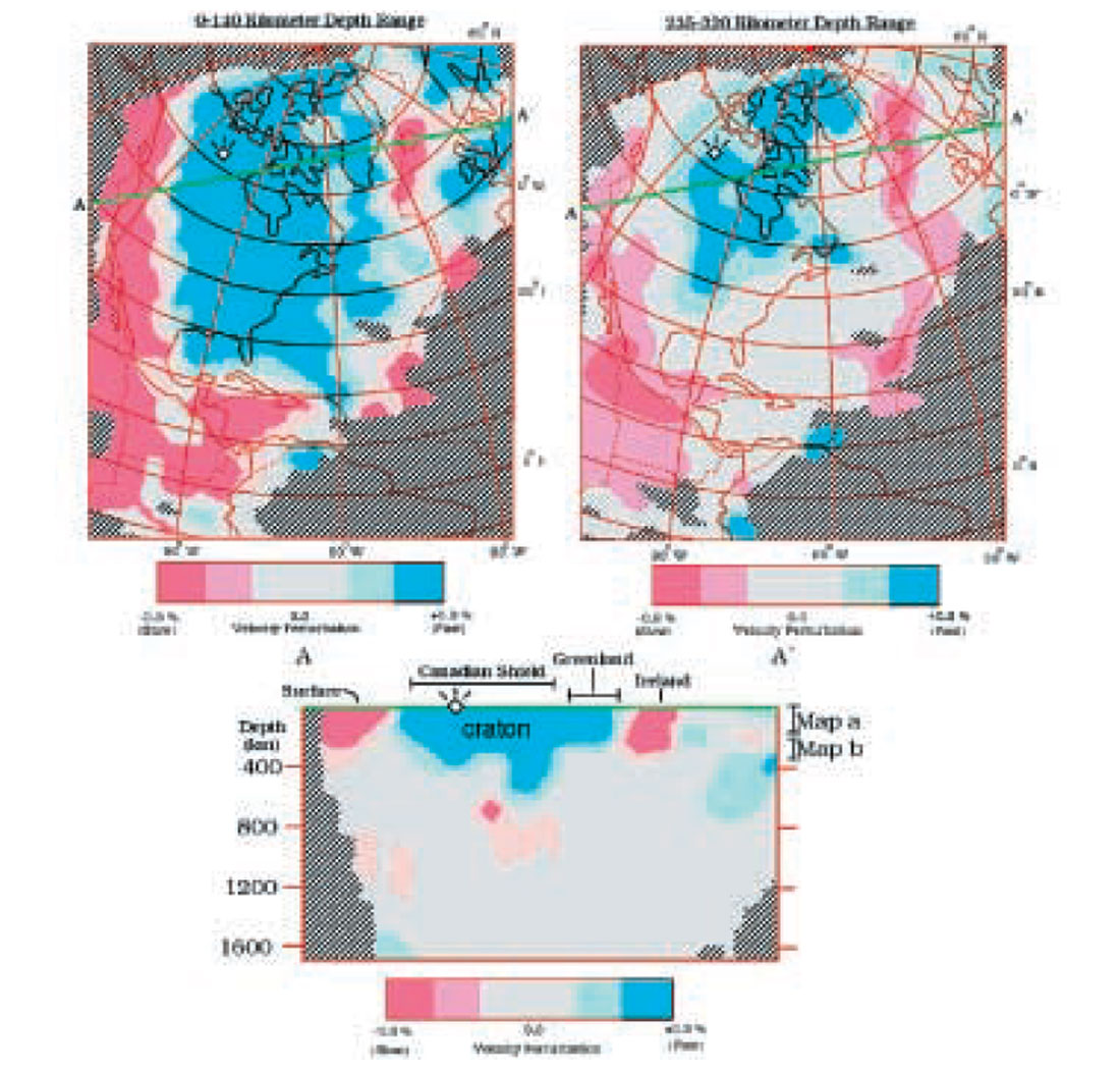
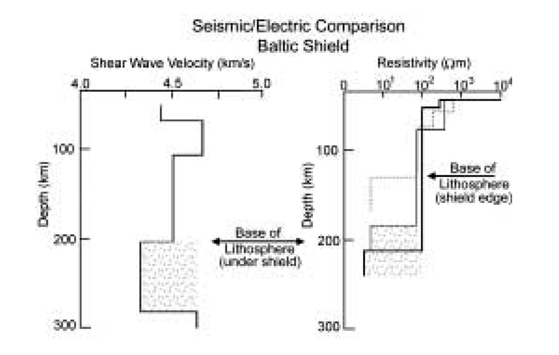
The base of the continental lithosphere may correspond to changes in physical properties of mantle rocks, including seismic velocity (decreasing by about 10% from the lower lithosphere to the partially molten asthenosphere; Figure 3) and electrical conductivity (substantially higher in the asthenosphere). As a result, techniques that allow signal penetration to more than 100-km depth and that respond to these properties have been used to map the lithospheric thickness. Two such geophysical methods are earthquake seismology and magnetotellurics.
Within Canada, measurements of earthquake waves that are transmitted through the continental craton have been accomplished in northern Saskatchewan (Bank et al. , 1998), the Western Superior region of Ontario (Kay et al. , 1999; Sol et al. , 2002) and in the Slave structural province in the Northwest Territories (Bostock and Cassidy, 1997). Primary objectives of these studies are to map major changes in seismic velocity structure within and near the base of the lithosphere (>100 km depth). One of the key results utilized for diamond exploration purposes is mapping the base of the lithosphere (see also Grand, 1987; Figure 2a) as well as the internal velocity structure of the lithosphere (e. g. , James et al. , 2001; Figure 2b)
Details of the electrical structure of the Earth are discernible from variations in the earth’s magnetic field caused by atmospheric disturbances (magnetotellurics). With sufficiently large energy for long periods, electrical conductivity structure can be mapped to hundreds of kilometers depth. As the base of the lithosphere may correspond to a transition from relatively low conductivity (high resistivity) solid upper mantle rocks to more conductive (less resistive), partially molten upper mantle rocks, this technique is well suited to mapping this boundary (Jones, 1999; Jones et al. , 2001; Figure 3).
In addition to mapping the depth of the continental lithosphere beneath cratons, however, seismic refraction methods that establish the seismic velocities of rocks within the lithosphere in the upper mantle have also been used. The concept here is that seismic velocity varies somewhat with temperature in the upper mantle (e. g. , ultramafic) rocks. Sub-solidus temperature variations of 10% can inversely affect the velocity by a similar percentage. Thus a peridotite that might normally have a P-wave velocity of 8.0 k/s at 40-km depth and 600° C could have a velocity of 7. 8 km/s at 800° C (Kern, 1978; Black and Braile, 1982). Accordingly, the seismic velocity may be used as a proxy for temperatures; thus, seeking higher velocity upper mantle of cratons has been employed as a means to identify regions that may have low temperatures and thus may be prospective for diamonds.
Although these techniques provide key information on large-scale structures and physical properties of the mantle, they do not generally have sufficient resolution to generate responses that are detailed enough to map internal structures of the lithosphere at scales of hundreds of meters. The method most commonly used to do this in petroleum exploration, seismic reflection profiling, has been applied to studies of the continental crust with much success for more than 25 years. However, reflections from the upper mantle are sparse in comparison to those from the crust (Figure 4).

Nevertheless, in a few places, images of structures from within the mantle lithosphere have been observed with greater continuity and correlatability and thus greater detail than had previously been observed (e.g. , McGeary and Warner, 1985; Cook et al. , 1999; Figure 4). In northern Canada, seismic reflection data provide some of the most detailed images of the sub-crustal mantle anywhere and are also located in a region that has been the focus of exploration and discovery of major diamond deposits in the last decade (Kjarsgaard and Levinson, submitted). At the present time it is not known if any of the structures that are imaged on these data are directly related to the diamondiferous rocks near Yellowknife, NWT. Nevertheless, such data offer the possibility that the internal structure of the diamond-bearing mantle lithosphere here or elsewhere may be imaged with sufficient detail to map diamond-bearing regions.
Crust
In the theory of Plate Tectonics, continental lithosphere grows as a result of accretion of arcs, continental fragments and even other continents. The processes by which the approach and eventual accretion of these materials take place include subduction, where one plate dives beneath another to depths of at least 600 km, related uplift and volcanism, and ultimately the juxtaposition of formerly separated arcs and continents. All of these processes have profound effects on the structure, magmatic activity and ultimately the mineralogy that are key to the formation of gemstone deposits. For example, some jade (jadeite) deposits are formed within a subduction zone due to rapid burial and in regions of depressed isotherms. Another form of jade (nephrite - fibrous actinolite) is commonly formed by regional metamorphism of mafic or ultramafic rocks that occur near ancient collision boundaries (sutures; Leaming, 1978).
Conversely, granitic rocks that are prospective for gem deposits associated with pegmatite dykes are commonly highly fractionated and evolved granites that have been either derived from, or contaminated by, ancient basement rocks. Granitic rocks that are more typical of island arcs tend to be less evolved and thus do not have high concentrations of unusual elements (e. g. , beryllium, boron, lithium, fluorine, etc. ) that are the ingredients of pegmatite-hosted gemstones.
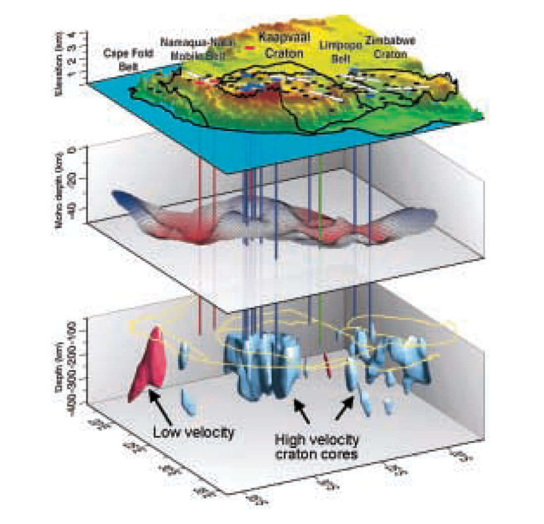
Regional geophysical studies can address the structural architecture and tectonic development of accretionary regions as in the Cordillera of western Canada. Granite plutons in the eastern part of the Cordillera, such as in the Purcell anticlinorium of southeastern British Columbia, often have associated pegmatite dykes that, in a few areas, contain gem beryl, tourmaline and topaz (Reesor, 1973; Wilson, 1999). Many of these plutons are characterized by distinctive low gravity values (Cook et al. , 1995).
In the Coast belt of western part of the Cordillera, on the other hand, the rocks generally have more oceanic characteristics, including island arc volcanics and sediments, ocean floor basalts, and plutons that are less fractionated (more primitive) than those in the east. Accordingly, although there are numerous granitic plutons with pegmatite dykes in this region, the chemical components that are required for the formation of gem-bearing pegmatites are considerably less common. On the other hand, the region has more mafic and ultramafic rock that lead to other kinds of gems such as jade. Some of these mafic rocks correlate with regional gravity and magnetic highs (Cook et al. , 1995). Accordingly, although the potential field data may be helpful in delineating these features, regional seismic studies have not yet been used extensively in exploration for regions of the crust that may be favourable for gemstone deposits. As details of the internal architecture of the continents are elucidated from projects such as Lithoprobe (Clowes et al. , 1998), it is likely that they will be.
The Mesoscopic View (101 - 104 m): Pipes, Plutons, Placers
Pipes
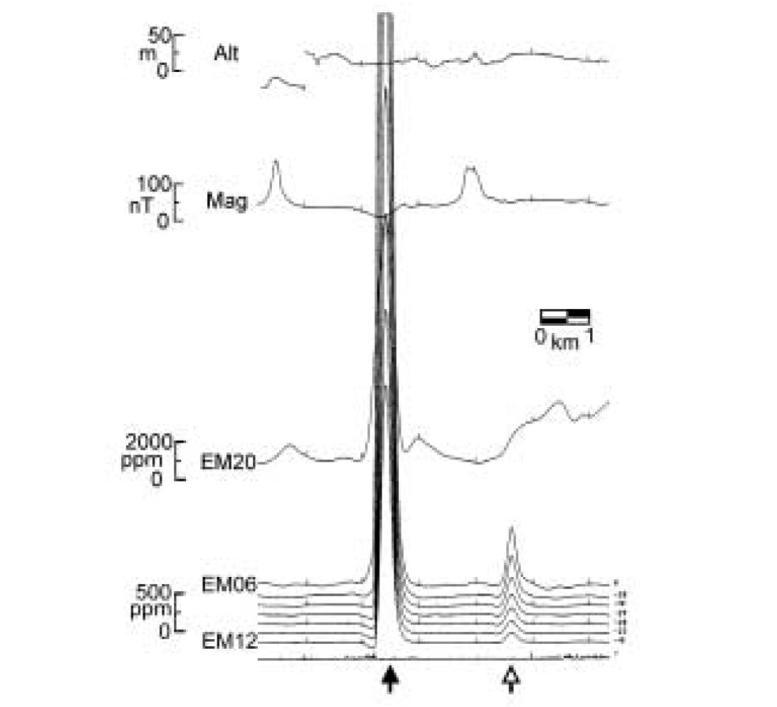
At scales of tens of meters to tens of kilometers, geophysical methods have played a large role in exploration and development of some gem deposits, with well-established studies in searches for diamonds and delineation of the subsurface geometry of some kimberlite pipes. Kimberlites are ultramafic rocks that usually have high density, high magnetic susceptibility (Figure 5a), and high electrical conductivity (Figure 5b) relative to surrounding rocks (e. g. , Smith et al, 1996). As a result, even though they can be relatively small (typically ~ 1 hectare), the contrasts in physical properties can be sufficiently large that they are readily visible (Smith et al. , 1996; Figure 5b).
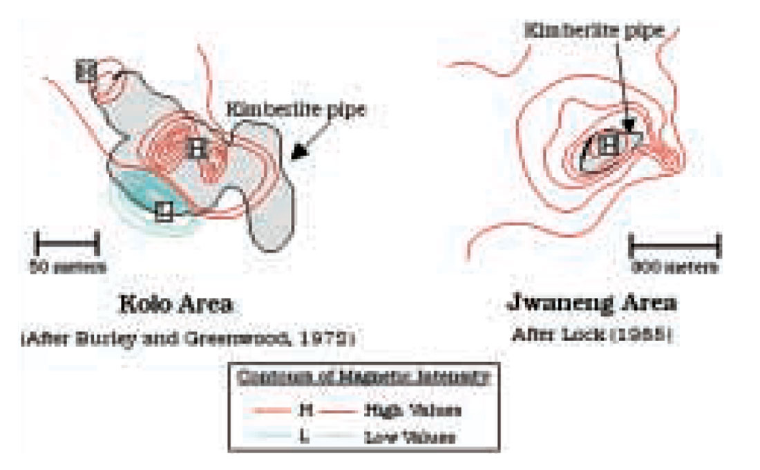
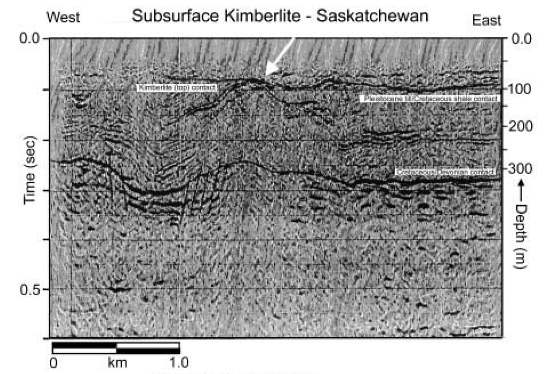
In addition, intrusion of kimberlite magmas is often a violent occurrence that disrupts surrounding sediments. Such disruption, along with the kimberlite pipes and dikes, are sometimes visible on seismic reflection profiles (Figure 6; Gendzwill and Matieshin, 1996; Hammer and Clowes, 2002).
Plutons
The potential exists for greater usage of geophysics in gemstone exploration at these intermediate scales. Consider, for example, the delineation of granite plutons. As noted previously, the tectonic positions of plutons is significant to their chemical makeup and thus to the potential (or not) for economic gem deposits such as occur in pegmatite dykes. Once the interest in a region is established, application of standard geophysical methods such as gravity and magnetics can assist in identifying plutons. Other methods, including geochemistry, will be necessary to choose likely candidates for further exploration.
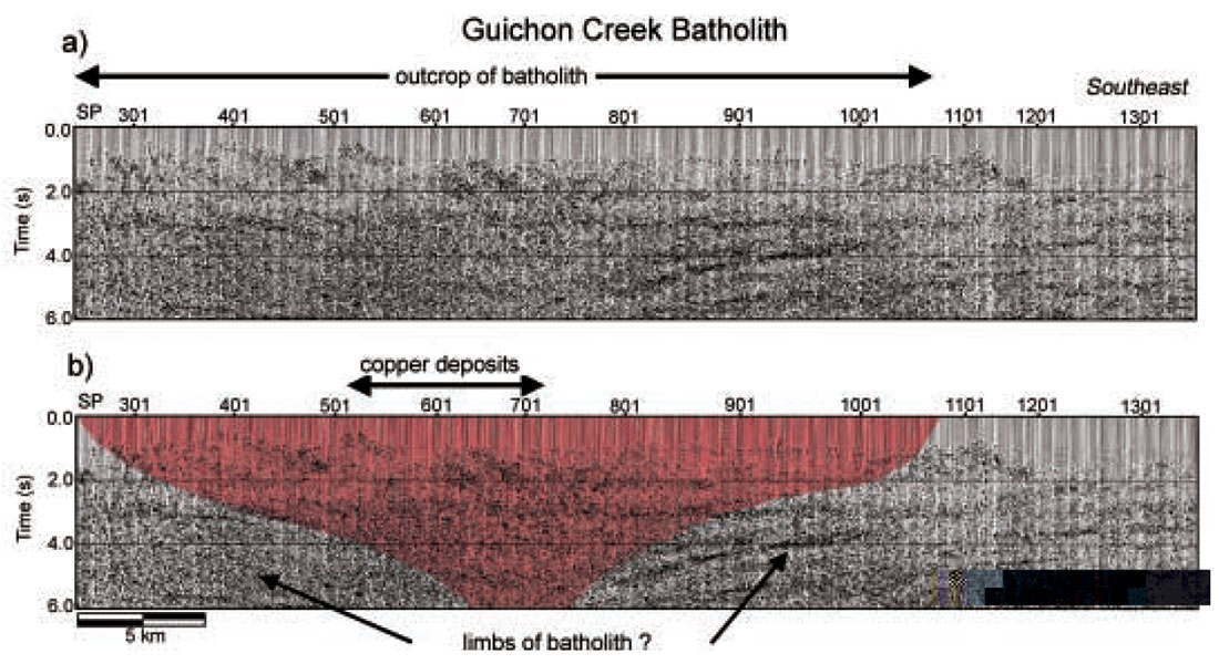
Regional crustal seismic reflection profiles of mountain belts such as the Canadian Cordillera have rarely been successful in producing images of plutons. This may be because the acoustic impedance contrasts between granitic plutons and surrounding rocks are insufficient to produce reflections. In some areas it may also be because the data are initially processed in ways that do not optimize the geometry of plutons. Recently Roy and Clowes (2000) have reprocessed Lithoprobe data that were originally acquired in 1988 in south central British Columbia across the middle Jurassic Guichon Creek batholith that hosts a large porphyry copper deposit at Highland Valley, British Columbia. The effort has produced an image of the subsurface structure of the pluton (Figure 7) and thus offers the possibility that the geometry of other plutons may be delineated with this method. As is common with the complex geologic structure and velocity variations of salt structures, careful and detailed reprocessing is necessary to optimize these results.
Placers
Application of geophysical tools to map placer deposits is a natural outgrowth of methods that are used to map near surface stratigraphy. This includes high-resolution seismic reflection (Buker et al, 1999) and ground penetrating radar (Smith and Jol, 1992). Many of the most economic deposits occur where gems are concentrated in alluvial rocks. These include diamonds (Levinson et al. , 1992), corundum (sapphire and ruby- Surface Search, 2000), and jade, among others. In this application, therefore, it is necessary that the methods have sufficiently high resolution at shallow depths that detailed stratigraphy (layer thicknesses of meters or less) can be mapped over relatively large areas (hundreds of meters square).
The “Microscopic” View (10-2 – 101 m) — Cracks, Cavities, Crystals
Cracks
At scales of centimeters to tens of meters, geophysics has, until recently, not generally played a major role in exploration for, and development of, gemstone deposits. Yet, even once a deposit has been located, the small sizes of the gems and of the gem-bearing zones often provide serious challenges to efficient extraction. Most geophysical tools simply do not have the resolution required to pinpoint gem-bearing zones. Two technological developments in the past few years have begun to alter this situation – ground penetrating radar and ultra-high frequency seismology.
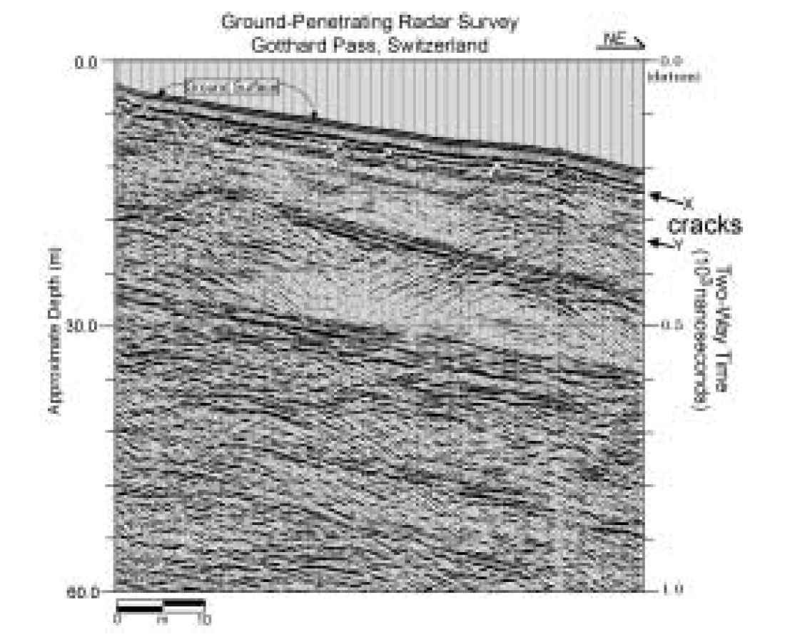
When ground-penetrating radar is applied in crystalline rock (as opposed to near-surface sediments as described above), the signals respond strongly to cracks and cavities. An initial application of radar in exploration for crystallized minerals in veins was unsuccessful (Lees, 1998). However, Grasmueck (1996) and Cook and Vasudevan (1996) have applied this technique in gneissic rocks of the Gotthard pass region in Switzerland where signals were reflected from cracks to as much as 50 m depth (Figure 8). Although these cracks did not contain any crystals, the ability to image them is encouraging for using this tool in exploration for gem-bearing veins and cracks.
Cavities
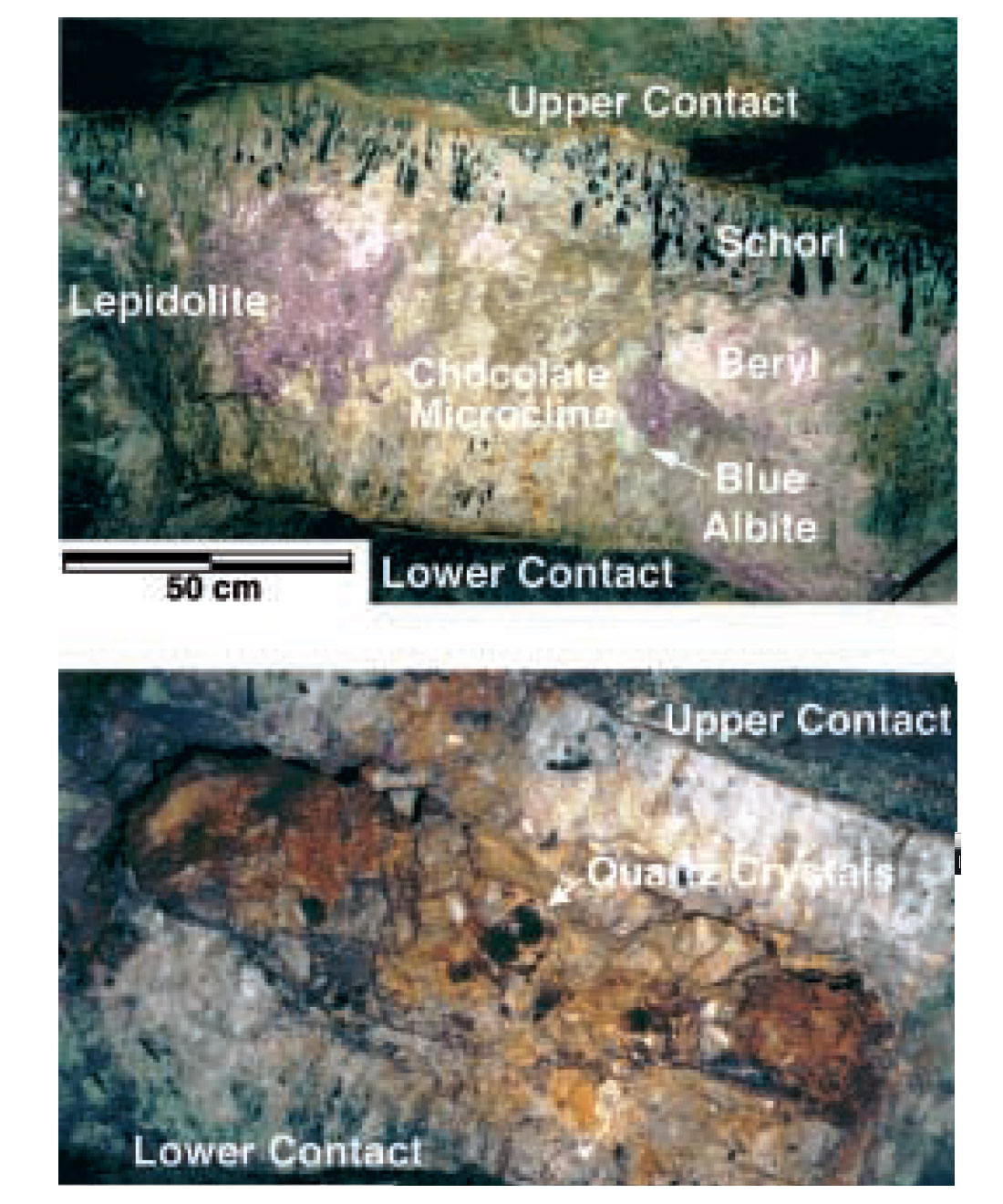
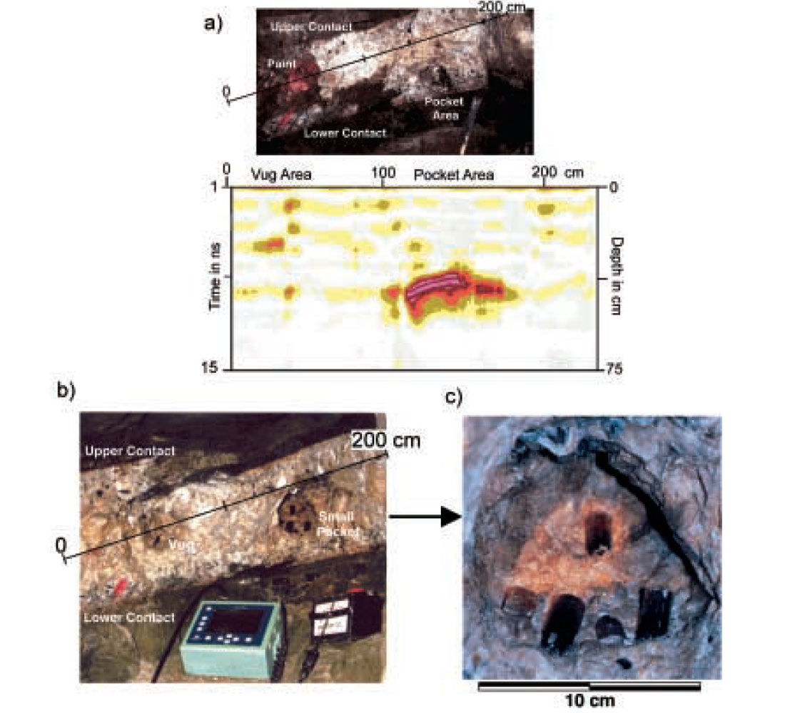
One of the first successful applications of ground penetrating radar in gemstone exploration was accomplished in granitic pegmatites of southern California (Patterson and Cook, 2000; 2002). Here, a series of ~1m thick pegmatite dikes extends for up to 2 km underground (Figure 9) and has produced gem tourmaline (Figure 1b) from cavities (“pockets”) in the dike for more than 100 years. Although the mine was originally discovered based on surface outcrop, mining operations have been entirely underground for most of the last century. Accordingly, if geophysical tools are to be effective in finding gem-bearing zones, it is necessary to be able to identify cavities in the dike; resolution of a few tens of cm is necessary. Following several tests, efforts were successful in locating a gem-bearing pocket in a part of the mine that had been worked nearly a decade earlier and several gem tourmalines were recovered (Figure 10; Patterson and Cook, 2002). Following the initial discovery, more than 25 additional cavities were found and excavated over a seven week period (Patterson and Cook, 2002).
Crystals
Application of ground-penetrating radar (GigaHertz frequencies; Patterson and Cook, 2002) and development of ultra-high resolution seismic (MegaHertz frequencies; Hall et al, 2001) methods in geophysical exploration offers the possibility that in the future smaller cracks, cavities and even crystals may be imaged. According to Patterson and Cook (2002), a radar pulse with a frequency of 1 GHz that has a wavelength of about 10 cm may be able to resolve features as small as 2. 5 cm in size 1 m distance in a rock. Their experiment was successful in identifying cavities smaller than 10 cm.
Ultra-high frequency (~1 MHz) seismology may also become a tool for resolving cm-scale features in gemstone deposits. In a recent model experiment, for example, Hall et al (2001) have measured ultra-high frequency seismic reflections through several cm of material that has a seismic P-wave velocity of ~1900 m/s. The signal had a central seismic frequency of ~0. 33 MHz, a wavelength of ~5-6 mm, and thus a potential resolution of ~1-2 mm (Hall et al. 2001). Whether this technique can realistically be applied to granitic rocks for providing images of features as small as individual crystals in the field is not presently known because it has yet to be tested.
Discussion
Gemstone deposits form in a wide variety of sizes, shapes, and geological conditions. Some are in hard rock such as kimberlites, granite plutons, and metamorphic rocks, while others are concentrated in alluvial sedimentary strata. Some are large deposits encompassing many hundreds of meters or even kilometers in size (e. g. , jade; Leaming, 1978), while others are in decimeter size cavities (e. g. , pegmatite deposits).
Geophysical methods offer possibilities for maximizing discoveries and development at many different scales. Many of the techniques that are now available have tried and true applications in other facets of earth science. For example, teleseismic waves provide key information on earthquakes and the deep internal structure of the earth. Seismic reflection profiling, refraction studies and electromagnetics provide essential information on the internal structure of the lithosphere and crust, including mapping hydrocarbon-bearing zones. High-resolution seismic reflection profiling and ground-penetrating radar are used to map the near-surface environment of the earth.
All of these methods, and more, are appropriate for applications in the search for gem deposits.
Further development in nearly all of the methods discussed here will undoubtedly lead to new concepts about how different gem deposits form and what measurable physical characteristics are most commonly associated with them. Examples of large-scale anomalies that are not yet well understood include the discovery of high electrical conductivity within the lithosphere beneath diamond-bearing kimberlites in northern Canada (Jones et al. , 2001) and the discovery of numerous seismic reflectors within and adjacent to the lithosphere of the diamond-bearing Archean Slave craton in northern Canada (Cook et al. , 1999). How (or whether) these features are related to the adjacent gem deposits is yet to be fully understood.
Examples of developments that promise to enhance the detailed images of gem-bearing strata, cracks and cavities include ground-penetrating radar and ultra-high frequency seismology. Perhaps within a few years it will not only be possible to find a region that looks promising, but also to produce images of gem-bearing zones within a rock before the expense and uncertainty of extraction and production are undertaken.
Conclusions
Applications of geophysical exploration techniques to the discovery and development of gemstone deposits encompass scales from thousands of kilometers to fractions of a meter. Some applications are well established and in common usage; others are just now being tested or are in the initial stages of practical application. Technological developments are producing increased resolution throughout the range of scales and in a variety of rock types. As our knowledge of the geological controls of gemstone formation and deposits grows, the ever expanding geophysical toolkit available to earth scientists will play an increasingly important role in the exploration, discovery and development of many gemstone deposits.

Acknowledgements
This research is supported by the Natural Sciences and Engineering Research Council. Jeffrey Patterson has provided much assistance and knowledge of pegmatite-hosted gems and ground-penetrating radar. Dr. Kris Vasudevan has assisted with many aspects of data processing of ground-penetrating radar and seismic data. Bob Scarborough, Jim Means, Jeff Krogstad, and Mike Menzies provided much field assistance in acquiring the data presented in Figure 10. We are always grateful for the many mine owners who have allowed us to carry out research in their mines: Louis B. Spaulding Jr. , J. Blue Shepard, Ed Swoboda, Bill Larson, and Jim Means.


Join the Conversation
Interested in starting, or contributing to a conversation about an article or issue of the RECORDER? Join our CSEG LinkedIn Group.
Share This Article