Exploration initiatives over the past decade have led to renewed interest in exploration in the slope and deep-water regions of offshore Newfoundland and Labrador, Canada. New multi-client regional 2D seismic surveys (2011-2018), guided initially by satellite slick mapping, have provided approximately 170,000 line kms of long offset, broadband 2D seismic data, and over 22,000 km2 of long offset, broadband 3D seismic data. The data was acquired in areas where possible hydrocarbon seepage and new exploration leads suggested that a working petroleum system existed in these under-explored frontier basins. Prior to 2011, the majority of offshore Newfoundland and Labrador sedimentary basins were defined on limited vintage seismic data, and in some cases gravity data where no seismic data coverage existed. With the initiation of modern regional 2D and 3D seismic programs, Nalcor Energy commenced the systematical mapping of the Newfoundland and Labrador offshore in order to assess the extent of the sedimentary basins and also to develop an understanding of the hydrocarbon potential in these frontier regions. In conjunction with seismic data acquisition, Nalcor Energy has initiated a number of scientific studies to build on this new knowledge base and help de-risk exploration in these areas. These regional studies include metocean, regional drilling metrics, biostratigraphy, seabed coring, CSEM, source rock geochemistry, fluid inclusion, geopressure, rock physics, high resolution digital capture and cataloguing of cuttings, core and thin section data, and resource assessment studies. These studies aim to assist in providing foundational insight to the region’s exploration potential and operational and subsea considerations. This integrated approach to regional exploration data collection will act as a template for future work in other Newfoundland and Labrador offshore areas.
Introduction
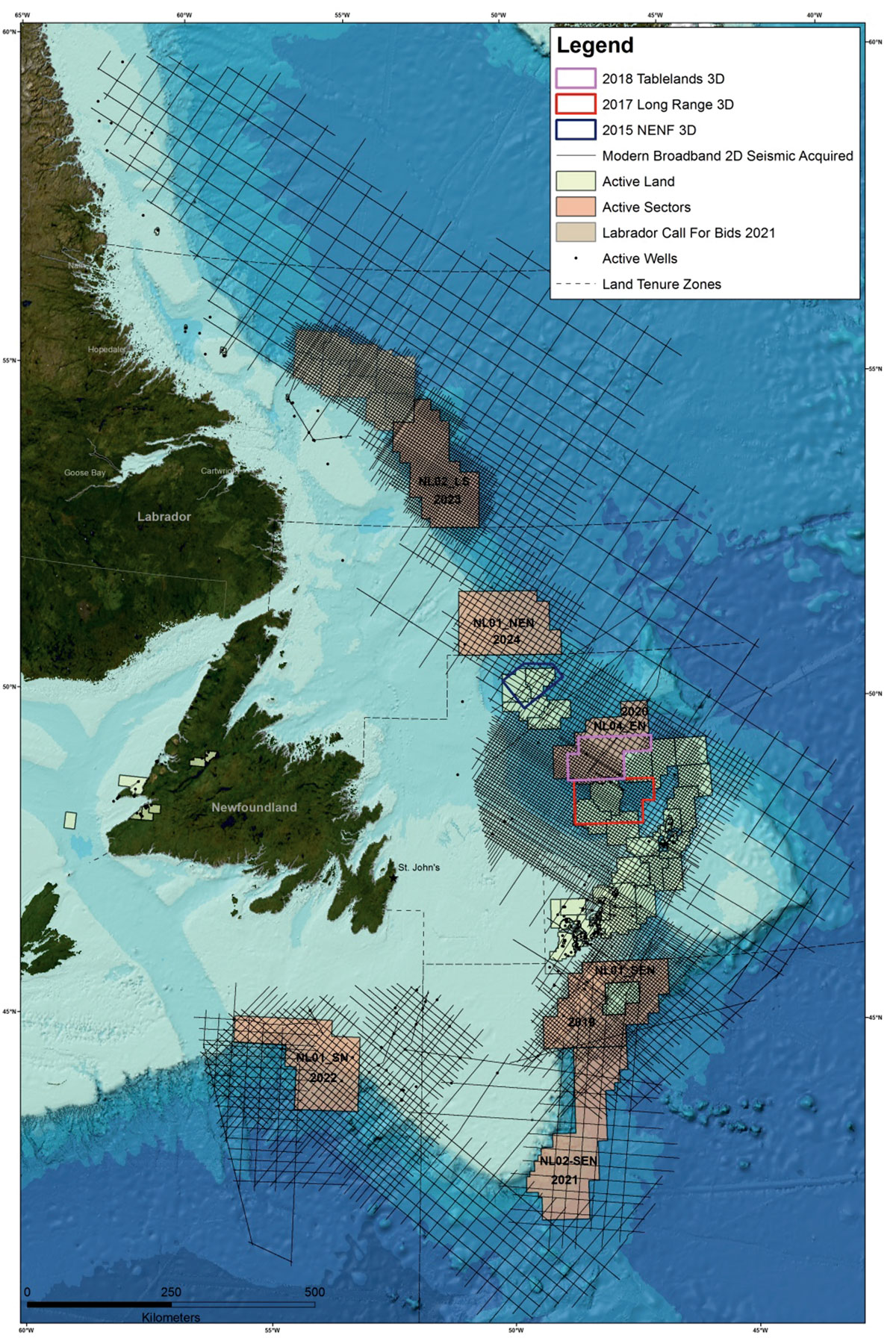
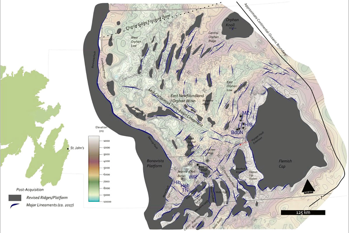
Covering an area of approximately 1 million km2, Newfoundland and Labrador’s sedimentary basins remain largely under-explored. Dormant exploration activity led to a 30 year gap in data collection over most offshore regions. In 2009, Nalcor Energy and Airbus (formally Astrium) engaged in a satellite survey of the Labrador Sea to map surficial, naturally occurring hydrocarbon slicks throughout the eastern margin of Newfoundland and Labrador. Results from that work led directly to a proposed Nalcor-invested-and-partnered TGS-PGS multi-client 2D regional seismic survey in the deep-water areas of the Labrador Sea and south into the Orphan and Flemish Basins (Figure 1). Seismic data collection continued year over year; these new regional long-offset seismic surveys now comprise over 170,000 line kms of high quality 2D seismic data and three 3D seismic surveys, covering approximately 22,000 km2. Early interpretational results of some of that data have led to revisions of the regional basin configuration in the Orphan/Flemish Basins (Cameron et al, 2017, McCallum et al, 2017, Figure 2). As well, new seismic data and interpretation have defined new Mesozoic and Cenozoic basins in the slope and deep water (Carter et al, 2013), and have extended the limits of the known Mesozoic- and Cenozoic-aged basins.
Initiatives
Through the acquisition seasons of 2011 to 2018, new long-offset 2D and 3D broadband Geostreamer seismic data were acquired covering the offshore Newfoundland and Labrador slope and deep-water regions (Figure 1). A significant percentage of the survey is in an area of the Labrador Sea deep water that was never before imaged by seismic data. With newly acquired 2D seismic data, in 2012-2013 the exploration group was able to define three new sedimentary basins (Chidley, Holton, and Henley basins) and refine the mapping on a fourth basin (Hawke Basin) (Carter et al, 2013).
Seismic data acquisition will continue in 2019, expanding the regional coverage of the southern regions of the Newfoundland offshore, as well as the 3D seismic coverage. Insights from the seismic data have led to a number of studies, including continued satellite seep assessment, seabed coring, metocean, regional geopressure, regional rock physics, acquisition of CSEM data, and continued gravity acquisition to help with potential basement definition The data taken from these various studies are then used as inputs into an independent basin analysis study by Beicip-Franlab in the form of Resource Assessments over upcoming license round areas.
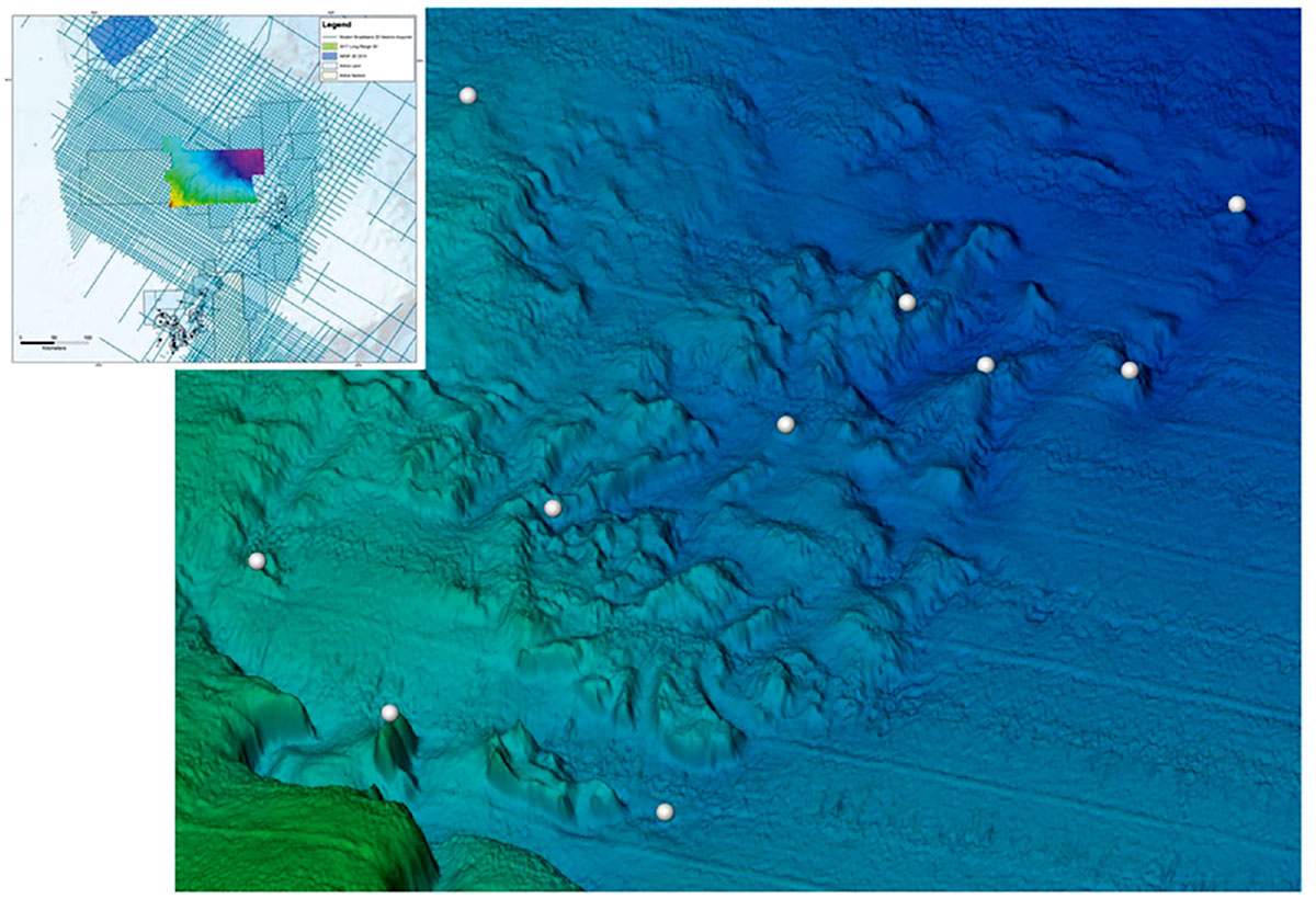
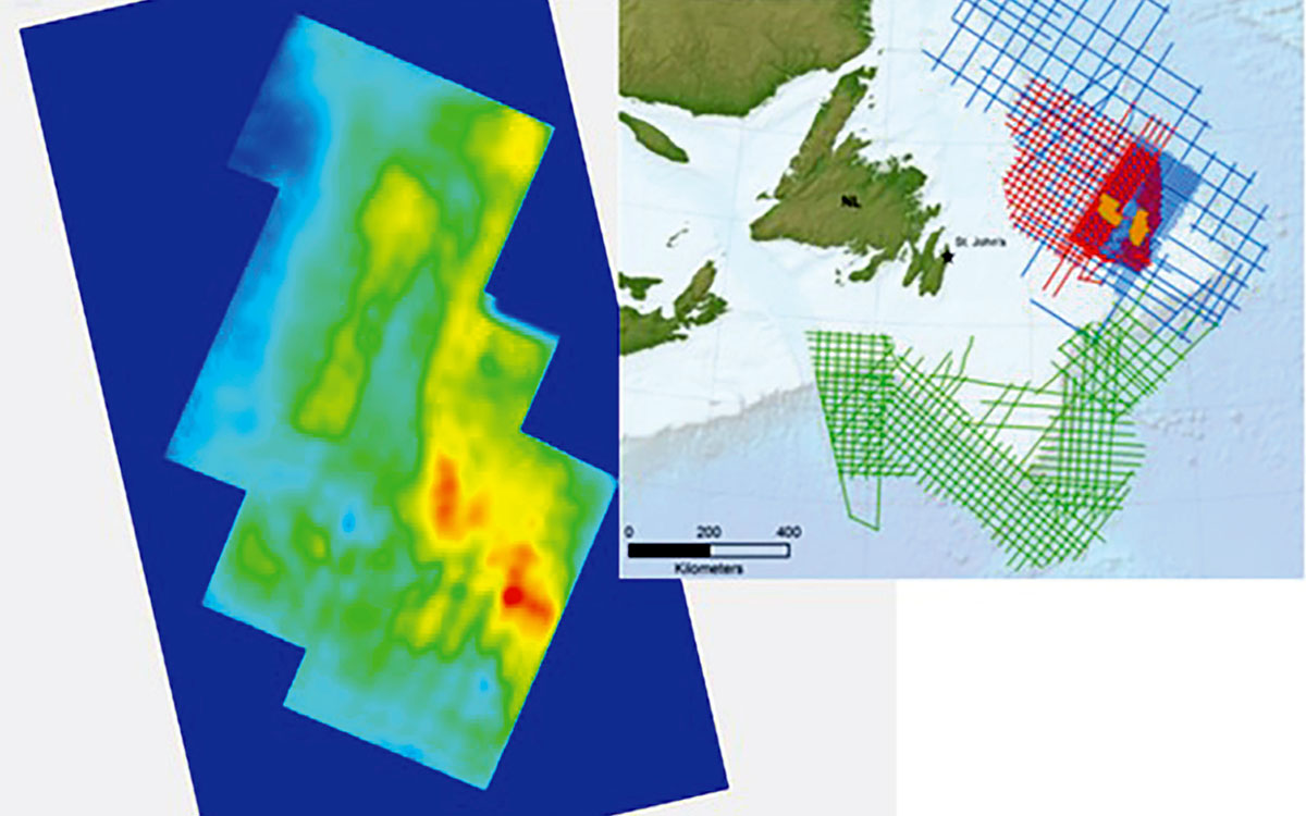
In 2017 Nalcor Energy – Oil & Gas partnered with Fugro Inc., to conduct a 10,000 km2 multibeam, heatflow, and shallow seabed coring project over the 2018 Newfoundland and Labrador Call for Bids area within the Orphan Basin. The first phase of the survey was designed to acquire multibeam and backscatter images from the seafloor and to look for indications of hydrocarbon seep escape features or water column anomalies. The second phase of the survey included the recovery of 99 shallow seabed cores for geochemical analysis of headspace gas, isotopes, and biomarkers. As well, 12 heatflow locations were acquired, where multiple heatflow measurements were taken for redundancy. Encouraging results of the 2017 Orphan seabed sampling study led to the acquisition of the 2018 multibeam, heatflow, and seabed coring study conducted over the 2019 Carson/Bonnition/Salar license round area. This survey is showing positive results in the preliminary data, with water column anomalies, as well as above-background thermogenic indications in the onboard headspace gas analysis (Figure 3).
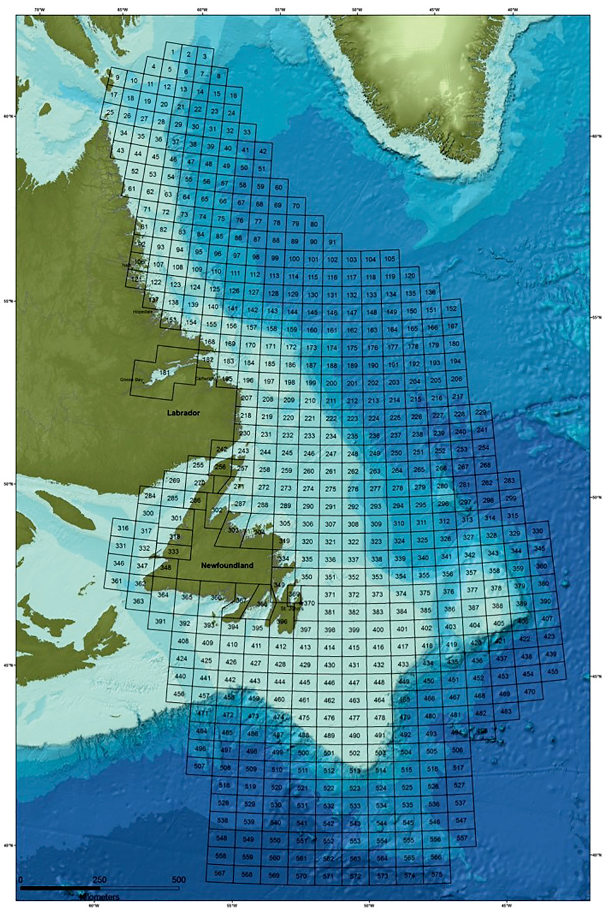
Beginning in 2014, Nalcor partnered with C-Core on a significant regional metocean study for the Newfoundland and Labrador offshore. This study was published in two phases: the first phase covered the Labrador Sea (published in May 2015); the second phase covered the entire Grand Banks and Gulf of St. Lawrence (published in June 2017). The study subdivides the offshore into a grid composed of 575 cells (Figure 4), covering an area of over 2.3 million square kilometers. Each of these grid cells has a detailed comprehensive report on metocean conditions, including: wind, wave, currents, vessel icing, visibility, pack ice, icebergs, and sea surface temperature. This study also has comparisons of each cell’s metocean conditions to other areas of the globe with harsh exploration and development conditions. As well, climatological summaries and trends are discussed in this study.
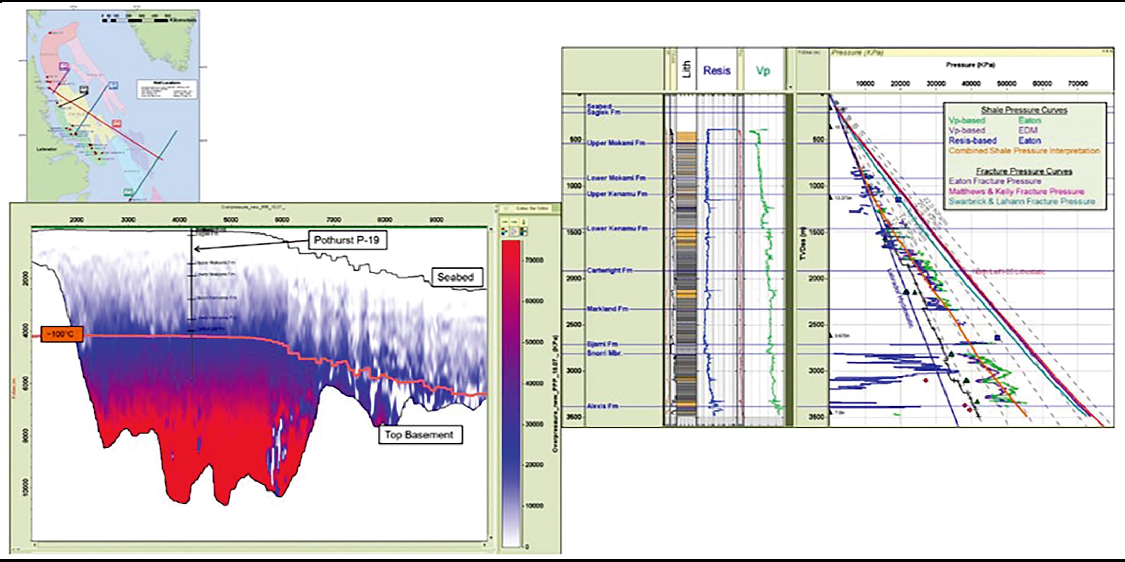
A regional geopressure study was conducted in 2013-14 (IKON Science) in order to examine and interpret pressure and related data from wells drilled on the Labrador Shelf. The area studied included the Saglek, Hopedale (including Nain, Hamilton and Harrison sub basins), and Orphan basins, and the newly mapped slope and deep water, including the Henley, Chidley, Hawke and Holton basins (Carter et al., 2013), where there are no wells drilled to date. The objective was: (a) to provide a framework for future drilling by helping to define the elements of the drilling window (pore and fracture pressure), and (b) to examine how pressure data may improve the quantification and exploration risk of future prospects by, for example, analysis of the risk for mechanical seal failure. A further objective of this study has been the utilization of analogues from either present or ancient deep-water settings globally to help understand how relationships in the shallow water manifest in the deep water. Using a combination of theoretical modeling based on offset relationships, and seismic interval velocity data, the study has produced five vertical pressure profiles, termed TPP’s. Overall, the profiles suggest that deep-water pore pressures will be in a higher range relative to the shelf, with narrower drilling windows, which is typical of deep-water environments globally, (Figure 5). This study is available for download from the nalcorenergy.com/exploration webpage.
A regional rock physics study was undertaken in 2015-16 with IKON Science to establish some fundamental understanding of the relationships between the elastic properties, as sensed by the seismic wave, and the rock properties measured in the well. By coupling these two domains, we have created site-specific rock physics models that reconcile the well data, seismic data, and theory for use in forward modelling scenarios to match seismic anomalies. The models, applicable for uncemented and slightly cemented sediments, are based on a hybrid approach, where we combine theoretical and heuristic models Figure 5. Various results from the geopressure study – 2013. Figure 6. EM results over proven resources – 2014. to describe medium to high porosity clastic sediments. The strength of these models is that the physics behind them is understood and theoretically generalized, hence making them a powerful tool for extrapolating outside well control to match seismic amplitudes of interest. This study is available for download from the nalcorenergy.com/exploration webpage.
In 2014, EMGS conducted a comprehensive multi-client campaign to acquire 3D wide-azimuth CSEM and 3D Magnetotelluric (MT) data over the Flemish Pass and Eastern Orphan Basin, including the Mizzen, Harpoon and Bay du Nord discoveries as calibration points. CSEM measures the electrical properties of the subsurface from the seafloor in a similar way as logging tools measure the formation resistivity in wells. The calibration data acquired (Figure 6) over known wells show that integrated interpretation of resistivity volumes together with available well information and recent 2D seismic data provides another tool to identify and de-risk leads and prospects in the Flemish Pass basin. EM techniques can also give an indication of resistivity trends and information on deep resistors to improve the geologic model of the complex structural and depositional geology of the East Canada Flemish area.
At the crustal scale, gravity data can provide information on crustal structure, while also helping to hone seismic interpretations along the newly acquired seismic reflection lines. Well ties from the shelf allow interpreted syn-rift, drift, and post-drift intervals to be extrapolated to slope and deep-water regions. Due to the variable nature of the basement and overlying strata, however, the character of the basement marker can change from fault block to fault block, resulting in local confidence in the correlation of the horizon, but less confidence between faulted regions. Consequently, gravity data modelling was incorporated into the seismic interpretation process in order to help refine the range of depth to basement and hone the interpretation to allow for regional mapping of the rift package thickness (Welford et al. 2012). The integration of these two data types has resulted in the revision of basement trends, has led to refinement of the basin extents and thicknesses, and has provided further constraints on crustal thickness variations along the Newfoundland and Labrador margin.
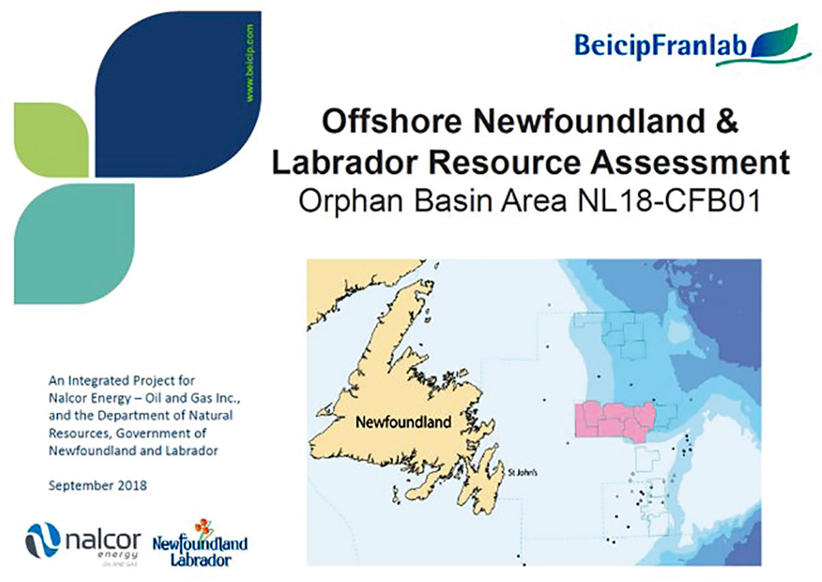
With the initiation of a new scheduled land tenure system by the Canada-Newfoundland offshore Petroleum Board in 2013 (https://www.cnlopb.ca/news/nr20131219/), the exploration cycle in the region has been expanded, allowing more time for detailed geoscientific studies to be conducted prior to a landsale. In advance of any call for bids, Nalcor Energy invests in the collection of 2D seismic data at a 5km by 5km grid or better (i.e. 3D) over the area of interest. This data is interpreted by Nalcor Energy, and Beicip Franlab is engaged to conduct an independent resource assessment (Figure 7) on the upcoming exploration parcels. The results of these studies are publically available prior to the closing of the call for bids (http://exploration.nalcorenergy.com/exploration-reports/resource-assessments/). The Beicip Franlab reports include a detailed geological history of the region and provide ranges of unrisked, in-place volumes calculated from basin modelling work.
Nalcor Energy – Oil & Gas has published many of the above mentioned studies on its website (http://exploration.nalcorenergy.com). Nalcor Energy’s web page also provides other various studies for download, such as biostratigraphic studies and drilling metrics studies for wells in our offshore. As well, Rockwash has completed a multi-client project with Nalcor where all cuttings, core, and thin section data that is available throughout the Newfoundland and Labrador frontier regions has been captured using ultra high resolution photography. The National University of Ireland at Galway conducts an ongoing fluid inclusion study on a subset of wells to assess the historical migration of fluids through reservoir rock within the Newfoundland and Labrador offshore. Many of these studies and their findings are also highlighted in the listing of recent (2010-2018) Nalcor published, authored, and co-authored papers. Lastly, Nalcor has also instituted an easy-to-use tool for capturing the insights of Newfoundland and Labrador’s offshore with our own Nalcor Exploration Strategy System (NESS), which is an interactive tool to be used by others to view our work and projects to date: (http://exploration.nalcorenergy.com/ness/overview).
Conclusions
Recent activity and technical geoscientific work on offshore Newfoundland and Labrador will continue to unlock the area’s secrets and minimize the risk in exploration for years to come. The integrated approach to data collection underpinning the broad regional studies discussed have identified new exploration fairways along the margin and have begun to reduce risk in key elements of prospectivity. While further investigation is required, the results of these initiatives have led to identification of new play trends and hundreds of leads and prospects that will be a focus of future exploration in the region.

Acknowledgements
We wish to thank TGS and PGS for authorization to present the seismic data, Airbus for their authorization to present the slick data, C-Core for the metocean data, IKON Science for the geopressure and rock physics data, Fugro for the seabed coring data, Dr. Welford for the gravity work, and EMGS for the CSEM data. We would also like to acknowledge Beicip-Franlab for their resource assessment work, and finally Nalcor Energy – Oil & Gas is thanked for permission to present this paper. We are grateful to Mike White and Alice Spencer of Nalcor for drafting certain figures.


Join the Conversation
Interested in starting, or contributing to a conversation about an article or issue of the RECORDER? Join our CSEG LinkedIn Group.
Share This Article