Beginning in 1984, a number of earthquakes have occurred in a region of oil and gas production just north of Fort St. John, B.C. Through 1993, 24 events have been detected ranging in magnitude (M) from about M 2.5 to M 4.1. The activity over the past two years has been the most intense with more than half the known earthquakes, including all above M 3.1, having occurred since January 1992. Most were felt, some quite strongly, but there have been no reports of significant damage. The two largest events, M 4.1 on December 26th, 1992 and M 4.0 on January 9th, 1993 were felt with Modified Mercalli Intensities as high as V to distances of about 25 km. There were reports of cracked plaster, fallen pictures and small objects knocked off shelves. People were awakened. In many instances the effects were described as an explosion or a vehicle running into the building.
These earthquakes are unusual for several reasons. This is a region of typically very low-level seismicity on the Interior Platform east of the Rocky Mountain Foreland Fold and Thrust Belt. No earthquakes were detected here before 1984, even though the seismograph network would have allowed location of similar events since the mid 1960' s. There have been no reports of earlier felt earthquakes either. Most unusual, however, is that these events have occurred exclusively during the winter months, November to March. There have only been two winters since 1984 that no earthquakes have been detected, '89-'90 and '90-'91.
The earthquakes have been located in a small area just north of Fort St. John, between Charlie and Cecil Lakes. The epicentres overlie the Stoddart, Eagle West and Eagle oil and gas fields but because their accuracy can not be considered better than about 10 km, it is difficult to associate them with a particular field. There is support, however, from the intensity distributions that the initial 1984 earthquakes were nearer to the west side of the Eagle West field while the most recent events were further east, nearer to the Eagle field. Similarly, although accurate focal depths can not be computed with the existing seismograph network, the relatively high intensities produced by these events do indicate a shallow (upper crustal) source.
Following the January 1993 earthquakes, temporary seismographs were deployed in the area to better locate any possible aftershocks. A number of small events were detected and those that could be located defined an ENEWSW elongated zone about 5 km in length over the Eagle field. Although focal depths could not be determined to better than +/- 2-3 km, the events did appear to be shallower than about 5 km.
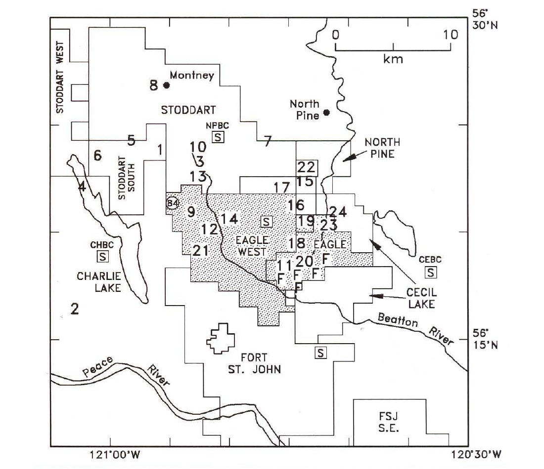
he fields are situated on the Peace River Arch on the north flank of the Fort St. John Graben. The producing reservoirs are mainly within the Permian Belloy Formation at a depth of about 2 km and are controlled and dissected by a number of NE-SW trending normal faults. It is possible that some of these faults are being re-activated by oil and gas production. There are several documented cases of induced earthquakes in other basins elsewhere in the world that are usually attributed to fluid injection or fluid pressure reduction but there may be a variety of causes.
In this case there appears to be both a spatial and temporal correlation with oil production from the Eagle West and Eagle fields. The Eagle West field was discovered in 1976, water injection was initiated in 1980, and the first earthquakes were observed in 1984. The Eagle field was discovered in 1972, water flooding was initiated in 1985 (in 1986 on the east side of the Beatton River that transects the field), and earthquakes were perhaps first observed here in 1992. The seasonality previously noted, however, is not supported by variations in extraction or injection rates and can not yet be explained.
To determine what mechanisms might be involved, the Geological Survey of Canada, Home Oil Company Limited of Calgary, and the B.C. Ministry of Energy, Mines and Petroleum Resources have initiated a seismicity monitoring program in the Fort St. John 6EOarea. Six 3-component digital seismographs were deployed near the Eagle field in November 1993. They are intended to operate to the end of March 1994 with the hope of determining very accurate hypocentres and mechanisms. With these data we should be able to determine the cause of this seismicity and assess its potential hazard - both to the industry and the public.


Join the Conversation
Interested in starting, or contributing to a conversation about an article or issue of the RECORDER? Join our CSEG LinkedIn Group.
Share This Article