The Canadian Cordillera – the mountainous regions of western Canada – represents a world-class natural laboratory for exploring the interconnected Earth systems that are critical to our understanding of major scientific grand challenges. The Canadian Cordillera Array (CCArray) is a proposed international scientific initiative, spearheaded by the creation of a tectonic plate-boundary scale, open-data Earth Systems observational network, that will enable trans-disciplinary research focused on Earth systems processes and boundaries – from Earth’s core to the magnetosphere. During the past few years, regional and national workshops have been held to define high-level scientific targets and geographical regions for a CCArray network in western Canada (Boggs et al 2018a), capitalizing on anticipated domestic and international opportunities for instrumentation, operations and funding. CCArray is highly ambitious, but it represents only the first stage in a proposed national initiative, EON-ROSE (Earth-System Observing Network-Réseau d’Observation du Système terrestrE). This article provides a brief introduction to the scientific vision and objectives of CCArray and EON-ROSE, together with information about the proposed infrastructure and some of the planned research themes. It concludes with a summary of the bright prospects for collaboration between academia, resource industries and governments, local communities and organizations outside of Canada.
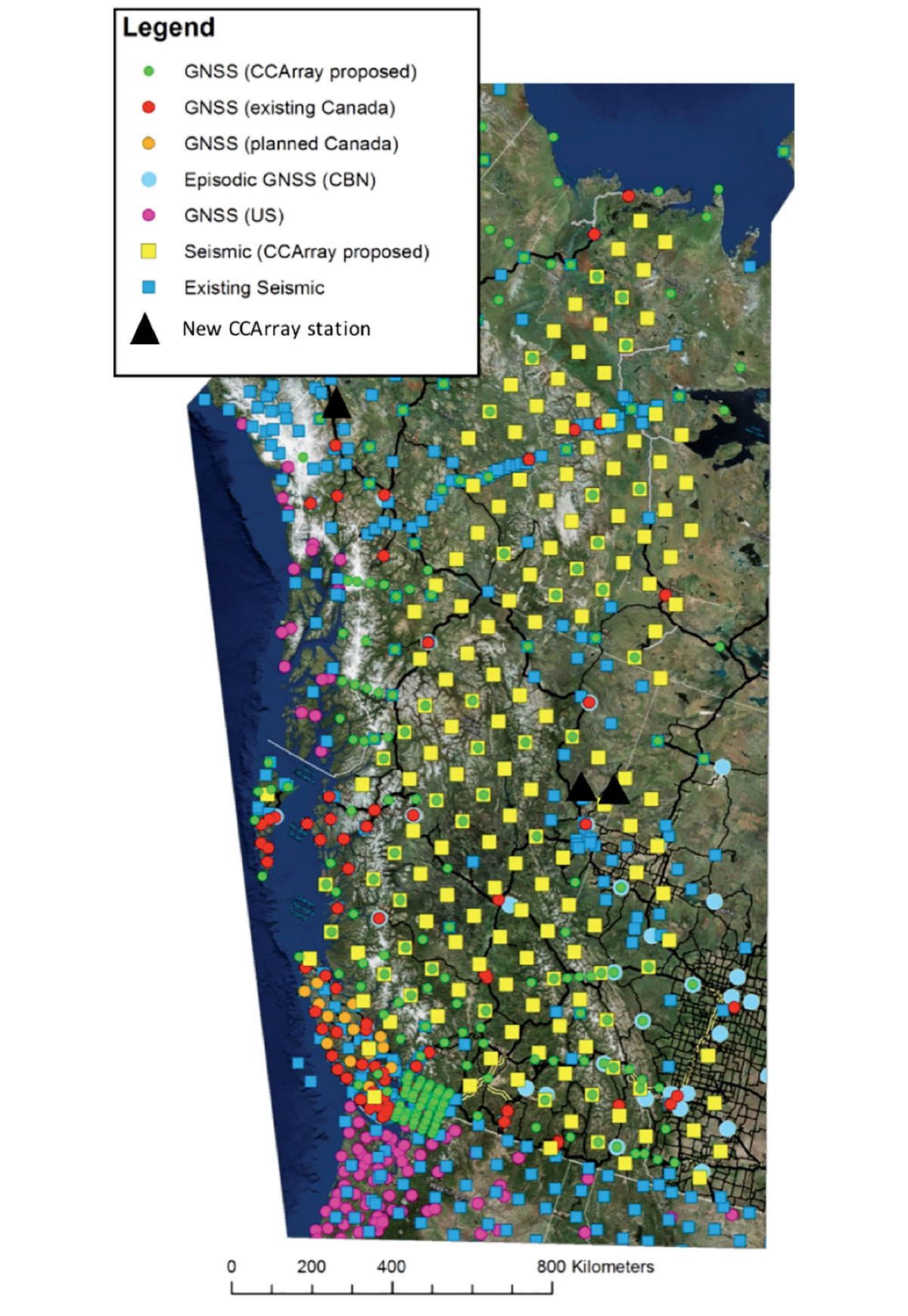
CCArray and EON-ROSE will build upon the scientific momentum of previous Earth-Systems research and data collection initiatives, such as Canada’s LITHOPROBE program (1984 – 2004) and the EarthScope program in the U.S. (2004 – 2019). The aim is to understand and address urgent scientific grand challenges, including the search for natural resources to accommodate the needs of Earth’s increasing population, mitigating natural and anthropogenic hazards and their negative impacts, and becoming environmental stewards in response to global change (NRC, 2012). To better understand and address these challenges, foundational elements of CCArray and EON-ROSE will include installation of a synoptic network of autonomous, real-time, telemetered observatories, and the establishment of an international, transdisciplinary network of Earth science researchers and research institutions. In the case of CCArray, the envisioned instrument distribution depicted in Figure 1 is based on a nominal 85-km grid. Such a network will be highly enabling for a number of key techniques and outcomes that include the use of modern seismological imaging algorithms using passive seismic sources including ambient noise, achieving a relatively homogeneous characterization of natural and anthropogenic hazards, and atmospheric and space weather monitoring. The core of the network instrumentation will be broadband seismometers and Global Navigation Satellite System (GNSS) equipment. This infrastructure will provide the backbone for other proposed sensors at selected sites, including relative and absolute gravimeters, atmospheric, meteorological and magnetotelluric systems.
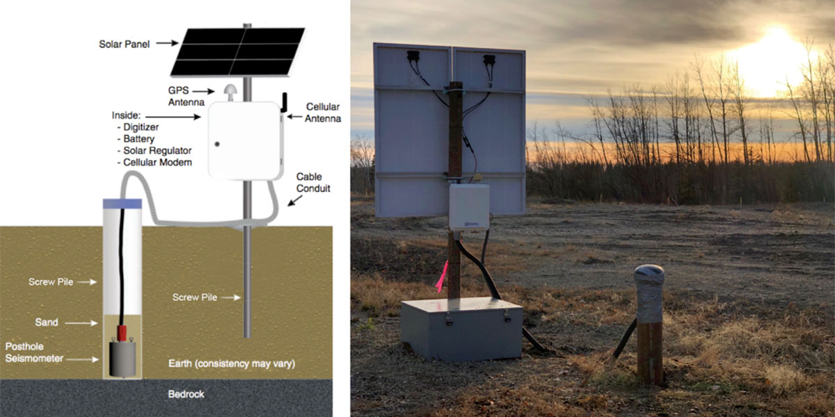
Broadband seismometers record ground motion over a much wider range of frequencies than the bandwidth for seismic exploration, often as low 0.01 Hz (100s period) or lower. The wide frequency range is essential to capture the full range of radiated wave energy from earthquake sources. Figure 2 shows the design for a recently installed broadband seismograph station near Fort St. John, B.C., which represents one of three new stations that have recently been installed as part of CCArray.
Research objectives for CCArray and EON-ROSE that are especially pertinent to geophysics include improving our understanding of Earth structure, tectonics, earthquake occurrence and seismic hazard, glacial isostatic adjustment, induced and triggered seismicity, and determining vertical land motion for robust relative sea-level projections. Other research activities will include the establishment of a network of new Critical Zone Observatories (CZOs) (e.g., Shi et al., 2013) to enable investigation of the wide-ranging ecosystems across Canada. These CZOs will help to establish an environmental baseline to facilitate investigation of wide-ranging ecosystems across Canada, such as mountain glacier change and permafrost dynamics. While Canada currently has some partial CZOs at many university research stations, there are no formally established complete Critical Zone Observatories (Martin and Johnson, 2017). Collectively, these research themes, together with the “big data” that will be acquired as part of CCArray and EON-ROSE initiatives, will furnish unique multidisciplinary platforms for training the next generation of highly qualified personnel in topics ranging from machine learning to tectonics. Education-outreach-communication programs will likewise form an integral component of both of these initiatives through extensive consultation with many Canadian communities, including First Nations communities and the general public.
Selected Research Themes
Tectonic Architecture and Processes
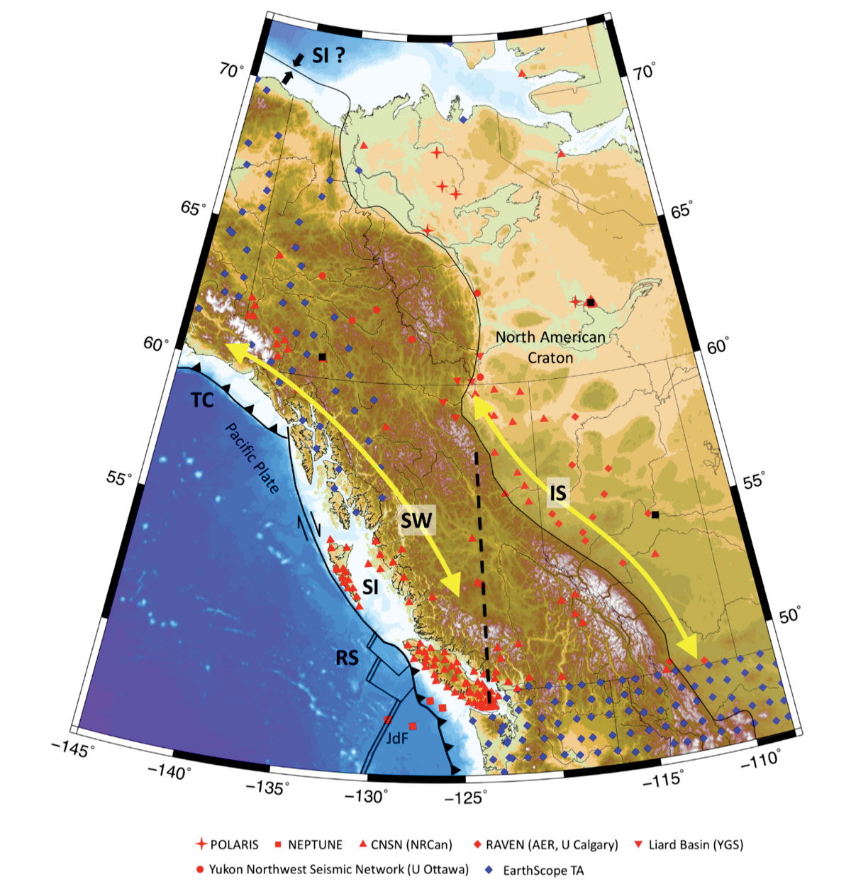
The Canadian Cordillera and adjacent craton constitute one of most tectonically diverse transpressive plate boundary regions on Earth. This region preserves a record >4 Ga of Earth evolution, including episodes of rifting, subduction, terrane accretion and mountainbuilding. The CCArray research program will seek to improve our understanding of the evolution and current tectonics of western Canada, focusing on processes that have governed the development of the Cordillera and how these are reflected in the present-day structure of the crust and upper mantle. Contemporary tectonic processes that will be primary targets of scientific research (Figure 3) include ridge subduction (RS) at the south-north transition from subduction to a transform plate boundary; possible subduction initiation (SI) near Haida Gwaii and along the Beaufort margin; and what may be the largest slab window (SW) in the world, comprised at the surface of terranes that have been translated significantly northward; and oceanic plateau-continent terrane collision (TC), accompanied by strain partitioning and long-distance (~ 800 km) strain transfer. CCArray research will thus delve into complex relationships between present-day plate boundaries and deformation/seismicity of western Canada, including the manner in which pre-existing structures, such as the spatial and depth extent of the craton edge, control its evolution. These topics are best suited to an integrated approach combining geophysical imaging of the lithosphere (primarily based on seismology and magnetotellurics) with geodetic and geological observations of current and past lithosphere deformation, in tandem with geodynamic simulations.
Geohazards Related to Resource Development and Infrastructure
A key scientific focus of CCArray and EON-ROSE will be geohazards that are linked to the development of natural resources, together with associated facilities and infrastructure. Specific research topics will include quantitative characterization of various types of geohazards in western Canada within areas where development of natural resource are ongoing or planned; delineation of the sources of geohazards; and, investigation and simulation of possible interactions between geohazards and anthropogenic activities. Particular attention will be given to two of the most widely known geohazards: induced seismicity (IS) and triggered landslides. The Cordilleran foreland region (Figure 3) has experienced a sharp increase in induced seismicity that has, in some cases, been linked to fault activation by hydraulic fracturing. Improved understanding of natural and induced seismicity and the hazards posed to people, the environment and infrastructure require an improved understanding of the relationship between seismicity and its causes. CCArray research will examine relationships of seismicity patterns to tectonic features and industrial activity associated with development of low-permeability oil and gas resources, including hydraulic fracturing and wastewater disposal. The objective of this research theme is to characterize both natural and induced-seismicity hazards and the factors that control these processes. A multi-disciplinary approach will be adopted to address these challenging issues, using observations from both seismology and GNSS (geodesy). Targeted case studies will be conducted for significant events that have particularly important implications for regional hazard assessment and/ or regulatory considerations.
Mineral Exploration
Over the next twenty years, more than 280 million cars will be electric (Bloomberg NEF, 2018). Construction of these cars will require over 2 million tonnes of cobalt and over 18 million tonnes of copper. Today the annual production of cobalt is only 100,000 tonnes. These electric cars, along with other technologies, will require more copper than has ever been produced (National Committee of Earth Science, 2018). Similar technological demands for other elements, such as Rare Earth Elements, will necessitate the adoption of a “Mineral Systems” approaches to mineral exploration to supply Earth’s growing population into the future.
A Mineral Systems approach emphasizes the role of lithospheric-scale conduits through the sub-continental lithospheric mantle (SCLM) architecture for channeling of ore-forming fluids from the SCLM to form individual ore deposits in the crust. Using gravity, magnetotelluric and densified broadband seismometer deployments, EON-ROSE and CCArray will refine images of these conductive channels in the SCLM across Canada to achieve imaging comparable to the super giant IOCG-U (iron oxide, copper, gold – uranium) Olympic Dam mine in Australia (Heinson et al 2018). This research theme will be informed by known mineral deposits, followed by a synoptic approach that will characterize new areas with high potential for mineral endowment across Canada. Similar government-industry-academic collaborative mineral exploration programs in Australia (e.g. PACE in South Australia) provided a return on investment ratio of 20:1, which included the discovery of the Carrapateena and Khamsin copper-gold mines (Economic Consulting Services, 2014).
GNSS Instrumentation for Crustal Motion and Environmental Parameters
GNSS measurements have applications ranging from measuring crustal motion, determining tropospheric and ionospheric characteristics and time variations, snow and water heights, and soil moisture. Applications of GNSS observations includes seismic hazard assessment, relative sea-level projections, monitoring space weather and atmosphere moisture, earthquake and tsunami early warning, and establishment and maintenance of robust reference frames for surveying purposes.
The Global Positioning System (GPS) is the best known of a number of global navigation satellite systems that provide precise positioning capability for monitoring crustal motion. In this mode, GNSS instruments operate continuously, utilizing geodetic-quality instruments with their antenna mounted on a stable benchmark usually anchored to bedrock, to discern millimeter per year vertical and crustal motion. Broad-scale crustal motions arise from tectonics and postglacial rebound, and a key application is seismic hazard assessment. Land uplift and subsidence at the coasts contributes to relative sea-level change and GNSS measurements enable robust projections of future sea-level change. The Earth’s crust responds to changing surface loads, such as changing glaciers and ice caps, and GNSS measurements contribute to understanding glacier mass balance.
The GNSS satellites transmit radio waves that travel through the ionosphere and atmosphere to the ground-based antennae. During propagation, they are affected (delayed) and the signal received at the antenna gives information on ionospheric variations (space weather) and on atmospheric moisture and pressure. If delivered in real-time or near-real-time, the tropospheric information can be utilized for numerical weather predictions. The ground-based antenna receives the direct signal and signals reflected off nearby surfaces. Analysis of the signal received at the antenna can provide information on snow depth, tidal variations in water height at a coastal installation, soil moisture, and vegetation.
An augmented GNSS network is a core component of CCArray and EON-ROSE. It will provide foundational data for geophysical and environmental scientific research and contribute to key operational goals to keep Canada safe.
Geothermal Energy
A transition to renewable non-CO2 emitting energy sources is critical to mitigate the effects of climate change. Since it is not impacted by variability in sunshine or wind, geothermal energy has the greatest potential to provide baseload electricity compared to other renewable energy sources. Geothermal systems can also provide a source of heating for communities and industry. Enormous geothermal potential exists in many parts of the Canadian Cordillera, as manifested by numerous thermal springs and volcanoes, yet Canada has not harnessed this energy resource. A geothermal energy theme is envisioned as part of CCArray, with a focus on acquiring geoscientific data and developing tools to support the exploration and sustainable development of geothermal resources. Geophysical imaging with seismic and magnetotelluric methods will be combined with structural mapping, fluid geochemistry, heat flow measurements and collection of rock physical properties to aid in defining the occurrence of deep-seated geothermal resources.
Community Science Liaisons, Communications and Community Engagement
Earth’s population will surpass 8 billion by 2030, creating significant strain on demands for Earth’s materials, energy, water and food. Well-informed strategic, economic, consumer, and policy decisions are essential to support this burgeoning population, and as such, the public must have an improved understanding of the need to develop Earth’s resources while promoting environmental stewardship. This requires improved approaches to public education and outreach. CCArray collaborators hope to change the way that science is conducted by promoting two-way conversations between communities across Canada. CCArray will recruit and train Community Science Liaisons (CSLs), who will conduct extensive consultations with their respective communities to better understand how CCArray/EON-ROSE scientists and data can empower them to make fact-based decisions in addressing their local needs and challenges. CSLs will also guide the development of place- and curriculum-based citizen science research programs for K-16 classrooms using data from the proposed Earth Systems Observation Stations. CSLs will liaise in two-way communication: providing scientists with guidance on appropriate interactions with each individual community, while scientists will provide them with guidance and insights in utilizing the scientific process to make accurate and useful interpretations of the provided data. Community groups may be invited to present the results from their citizen science research programs at annual conferences and CCArray/ EON-ROSE scientists will be encouraged to give presentations in communities. Funding may be provided to support interested CSLs to pursue science-related post-secondary education. This approach is intended to create fruitful community engagement across Canada, with the intention of making science mainstream. CCArray/EON-ROSE hopes to train and inspire the scientists of tomorrow as leaders for future generations.
Outlook
The CCArray and EON-ROSE concepts have been developed and refined during the past several years, through a series of virtual townhall meetings, regional and national workshops (Boggs et al., 2018). These workshops have highlighted tremendous synergies that reflect the great potential for collaboration between international academia, various resource industries, as well as federal, provincial and territorial governments and agencies. These collaboration opportunities are being vigorously pursued by the authors and other members of the CCArray/EON ROSE team.
Opportunities for international collaboration are also being actively developed. These efforts have led to co-sponsored workshops and sessions with U.S. agencies, including IRIS, UNAVCO, EarthScope and GeoPRISMS, as well as a nascent collaborative research program with GeoForschungsZentrum (GFZ), the German Research Centre for Geosciences. The goal of the collaborative research program with GFZ is to establish an integrated plate boundary observatory, similar to an existing program in Chile (https://www.ipoc-network. org/welcome-to-ipoc/). Once established, this new plate boundary observatory in western Canada will constitute a significant component of the overall CCArray program. Current plans call for linking together a coordinated program of such major projects, with funding from a variety of sources. CCArray will thus develop into a pilot initiative that will provide a foundation for establishment of the national EON-ROSE program.
Advances in geophysics have contributed to improved understanding of Earth structure and processes, yet many Grand Challenges remain to be addressed. Timely answers to questions that underlie these grand challenges are essential in empowering our society to cope with some of the daunting challenges facing current and future generations. Advancements through CCArray and EON-ROSE could assist in a number of important ways, including the search for natural resources to sustain Earth’s population, mitigating natural hazards and environmental stewardship.

Acknowledgements
This article summarizes work that has emerged from numerous discussions and workshops, with important contributions from Michael Sideris, Malaika Ulmi, Mostafa Fayek, Roy Hyndman, Claire Currie, Martyn Unsworth, Honn Kao, Rick Aster, Jeff Freymueller, Bob Busby, Bob Woodward, Bob Detrick, Brian Menounos and many others. For more information about CCArray, please contact one of the authors or see www.ccarray.org. This is Natural Resources Canada contribution number 20180323.


Join the Conversation
Interested in starting, or contributing to a conversation about an article or issue of the RECORDER? Join our CSEG LinkedIn Group.
Share This Article