Located in Canada’s easternmost province of Newfoundland and Labrador, researchers at Memorial University are ideally positioned to undertake geophysical research along the country’s Atlantic margins where offshore exploration is still very much at the frontier stage, spurred on by world-class discoveries and production in the Jeanne d’Arc and surrounding basins. Building upon an established history of generating foundational knowledge of our offshore margins and petroliferous sedimentary basins, continued investment in and support of an evolving pool of faculty, researchers and students in geophysics, the future of geophysical education and research in the province looks bright. From the regional crustal scale, through the basin scale, to the reservoir scale, this article provides an overview of current efforts to better understand, characterize, and responsibly develop this very important section of Canada’s East Coast margins.
Introduction
Canada’s submarine limits on the East Coast consist of rifted continental margins that formed during the opening of our modern-day oceans. These rifted margins host many of our country’s most valuable resources. At Memorial University, members of the Geophysics Group are actively undertaking geophysical research to expand our understanding of the structure and evolution of these margins and their basins, to improve on the methods used to probe these offshore structures, and to better image, characterize and monitor the reservoirs hosting these valuable resources. Combined, these studies have a direct economic and territorial impact on a significant portion of Canada’s resource economy while contributing to global knowledge of rifting processes, geophysical methods, and reservoir characterization.
Department Overview
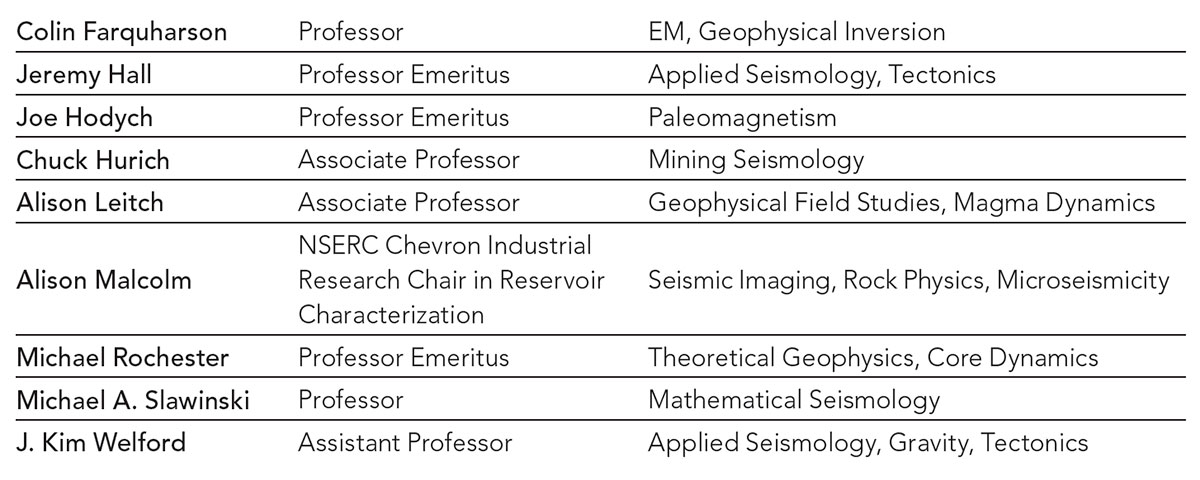
The Geophysics Group at Memorial University is comprised of more than 40 people, including faculty (see Table), Research Associates, Post-Doctoral Fellows, and graduate and undergraduate students. We engage in research utilizing field, laboratory, mathematical and computational techniques to address a comprehensive range of questions in tectonics, seismology, paleomagnetism, and exploration and environmental geophysics.
Our facilities include high performance computers with state-of-the-art software; a spectrum of geophysical field equipment; and specialized laboratories for studying the physical properties and behaviours of Earth materials.
Our undergraduate program is professionally accredited. After 2 years of grounding in geology and the basic sciences, students in the geophysics stream take up to 8 senior level courses covering seismology, potential fields, and electrical and electromagnetic methods as well as tectonics and mathematical and numerical analysis. Practical exercises and field experience are emphasized. In 2017-18, 9 geophysics-stream students graduated, 7 with an Honours degree. These numbers are typical for the last decade and more.
The Geophysics Group is also fortunate to continue to attract exceptional graduate students from within the province, across the country, and internationally. In 2017-2018, a total of nine students graduated from the geophysics stream (8 MSc and 1 PhD), with most going on to careers in industry. A dozen PhD students and a greater number of MSc students are actively contributing to geophysical research at Memorial and to the energetic atmosphere of scientific enquiry that continues to buoy the broader Department of Earth Sciences.
Significant research efforts within the Geophysics Group are undertaken in direct collaboration and with funding support from industry partners, with East Coast margin work specifically supported by Chevron Canada Ltd., Husky Energy Inc., Suncor Energy Inc., Hibernia Management and Development Company Ltd., and Nalcor Energy – Oil and Gas. Further funding is provided by federal (NSERC) and provincial (InnovateNL and Mitacs) sources. This invaluable support highlights the value that industry and government place on increasing knowledge of offshore East Coast margins and basins, and on training Canada’s future geoscientific leaders in Newfoundland and Labrador.
History of Geophysical East Coast Margin Research
The Geophysics Group at Memorial University has an established history of East Coast Margin research that has provided an invaluable contribution to both a regional and global understanding of the development and evolution of offshore sedimentary basins and their resources. At the forefront of this research has been Dr. Jeremy Hall, Professor Emeritus, and his seismic investigations of continents and their margins through, most notable for the East Coast margins, the national LITHOPROBE project, for which he played key scientific and supervisory roles. The LITHOPROBE studies undertaken at Memorial were crucial for establishing the tectonic framework of the Appalachian Orogen and for reconstructing the evolution of the Precambrian structural provinces of Labrador, both onshore and offshore (Hall et al., 1998, 2002). In 2000, the SCREECH (Study of Continental Rifting and Extension on the Eastern Canadian Shelf) Project, in which Memorial researchers played an important role, probed the seaward limit of the continental shelf of Newfoundland and Labrador, across the transitional continent-ocean boundary zone, and into oceanic crust, using seismic reflection and seismic refraction surveying (Lau et al., 2006; Deemer et al., 2009, 2010). This work complemented drilling results from Leg 210 of the Ocean Drilling Project (Shillington et al., 2004) and extended our understanding of the rifted crustal structure of the margin, the nature of the transition zone, and the character of overlying sediments. Additional deep seismic work around the margins of Flemish Cap as part of the Erable project (Welford et al., 2010a, 2010b) allowed that understanding to be extended further north along the margin toward the enigmatic Orphan Basin, where subsequent seismic interpretation and analysis of industry data, provided by TGS, revealed increasing rift complexity (Gouiza et al., 2015, 2017).
These deep crustal seismic reflection and refraction studies undertaken by Memorial researchers, coupled with complementary geodynamic and basin analysis work from former Memorial faculty members Dr. Garry Quinlan and Dr. Michael Enachescu, have improved our understanding of the origin and deformation history of offshore sedimentary basins, knowledge that has benefited the petroleum industry in Newfoundland and Labrador.
Over many decades and on an ongoing basis, geophysical research at Memorial University has benefited from strong partnerships with the petroleum industry. The Hibernia Project Geophysics Support Fund has been instrumental in supporting dozens of students and post-doctoral fellows as well as geophysical investigations within the province. Most recently, these industrial partnerships were fundamental to the creation of the NSERC Chevron Industrial Research Chair in Reservoir Characterization, to which Dr. Alison Malcolm was appointed in 2016.
Current Geophysical East Coast Research
The remainder of this article focuses on the research of three of our faculty: Dr. Kim Welford, who leads the MAGRiT group focused primarily on the tectonics and basins of the East Coast margins, Dr. Alison Malcolm, whose research focuses on the development of techniques for reservoir characterization that are applicable to the East Coast margins, and Dr. Colin Farquharson, whose work on implementing improved modelling methodologies for electromagnetic data has been successfully applied on the offshore East Coast basins.
Characterization of Rifted Continental Margins and their Conjugates
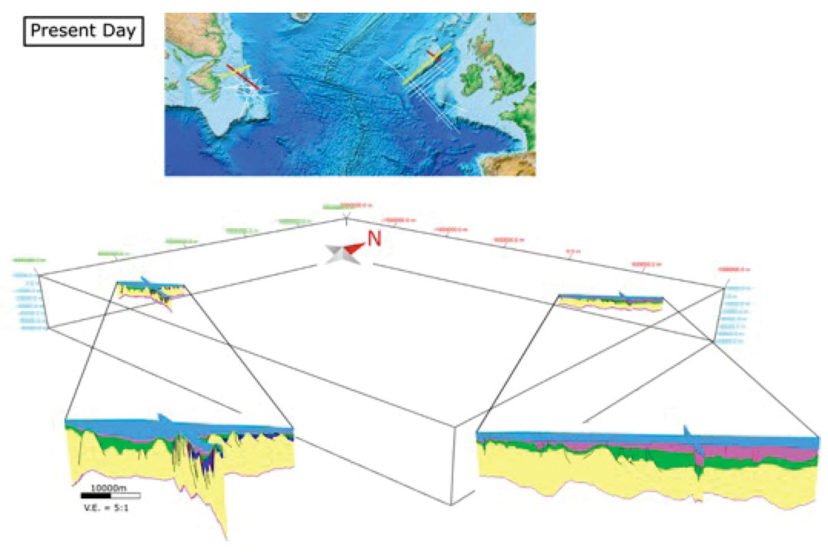
Using a combination of seismic reflection, seismic refraction, and potential field studies, the members of the Memorial Applied Geophysics for Rift Tectonics (MAGRiT) group are contributing to an improved global understanding of rifted continental margins and their conjugates, the sedimentary basins that overlie them, and the fundamental processes that shaped them. Through field studies of shallow structures and improved imaging and modelling of deep structures, both onshore and offshore, we are providing an improved understanding of the non-volcanic rifted margins that make up offshore Newfoundland and Labrador and also the conjugate margins from which they separated during the opening of the North Atlantic Ocean. Many of the offshore basins overlie regions of anomalous rifted continental crust with structural and thermal regimes that both impacted the overlying sediments and hold clues about fundamental rifting processes. These processes are currently being investigated using seismic interpretation studies of sedimentary basins across conjugate margin pairs (Figure 1; MacMahon, 2018; Sandoval et al., 2018), seismic reprocessing studies for improved imaging (Welford et al., 2010a, 2010b), magmatic asymmetry studies (Peace et al., 2018a, 2018b), plate reconstruction studies (Peace et al., 2018a; Welford et al., 2018), and gravity inversion studies (Welford & Hall, 2007, 2013; Welford et al., 2012, 2018).
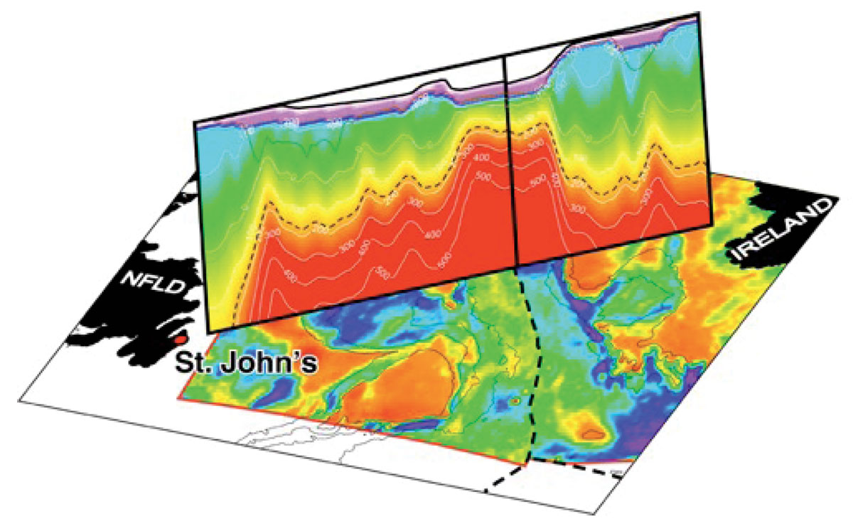
Gravity Inversion Studies of Rift-Related Structures
Deep crustal seismic surveys of rifted continental margins are often sparsely distributed, limiting their usefulness for characterizing broad regions. Gravity data provide one geophysical means of bridging between sparse seismic lines. Using constrained 3-D gravity inversions, the regional density distribution beneath entire offshore margins can be obtained and used to infer crustal structure (Figure 2; Welford & Hall, 2007, 2013; Welford et al., 2012, 2018). Existing gravity inversion codes, developed for the mineral exploration industry, can be used for crustal studies but are not designed to generate layered models with abrupt density contrasts (such as at the base of the crust) using only sparse constraints. Members of the MAGRiT group have developed new gravity inversion algorithms that can incorporate the necessary geological constraints for deep crustal regional studies with sparse seismic constraints (Geng et al., 2017; Welford et al., 2018). One such improved gravity inversion method has also been successfully applied to modelling onshore occurrences of rift-related magmatism that complement surface geology structural mapping (Peace et al., 2018b).
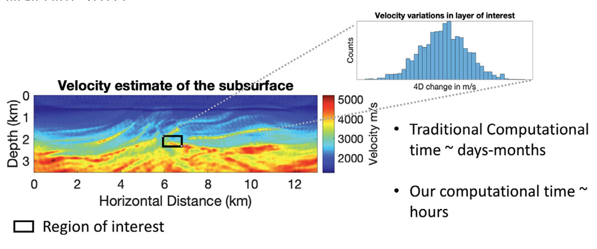
Quantifying Uncertainty in 4D Seismic Imaging
Several 4D seismic surveys are either completed or planned for offshore Newfoundland and Labrador. The reservoir geometry and geology present in this region are at the border of what we can reliably image with current 4D technology. This begs the questions: What can we image? And how do we know we’ve imaged correctly? This leads us to try to better understand the uncertainties in seismic images and velocity models with a particular focus on 4D. Seismic images and seismic-derived velocity models are routinely used to determine reservoir properties, but are rarely produced with a realistic, rigorous uncertainty. One reason that uncertainties are not routinely estimated is that it is computationally challenging to explore the range of possible images and models that fit the data. This challenge is mitigated for 4D data because we are generally interested in only a small sub-region of the total domain and because a good model of the region is typically available. Dr. Malcolm’s group takes full advantage of these two aspects of the 4D problem to locally estimate uncertainties in a computationally tractable way (Figure 3; Ely et al., 2018; Kotsi et al., 2018; Willemsen & Malcolm, 2017).
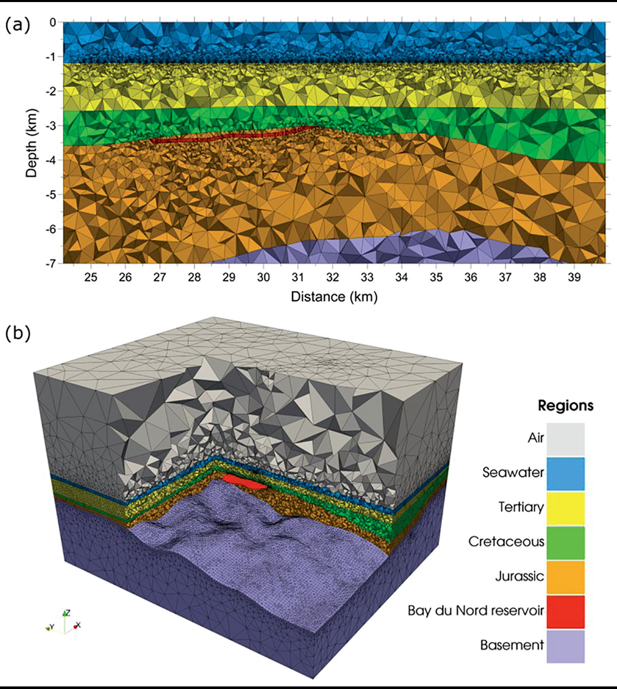
Controlled-source Electromagnetic Investigations of Offshore Basins
Quantitative interpretation of geophysical data relies on the ability to compute synthetic data for a prospective Earth model. To that end, members of Dr. Farquharson’s research group are developing the computational mathematics and software for synthesizing data acquired by all types of geophysical electromagnetic methods, encompassing the complexities of the actual subsurface of the Earth. This is being achieved by considering finite-element and finite-volume methods to numerically solve Maxwell’s equations for the electric field or for vector and scalar potentials, and by using unstructured tetrahedral meshes to discretize the Earth models. These methodologies have been successful in reproducing data acquired over real geological features, including marine CSEM data from over hydrocarbon reservoirs offshore Newfoundland and Labrador (Figure 4; Nalepa et al., 2016; Squires, 2016; Dunham et al., 2018).
Conclusions
Geophysical research on Canada’s East Coast margins is alive and well at Memorial University, from the regional crustal scale to the reservoir scale. Building on a solid history of geophysical achievements, a renewing group of researchers and students are poised to make new discoveries and push the frontiers of knowledge ever further. Strengthening relationships with industry partners will be essential for achieving those goals.

Acknowledgements
We would like to acknowledge support from the Hibernia Project Geophysics Support Fund (provided by Hibernia Management and Development Company Ltd.), as well as Chevron Canada Ltd., Husky Energy Inc., Suncor Energy Inc., Nalcor Energy – Oil and Gas, NSERC, InnovateNL, Mitacs, and others, without which the research highlighted here would not have been possible. We would also like to thank TGS as well as the Petroleum Affairs Division of the Department of Communications, Climate Action and Environment, of the Irish government for generously providing seismic reflection data sets. The Canada-Newfoundland and Labrador Offshore Petroleum Board (C-NLOPB) is also thanked for providing additional geological and geophysical well logs and data. Figures for this article were prepared and adapted by Michael Dunham, Maria Kotsi, and Heide MacMahon.


Join the Conversation
Interested in starting, or contributing to a conversation about an article or issue of the RECORDER? Join our CSEG LinkedIn Group.
Share This Article