Abstract
Combined with susceptibility of volcanic rock determined from core samples, an improved algorithm for separation of potential field anomalies can increase the resolution of magnetic data. In areas with abundant information, joint processing and interpretation of seismic, electrical and magnetic data can significantly enhance the prospecting effect. Within this context, magnetic method has special advantages in recognizing volcanic reservoir. There have been many such successful applications in China. The paper introduces several typical and successful cases released in China. These cases of history demonstrate the ability of magnetic data in detecting and delineating igneous rocks and volcanic reservoirs.
Introduction
In Tarim Basin, northwestern China, widely developed volcanic rocks cause poor signal-to-noise ratio in seismic data, thus make the investigation of prospective traps more difficult. One may choose to steer away from areas of with well developed volcanic rocks, but such volcanic regions often host rich gas reservoirs1 as have been discovered in Junggar Basin and Songliao Basin of China. Thus, detection and delineation of volcanic rocks have gained much attention in petroleum exploration.
In fact, in some complex areas with widely developed volcanic rocks, much work has been done to recognize lithology and lithofacies of such volcanic units based on seismic data. Cai et al.2. utilized multi-well constraint method and some special and effective processing and interpretation methods of seismic data to study the distribution of volcanic rocks and reservoir formation. Cao et al.3. put forward a method on the use of high precision seismic data to investigate the location of craters in deep underground and identify volcanic facies. Li et al.4. also developed a method for the quantitative estimation of volcanic reservoir beds in deep underground4. In complex areas with widely developed volcanic rocks, however, it is difficult to recognize lithology and facies of volcanic rocks only by seismic data. This is due to the special physical property and inner structure of volcanic rocks. Usually, seismic reflection can describe the configuration of volcanic rocks but can’t indicate its lithology and facies. More effective seismic methods are still being investigated.
Volcanic rocks with different lithology show different physical properties such as density, susceptibility, resistivity, and so on. These differences, especially magnetic contrast between volcanic rocks with different lithology and facies establish an effective basis for the recognition of volcanic rocks. If configuration of volcanic rock inferred on the basis of seismic data can be combined with the physical properties estimated on the basis of magnetic and EM data using high precision and integrated interpretation methods, the problem of recognizing volcanic rocks can be readily tackled.
In this paper, we first give a brief introduction to the data processing methods for the recognition of volcanic rocks by means of magnetic data. We then describe a number successful cases that are typical of exploration in such settings in China.
Magnetic features of volcanic rocks
Based on numerous core samples from the study area, physical properties of rocks are determined. Usually, volcanic rocks show higher susceptibility than common sedimentary rocks. The latter usually have susceptibilities lower than 1 to 100×10-5SI. In contrast, acidic volcanic rocks show susceptibilities of 100 to 500×10-55SI, neutral ones always higher than 200 to 1000×10-5SI, while basic volcanic rocks have susceptibility in the range of 500 to 2000×10-5SI. Thus the susceptibility of volcanic rocks can be 20 times as high as that of sedimentary rocks. Accordingly, sedimentary rock, acidic volcanic rock, neutral one and basic one shows ascending susceptibility in turn. So, basic volcanic rocks may cause higher magnetic anomalies than neutral one, acidic one and sedimentary rock, and volcanic rock shows higher susceptibility than sedimentary rock, while the latter often causes negative anomalies.
Methods for separation of magnetic anomaly
Commonly, regional field can be estimated by low-pass filtering or upward continuation. Then removing regional field from measured magnetic anomaly yields the remained called residual magnetic anomaly. By means of spectrum analysis and spatial filtering5, magnetic anomalies can be separated. In recent years, wavelet transform6 and neural network7 methods have also been applied in the separation of gravity and magnetic anomalies.
The choice of a separation method depends on actual conditions. If the sedimentary formations are of zero or low magnetism, volcanic rocks are underdeveloped and subsurface strata are smooth, the configuration of magnetic anomaly will not be impacted by sedimentary formations. Thus, magnetic anomaly should be caused mainly by deep targets. By means of higher order derivatives, magnetic anomalies sourced from deep volcanic rocks can be extracted. If volcanic rocks are widely present in shallow regions underground, second derivative of magnetic data can only reflect the distribution of shallow magnetic bodies. To investigate deep volcanic rocks, other geophysical data are required to remove the effect from shallow volcanic rocks. Usually, there are three approaches. The first is combining magnetic method with seismic method. On the basis of primary configuration of shallow volcanic rocks inferred from seismic data, 2D joint processing of multiple lines can model shallow anomalies and remove them from measured data, thus deep magnetic anomalies can be obtained. The second is combining magnetic method with electromagnetic method. We know that volcanic rocks are of high resistivity and the corresponding features are apparent on EM sounding sections. 2D processing can again model shallow magnetic anomalies in order to extract deep magnetic anomalies. The third is combining magnetic method with gravity data thereby comprehensively interpreting volcanic rocks.
4 Cases
1) Recognizing attributes of seismic reflection anomaly in TZH area
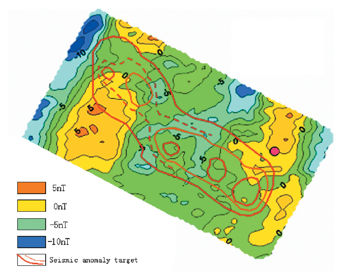
In an exploration areas known as TZH, reflection anomalies appear at 6000-m depth on the seismic section. The question is whether these anomalies are reef mass or volcanic rocks? If they are reef mass, a large petroleum reservoir may exist there, but if they are volcanic rocks, planned wells should be kept away from the areas with volcanic rocks. The geological attribute of these anomalies is difficult to determine solely based on seismic method. The magnetic data exhibit a slope belt whose magnitude is high on the southeast and low on the northwest. According to released data, there is no volcanic rocks developed in shallow underground, thus there is no apparent local magnetic anomaly. We have carried out a regiona-residual separation to obtain the residual anomaly (Figure 1). Red lines in the figure describe the range and configuration of anomalous bodies inferred on the basis of seismic data. It is obvious that deep residual magnetic anomaly extends northeastwards while seismic anomalous bodies northwestwards. So, the seismic-derived anomalous bodies should not be volcanic rocks. To verify the seismic and magnetic interpretation, the client oilfield company designed aa test well (marked in Figure 1 by the magenta dot) at a crest of seismic reflection coinciding a with high magnetic anomaly on the eastern part. The drilling indicated that the magnetic anomaly is due to volcanic rocks. The case proved the importance of magnetic prospecting in well planning based on the contrast of seismic and magnetic interoretations.
2) Investigation of volcanic rocks in TY area
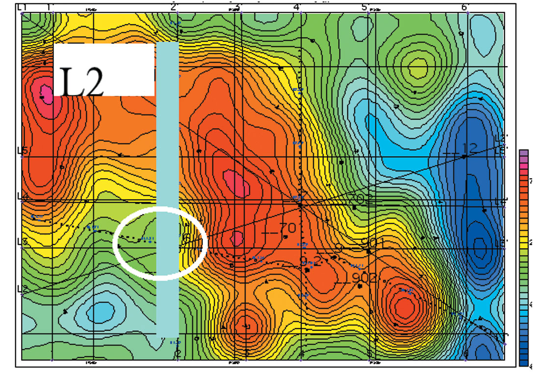
TY is located on the northern Tarim Basin, China. Reservoirs connected to buried hills are well developed there. Several finished wells in the area give evidence to the abundance of petroleum resources in TY area. In the area, not only volcanic rocks are widely developed and their lithology and facies are very complex and variable, all other geophysical anomalies also show complex characteristics that are confusing on seismic section. Many years of experience in petroleum prospecting and exploration indicates that volcanic rocks are the major factors that disturb the recognition of low-amplitude structure in the area. On the other hand, volcanic rocks may also be an advantageous aspect for the formation of petroleum reservoir. Several traps accompanied by neutral-to-basic volcanic rocks have been discovered in the area, but acidic or neutral-to-acidic intrusive rocks are disadvantageous factors. Lithologic studies indicate that acidic and neutral-to-acidic intrusive rocks are of high resistivity and medium susceptibility, while neutral-to-basic volcanic rocks (eruptive rocks) are of high resistivity and high susceptibility. To investigate the distribution of volcanic rocks and their lithology and facies, high precision magnetic and TFEM methods are jointly utilized to predict favorable drilling locations. A well is planned on the basis of seismic interpretation, which is indicated by a pale circle in Figure 2, residual magnetic anomaly map. The deep magnetic anomaly is of medium susceptibility on the map, and a high resistivity mass appears at the same position on 2D constrained inversion section of TFEM data in Figure 3. Taking the known lithology information of the area into consideration, it is possibly acidic or neutral-to-acidic intrusive rocks, thus it is an unfavorable target. Well E16 drilled subsequently penetrated the acidic intrusive rocks at 6000m deep. East to the well is a favorable trap of volcanic reservoir where a finished well E7 yields commercial oil flow.

3) Detection of deep volcanic reservoir in STH Basin
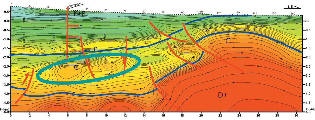
Well M17 in TSH Basin discovered remarkable gas resources in Carboniferous volcanic rocks, which means a great prospect of gas resources in the basin. Due to the overlying volcanic rocks, however, seismic data cannot definitely indicate the development and distribution of Carboniferous volcanic rocks. Thus, TFEM and magnetic surveys are deployed to detect volcanic mass favorable for gas accumulation. Figure 4 is the resistivity section of 2D constrained inversion of TFEM data. The section clearly indicates a layer with relatively high resistivity at a 2.5- km depth, which may be Permain volcanoclastic rocks with overflow facies. According to physical property of core samples, the layer is of low susceptibility and well bedded, but shows poor storage capacity. A resistive block appears below 2.5km, but it is difficult to infer whether the unit is volcanic rock or carbonate rock. Presence of a volcanic rock unit would be a prospective reservoir and may contain oil gas. If it is carbonate rock, the prospect would be rather poor. Figure 5 is the residual magnetic anomaly map, which mainly reflects the development of magnetic bodies at depth. Comparing the map with resistivity section from 2D inversion of TFEM data, we can find that the resistive block corresponds to the magnetic anomaly with high magnitude. So, the anomalous body is inferred to be Carboniferous volcanic rocks. Considering well M17, it maybe a most favorable reservoir of Carboniferous volcanic rocks.
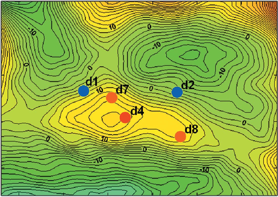
4) Predicting reservoir of Carboniferous volcanic rocks in ZD Basin
Carboniferous volcanic rocks are usually buried at about 3300m deep in the area and reservoir beds are always neutral-to-acidic volcanic rocks with medium susceptibility. Magnetic anomaly with a low magnitude of 3 to 4 nT is obtained by means of subbalance filtering method. The topography is flat and there is no surface disturbance in the area, and the anomaly is of large size, so the weak anomaly is highly reliable and should correspond to volcanic rocks. Modeling shows that the weak anomaly is sourced from neutral-to-acidic volcanic rocks (medium-to-low susceptibility) with magnetic intensity of 350×10-3A/m buried at 3300m to 3800m deep (Figure 6). The anomaly matches well with seismic-based prediction. Two wells d1 and d2 have been planned in the area, and have good show of oil and gas but yield no commercial oil flow. Reliable range of volcanic rocks is mapped on the basis of magnetic anomaly, then 3D seismic survey is deployed to verify the mapped range, finally well d4 is planned, which discovers gas flow with large capacity, thereby discovering a new gas reservoir. Delineation wells d7 and d8 planned subsequently delineate the reservoir. The range of magnetic anomaly matches well with later drilling result.
Conclusion
Magnetic data can reflect volcanic rocks well, so it is a necessary approach to the investigation of igneous rocks. Recently, igneous reservoirs discovered in China gained much attention from oilfields. Consequently, magnetic method is seeing more and more opportunities in hydrocarbon exploration. Special techniques of data processing make it more reliable to use magnetic anomaly to detect and delineate such igneous units in different depths, thereby making it feasible to delineate potential targets. However, their lithology should be determined by removing shallow anomaly on the basis of seismic or EM method, or a combination of both. The cases introduced in the paper demonstrate that it is an effective approach to the investigation of complex volcanic reservoir by combining magnetic method with other geophysical ways.

Acknowledgements
This work is in part supported by a grant from China Science 863 Plan (2006AA06Z201). We thank Dr. Satinder Chopra for the encouragement to submit this article and Professor Yaoguo Li for his help with the manuscript. We also thank Sun Weibin, Liu Haiyin, and He Yi for their contribution and help.


Join the Conversation
Interested in starting, or contributing to a conversation about an article or issue of the RECORDER? Join our CSEG LinkedIn Group.
Share This Article