Introduction
For the first part of 2003 wholesale natural gas prices have been in the range of 4 to 6 $US per million btu, this compares to prices of about 2.2 $US in 1998. The price increase reflects increased demand and a decrease in reserves within USA and Canada. In fact, production probably peaked in the Western Canadian Sedimentary basin that extends from Alberta into northeastern British Columbia at about 6.3 Tcf/yr in 2001. It is now at about 6 Tcf/yr. and of this total about 2 Tcf is exported to the USA. These production totals include the production of 1.3 Tcf/yr (2003) from the British Columbia part of the basin.
British Columbia has proven natural gas reserves of 9 Tcf with an undiscovered potential resource of 50 Tcf in the northeastern part of the province. The USA with natural gas reserves of 167 Tcf uses close to 21 Tcf per year and this is projected to grow to 25 Tcf/yr, which will mean that import requirements could be over 5 Tcf by 2010. This amount of gas will not be available from the Western Canadian Sedimentary basin or from other basins or the north shore (Mackenzie Delta and Alaska) based on the capacity of planned pipelines.
All these resource and production numbers vary depending on the source, but the picture is clear, natural gas reserves within Canada and continental USA are running out and at present and predicted rates of consumption will probably last less than 30 years (some predictions are as short as 10 years). If we are to continue with the present ratio of energy consumption per person then there are three alternatives to provide new gas supplies. These are tight gas resources, imports of liquefied natural gas or coalbed methane (CBM or sometimes referred to as coalbed gas CBG). At present 8% of the gas produced in continental USA is CBM and this amounts to 1.56 Tcf/yr (2003). In Canada there is limited production in Alberta and at present no CBM production in British Columbia. Within western Canada and especially British Columbia there is tremendous incentive to make CBM work.
British Columbia has a measured coal resource of over 3 billion tonnes. This is really an estimate of coal available for surface and underground mining. Therefore to some extent it is an estimate of the coal resource that is not favorable for CBM exploration because it is too shallow. The estimated coal resource to a depth of 2000 metres, which is the resource available for CBM exploration, is in the range of 250 billion tonnes. The potential CBM resource in this coal is about 90 Tcf. This resource number should not be confused with a reserve, which represents an estimate of the amount that can be economically recovered. The percentage of this 90 Tcf resource that may eventually be recoverable may be small (10% or less). In developed CBM basins in the USA the predicted percent of resources that will eventually be recovered varies from 10 to 62% and in these basins there is a lot of data to improve the accuracy of the prediction.
Coal in British Columbia is distributed throughout the province. Deposits are found in Upper Cretaceous rocks on Vancouver Island and in Tertiary basins in the interior of the province. Most of the coal in the province is found along the trend of the Rocky Mountains, which are underlain by three coal-bearing formations. These formations of Jurassic to early Cretaceous age were involved in the Tertiary deformation that formed the Rocky Mountains. This produced some spectacular scenery but also produced challenges for CBM exploration. Successful CBM production requires coal seams that are not too fragmented by faults and that maintain sufficient permeability for the gas to migrate though seams to the wellhead. Permeability is of overriding importance for a CBM exploration program to succeed and is largely dependent on cleats, which are tensional fractures characteristic of coal. Consequently they probably (but not exclusively) form when the coal is at relatively shallow depth, either during burial or during uplift.
There has been considerable interest in the CBM potential of British Columbia for the last 25 years. There was a spike of CBM exploration in 1990 when eight holes were drilled in southeast British Columbia. This was followed by a lull till 2000 when EnCana acquired CBM exploration rights in most of the Elk Valley in southeast BC. Other companies started exploring in the province and holes have been drilled in northeast BC and on Vancouver Island. At the moment exploration is planned or is under way on two projects in northeast BC and one in the Princeton area. EnCana continues to test two pilots in the Elk Valley where to date they have drilled 17 holes. Some of the companies that are or have been active in the province include, EnCana, BP, Northstar, CDX, Talisman, Koch, Burlington and Peace River Coal Corporation. It is difficult to estimate but the total expenditure on exploration in the province is probably over 50 million dollars with an additional 20 million dollars in land sales
Summary of CBM Resource Potential in British Columbia
Coal in B.C. occurs in a number of different geological environments. Each has different implications for CBM development.
About 80% of the coal resource in the province is contained in a number of Upper Jurassic to Lower Cretaceous coalfields in the foothills of the Rocky Mountains (Figure 1). These coalfields are within fold and thrust belts and are defined by continuous outcrop or subcrop of coal bearing formations.
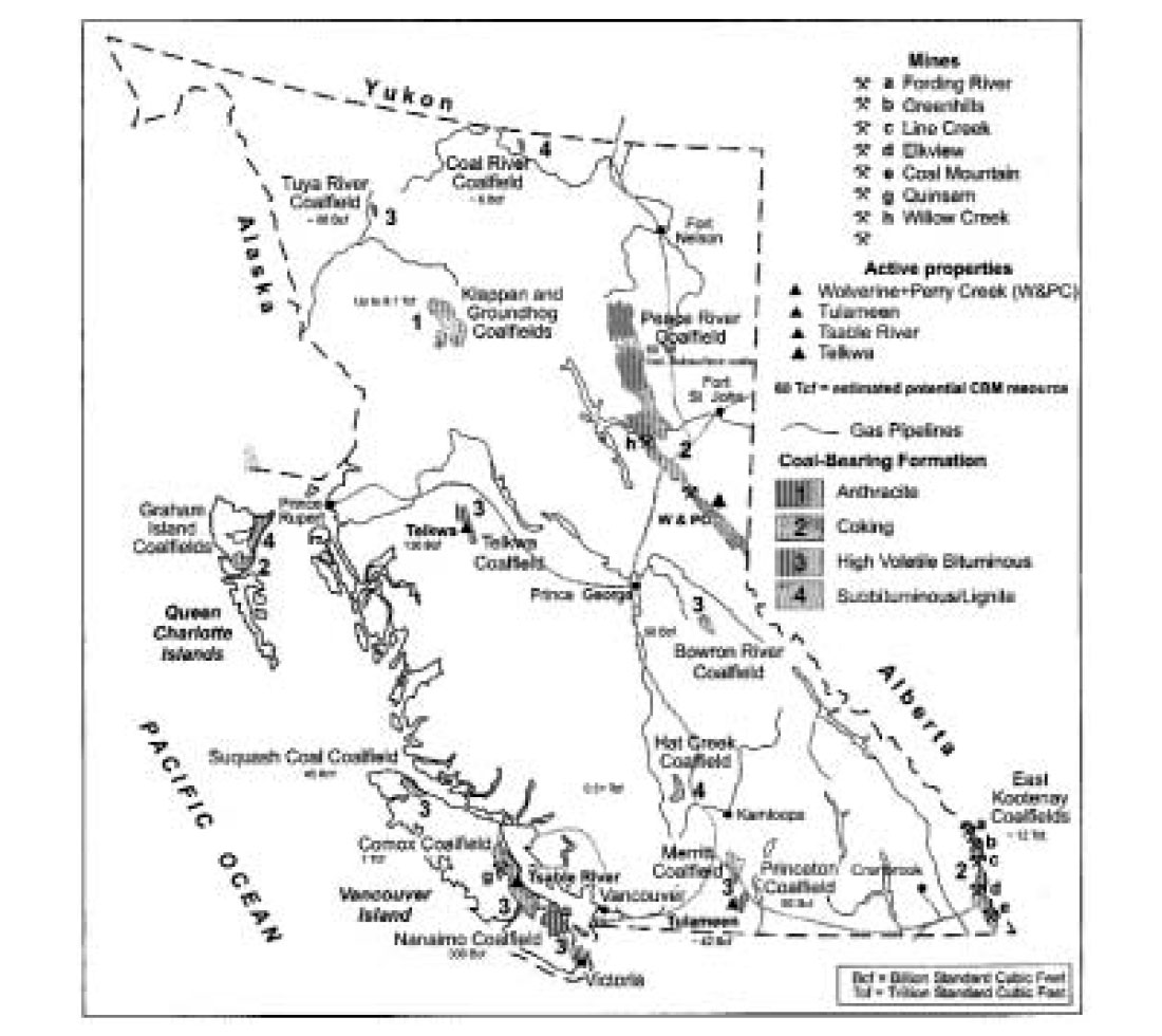
The coal is generally of medium-volatile bituminous rank. In the southeast of the province there are three coalfields (Crowsnest, Elk Valley and Flathead and in the northeast of the province the Peace River Coalfield. The Bowser Basin in northwestern is also in a fold and thrust belt. Other Cretaceous coalfields, such as those on Vancouver Island and at Telkwa, are less deformed and the main structures are vertical faults of various ages. There are also some significant Tertiary deposits in the province, the largest being Hat Creek. Generally these deposits are fault bounded and internally faulted, but folding is minimal. Coal rank is generally low and their CBM potential depends on the presence of biogenic methane.
In some coalfields, the coal-bearing formations form basins and the traditional limits of the coalfield define the area of interest for CBM exploration. In other coalfields the coal bearing formations dip to increasing depths and historical limits of the coalfield include only areas where surface or underground mining may be possible. In these cases the traditional coalfield limits do not outline all the area of interest for CBM exploration.
Published CBM resource assessments for southeast British Columbia indicate potential for more than 12 Tcf (Johnson and Smith, 1991) and for northwest British Columbia 8 Tcf (Ryan and Dawson, 1993). The author estimates a resource of about 60 Tcf for northeast B.C. and 0.3 to 1.6 Tcf. for Vancouver Island.
Individual Coal Fields
Peace River Coalfield
The Peace River coalfield (Figure 2) contains a number of coal bearing units that regionally dip to the east into the Western Canadian Sedimentary Basin. In order of decreasing age these are the Minnes Group, Gething Formation and Gates Formation. Younger formations also contain thin seams but are unlikely to be economic for CBM production. Upper Cretaceous and Tertiary formations with sufficient coal for CBM exploration outcrop in Alberta. The coal resource in the Peace River Coalfield to a depth of 2000 metres is estimated to be more than 160 billion tonnes. This is divided between the Gates (+10 billion tonnes) and Gething Formations (+120 billion tonnes).
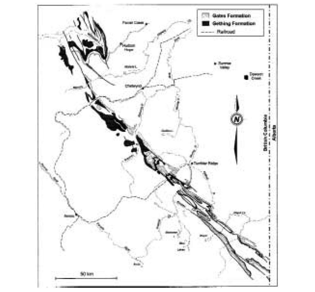
There are not a lot of data on the Gething Formation because it was not extensively explored. The formation underlies a large area of the Peace River coalfield, though it thins markedly at the south end of the field. The best coal development is between Williston Lake and Sukunka River to the south though the formation also contains coal at depth to the east towards Dawson Creek. South of Sukunka River the formation is thin and contains only a few seams. The Gates Formation contains coal from the Sukunka River south to the Saxon property near the Alberta border, although thicknesses appear to thin to the east at depth in the equivalent formation (Falher Formation).
Coal rank varies in both formations. In the Gething, rank is generally medium-volatile bituminous but decreases to the north and northeast toward Williston Lake. West of Sukunka River rank increases to low-volatile bituminous. The Gates is mainly medium-volatile bituminous but ranks on the western margin of the coalfield are lower. In both formations rank trends are somewhat complicated probably because of post thrusting coalification.
The CBM potential for the Northeast coalfield is enormous and has variously been calculated to be between 60 and 200 Tcf. In that there is no CBM production, one can only have moderate confidence in any estimate of the coal and CBM resource potential and should treat all estimates with extreme caution.
Existing CBM exploration in the Peace River Coalfield falls into a number of phases. First were estimates of desorbed gas contents of samples collected from shallow holes during coal exploration from 1975 to 1985. These data were collected as part of the appraisal of the underground coal mining potential of a number of properties. The data generally indicate low gas contents, but the data are old and were collected at shallow depths; they have little relevance to CBM resource evaluation. In 1996 Phillips Petroleum drilled 4 holes in the Monkman area and the data are summarized in Dawson et al. (2000). The holes intersected cumulative coal thicknesses averaging 20 metres at depths ranging from 1200 to 1550 metres. Gas contents ranged from 6 to 26 cc/g on an as received basis. Comparisons of desorption and adsorption data indicate that the seams are close to saturated; apparently, low permeabilities were encountered. This is not surprising considering the structure and depth. More recently, adsorption work done on samples from Gates coals (Lamberson and Bustin, 1992) and Gething Formation (Ryan and Lane, 2002) confirmed the high adsorption capacity of coals from these formations and documents the changes in capacity related to varying maceral compositions. Third, a number of exploration holes have been drilled in the last few years and most of the data from these holes are still confidential.
Southeast British Columbia Coalfields
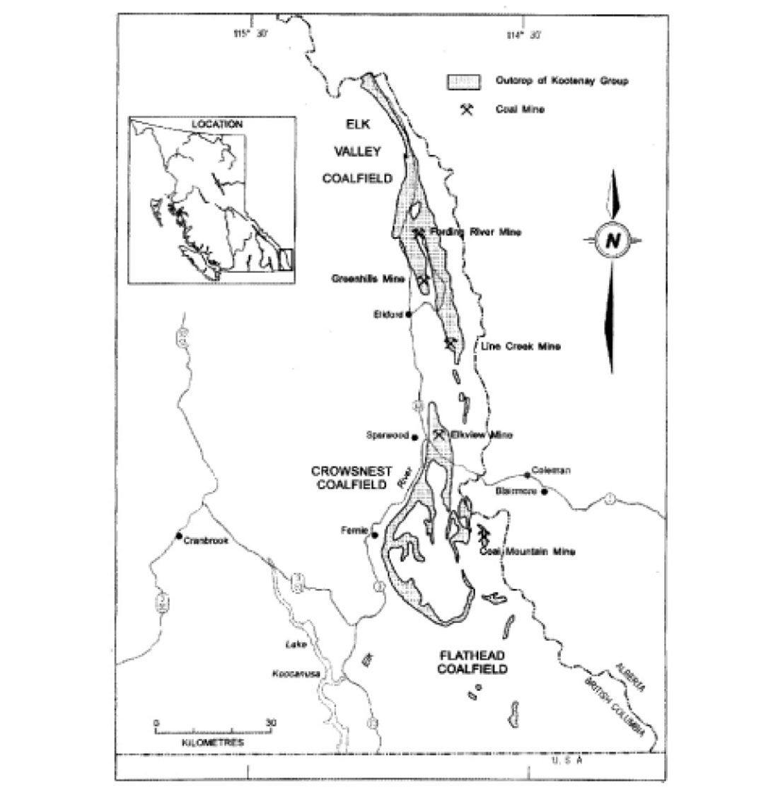
The southeast corner of British Columbia, often referred to as the East Kootenay region, contains the Elk Valley, Crowsnest and Flathead coalfields (Figure 3). Coal is contained in the Mist Mountain Formation of the Jurassic-Cretaceous Kootenay Group. The formation consists of a sequence of interbedded clastic sediments, ranging from mudstone to conglomerate, and coal. The formation averages 500 to 600 metres in thickness of which 8% to 12% is coal. The total coal resource in the three fields is estimated to be in excess of 50 billion tonnes.
Coal seams range in rank from low to high-volatile bituminous with the highest rank coals being exposed in the southwest part of the Crowsnest Coalfield. Generally coals at the base of the Mist Mountain Formation are medium-volatile while those in the upper part of the formation are high-volatile bituminous.
Elk Valley Coalfield
The coal resource to a depth of 1500 metres in the Elk Coalfield is estimated to be 19 billion tonnes (Johnson and Smith, 1991) with an estimated CBM resource potential of 7.7 Tcf. The Elk Valley Coalfield contains two north trending synclines separated by a major normal fault. The Bourgeau Thrust defines the west edge of the coalfield. In the three mines of the coalfield, coal seams in both synclines are folded and thrust faulted. Thicker coal seams are developed low in the section but they tend to host major thrusts, consequently some are extensively sheared.
There is a history of CBM exploration in the field. In 1981 CANMET desorbed samples from three holes over a depth range of 0 to 400 metres (Feng et al., 1981). They found that seams above 200 metres contained less than 2 cc/g of gas but below 200 metres gas contents ranged from 5 to 11 cc/g.
Fording Coal Limited drilled a single hole on the mine site in 1993. The hole, drilled to 533 metres depth, intersected 44 cumulative metres of coal between 300 to 520 metres depth. Gas contents ranged from about 3cc/g to 12.6 cc/g on an air-dried basis (arb), ash varied from 4% to 60%. Generally measurements indicated permeability in the range of 1 to 6 mD (Dawson et al., 2000) for the coal seams.
In 1991-1992 Norcen drilled four stratigraphic holes and a limited production test well in the northern part of the Elk Valley Coalfield. The holes were located on the east limb of a syncline where the Mist Mountain Formation is 650 metres thick and contains 19 seams with a cumulative thickness of 54 meters. Gas contents averaged 13.25 cc/g for coals deeper than 250 metres. There were indications of moderate CO2 contents in the gas desorbed from some samples. Suncor drilled a single hole in the core of the Alexander Creek syncline south of the Greenhills coal mine in 1998. Some of the seams had high CO2 concentrations and the company did not follow up on the exploration.
Since 2001, EnCana has drilled 17 holes in the Elk Valley Coalfield and at the moment is pumping on two pilots. Data from this exploration are still confidential.
Crowsnest Coalfield
The Crowsnest Coalfield has a coal resource of over 25 billion tonnes and a potential CBM resource of over 6 Tcf. The field includes the Elkview mine in the north and extends from the town of Sparwood to 20 kilometres south of the town of Fernie. The structure is that of a large basin that is cored by the younger Elk Formation and almost completely rimmed by outcrops of the older Mist Mountain Formation. Coal rank varies around the perimeter and down dip (Pearson and Grieve, 1985).
In the 1990 1991 period, three companies drilled a total of eight holes in the field. These holes were drilled in the southern part of the coalfield to test coal thicknesses and gas contents and did not test for production.
Mobil/Chevron drilled two holes. One penetrated 491 metres of Mist Mountain and intersected seven major coal zones with a cumulative coal thickness of 54.16 metres. Dawson et al.(2000) reported that the coal is fragmented or sheared. Gas contents ranged from 1.36 to 16.56 cc/g. Based on comparison of measured gas contents on a dry ash free (daf) basis to adsorption isotherm results samples, samples were saturated to between 25% and 63% of maximum gas capacity. Permeability appeared to be low to moderate.
Gulf Canada drilled two holes. Results were not encouraging mainly because the holes were drilled too close to coal subcrop. Saskoil drilled three holes. Two holes when combined intersected about 500 metres of the Mist Mountain Formation with about 63 metres of coal. The coal was moderately gassy with gas contents ranging from 0.4 cc/g to 11.9 cc/g.
Flathead Coalfield
Coal in the Flathead coalfield occurs in a number of outliers of the Mist Mountain Formation. The coal resource available for CBM exploration is about one billion tonnes (Johnson and Smith, 1991) with a potential CBM resource of 0.4 Tcf .
Bowser Basin
The Bowser Basin (Figure 1) is a remote region of rugged mountainous terrain in northern British Columbia. The area encompasses approximately 50 000 square kilometres and is bounded on the east by the Omineca and Cassiar mountains and on the west by the Coast Mountains. The Basin is defined by the outcrop extent of the Bowser Lake Group of Middle Jurassic to Lower Cretaceous age. The group contains a thick assemblage of at least 3500 metres of sediments that generally lack good stratigraphic markers or fossils and are moderately to intensely folded. It is a successor basin filled with a regressional sequence of marine to non-marine sediments that were deposited conformably on volcanics of the Hazelton Group.
Coal in the northern 10% of the Bowser Basin is found in the Jurassic Currier Formation in the Klappan coalfield and in its equivalent in the south the Prudential Formation in the Groundhog Coalfield. The Currier Formation crops out on all four sides of the Mt. Biernes Synclinorium, the most prominent regional structure in the coalfield. Potentially economic coal seams up to seven metres thick are present in the lower third of the Currier Formation. In the Mt Klappan area the formation is 900 to 950 metres thick and contains a cumulative coal thickness that ranges up to 53.62 metres. At Panorama Mountain to the south the stratigraphically equivalent interval of coal-bearing strata exceeds 1300 metres and contains up to twelve coal zones with a cumulative thickness of nine metres over an interval of 300 metres.
Fold styles in the basin range from open upright chevron to overturned and stacked recumbent. Folds often resemble asymmetric mega-kink bands with shallow and steep dipping limbs. The doubly plunging Mt. Biernes Synclinorium, which trends southwest for 85 kilometres, dominates the area between the Nass and Skeena rivers. The coal-bearing Currier Formation is exposed on its east and west limbs in the Nass and Skeena valleys and wraps around both ends of the trace. The depth to the Currier Formation below the axial trace of the synclinorium is probably between 1000 and 2000 metres. Coal-bearing rocks therefore underlie approximately 2000 square kilometres around the synclinorium. This comprises the area with CBM potential.
Coal rank ranges from semi-anthracite to meta-anthracite. And at these ranks and moderate temperatures coal can adsorb high concentrations of methane. Unfortunately at the temperature requires to make anthracite its ability to adsorb gas is very low. Consequently for anthracite at shallow depth to be saturated with adsorbed gas, it has to scavenge the gas during uplift. The gas may be thermogenic methane generated at depth or biogenic methane generated closer to surface. Whatever the origin of the gas it is impossible to predict the amount without drilling a hole and no CBM wells have been drilled in the Bowser basin.
The estimated potential coal resource in the Klappan and Groundhog coalfields is 37 billion tonnes and much of this is in the Currier Formation within the Biernes Synclinorium. This is a speculative number and should be used only as an indication of the order of magnitude of the coal resource available for CBM exploration. The estimated potential CBM of 8 Tcf is calculated using a conservative gas content value of 5cc/g. The resource assessment is restricted to the area of Currier Formation outcrop within the coalfields. Coal outcrops outside this area but usually in thin and widely scattered seams.
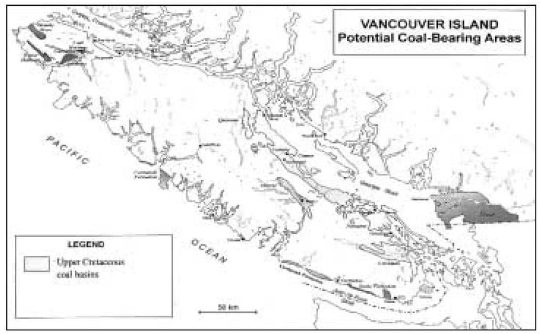
Vancouver Island coalfields
Coal resources of the coastal area of British Columbia are restricted to Vancouver Island, the Queen Charlotte Islands and some of the Gulf Islands (Figure 4). Coal rank ranges from anthracite to lignite, with most being high-volatile bituminous. Ages range from Jurassic to Tertiary though most is found in the Nanaimo Group, which is of Upper Cretaceous age. The major Upper Cretaceous coalfields on Vancouver Island are the Comox and Nanaimo fields. There are a number of smaller coalfields of the same age on the Island with limited CBM potential. These are the Suquash, Cowichan and Alberni coalfields. The Quatsino coalfield, also with low potential, is of Lower Cretaceous age.
North of Vancouver Island, coal-bearing rocks on the Queen Charlotte Islands of Jura-Cretaceous and Tertiary ages generally have low CBM potential.
Vancouver Island coals are generally less deformed than coals in southeast and northeast British Columbia and in the Bowser Basin. There was some early CBM exploration on the Island between 1984 and 1985 when Novacorp drilled 14 holes. In the early 1980’s Gulf and British Petroleum also drilled deep holes though not specifically for CBM.
There are at least two coal bearing formations within the Nanaimo Group. The first is the basal Comox Formation, which is the source of coal in the Comox Coalfield. This coalfield is centered on the Town of Courtenay and includes the Quinsam mine, which is the only operating coal mine on the island. The southern part of the coalfield has good CBM potential. The Comox Formation is overlain by marine sediments of the Trent River Formation in the Comox Coalfield or the Haslam Formation in the Nanaimo Coalfield. The Haslam Formation is overlain by the Extension and Protection formations, which host the coal seams in the Nanaimo Coalfield, which is centered on the town of Nanaimo.
The CBM potential of the Nanaimo and parts of the Comox Coalfield extend eastward under Georgia Strait to the east and beyond the surface expression of the fields. Estimates of resource potential for these coalfields may include undersea CBM, which at the moment cannot be legally recovered. Published estimates of the CBM resource potential for Vancouver Island range from 230 bcf (6.5million cubic metres) Proudlock (1990) to 1 Tcf (Energy Market Update, 1992). The first number is not broken down in terms of the different coal basins, gas contents or coal tonnages. Proudlock (1990) used an average gas content of 9cc/g (288 scf/ton) to calculate his value. Estimates of the coal resources on Vancouver Island range from a low of 800 mt to a high of 6920 mt and average 3850 mt.
Nanaimo Coalfield
The Nanaimo Coalfield covers about 400 square kilometres and based on previous mining, which from 1849 to about 1950 extracted over 50 million tonnes from the Extension and Protection formations, has a remaining coal resource estimated to range from 10 mt to 100 mt. Coal rank is high-volatile A bituminous and the coal occurs in three non overlapping seams, being the Douglas, Wellington and Newcastle seams. Coalbed methane opportunities in the Nanaimo Coalfield are probably limited because of past underground mining of the Douglas and Wellington seams. There may however be opportunities to retrieve CBM from the underground mine workings. Unfortunately these are now under residential areas of Nanaimo.
Recent work indicates there is also coal in the Comox Formation within the Nanaimo Coalfield and there may be some CBM potential in this deeper formation. Cumulative coal thickness in the Douglas coal zone ranges from 3 to 10 metres (Cathyl-Bickford et al., 1992). A single intersection in the Comox Formation was 3.0 metres thick. Most of the CBM potential will be in the eastward extension of the Douglas seam and the deeper Comox coals if they are extensive. The potential CBM resource of the Nanaimo Coalfield is estimated to be in the range of 0.4 Tcf.
Comox Coalfield
The Comox Coalfield extends from 20 kilometres north of Nanaimo to Campbell River and covers about 1100 square kilometres. Coal rank ranges from high-volatile B bituminous to high-volatile Abituminous and tends to increase to the south (Kenyon and Bickford, 1989). Coal in the coalfield is restricted to the Comox Formation. The coalfield is divided into a number of sub basins for the purposes of estimating CBM resources.
In the north some desorption data was collected from holes drilled on the Quinsam mine site where the rank is of high-volatile B bituminous and cumulative coal thickness is about 7.5 metres. Ryan and Dawson (1994) collected seven samples from two shallow holes. Gas content of samples collected from depths ranging from 100 to 150 metres ranged from 0.44 cc/g to 1.632 cc/g on a dry ash free (daf) basis. The sub-basin covers an area of 155.4 square kilometres and is generally fault bounded. The area of the coalfield around Campbell River is about 300 square kilometers and the potential CBM resource is about 130 bcf.
South of Campbell River and north of Courtenay, the coalfield covers an area of about 250 square kilometers, and has a potential CBM resource of about 130 bcf. There has not been much surface exploration or drilling in this area and there is not much information on coal thicknesses.
The area of the Comox Coalfield around the town of Courtenay covers about 200 square kilometers and is prospective for CBM. There is a history of mining in the area and gas emission data from the mines indicates gas contents ranging from 7.8 to 11.7 cc/g at depths that average 250 metres. The Comox Formation contains four major seams with a cumulative thickness ranging from 2 to 8 metres. Three CBM exploration holes and a natural gas well were drilled in the Courtenay area in 2000 and 2001. Twelve samples for desorption were collected from the three CBM holes and the results (Ryan, 2002) indicate gas contents ranging from 2.2 to 7.4 cc/gm on an as received basis (or 3.6 to 12 cc/g daf basis) for samples collected over a depth range of 238 to 255 metres.
The area of the Comox Coalfield south of Courtenay covers about 330 square kilometers of which about 160 square kilometers is within the Tsable River area which is prospective for CBM. Coal in the area, which has a rank of high-volatile A bituminous, is in the Comox Formation and cumulative coal thickness is about 8.3 metres contained in up to four seams. Gas was reported in a few deep holes drilled in the early 1900s (Cathyl-Bickford, 1991). In 1996 (Ryan, 1997) desorbed 13 samples covering depths from 126 to 376 metres. Gas contents on an as-received basis range from 1.6 to 5.5 cc/g. The gas contents increase consistently with depth but samples were under saturated. These concentrations are high enough to make the area attractive for its potential CBM resource. Resource calculations for part of the southern end of the Comox basin indicate a potential of about 0.45 Tcf.
South of Tsable River in the Qualicum area there is little information on coal distribution. Dolmage Campbell and Associated, (1975) could find no record of coal occurrences south of Tsable River in the Comox Basin and considered the coal potential of the sub-basin to be very low. Cathyl-Bickford and Hoffman (1991) report two coal occurrences with seams that are 3.26 and 1.99 metres thick, including rock splits. The CBM potential for the Qualicum sub-Basin is considered to be low and no estimate is made.
Suquash Coalfield
The basin covers an area of 120 square kilometers of Nanaimo Group rocks. Coal rank is high-volatile B to A bituminous (Kenyon, 1991). Beds dip at 5 to 10° to the northeast. The coal bearing section is at least 360 metres thick. Coal is in the upper 200 metres of the section in approximately nine zones that contain about four metres of coal in total. If the basin is underlain by, on average, two metres of coal, then the coal resource would be about 300 mt. If the coal bearing stratigraphy extends to the northeast under Malcolm Island, it provides a basin area of 300 square kilometres and a potentially larger coal resource. If a coal resource of 300 mt is assumed then the estimated potential CBM resource is 45 Bcf.
Telkwa Coalfield
The Telkwa Coalfield in central British Columbia extends for about 50 kilometres along the Bulkley River from north of the town of Smithers to south of the village of Telkwa. Two coal bearing units separated by a marine mudstone unit are contained in the Lower Cretaceous Skeena Group. The upper unit contains at least eight seams with cumulative coal thickness up to 14 metres. The lower unit contains a single coal zone with cumulative coal thickness up to seven metres. Coal rank ranges from high-volatile bituminous Ato anthracite, though most of the coal is in the range high-volatile A to medium-volatile bituminous. The coalfield has a potential resource of approximately 850 million tonnes.
In 1990 Ryan and Dawson (1994) desorbed five samples from two rotary drill holes. Gas contents ranged from 3.75 to 4.49 cc/g on a daf basis and did not increase with depth. Generally Telkwa coals are hard and well cleated. Seams have moderate to good permeability and at depths ranging from 29 to 158 metres values range from 0.5 to 50 milliDarcies. Sections of mudstone, siltstone and sandstone interburden varying in thickness from 14 to 27 metres and at depths of less than 200 metres, have permeabilities ranging from 13 to 35 milliDarcies. Interburden permeability is on average greater than that of the coal.
The estimated total CBM resource of the Telkwa Coalfield is 0.13 Tcf. The Telkwa coalfield is close to the towns of Smithers and Telkwa, which could offer ready markets for small quantities of gas. The Pacific Northern Gas Limited natural gas pipeline crosses the Telkwa Coalfield south of Telkwa. This pipeline connects Prince Rupert and Kitimat with pipelines from northeast and southwest B.C.
Tertiary Coal Deposits
Tertiary sediments survive in many major watersheds in British Columbia. The sediments, which are generally not well consolidated, are poorly exposed and their subcrop extent is often arbitrarily delineated by adjacent high ground underlain by pre-Tertiary rocks. Many of these Tertiary basins contain coal, varying in rank from lignite to medium-volatile bituminous. Seam thicknesses vary from a few centimetres to many metres. Often the seams are contained in much thicker carbonaceous zones that increase the CBM potential.
Hat Creek
The Hat Creek Basin, which is located 20 kilometres west of Cache Creek, is one of the thickest Tertiary coal deposits in the world and contains an enormous amount of low rank coal concentrated in a small area. It consists of two poorly exposed coal deposits. The northern, Number 1, deposit covers 3.5 square kilometres and the larger, Number 2, deposit, 3 kilometres to the south, covers 25 square kilometres. The Tertiary section in the area is 1500 metres thick and is divided into three units. The middle Hat Creek Formation is about 500 metres thick of which about 65% is coal (Church, 1977).
The number 1 deposit has been explored as a potential open pit mine. Reserves in this deposit to a depth of 200 metres are over 500 mt of lignite A to sub-bituminous C coal. The deposit comprises two south plunging half synclines truncated on the southeast end by northeast trending gravity faults (Graham, 1989). Dips average about 25°. The number 2 deposit occurs within a graben that is bounded by north trending normal faults. The resource of the No 2 deposit to a depth of 460 metres is estimated to be over 2 billion tonnes (Papic et. al., 1977). Estimates of the coal resource in the whole basin exceed 10 billion tonnes.
The low rank of the coal means the amount of thermogenic methane generated will be small to nil and the ability of the coal to adsorb methane will also be low. However low rank coals can have high meso porosities compared to higher rank coals (Bustin, 1999) and therefore can retain moderate amounts of free gas, much of which would likely be of biogenic origin. Even if gas contents are only of 1 to 3 cc/g (30 to 100 scf/ton) because of the large coal tonnages there could still be a sizable CBM resource at Hat Creek of over 0.5 Tcf concentrated in a small area.
Princeton
The Princeton Basin covers an area of about 170 square kilometers and is approximately 24 kilometres long and 4 to 7 kilometres wide. The Tertiary Basin is composed of a number of northwest trending synclines with faults defining the western and eastern edges of the basin. Most of the coal resource, which is high-volatile B bituminous in rank, appears to be in the southern part of the basin south of the town of Princeton. In this area there are four major coal zones, numbered from one at the top to four at the base of the section in about 530 metres of section. The lowest zone (Number 4) ranges in thickness from 10 to 50 metres and is described as mainly dirty coal with a clean coal seam up to 2 metres thick near the top. The next (number 3 zone) is 140 metres higher in the section and is about 30 metres thick. It is reported to contain up to two workable seams. The number 2 zone contains 7.5 metres of coal in a 26 metres section and is 200 metres above the number 3 zone. The number 1 zone is 100 metres above the number 2 zone and contains from 2 to 3 metres of coal.
In 2002, 3 coal exploration holes were drilled in the Princeton Basin and based on encouraging results the CBM tenure was obtained by Petrobank. Since then the company has conducted a seismic survey and at the moment plans to drill a multi hole pilot in late 2003 or 2004. Based on the data available, the company estimates that there could be 100 bcf of recoverable CBM in the basin.
Tulameen
The Tulameen basin, which is 20 kilometres northwest of Princeton, forms an elliptical sedimentary basin 5.4 by 3.6 kilometres in size, that contains two well-developed thick coal seams of high-volatile B bituminous rank. The area underlain by coal is about 10 square kilometers.
The stratigraphy in the basin is subdivided into five units that consist of a lower conformable volcanic unit, three sedimentary units and an uppermost non conformable volcanic unit. The middle sedimentary unit, which is about 130 metres thick, contains shales and 2 major coal seams. The upper sedimentary unit consists of conglomerates sandstones and is at least 400 metres thick. The rocks are folded into a broad syncline. The coal bearing section contains two coal seams though they tend to be very dirty with partings of shale and bentonite. The lower seam is seven to eight metres thick and the upper seam 15 to 21 meters thick. The seams are thought to underlie the whole basin.
Underground mining carried out in the area began in 1919 and ended in 1940. The mines extracted about two million tonnes. Renewed interest in the 1950s led to surface mining that extracted a further 150 000 tonnes of coal. At present a company has started mining on a small scale and is trucking coal to local markets. The company has also expressed interest in the CBM potential. Based on the synclinal form of the coal horizon there is a potential coal resource of at least 300 mt And a potential CBM resource of 50 bcf in the basin.
Merritt Coalfield
The Merritt Coalfield underlies the town of Merritt and adjacent areas. The main area, which is under and south of Merritt covers about 80 square kilometers. A smaller area to the east is about 25 square kilometres in size and has not been extensively explored. The Merritt area, which contains high-volatile C to A bituminous coal, was explored in 1945 and 1960 and about 10 mt of underground mineable reserves were outlined. There appear to be seven seams with a cumulative coal thickness of 22 metres in a 250-metre section. Overall, the Merritt Coalfield has not been extensively explored but much of the area underlies the town of Merritt and some of the areas are overlain by relatively recent (500 000 years) volcanic flows. It is difficult to estimate the resource in the area but if a coal thickness of 10 metres extends through the whole coalfield, then there could be over 800 mt and a moderate CBM resource of over 50 bcf under the town of Merritt. A company has acquired freehold coal rights in the area and hopes to drill coal exploration holes that will provide some information on the CBM potential.
Tuya River
The Tuya River Basin is located between the communities of Dease Lake and Telegraph Creek in northwestern British Columbia. The basin is potentially quite large, yet it has escaped detailed study. The simplest interpretation of the basin is that it has the form of an open, northerly plunging syncline with some faulting and smaller scale folds. Limits of the basin are poorly defined and in places recent volcanics overlie the sediments; however, it is estimated that the basin covers approximately 150 square kilometers.
The stratigraphic succession contains two units of Eocene age. The lower unit is 200 to 300 metres thick and contains a single coal zone The zone is about 100 metres thick and includes from 5 to 30 metres of coal. The upper unit, which is at least 300 metres thick, is composed of volcanic-pebble conglomerate, sandstones, and volcanic rocks. The coal, which has a rank of sub-bituminous B to high-volatile bituminous A, is hard well cleated and contains a moderate amount of resin.
The basin contains about 400 million tonnes of coal within 1600 metres of surface. A moderate CBM resource of up to 40 Bcf may exist in the basin (Ryan, 1991). Most of this resource would be biogenic methane because of the low rank.
Bowron River
The Bowron River graben, which is 50 kilometres east of Prince George, is 2.5 kilometres wide and 15 kilometres long. The lower 85 meters of the more than 700 metre thick sedimentary section is coal bearing. The coal section dips at 20° to 60° to the northeast and contains at least 3 seams with a cumulative thickness of 8.5 metres. The coal, which is high-volatile B bituminous in rank, is characterized by a high resin content (8%). Considering only the lower seam, Matherson and Sadre (1991) estimated a potential resource of 400 mt down to a depth of 1200 metres. Any CBM potential will depend on the presence of biogenic methane though the presence of amber may help initiate generation of thermogenic methane at a lower rank. There could be a CBM resource of about 40 bcf.
Coal River
Coal River flows south joining the Liard River approximately 150 kilometres east of the town of Watson Lake. Lignite outcrops about 10 kilometres up the river from where it crosses the Alaska Highway (Ryan (1996).
Generally Tertiary outcrops are restricted to the riverbanks and trees, swamp and a burn zone cover the rest of the area. The area around the river is marked by large crescent shaped slumps, presumably where younger sediments have slid on a clay layer, which overlies the coal. Exposures of a single lignite seam with shallow dips outcrop along the river. The full thickness of the seam is not known but observed thicknesses range up to over eight metres. The lignite is cleated with two sets generally developed.
The Coal River Basin has a possible area of about 35 square kilometres. If the lignite seam is on average five metres thick then the preliminary resource estimate is about 100 million tonnes of lignite. The rank is too low for generation of thermogenic methane. However the lignite may contain reasonable quantities of biogenic methane. A lignite resource of about 100 mt could contain a CBM resource of about 6 Bcf depending on its ability to retain free gas and its ability to adsorb gas.
Summary
There is a large coal resource in British Columbia, which is estimated to contain a CBM resource in the range of 90 Tcf. This resource is contained in coals from three tectonic environments. Much of the coal in the province is in the foothills of the Rocky Mountains where it has experienced a moderate amount of deformation that affects permeability and adds to production difficulties. In this environment careful selection of drill targets and possibly novel completion techniques may be required to overcome decreased permeability.
The Klappan Groundhog anthracite deposit in the Bowser Basin could contain large quantities of CBM. The area is isolated from infrastructure and experience with producing CBM from anthracite is limited, however is an intriguing exploration target for the future.
Cretaceous coals on Vancouver Island and at Telkwa have experienced much less deformation and are structurally similar to CBM basins in the USA. The Tertiary CBM deposits occupy grabens often in extensional environments. Coals are well cleated and generally of low rank. By far the largest Tertiary deposit is Hat Creek, which with a coal section that exceeds 500 metres is one of the thickest coal deposits in the world.
The gas is in the coal and sooner or later the forceful combination of economic incentive and human ingenuity will get it out.


Join the Conversation
Interested in starting, or contributing to a conversation about an article or issue of the RECORDER? Join our CSEG LinkedIn Group.
Share This Article