Introduction
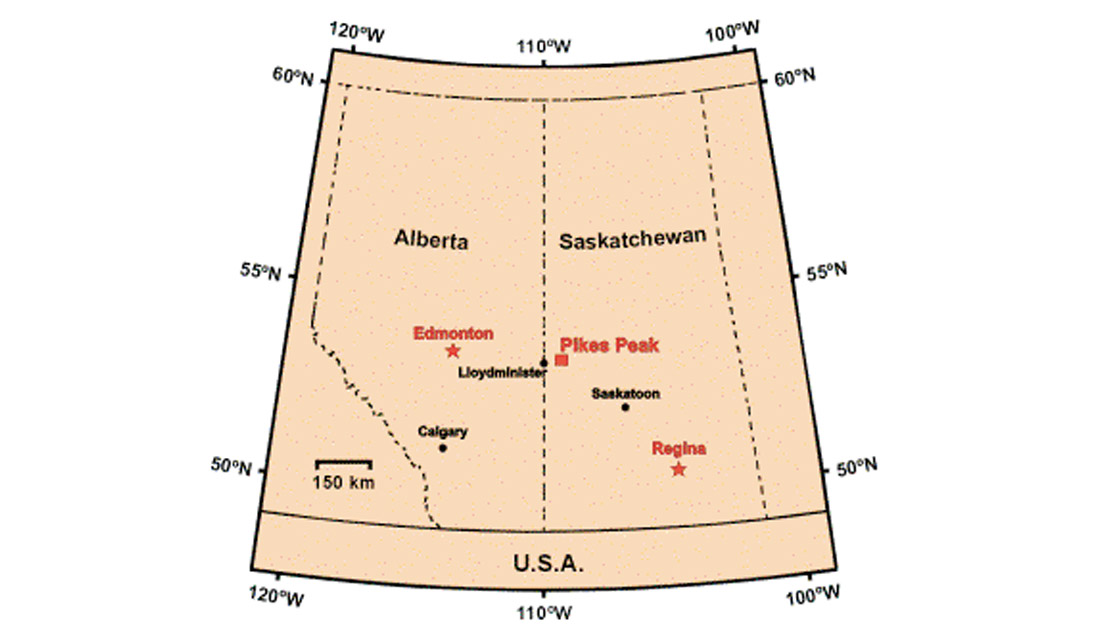
The CREWES Project and AOSTRA in collaboration with Husky Energy Inc. conducted a detailed study of Husky’s Pikes Peak heavy oil field near Lloydminster, Saskatchewan (Figure 1). The target of interest in this area is the oil-saturated Waseca sand at a depth of about 500 m. The principal objective of the study (and its surveys) was to develop new seismic technologies for imaging shallow heavy oil reservoirs. As part of this study, a unique experimental “lake-bottom seismic cable” survey was acquired in September, 2000. The lake-bottom cable (LBC) was Schlumberger Canada’s five-level, VSP tool. This 60 m long downhole tool had 3-C receivers separated by 15 m with a flexible cable between sensor levels. The basic idea of the experiment was to determine if coherent seismic energy could be recorded by the seismic sensors laid on the bottom of a lake (actually a 1 m deep slough) in the area. If successful, this type of recording could assist land-seismic exploration in summer months and might be beneficial to marine surveying using a VSP tool as an ocean-bottom cable (OBC). Other investigators (personal communications from Brad Torry of Arcis Corp. and Bill Goodway of PanCanadian Petroleum Ltd.) have been successful in using hydrophones and planted-marsh phones in lakes, however we are not aware of any other measurements of geophones towed across a lake bottom.
Acquisition
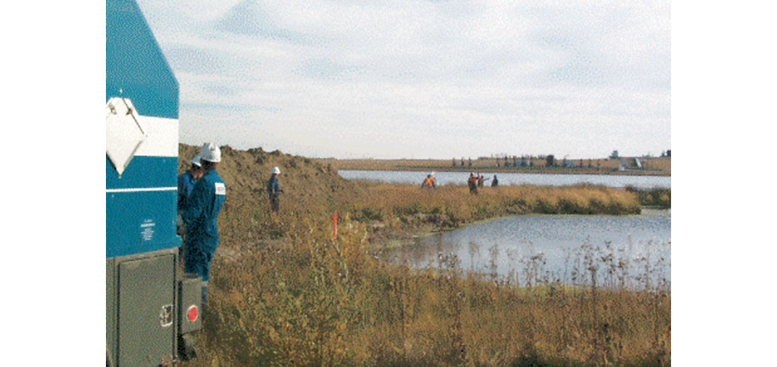
To conduct the lake-bottom survey, we first floated and pulled the wireline from the VSP recording truck across the slough (Figure 2). At the far side of the slough, the manual towing effort of the wireline was assisted by an extension rope and an all-terrain vehicle. When the wireline head was across the slough, we assembled and attached the 60 m long VSP tool. The Schlumberger VSP (ASI) tool, now deployed horizontally, acted as a five-station, lake-bottom geophone cable.
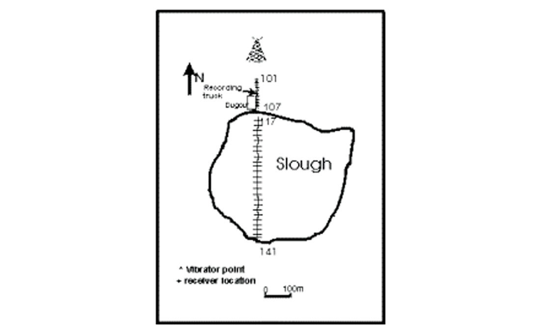
The truck then winched the wireline and tool back across the slough – stopping at 29 tool locations. A vibrator walked away from the slough edge to give 5 source positions (Figure 3) for each cable position.
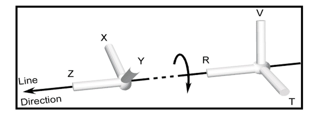
The normally “vertical” or “z channel” elements of the VSP tool were lying horizontally while the originally “horizontal” elements were in the vertical plane orthogonal to the cable direction on the lake bottom. The cable positions were offset from 49m to 409m from the recording truck. Five other in-fill shots were taken at the first cable position. We moved the tool 75 m after each shot group to provide a line with receiver spacing of 15 m.
Data Processing
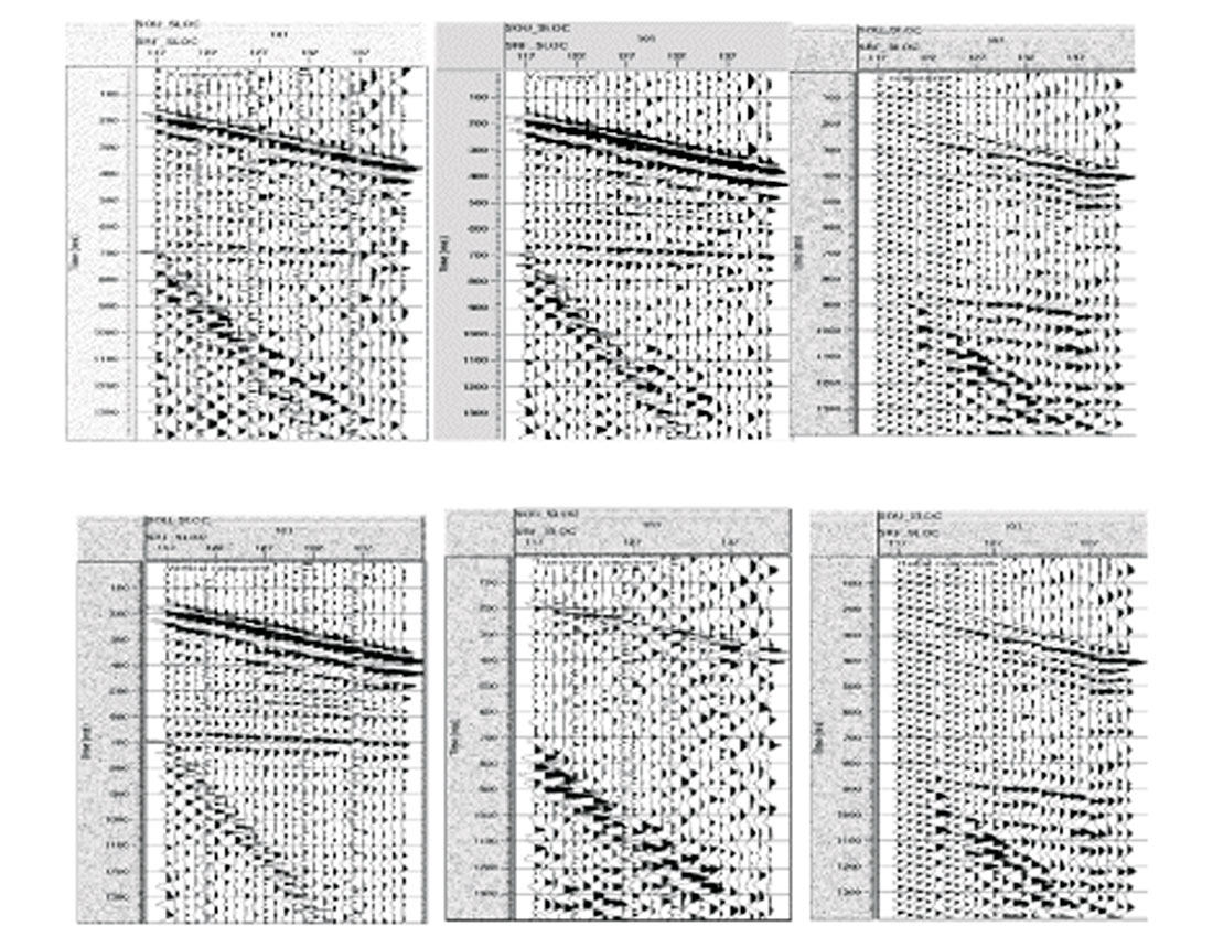
The data were first vertically stacked. The total dataset included the 10 vibrator positions: 5 shot locations had 25 geophone receiving locations, while the other 5 shots had only 5 geophone locations (one cable position). As mentioned previously, the data on the “z” channel from the VSP tool are now considered to be in the in-line or radial direction. In addition, the original horizontal or “x” and “y” channels are now in a vertical plane. We would like to have acquired the data with a true vertical geophone, but this is not possible as the wireline and tool rotate as they are winched in to the truck. So, we rotate the data by projecting the x and y channels onto a maximum P-wave power direction that we assume to be vertical (Figure 4). One of the shot gathers, with 25 three-component receivers, is shown in Figure 5 before and after rotation. The spectrum of the vertical component shows coherent energy up to 60 Hz.
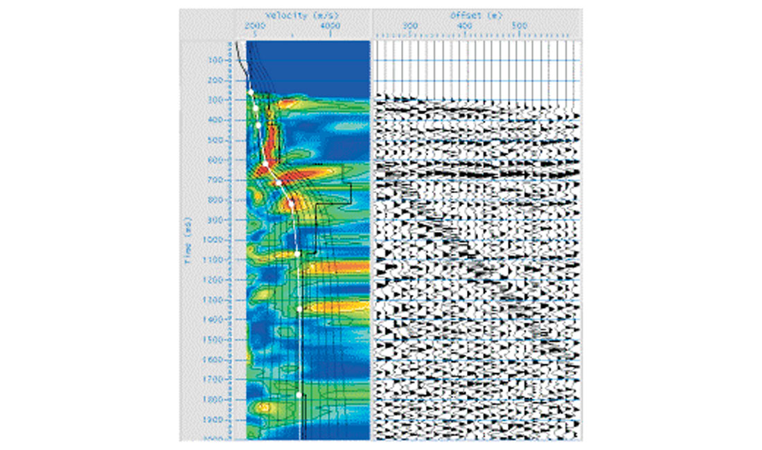
We use the new, oriented vertical component for processing the P-wave data set. A hand-static solution was applied because the short offset range did not allow other types of analysis. The CDP fold was very low (1-7 fold), so we performed the velocity analysis on the shot gathers (Figure 6). While not ideal, this was justified by the flat geology of the area. We then proceeded to a stacked section.
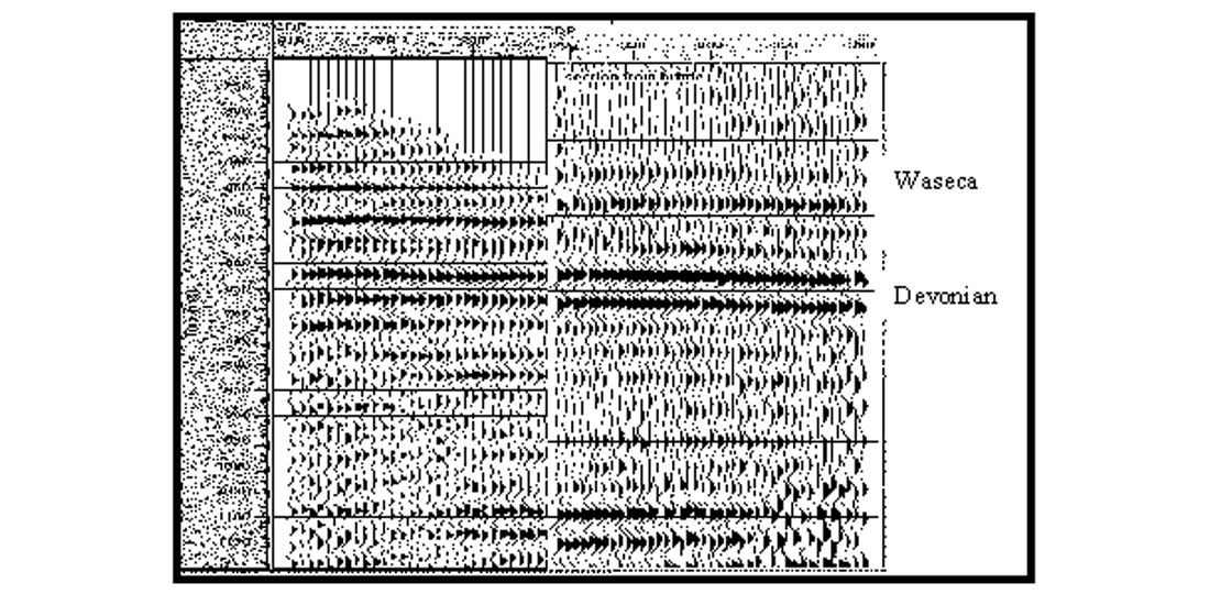
This LBC stack is compared to a bandpass-filtered version from our winter survey (Figure 7). The frequency spectrum of the winter survey (with frozen-in geophones) showed a very high frequency content (up to 150 Hz). However, to compare with the LBC data, the winter section was bandpass filtered (6-11-30-40 Hz). This band-limited section correlates fairly well with our lake-bottom seismic section. While the LBC stacked section is clearly lower frequency, we were surprised at its quality considering all of its limitations. The frequency content may be compromised for a number of reasons including poor source coupling (the vibrator was operating in a muddy/unconsolidated area), the receivers were just laid on the slough bottom, a water-surface ghost could attenuate the received data, and very low fold.
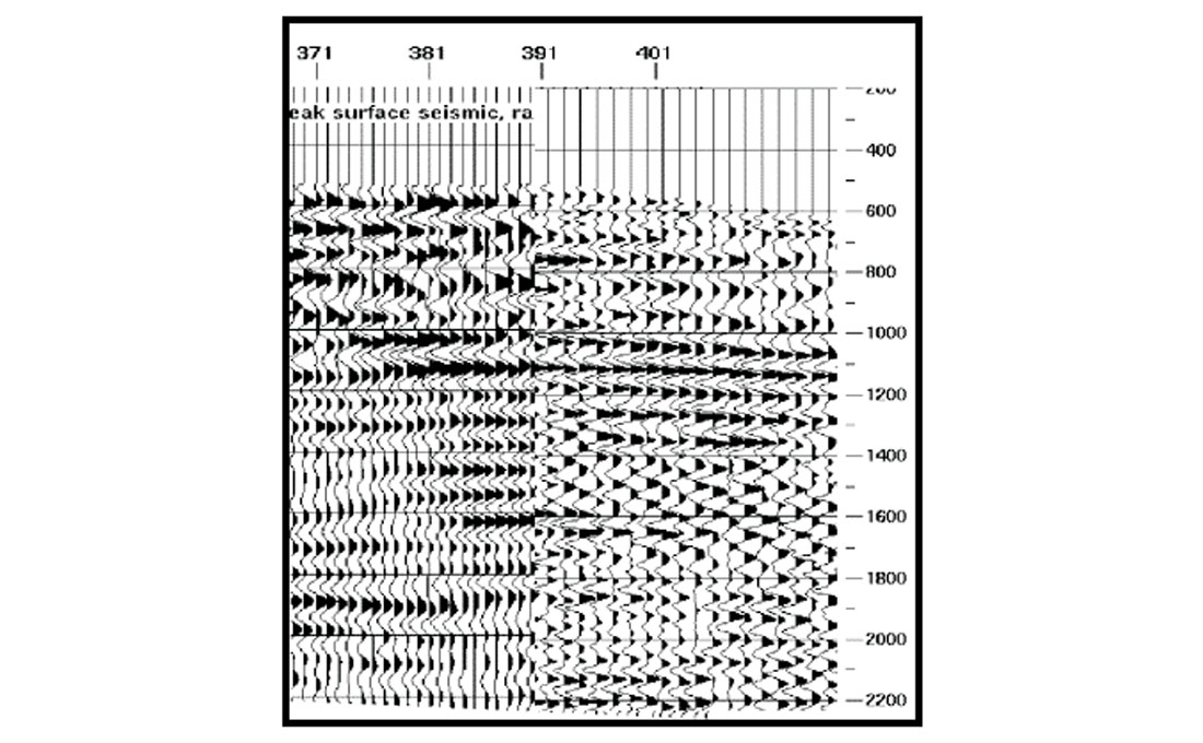
We also processed the radial channel for converted waves (P- to- S reflections). Using the final P-wave velocities and source statics, hand receiver statics, PS spherical divergence correction, and a Vp/Vs value of 3.0, we constructed a depth-variant P-S section (Figure 8). This section is also compared to the P-S results from the 3-C surface seismic line shot in winter (the winter seismic had a 3-7-25-30 Hz bandpass filter applied). While the correlation is less compelling in the P-S case, we can still interpret a relationship between the sections.
Summary
We conducted a “lake-bottom cable” seismic experiment by deploying a 3-C VSP tool in a shallow lake in the Pikes Peak heavy oilfield, Saskatchewan. By winching in the tool from the wireline truck, a small line of seismic data was acquired. Coherent seismic reflections, both PP and PS, were recorded and processed. While the resultant seismic section did not contain as high frequencies as a previously recorded surface seismic line (in winter), we were able to reconstruct an interpretable sections. This technique bears promise for lake surveying in the summer as well as marine applications.

Acknowledgements
We express our appreciation to the CREWES Project sponsors for supporting this effort as well as Husky Energy Inc. for providing much assistance in logistics and field support. This work was partially funded by AOSTRA (Project #1296) and we are grateful to the Government of Alberta for its support. Dr. Larry Lines very capably co-ordinated the Pikes Peak Project. In addition, we would like to thank the Schlumberger Canada field engineers, Rick Jacobs, Brad Jordan, Lyes Oualis, and Kelly Provost who patiently acquired this unusual data set (we don’t want to know what they were really thinking as we pulled their wireline across the slough). Mike Jones of Schlumberger also supported this work in its formative stages. Katherine Brittle and Ayon Dey, formerly with CREWES at the University of Calgary, ably assisted with the field work. Thanks to Ms. Brittle for providing the winter 2000 P-wave section.


Join the Conversation
Interested in starting, or contributing to a conversation about an article or issue of the RECORDER? Join our CSEG LinkedIn Group.
Share This Article