Remote sensing is the science of acquiring, processing and interpreting data about the Earth's surface that is recorded by sensors on satellites or aircraft. Geoscience applications of remote sensing include the mapping of surficial deposits/bedrock, lithology, structures and structural trends, sedimentation and geohazards, sand and gravel exploration/ exploitation, mineral and hydrocarbon exploration, environmental geology, geobotany and planetary mapping.
Remote sensing techniques utilize several regions of the electromagnetic spectrum: (1) the ultraviolet portion of the spectrum, which has the shortest wavelengths practical for remote sensing, (2) the visible region (0.4 – 0.7 μm), which is divided into blue, red and green bands, (3) the infrared (0.7 – 100 μm) and (4) the microwave region (0.1 – 100 cm). The infrared (IR) part of the spectrum is divided into the reflected IR (0.7 – 3 μm) and thermal IR (3 – 100 μm). However, thermal sensing is usually restricted to the bands 3 – 5 μm and 8 – 14 μm because of absorption of energy by atmospheric gases. Data from the visible and IR spectra are acquired in a passive mode by sensors that record energy reflected or radiating from the Earth while reflected energy in the microwave region is activated by incident radar transmitted from the satellite. Thermal sensors detect emitted thermal radiation with sensitive photo detectors and the spatial resolution is usually fairly coarse relative to that of visible and reflected infrared data. A typical thermal image has spatial resolution of 30 m while resolution of <1 m has been achieved on images in the visible and reflected IR acquired from space. Thermal imagery can be acquired during the day or night and is used for a variety of applications such as military reconnaissance, disaster management and heat loss monitoring.
Many electronic remote sensors acquire data using scanning systems, which employ a sensor with a narrow field of view that sweeps over the terrain to build up and produce a two-dimensional image of the surface. The most commonly used scanning system is a multispectral scanner (MSS), which collects data over a variety of different wavelength ranges, such as the thermal IR, visible and reflected IR portions of the spectrum. The Landsat satellites have carried an MSS. MOMS (Modular Optico-electronic Multispectral Scanner) is a recent development that uses charge-coupled devices as the detectors, unlike the MMS and TM (Thematic Mapper) scanners, which use moving parts that are subject to wear and failure.
Other remote sensing techniques are also used but are less popular:
Video cameras provide a useful means of acquiring timely and inexpensive data and vocally annotated imagery although the images are coarser in spatial resolution than traditional photography or digital imaging. Applications with these requirements include natural disaster management, crop and disease assessment, environmental hazard control and police surveillance. Cameras used for video recording measure radiation in the visible, near infrared and sometimes mid-infrared portions of the EM spectrum.
Forward Looking InfraRed (FLIR) systems operate in a similar manner to across-track thermal imaging sensors but provide an oblique rather than nadir perspective of the Earth's surface. Typically positioned on aircraft or helicopters, and imaging the area ahead of the platform, FLIR systems provide relatively high spatial resolution imaging that can be used for military applications, search and rescue operations, law enforcement and forest fire monitoring.
Laser fluorosensors illuminate the target with a specific wavelength of radiation and are capable of detecting multiple wavelengths of fluoresced radiation. This technology has been proven for ocean applications such as chlorophyll mapping and pollutant detection, particularly for naturally occurring and accidental oil slicks.
Lidar is an acronym for LIght Detection And Ranging, an active imaging technology very similar to RADAR. Pulses of laser light are emitted from the sensor and the reflected energy is recorded. Lidar is used effectively for measuring heights of features such as forest canopies and the depth of water bodies. Lidar is also used in atmospheric studies to examine the particle content of various layers of the Earth's atmosphere, acquire air density readings and monitor air currents.
RADAR stands for RAdio Detection And Ranging. RADAR systems provide their own source of electromagnetic energy in a series of pulses from an antenna targeted obliquely to the surface perpendicular to the direction of motion. The energy ranges in wavelength from a few centimetres to a few tens of centimetres. The backscattered microwave radiation is detected, measured and timed. By recording the range and magnitude of the energy reflected from all targets as the system passes by, a two-dimensional image of the surface can be produced. Images can be acquired day or night and, since microwave energy is able to penetrate through clouds and most rain, it is an all-weather sensor. The intensity of the reflected energy is governed by the dielectric constant of the surface and its roughness and topography. The Canadian Centre for Remote Sensing (CCRS) operates Radarsat, which was launched in 1994.
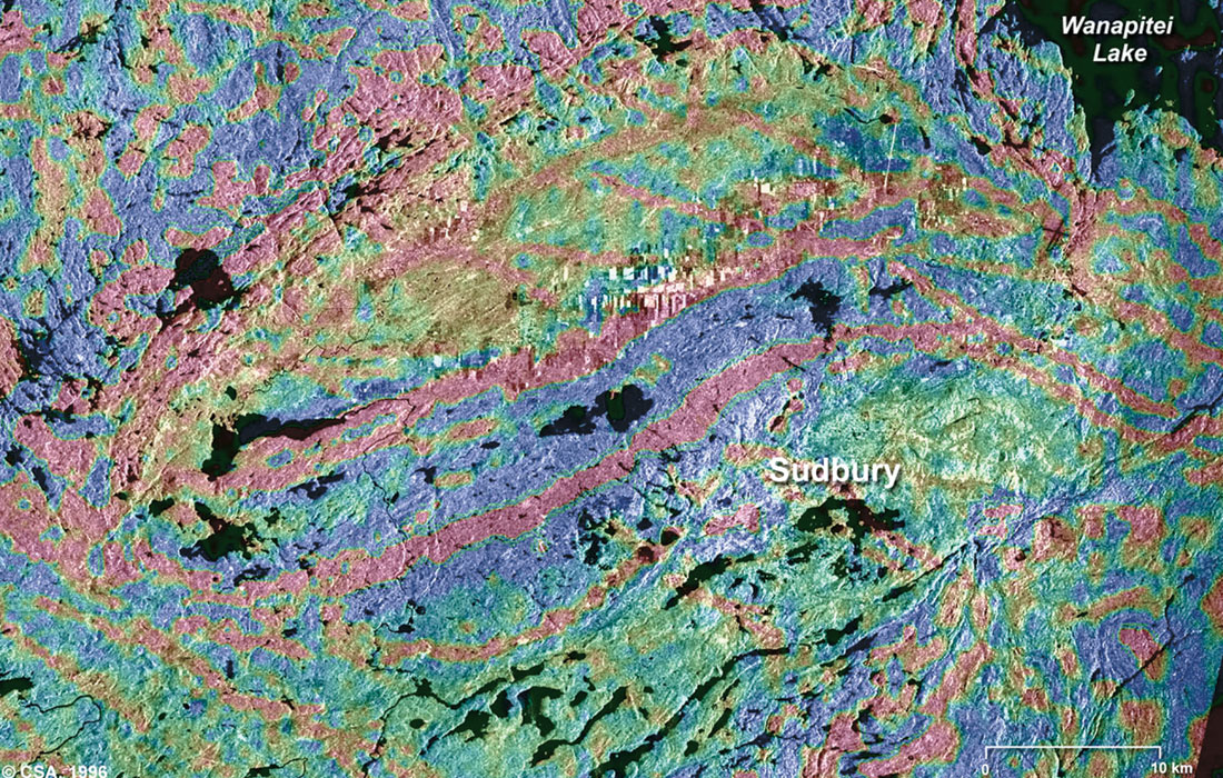
Remote sensing is often combined with other data sources which provide complementary measurements. Multispectral data can provide information on lithology or rock composition while radar provides an expression of surface topography and roughness. Radar data are extremely valuable when integrated with another data source to provide detailed relief. Figure 1 (courtesy CCRS) shows integrated Radarsat and vertical magnetic gradient data over the Sudbury area. Terrain information and the surface expressions of structures are combined with the magnetic signature of geological units to delineate structural trends and lithology.
The first sensors used for remote sensing of the Earth's surface were cameras in aerial photography. Photographic films are sensitive to light from 0.3 — 0.9 μm in wavelength, covering the ultraviolet, visible and near-infrared. Panchromatic films are sensitive to the UV and the visible portions of the spectrum. Aerial photographs are most useful when fine spatial detail is more critical than spectral information as their spectral resolution is generally coarse compared to data recorded with electronic sensing devices. Historically the first photographs taken from a rocket were imaged from a height of about 100 meters from a small rocket designed by Alfred Nobel and launched in 1897 over a Swedish landscape.
The first non-photo sensors were television cameras mounted on unmanned spacecraft and were devoted mainly to looking at clouds. The first U.S. meteorological satellite, TIROS-1 (Television Infrared Observation Satellite), was launched in 1960.
Probably the most famous series of remote sensing satellites is Landsat, whose images are spectacular (see http://landsat.gsfc.nasa.gov). First launched in 1972 as ERTS- 1 (Earth Resources Technology Satellite), Landsat was the first unmanned satellite specifically dedicated to multispectral remote sensing. Landsats 5 and 7 are still operational and orbit the earth in a sun-synchronous pattern in a near-polar orbit. Landsat 5 has MSS (visible and IR) and a thematic mapper while Landsat 7 (operated by NASA and USGS) has an enhanced thematic mapper, which has 6 thermal bands (visible, IR and thermal IR) of 60 m resolution and one panchromatic band of 15 m resolution.
Among the many countries operating satellites are the US, Canada, UK, India, Japan, Russia, Ukraine, China and Brazil (jointly), Turkey, Nigeria and Thailand.
Material for this overview was derived from the websites of the Canadian Centre for Remote Sensing (http://www.ccrs.nrcan.gc.ca) and NASA (http://rst.gsfc.nasa.gov), both of which have an enormous amount of information. The NASA site is an excellent tutorial on remote sensing that has many fascinating images. A very useful and interesting website for images related to geoscience is NASA’s Visible Earth at http://visibleearth.nasa.gov.


Join the Conversation
Interested in starting, or contributing to a conversation about an article or issue of the RECORDER? Join our CSEG LinkedIn Group.
Share This Article