Introduction
The Beaufort Mackenzie Basin (BMB) is emerging as a major potential source for the supply of future North American energy demands. The BMB has always been touted for its resource potential, however, as this abstract will show, there has been significant enhancement in the basin’s potential as a result of new 3D seismic and a fresh look at previous exploration data. New play types, in conjunction with renewed exploration efforts, innovations and cost reductions in Arctic operations, potential for a Mackenzie Valley pipeline and favorable North American supply and demand forecasts, establish the BMB as a significant emerging petroleum province.
The Mackenzie delta is located in the easternmost Arctic Ocean east of the North Slope of Alaska. The Mackenzie River drainage is the second largest in North America and covers an area of roughly 697,000 square miles. It discharges into the Arctic Ocean at a rate of 9,820 cubic yards per second. This compares to the largest North American river system, the Mississippi River, with a drainage area of 1,247,000 square miles and a discharge rate of 22,970 cubic yards per second.
Stratigraphy
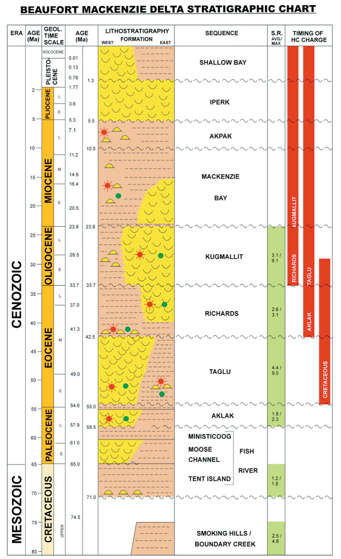
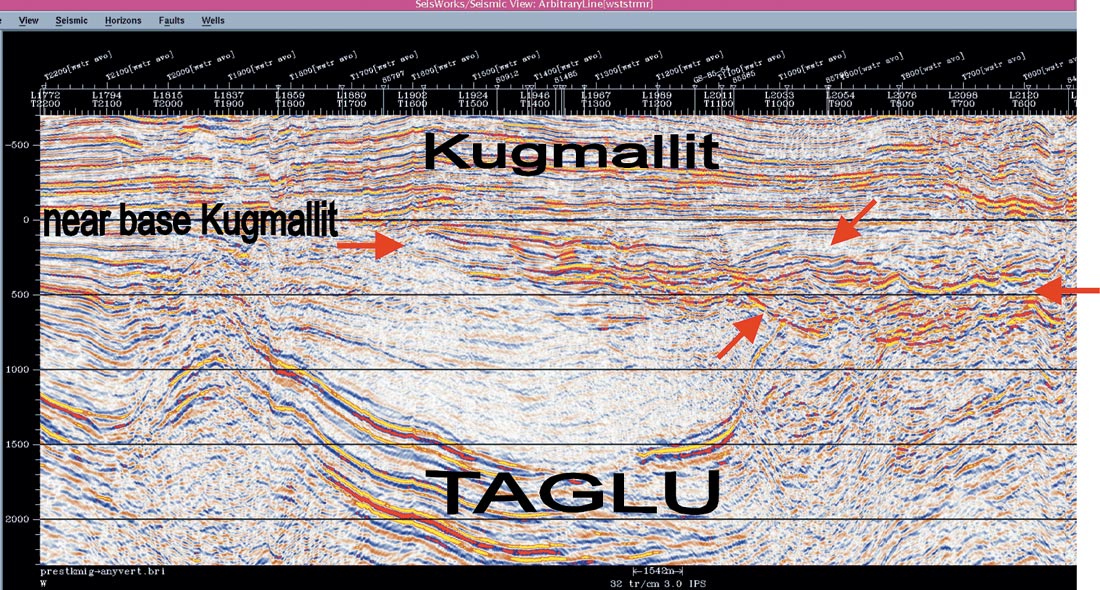
Mackenzie Delta deposition began following the Early Cretaceous formation of the Canada Basin (current day Arctic Ocean). Initial sedimentation during the Upper Cretaceous was restricted to deep marine organic rich muds of the Boundary Creek and Smoking Hills (Dixon et al, 1992). As Laramide mountain building advanced northward, major progradational pulses of sedimentation ahead of the mountain front resulted in the deposition of 12 – 16 km of Tertiary section in the developing Mackenzie delta. Five major deltaic successions, the Fish River, Aklak, Taglu, Kugmallit and Iperk, have been mapped throughout the BMB (Figure 1). The Taglu and Kugmallit contain the majority of reserves discovered to date.
Exploration History
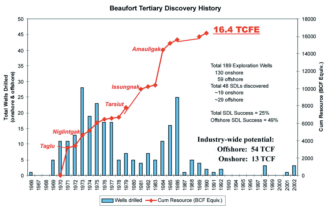
Exploration drilling began in the BMB in the mid 1960’s. Over the next 25 years 189 exploration wells, 130 onshore and 59 offshore, were drilled resulting in the issuance of 48 Significant Discovery Licenses (SDL’s). Of these discoveries 29 SDL’s are offshore with a total reserve estimate of 3.0 TCF of gas and 1.5 BBls of oil, and 19 SDL’s are onshore with a total reserve estimate of 6.0 TCF of gas and 250 MBls of oil (Figure 2). The current total estimate of potential recoverable reserves in the Beaufort Mackenzie Basin stands at 54 TCF offshore and 13 TCF onshore (NEB, GSC, CGPC).
These reserve estimates demonstrate the commercial importance of the BMB, particularly in view of current North American gas markets. With the potential for a Mackenzie Valley pipeline by as early as 2008, the BMB is well positioned to emerge as an important source of supply. These factors led to a resurgence of exploration and development activity in the BMB since 1999. Three years of Federal and Inuvialuit licensing has resulted in the issuance of 20 new Exploration Licenses (EL’s) covering approximately 3,000,000 acres. Since 1999, Industry has acquired fifteen new 3-D seismic surveys along with several thousand kilometers of new 2-D data. Seven new wells have resulted in two new significant discoveries.
A Fresh Look
Analyses of the new 3-D seismic surveys and a fresh look at well data has resulted in the identification of several new Tertiary play types for the BMB, and have clarified several long-standing difficulties with complex structural and stratigraphic interpretations.
New Plays
The 1800 km2 of high-resolution 3D seismic data acquired by Devon Canada in the shallow offshore Beaufort Sea during the summers of 2001/2002, have resulted in the definition of five (5) new Tertiary play types, identification of new prospects in previously defined plays and a better understanding of regional tectonics and depositional environments.
Diapir Flank Play
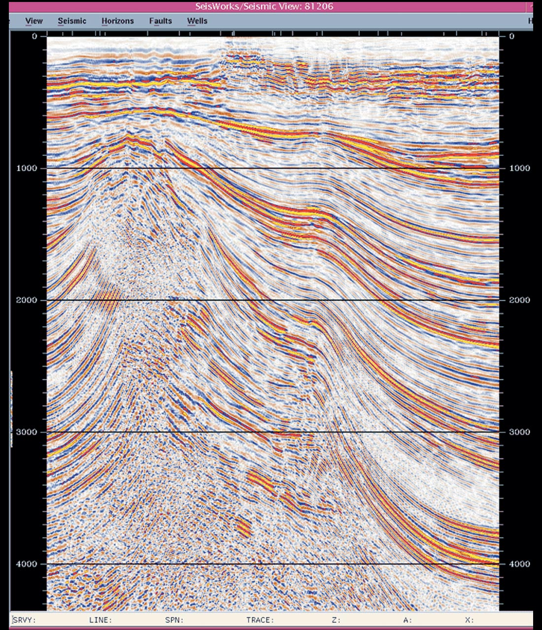
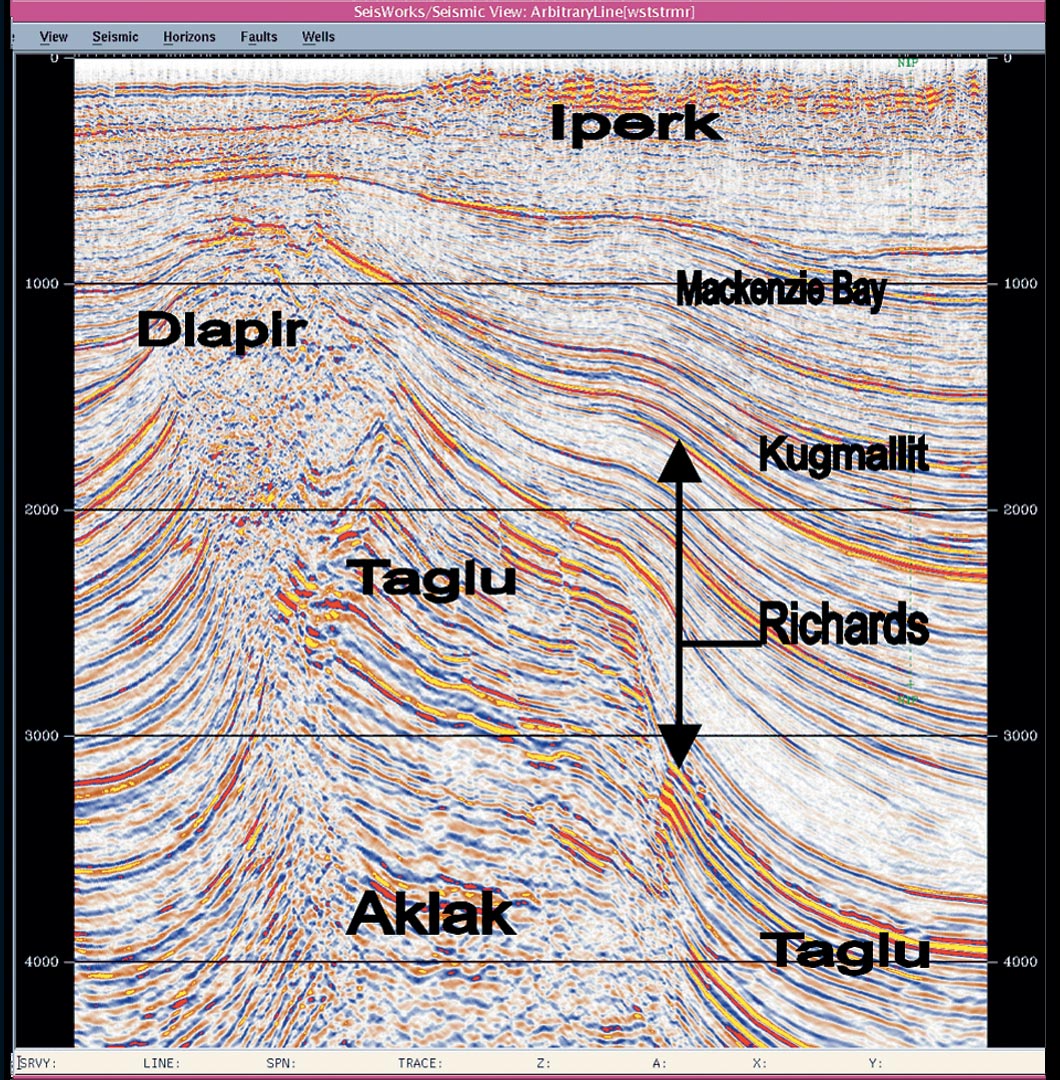
The largest of the new plays is the Diapir Flank Play. From 3D seismic we have interpreted a large shale diapir in the central core of the structure (Figure 4), versus an earlier interpretation of a tightly folded anticline as seen on 2D (Figure 3). The diapir appears to have initiated as an early Eocene-Paleocene growth fault that soled into underlying Upper Cretaceous to lower Tertiary shales. Subsequent SW-NE shortening may have mobilized over pressured clays and mudstones to form the central core of the diapir in the cores of detachment folds. Tectonism continued till the end of the Eocene, followed by local late Tertiary crestal collapse (attributed to dewatering) and renewed compression of the diapiric complex at post-Miocene Mackenzie Bay time. The Diapir Flank play consists of Tertiary-aged sediments flanking, onlapping and overlying an over pressured shale core. Flanking sediments are early to middle Eocene Taglu distal delta front sands and shales transitional to deep-water turbidites in the Paleocene Aklak. The late Eocene Richards onlaps and pinches out on the flank of the diapir, while the Oligocene Kugmallit overlies the crest of the complex. An offset well tested a combined 27.4 MMCF/d from two zones in the Kugmallit and 26 MMCF/d from a conglomerate in the lower Richards. Significant reservoir quality sands were also encountered within the upper part of the Taglu that was penetrated. AVO indicates multiple levels of gas charged sands.
Canyon-Filling Channel/Levee/Fan Play
A second new play of interest is a major canyon-filling slope channel/ levee/ fan succession of the Late Eocene Richards sequence. A combination of 3-D data and biostratigraphy reveals a fairly extensive canyon system with the potential for significant turbidite deposits. The 3D data reveals basal canyon scour followed by aggrading channel and levee systems. Flattened 3D data shows a major canyon system with multiphase down cutting and infilling (Figure 5). Total canyon thickness is on the order of 1000 meters, with at least three phases of infill. The amalgamated width is approximately 20 km, draping over two ridges to the east and infilling lows between them. The play consists of multiple stacked and offset channel/ levee/ fan deposits with a combination structural drape and stratigraphic pinchout forming the trap. An offset well on the southern fringe penetrated a portion of the fill and tested 7 MMCF/d & 120 BOPD from an Upper Richards channel sand. AVO indicates probable gas-charged sands within this upper Richards complex. Worldwide analogies include recent major discoveries at the Girassol field in Angola (Beydoun et al, 2002), the Zafiro field in Equatorial Guinea (Shirley, 2003), the Bonga field in Nigeria (Chapin et al, 2002) and numerous examples in the deepwater Gulf of Mexico.
Additional Play Types
Other new play types include 1} multiple unconformity subcrop plays; 2} base-of-slope and basin floor fans; and 3} wrench-related structural plays in new zones. New prospects in proven plays include segmented crestal anticlines and tilted fault blocks.
New Stratigraphic Interpretation
Stratigraphically, 3-D seismic interpretation in conjunction with biostratigraphic data from multiple sources has allowed for clarification of previous stratigraphic interpretations. In a particular instance, the stratigraphy of a key wellbore had been previously interpreted with older 2D seismic as having significant section removed by faulting. The 3-D image demonstrated that the well had not penetrated any faults and had a continuous stratigraphic succession. Biostratigraphic analysis has undergone a process of quantitative re-analyses of existing data sets, in conjunction with a re-sampling of raw source material from selected wells. The results have significantly improved the identification of key biostratigraphic subdivisions within the BMB. One example has been the ‘pinning’ of a specific shale unit within the Early Eocene Taglu sequence by the recognition of a newly documented foram, C. galgheria (D. McNeil, pers. comm.). Furthermore, correlations throughout Late Eocene Richards have been aided by the recognition of four key biostratigraphic subdivisions (G Dolby, pers. comm.).
Overall, these analyses have helped clarify the stratigraphy of several complex Tertiary aged sequences within the BMB. This process has also aided in the identification of deep-water turbidite equivalents and in defining new reservoir potential for the Richards and Mackenzie Bay sequences.
Regional Tectonics and Sedimentary Environments
3D seismic plus reprocessing and reinterpretation of older 2D data has also provided a much clearer understanding of the regional tectonics and depositional environments. Prior to the Early Cretaceous, the BMB was the northern continuation of the ancestral western margin of North America and thus its structural- tectonic history during this period is the same as that of the Western Canada Sedimentary Basin. Mackenzie delta depositional history begins in the Early Cretaceous with the opening of the Canada Basin (Arctic Ocean). The Smoking Hills and Boundary Creek formations were deposited during the Late Cretaceous along the rift margin as it thermally cooled and sagged. As Tertiary Laramide mountain building progressed northeasterly across the passive margin, the Canada Basin provided accommodation space for the large volumes of sediments being shed from the advancing mountain front. Deltaic sediments of the Paleocene Fish River began to appear in the Western Beaufort as the Mackenzie Delta depocenter shifted north of advancing Laramide (or Brookian) mountain building. Deltaic sedimentation continued to be focused in the Western Beaufort through the Paleocene Aklak and on into the Early to Middle Eocene Taglu. The depocenter shifted to the northeast for much of the Late Tertiary and was dominated by the Oligocene Kugmallit deltaics. Sequence stratigraphic interpretation of 3D seismic, along with core analyses and biostratigraphic revisions identify deepwater ‘turbidite’ equivalents to each of these major sequences, as well as to the Late Eocene Richards. The entire basin has undergone uplift from the south and the last major deltaic pulse, the Plio-Pleistocene Iperk, regionally truncates most of the BMB with substantial erosion. Growth faults record the depositional timing of these major Tertiary deltaic sequences as they stepped northeastwards, and thinning of beds onto large detachment folds record the timing of later Laramide contractional deformation. The detachment folds formed above a mobile shale substrate and as a result shale diapirs appear to core many of the large ridges in the BMB. Because Laramide mountain building swept obliquely along the continental margin, there is a significant right-lateral component to the Tertiary structural history of the BMB.
New Geochemical Interpretation
The BMB’s hydrocarbon potential has been enhanced by a reexamination of the basin’s geochemistry. Historically, the Richards was identified as the primary source sequence for Tertiary oil accumulations. This association was based on analyses done by Brooks (1986, 1986a) who established a link between Tertiary oil biomarker 24-28 bisnorlupane and its occurrence in Richards kerogen. This conclusion restricted the amount of hydrocarbon generated in the BMB since the Richards generally has marginal organic richness and thermal maturity. Recently, Snowdon et al (pers. comm.) were able to demonstrate that this same compound also exists in the Lower Eocene Taglu, thereby broadening the potential Tertiary source sequences. The common occurrence of gas in the delta along with the relatively high TOC coaly sections in other more mature sections of the stratigraphic column also point to a much richer source potential for the BMB than simply the Richards. Modeling of existing source rock data indicates that the primary source intervals for the Tertiary BMB are likely the Paleocene Aklak and Early to Mid Eocene Taglu. Local contributions also occur from the Late Eocene Richards, the Oligocene Kugmallit in the northern portion of the basin, and the Lower Tertiary Fish River and the Upper Cretaceous Smoking Hills / Boundary Creek to the south. All of these source rocks, except the Upper Cretaceous Smoking Hills / Boundary Creek, are Type III coals or coaly intervals with sequence-average TOC’s from 1.5% to 4.5% and Hydrogen Indices up to 450 kg/t. In light of these new findings, the BMB has been transformed from a source limited Richards hydrocarbon system to a rich and mature Tertiary system with a greatly expanded range of prospectivity.
Operational Innovations
Recent innovative operational technologies decrease time, increase safety and significantly reduce costs. Arctic class, purpose built rigs have demonstrated an average reduction in drilling time by 25%. Large service rigs have been utilized for shallower onshore wells to reduce mobilization costs and to reduce the environmental footprint. In the offshore, innovative drilling and well control systems will dramatically decrease well costs and increase drilling seasons, while maintaining strict environmental safeguards.
Conclusion
This combination of new exploration data, world class plays, operational innovations, a developing infrastructure and long-term North American gas demand are behind the recent surge in exploration activity, and establish the BMB as an emerging production province for Canada.


Join the Conversation
Interested in starting, or contributing to a conversation about an article or issue of the RECORDER? Join our CSEG LinkedIn Group.
Share This Article