Abstract
The study area (72°N, 33°50’E and 72°30’N, 33°25’E) needs more investigation over the Recent to Eocene time span with regard to the structural changes occurring within different parts of the region. The author tried to study the general geological and geophysical results of the Indo-Eurasian collision (with stable Asia rotational wrenching) that formed after the convergence of the southwards lesser force vector from the Tadjik Basin area (east of Tibet) with the northwards directed stronger force vector of the Indian continent. Special emphasis has been made on the E-W structural trend with tight anticlines and wider synclines in the East of Kohat and even tighter synclines in the western-most part of the Kohat area. The Kohat and Kuldana formations are the only representatives of the Middle Eocene in the Kohat-Potwar Basin. Relative to Potwar, the Salt-Range facies in the Kohat area are more basinward and were affected in the Early to Middle Eocene during the early stages of the Himalayan orogeny. The unconformity predictions and stratigraphic chart helped in the understanding of the regional geology and were key to the sequence and seismic stratigraphy. Moreover, the seismic interpretation is based on seismic attributes, configuration and patterns. The surface outcrops and subsurface above the Eocene is more deformed compared to the lower Eocene Competent package. The north and northwestern area of Kohat have more tight and deformed structures compared to the south and southeastern areas due to rotational activity. The whole Kohat region, like Potwar, is composed of imbricate wrench faults which are gentle in the Potwar area while steeper in the Kohat area. In the eastern part of the area, duplex structures formed in the Kohat Formation. The western part of the area has more tectonic deformation compared to the east part of the Kohat region.
Introduction
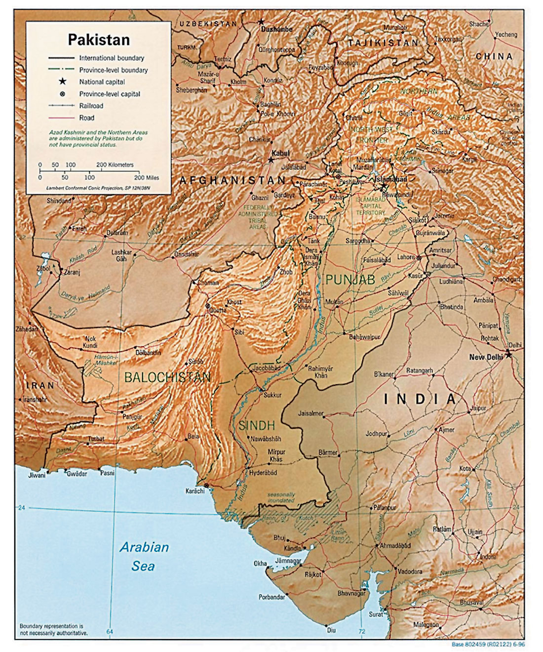
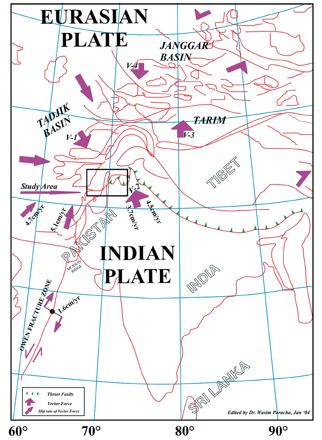
The study area lies between the northern Pakistan border and south of China border (Fig. 1). The Indo-Eurasian collision affected more intensively the western region of the collision plate compared to the eastern region due to uneven convex curve structure. Horizontal shortening and vertical thickening of crustal rocks and the generation of high mountains characterize the deformation within regions of lithospheric convergence. The northern part of Pakistan has been deformed tectonically as a result of continent-continent collision of the Indo-Eurasian Plates. After the collision, a SE to NW rotational movement of the continent resulted in structural changes occurring in the area. This collision and later rotational movement have resulted in a WNW-ESE trend of thrust tectonics in the Potwar area (Paracha, 2000) while it has been observed that within the Kohat Basin area the trend changes rapidly to NNE-SSW. The two force vectors (Fig. 3) causing the rotation movements are the one southward vector from Tadjik Basin with its eastern limb greater than the western limb while the second vector is northward from south of Pakistan with its western limb greater than the eastern limb. Accordingly, the northern area became geologically higher (even as outcrop deposits) compared to the adjacent areas and the stratification in the area has been affected by the difference in thickness between the east and west of the Kohat region.
The N-NW directed movement of the Indian Continent was slow in Eocene time when the Chitral/Kohista Island Arc system initially contacted the southern continental margin of Eurasia. The Indian Continent began a counterclockwise rotation, developing the stable shallow water carbonate platform with a few depressions in the Sulaiman Basin and restrictions in the Kohat Basin (Qadri, 1995). As a result of these tectonics, the geologically folded structure seems to be an E-W directed plunged antiformal culmination having the Khushalgarh area in the centre with a high elevated area.
The structural and tectonic setting changed rapidly towards the west of the area during the Eocene-Paleocene interval (Paracha, 2001). The Kohat Basin area of the Kohat- Potwar Plateau is the most complex tectonic area of northern Pakistan. The Kohat region in northern Pakistan area is a complex tilted plateau and also sometimes similar to a “Cuesta” region with its difficult geological attributes, e.g. moderate-steeper dips and asymmetrical structures which may have been formed by a large number of thrusts/normal faults. The interpretation results of the geological and geophysical data have indicated that the studied area had a number of salt-affected and/or basement involved thrust/reverse faulting systems formed as a result of transpressional tectonics in the area (Paracha, 2001). The Kohat, Chorgali and Top Paleocene formations were studied, interpreted and mapped with reference to geological structure and hydrocarbon prospecting of the area (Paracha 2001). The study of the whole area is based on the surrounding well data, e.g. Tolanj-1 (AMOCO), Ratana-1 (OPI), Jalwal-1 (POL), Garhi- 1 (OGDCL) and Dakini-4 (OGDCL), Khushalgarh area maps, previous seismic data, velocity analyses of Jalwal, Dakini and Ratana wells, published literature and outcropping rocks. The surface and sub-surface comparison has also been made to understand the deeper zones of the area.
The Indo-Eurasian obduction has formed a number of parallel complex tight thrusts in the area. The magnitude of the tectonic vector forces effect is more intensive in the western part compared to the eastern part, as a result of which the tectonic rotational activities have occurred. Thus, the tectonic potential is greater in the western part than in the eastern part of the Kohat-Potwar sub-basin. The northern area of the Kohat Plateau is more deformed compared to the southern and southeastern areas. The seismic study has shown the duplex features in Kohat Formation and the detachment profile between the competent and incompetent zones (Paracha et. al. 2000).
Thus, it is difficult to tie the geologic structural features with surrounded areas even after the seismic study. The most significant feature of the area is the correct geological division and exact marking of the location. The geology of the area is different from that of southern Potwar and the westernmost Kohat Basin.
The Kohat-Potwar plateau on the southern part of the Himalayan and Karakorum orogenic belt is a result of compressional tectonics after the Indo-Eurasian collision. The Kohat- Potwar plateau is bounded to the north by the Kalachitta Hills. The Salt Range and Trans-Indus Range mark the boundary to the south. The western boundary is marked by the Kurram-Parachinar Range. The River Indus separates the Kohat-Potwar Plateau into the Potwar area on the east and the Kohat area on the west. The Kohat Plateau is located between latitude 32N and 34N and longitude 70E and 74E (Fig. 1). The geological map of Kohat Plateau has been published by the United States Geological Survey (Meissner, et. al. 1974, 1975). Tight east-west striking anticlines are cored by steep reverse faults with broad synclinal valleys separating them (Sercombe, et.al. 1998).
Though the area falls into the category of geotectonics classification which accounts for 48% of the world’s known petroleum reserves (Riva, 1983), the area still offers a large frontier prospect for hydrocarbon exploration as it lacks exploration and drilling activities.
The collision of the Indian and Eurasian plates is characterized by continent-continent collision, obduction and thrusting in the northern area and it is considered to be the prototype Alpine- Himalayan orogeny (Farah et. al., 1984).
Geological Study
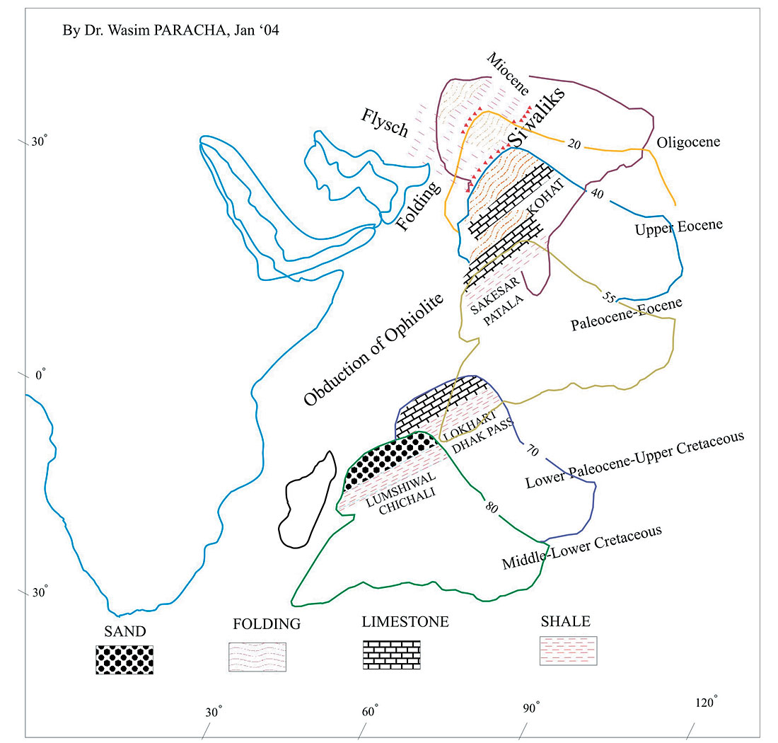
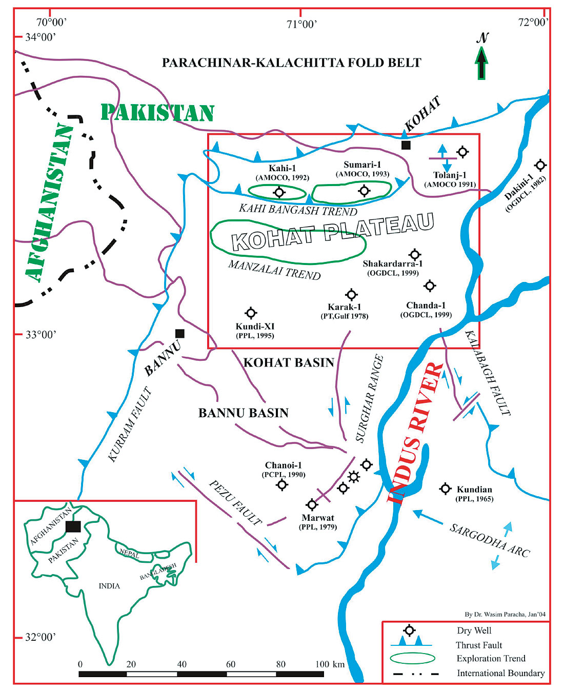
The Himalayan mountain belt was formed by north-south shortening and crustal thickening during convergence between the Indian and Asian Plates after their collision at about 45 Ma (Gansser, 1964; LeFort, 1975; Fig. 1) and thus underlying the northern Tibetan Plateau are thrust structures like the Kohat Plateau. The Kohat-Potwar Plateau forms the northernmost element of the Indus basin and is bounded in the north by the Kalachitta fold belt through a system of faults. The Salt Range composite orocline forms the southern limit. The Kurram thrust fault marks its western limit. The Pezu wrench fault separates the Kohat depression from the Sulaiman fold belt. The general stratigraphic column is shown in Fig. 5.
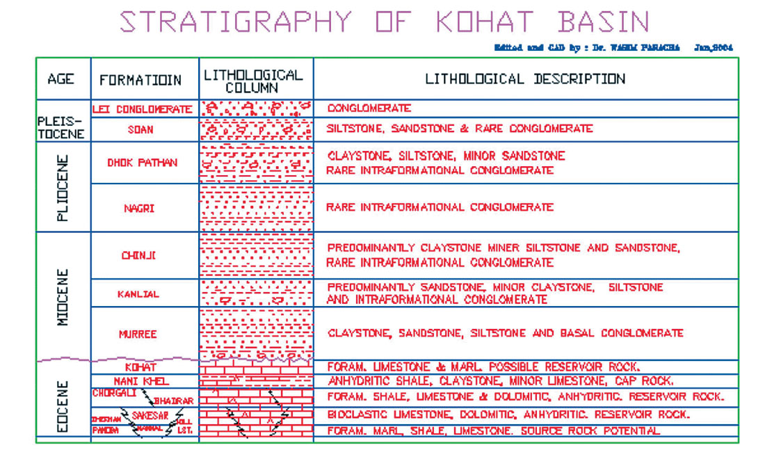
The existence of Early Eocene evaporites more in the Kohat area than in the Potwar Plateau indicates the limits of basins in the local region. The geology of the studied area is shows that the whole region is salt-affected thin-skinned and basement-affected, detachment formed thick-skinned with the weak and broken upper ductile multi-fractured Incompetent Package (Miocene age) with a detachment line and the strong lower viscous stable Competent Package (Eocene). Throughout the area a WNW-ESE oriented pattern of pop-up thrust faulting system has been noted (Fig. 4). In the Kohat area, green Panoba Shale with dispersed glauconite may suggest a marine stillstand while hemapelagic deep-sea clay including glauconite shows a low sedimentation rate in the area. Towards the end of the Early Eocene a widespread but short-lived regression occurred in the Kohat and Potwar areas. This has been confirmed by the presence of a series of gypsum and/or gypsiferious shales in the Kohat Salt associated with such evaporites (Qadri, 1995). The widespread transgression that started in the late Lower and early Middle Eocene reestablished marsh conditions rapidly over the entire area. The transgressive Kuldana Formation resting on Chorgali was deposited in a coastal or tidal brackish water environment. It consists of a very characteristic red-brown to brown fluvial/alluvial plain claystone/ shale interval which indicates the peak of arid climatic conditions. Limestone is again the dominant lithology in the transitional marine Kohat Formation.
In the Potwar area, particularly in the west of Kohat Basin, the partial separation from open sea caused the development of a restricted marine evaporite trough. A basal infilling gypsiferious claystone (Panoba Shale equivalent to Nammal Formation) was followed by about 300 meters of rock salt (Bahadurkhel Salt equivalent to Sakesar Formation) and a second layer of about 40 meters of gypsum also containing some oil-rich shale called Jatta Gypsum (equivalent to Chorgali Formation). The different tectonic movements responsible for the formation of an evaporite basin were related to the general uplift of the northwestern Indian Craton area from Middle Eocene to Oligocene time.
The axis of the Indus Basin trends East-West within the Kohat- Potwar depression and roughly follows the Soan River Drainage (Khan et. al., 1986). Sedimentary rocks of Paleocene to Pleistocene crop out on the Kohat Plateau. The Tertiary foredeep basin developed between the colliding Indian and Eurasian Plates. Then it evolved to become a restricted evaporite basin, an early terrestrial foreland basin, an open marine basin, and finally a fully developed terrestrial foreland basin that was deformed in the Pliocene-Pleistocene (Pivnik and Khan, 1996 and well data). No rocks earlier than Eocene age are exposed in the Kohat plateau (Meissner et. al., 1974).
The surface structural geology is dominated by east-west trending anticlines having both limbs overturned and steep down plunged ends. The anticlines are separated by broad synclinal valleys in which the Neogene fluvial foreland basin deposit crops out (Sercombe, et. al., 1998). Recent deposits cover the Bannu basin at present in the south of the Kohat Plateau. The Kohat portion of the upper Indus Basin is similar to the Potwar area but the regional stratigraphy made a difference between these two large basins. Both the basins have gone through a similar evolutionary history. The Potwar Plateau has subdued relief compared to Kohat Plateau, having a downplunge geographic extension of the Kohat Plateau (Sercombe, et. al., 1998). The topographically rugged Kohat Plateau is bound to the south by the Trans-Indus Salt Range and Bannu Plain (Searle et.al., 1996) and to the north by the Main Boundary Thrust (MBT). The transspherically deformed Axial Belt bounds the western margin while eastern boundary is the Indus River, which has been deflected eastward during deformation in the Kohat Plateau and trans-Indus Salt Ranges (Mc Dougell and Khan, 1990; Pivnik and Khan, 1996).
Relative to the Potwar region, the frontal salts and trans-Indus ranges facies at Kohat are more basinward and affected in the Late Early to Middle Eocene during the early stages of Himalayan Orogeny when remnants of the Tethys shrank to the size of small brackish water bodies. In comparison to Potwar, the Middle Eocene is better represented in the Kohat area. The Lower Eocene (Chorgali Formation) is active but deformed towards the west of the Kohat area compared to east of it. The steep dips and throws of wrench faulting systems in the area prove the rotation of the continent to northwest from southeast.
Kuldana Formation:
In the Hazara District, the Kuldana Formation consists of multi-coloured Marls and Calcareous conglomerates. Red Sandstone is also common. In Kalachitta and northern Potwar, it consists of greenish grey to brown silty gypsiferous shales. In Kohat, this formation is composed principally of brownish red calcareous, silty clays with thin beds of sandstone near the top. It is exposed in the southern Hazara and northern Rawalpindi areas extending through northern Potwar and Kalachitta to the Kohat area. It reaches about 150 meters (500 ft) in Hazara and northern Potwar. The presence of fauna gastropods, fresh water bivalves and other fossils indicates that the formation was deposited in a transitional environment with probably more marine fresh water influence. In the Potwar, Kalachitta and Hazara areas it overlies about 66 meters whereas in the Kohat area it is conformably underlain by the Jatta Gypsum. In most areas, the Kuldana is firmly overlain by the Middle Eocene Kohat Formation except in southern Hazara and Kalachitta where the Early Miocene Murree Formation unconformably overlies it. Based on stratigraphical evidences the age is interpreted to range from Early Eocene to Early Middle Eocene.
Kohat Formation:
The Kohat formation consists of light grey to cream coloured massive to nodular limestone with marl and also green shales. In some areas this formation may appear as “Reservoir Rock”. This formation is divisible into three members:
- Kaladhand Limestone Member: The basal member, which consist of light grey, hard, dense thin-bedded limestone with thin shale beds, especially in the lower part. This unit becomes more massive from east to west.
- Sadkal Shale Member: The middle unit consists of greenish grey calcareous shale and light grey limestone with abundant Foraminifera (Nummulites). It is mostly found in the northwestern Kohat area where the shale is well developed.
- Habib Rahi Sandstone Member: The upper member is composed of cream coloured, hard, dense, thick bedded to massive limestone that is fractured and brecciated in the top few meters. The formation is restricted in Kohat, northern Potwar and Kalachitta to up to 180 meters (590 ft) of thickness. A rather shallow marine environment due to little continental influence has been noted in the area. The Kohat formation lies conformably in sharp contact with the Kuldana formation but is unconformably overlain by the Murree Formation of Miocene age. A thin conglomerate bed of limestone pebbles usually marks the upper contact and matrix derived from the Kohat Formation.
Geophysical Study
The geophysical study is based on the seismic interpretation of the northern area of Pakistan. The northern part of Pakistan is extremely affected mostly by the thrust tectonic system, which is due to forced collision from two differently directed vectors. The vector force named here as the Kirthar-Sulaiman Range Vector acts from S-SW to N-NE with a rotational axis lying approximately between the Peshawar (Pakistan) and Gardeyz (Afghanistan) (Fig. 1). The other force vector, named here as the Tadjik Basin Vector, acts from NW-SE with the same axis of rotation. It is noticeable (as mentioned earlier) that the vector acting from the west (Tadjik Basin Vector) has greater magnitude compared to the vector from the east (Kirthar-Sulaiman Vector) side.
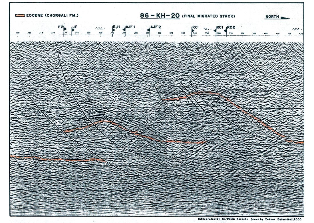
The seismic stratigraphy study of this complex area has shown different types of imbricates, thrust/overthrust and pop-up structures (Fig. 4) that indicate the initial stages of duplex, sometime triplex, thrusting, which also suggests a wrench faulting system in the region.
The seismic-stratigraphical study also permitted an interpretation of the tilting history, unconformities and the depositional history to produce the approximate structural mapping of interpreted litho-facies found on the seismic sections.
The available seismic sections that are interpreted show almost all seismic stratigraphical facies features.
The reflection configuration of these seismic sections is complex and oblique to sigmoid type that indicates the high-dip to moderate dip bedding pattern and which show the high energy to low energy depositional processes.
- The Reflection Continuity has shown the bedding continuity.
- The Reflection Amplitude has given us the idea of bed spacing, fluid content and the velocity-density contrast in the region.
- The Reflection Frequency has indicated the thickness of the bed.
- The Interval Velocity has suggested the approximate estimation of the lithology and porosity.
- The gross depositional environment, sediment sources and the geological setting have also been studied.
Although the time-stratigraphy was difficult to study, the author has tried to indicate the most important parameters about the attitude of seismic reflection, its continuity, pinch-out, baselap, toplap, onlap and truncations etc. It is also noted that the isochronous reflection study was difficult due to the complex area and poor quality of seismic data acquired in 80’s with no proper seismic techniques.
The quality of the seismic profiles can be understood by the observation that the strongest reflection coefficient marked on seismic sections may be due to Eocene Limestone (most probably the Chorgali Formation). It has also been noticed that short popup structures have very weak reflectors beyond 3 seconds on seismic sections. For analyzing the fracture manifestation, the Amplitude Variation with Offset (AVO) of any seismic line may considered. The character of seismic amplitude shown in the seismic section here in this paper plays an important role in the identification of fractures and H/C accommodation conditions. The increase in amplitudes suggests the possibilities of fractures and/or gas filled fractures while the dimming/weakening of any amplitude implies the opposite. The AVO gradient (the change in AVO) or linear variation is proportional to the Poisson’s ratio across the reflecting interface and because the effect of pore/fracture space results in a decrease in Poisson’s ratio for the rocks, the AVO method is applicable for gas detection.
The seismic data quality in the Kohat area in general grades from poor to very poor due to shallowness and tight structures while the seismic facies and sequences are fair to good. In this area the seismic amplitude is of higher frequency, still having interpretable access. The seismic configuration and seismic attributes are fair to good, which plays an important role in the interpretation of seismic sections.
Stratigraphy
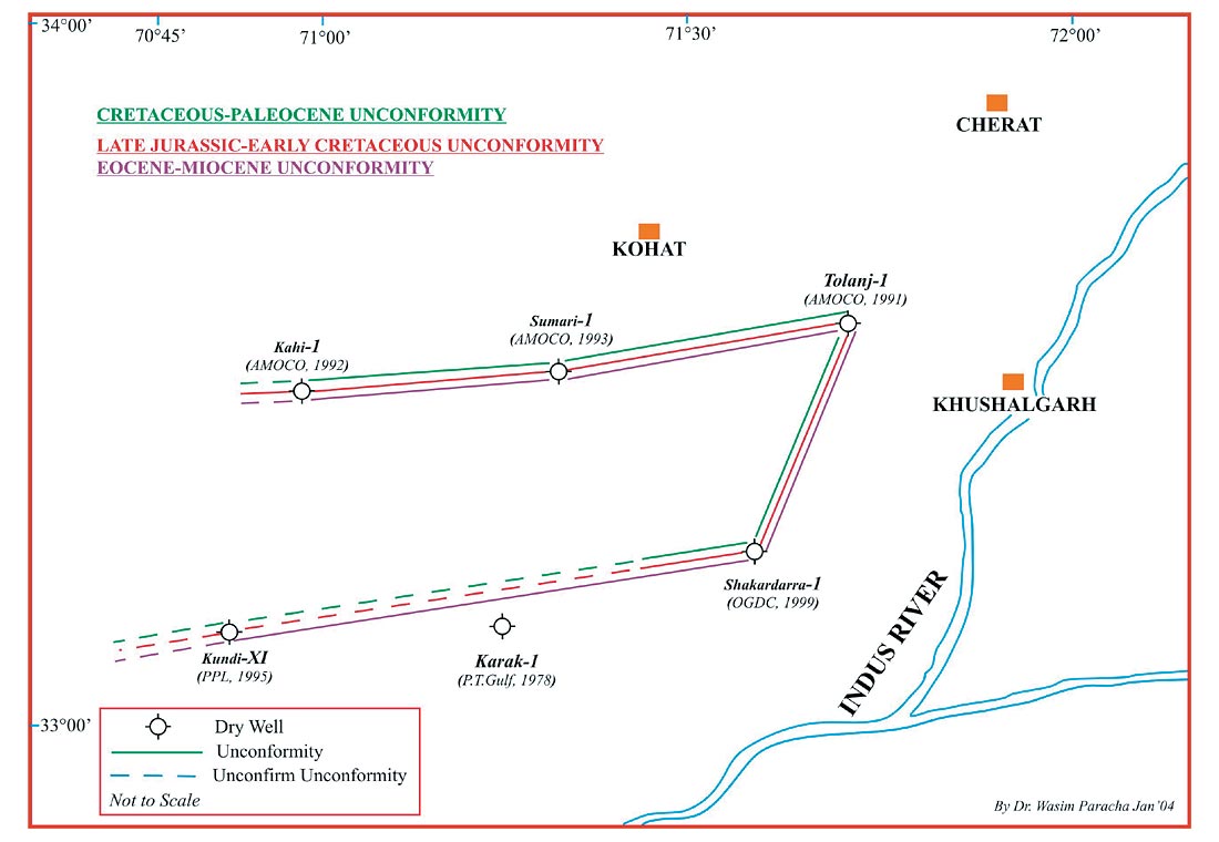
The sedimentary deposits found in the area are from Pre-Cambrian to Recent. The deposition was interrupted several times. The two identified unconformities are Cambrian- Permian and Eocene-Miocene in the area. The Late Jurassic- Early Cretaceous, Cretaceous-Paleocene and Eocene-Miocene unconformities are also marked (Fig. 8). An attempt is made in this paper to mark the unconformities through the data of Kohat wells.
Miocene-Eocene Unconformity
Non-orogenic movements mainly caused by various cycles of uplift affected pre-Eocene deposition. During the late Eocene, the area emerged out completely while the seawater withdrew from the area (Fig. 8).
Cretaceous-Paleocene Unconformity
In the Cretaceous, the area emerged out of the sea and erosion followed (Fig. 8). The emergence was more intense south and east of the area, as witnessed by the absence of the Cretaceous section (Khan, et.al. 1986).
Jurassic-Cretaceous Unconformity
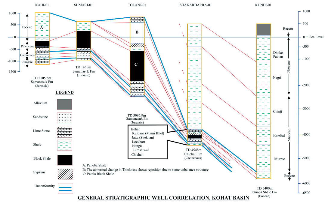
The area emerged out of the sea in the Late Jurassic and sedimentation started again in the Cretaceous, resulting in an unconformity (Fig. 8). The subsurface stratigraphic sequence in the Kohat Plateau cannot be demonstrated as the area is not fully exposed and the data available is insufficient. The generalized stratigraphic correlation of a few wells in the Kohat area was shown in Fig. 6.
In the western part of the area, the Kahi-1 well has Panoba Shale (Eocene) exposed. The well was drilled into the Jurassic. East of Kahi-1, Sumari-1 was drilled where the thickness of Paleocene Patala Shale has increased towards the east (Fig. 6). NE of the Kohat Plateau Tolanj-01 was drilled where Kohat Limestone of Eocene age is exposed. The well shows the repetition of Eocene rocks due to the formation of faults. At southern Kohat, Shakardarra-01 was drilled where Pliocene sediments are exposed. Shakardarra-01 limestone (Cretaceous) is absent in the section.
Lockhart Limestone (Paleocene) is not encountered in Sumari- 1. The Chichali Formation (Cretaceous) is missing in Tolanj-1. To the SW of Kohat, the Kundi-X1 well was drilled into Eocene rocks at about 6000 m while in the outcrops of Kohat, the Eocene is exposed. This shows that in the north and northwestern region of the Kohat Plateau, Eocene rocks are exposed while in the southern region Pliocene and recent materials are exposed. The thickness of Paleocene-Eocene rocks varies dramatically from East to West (Sercombe et.al. 1998).
Exploration History
Amoco Pakistan Exploration Company (APEC) drilled three wells between 1990 and 1993 in the Kohat plateau: Tolanj-1, Kahi-1 and Sumari-1. The Tolanj-1 well revealed a complex flower type structure, which indicates that it is not a thrustrelated structure or an evaporite cored anticlinorium and salt was not encountered in the well (Sercombe et.al. 1998). Several other companies have also explored the Kohat Plateau area in different times, including Amoco Pakistan Exploration Company (APEC), Pakistan Oilfields Limited (POL), Oil and Gas Development Limited (OGDCL), Pakistan Petroleum Limited (PPL), and MOL. In 2002, MOL(Tal Block) encountered gas in the Kohat area.
Hydrocarbon Potential
The Indus basin, including the Kohat-Potwar depression, belongs to the category of extra-continental downward basins which account for 48% of the world’s known petroleum resources (Riva, 1983).
The Kohat-Potwar depression has several features that make it a favourable site for hydrocarbon accumulations. Located on a continental margin, the depression is filled with thick deposits of sedimentary rocks, including potential source reservoir and cap rock (Fig. 6). It contains a thick overburden (about 3000 m) of fluvial sediments, which provide the burial depth and optimum geothermal gradient for seeps found in this area (Khan, et.al. 1986).
Only structural traps have been exposed. Besides structural traps, stratigraphic traps should be exposed. The truncation of several strata, pinch out and unconformities suggest that there may be stratigraphic traps in the region.
Simple and translated fault-propagation folds form important structural traps in fold and thrust belts. The most important traps in fault propagation folds are in the crests of major anticlines. These fault traps may be present along backlimb thrusts, between the imbricates in the forelimbs and in upturned beds in the footwall. Secondary traps may also be present within major thrust sheets, particularly at the leading edge of the thrust sheet and above footwall ramps (Mitra, 1990).
Source Rock
The upper most formation of Paleocene age in the Kohat- Potwar depression is the Patala Formation. This formation is of extreme importance as it is considered to be the main source rock for oil and gas produced in the basin. Studies by HDIP (Pakistan) and BGR (Germany) also reveal that Patala shales are the main potential source for hydrocarbon generation. The northern part of Potwar has been proven to be the main producing region for oil and gas in the area while the Kohat area, due to its structural trend and tectonic pattern, has potential for hydrocarbons.
Conclusion
The wrench faulted, imbricate structured Kohat Plateau area is broad (~200 km) and dips gently at <3¥. Overthrust complex belts have been interpreted with unreliable broader group length 2D seismic data acquired from different exploration companies, thus it is recommended to apply 3D seismic techniques to understand at least the proper structure of the area. It is clear that 2D time migration does not suffice in delineating targets on such imbricate structures due to sideswiped energy gathering. This can be cleared by 3D migration in the seismic section (Yilmaz, 1987). It is also important to have good quality seismic acoustic impedance, wave signals in the seismic expression and seismic inversion for velocity/density ratios.

Acknowledgements
The author acknowledges the MD, Petroleum Geology Investigators ApS, DENMARK, Oil and Gas Development Corporation Ltd., PAKISTAN and Pakistan Oilfields Ltd., PAKISTAN in helping to publish this paper. The author pays thanks to people in reviewing/suggestions for the paper. The author specially is grateful to all helping hands in preparation of this paper.


Join the Conversation
Interested in starting, or contributing to a conversation about an article or issue of the RECORDER? Join our CSEG LinkedIn Group.
Share This Article