The planning, organization and management of hydrocarbon exploration and exploitation operations requires accurate, complete and current maps illustrating the topography and surface features whether man made or natural. This information is invaluable for seismic planning and operations, well site planning and facility engineering. All aspects of surface activity from planning through operations to asset management rely on the use of accurate spatial data to provide a clear picture of the surface environment prior to, during and after any surface operation.
The adage "a picture is worth a 1,000 words" is most applicable to a map. Conventional line maps, particularly of a technical nature, often lack identifiable detail in order to simplify presentation and be legible. Conventional line maps are often difficult for the inexperienced map user to orient to and understand. The more a map starts to look like a picture, however, the easier it is to relate to reality.
An aerial photo or a satellite image provides the best visualisation of the earth's surface in that the picture contains recognisable features that the average individual can comprehend and visualise. Unlike maps created from vector data, aerial imagery contains all features that can be observed from the air. Unfortunately aerial photography and satellite imagery may have significant distortions and scaling inaccuracies that preclude its use for accurate and detailed mapping unless the distortions are corrected and removed. The distortion and scaling problems can be corrected in a process called orthophoto rectification. Orthophoto rectification has been available for 30 years but in the past was costly and involved a time intensive photographic process. New orthophoto rectification procedures have been developed in the last several years that use digital techniques. The original image is electronically scanned to provide a digital version. The scaling and distortions in the original image can be removed through spatially readjusting the pixel locations in the digital image. The end product is a properly scaled and accurate geo-referenced digital photographic image.
The use of digital aerial photography has steadily gained widespread acceptance over the last few years, partially because the desktop computer can now manage the large data files and photomaps can now be plotted relatively inexpensively. In addition, land use activity now increasingly employs the use of capital-intensive equipment with high operating costs; thereby well-planned and well-executed operations create significant cost savings to the operator and ultimately, to their client. Compliance to stringent government land use regulations requires special attention to the degree, location and timing of surface disturbances which can best be planned for and operated in conjunction with accurate aerial imagery.
Advances in computer hardware, digital processing and compression technologies in recent years have made it possible to acquire, process, store and maintain large inventories of digital imagery. Advances in communications technology, particularly large bandwidth development (the capacity of a communications mechanism to transmit data), have provided the process to distribute that information efficiently to all land use stakeholders. The high capacity Compact Disk has traditionally been used for digital photo data storage. In the past year, the “web” has become the distribution mechanism of choice to deploy interactive high-resolution digital imagery to every application from simple image viewing tools to sophisticated Geographic Information Systems (GIS).
Traditionally, operators have employed the services of aerial photo service providers to acquire, develop, process and deliver imagery on a project specific basis. Unless the photo has been already acquired and processed, the delay time to receive the product often exceeds the opportunity window for the operation and the planner resorts to either using uncorrected raw photography, old imagery or none at all. The process of acquiring project-based imagery can be expensive and is often duplicated by a multitude of companies and government agencies. The concept of a central repository of high resolution, spatially accurate digital ortho photography that provides real-time online distribution results in a significant overall cost savings by which all participants share benefits.
The VISION 2000 Project, initiated in 1998, was developed to create online seamless digital ortho-corrected aerial photography coverage of the province of Alberta. The library is unique because of its high accuracy (2 to 10 metres), high resolution (less than 1 meter ground sampling) and Internet access. The VISION 2000 (V2K) initiative allows customers to access the aerial photo library via the Internet or by other conventional means, including CD or as paper maps. The library is housed in a web server facility at Telus Advanced Communications in Calgary and served via fibre optic cable, conventional copper or Internet to customers around the world.
The size of the seamless digital orthophoto library is staggering: approximately 16 terabytes (trillion) of raw scanned color imagery for the entire province is converted through processing into 2.3 terabytes of orthophoto. That equates to, in digital data storage volume, a single 3D seismic survey the size of the entire province of Alberta. With compression, approximately 153 gigabytes (billion) of data is stored on a direct access disk farm on the web server computer. In order to provide fast, multiple account access and instantaneous real-time retrieval of the data, a GIS system manages the locating and downloading. The extraction (and compilation if the request spans across two or more files) of a particular image is accomplished with decompression algorithms that allow a user to create an image of any size of any ground resolution. For example, a single square kilometer of orthophoto extracted at the maximum 1m ground resolution contains 100,000 pixels, or approximately 1MB of 24-bit color data, uncompressed. If the user requires 5 meter ground resolution, an image of the same file size would cover 25 square kilometers. Normally, this process would take several hours to locate the multiple files, load, merge, crop, parse and geoposition the request. Leading-edge image library technology accomplishes this task in a fraction of a second - in real time. The appropriately sized and scaled image is created and downloaded and can be comprised of a high-resolution portion of one image or a seamless low-resolution composite of hundreds of images, depending on the required ground resolution.
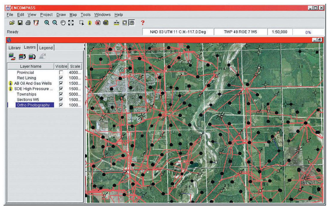
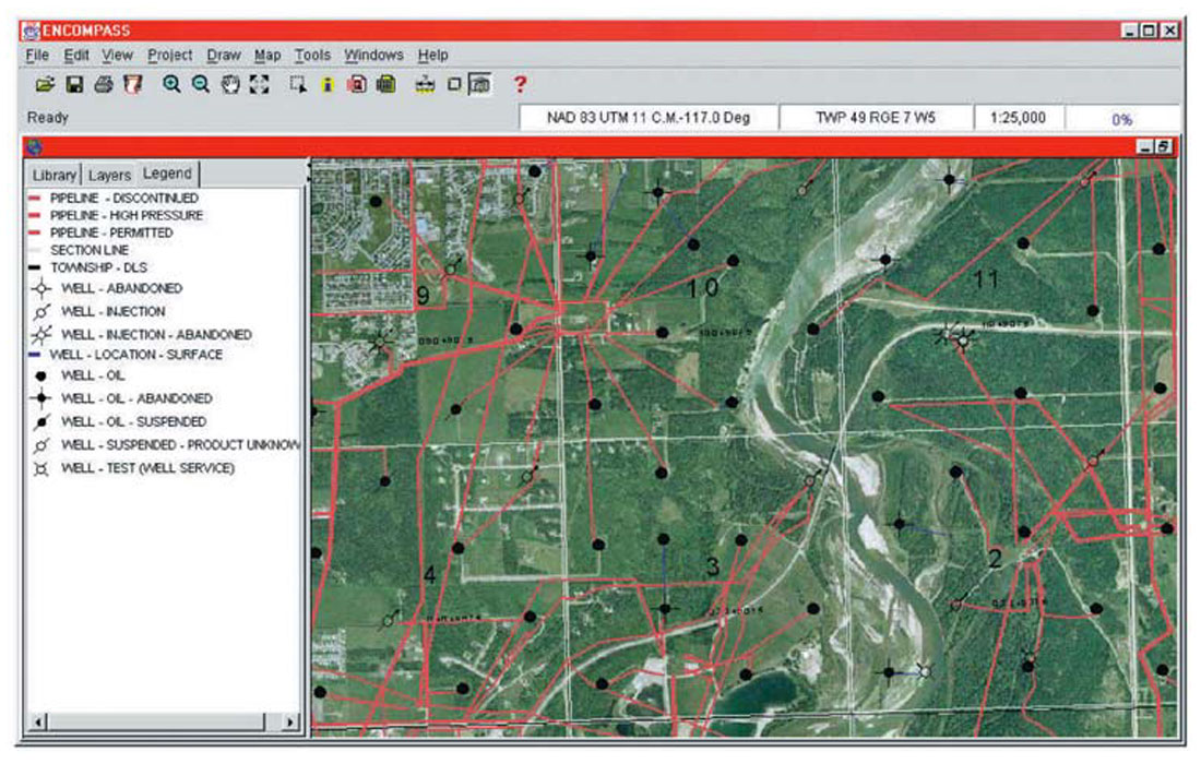
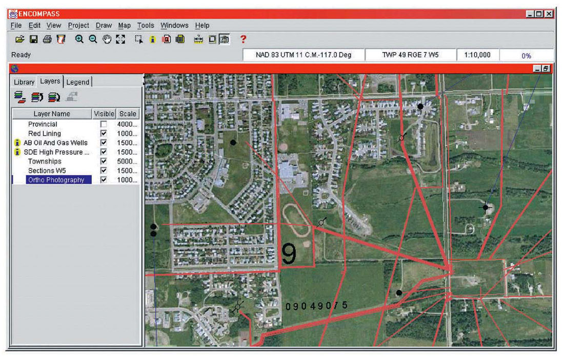
V2K aerial photography is used by the oil and gas industry to assist in planning access roads, well locations, pipeline routes, emergency response plans and seismic programs. Municipal governments incorporate V2K aerial photography as a base layer for their mapping needs to review planned developments. Agricultural service companies utilize V2K’s high-resolution aerial photography to plan spraying programs, to measure arable land area for crop damage calculations and to measure grazing capacity. Forestry companies rely on V2K aerial photography to identify harvesting areas, measure cut block volumes and plan for road access. The provincial government uses V2K aerial photography to assist in combating forest fires, review planned oil and gas activity and to monitor agricultural conditions across the province.
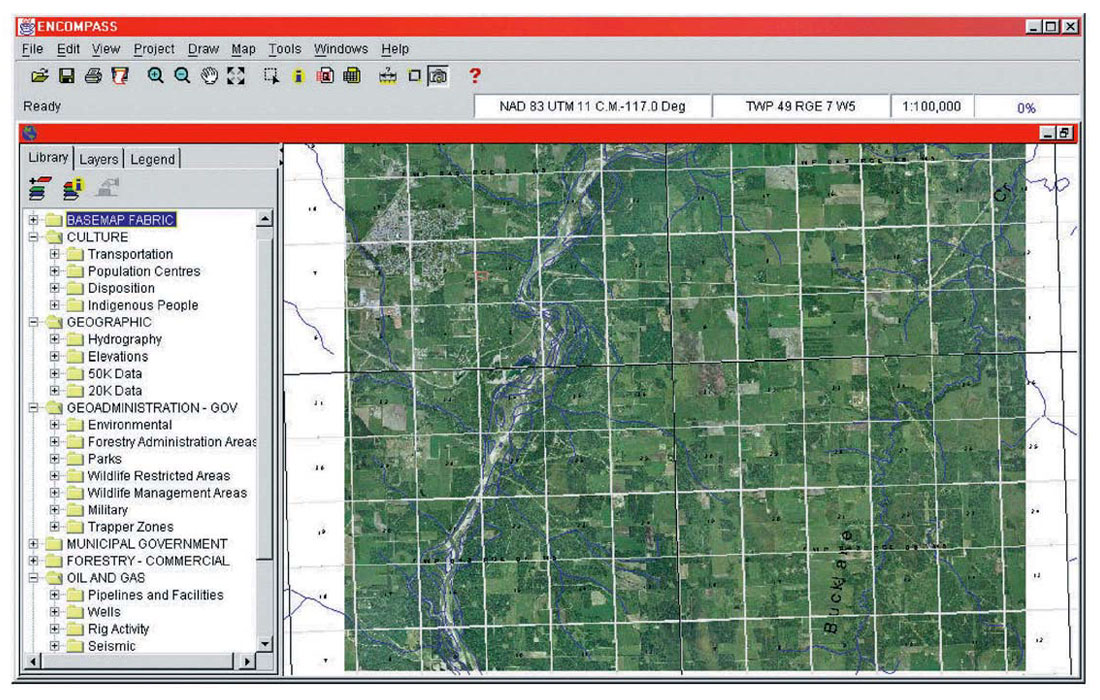
Just as the advent of seismic workstations has revolutionized the interpretation of seismic data to explore for hydrocarbons, so too has the evolution of GIS and pseudo-GIS CAD programs revolutionized the use of digital imagery for land use planning and operations. Online web-based programs are now available to efficiently access, display and download the digital imagery across the Internet without requiring high-level GIS knowledge. An internal proprietary map database is combined with the digital imagery and planning information in an interactive environment, either in an intranet system or in combination with an external database. Because V2K stores the image coordinates in a GIS system, the images are restored and delivered to other applications in a multitude of projections, eliminating the usual datum and map projection problems associated with data sharing between the oil and gas industry and other industries such as forestry and governments.
Today, the VISION 2000 library is serving its oil and gas, municipal, forestry and engineering customers with more than 2000 townships of black and white 1m ortho imagery online via the Internet. Boyd GeoMatics Ltd. and North West Geomatics Canada Inc. have teamed up to complete the V2K project by augmenting and eventually replacing the existing imagery with NWG’s newer colour orthophotography of the province over two years. The western part of the province was flown in 1999 and the remainder will be acquired in 2000.
VISION 2000 data is ordered and distributed directly from the online library at www.v2kimages.com; with Boyd GeoMatic’s ENCOMPASS Internet GIS software or through a network of value added resellers who combine the imagery with their own proprietary software.


Join the Conversation
Interested in starting, or contributing to a conversation about an article or issue of the RECORDER? Join our CSEG LinkedIn Group.
Share This Article