Thirty-five years ago, American think tank visionary Paul Rand, announced to the world a concept for a public communications network which would evolve from a communications network linking computers of academic researchers. In 1981, the term Internet was coined for this communications network that would be accessible by personal computers which came of age during the late 1970's. Then a decade later, Tim Berners-Lee created the World Wide Web. Internet usage will see a gargantuan growth to an anticipated 1 billion users by the next Millennium.
The invasion of the Internet into the workplace is moving at warp speed, altering the way organizations operate and industries conduct business. While some oil and gas companies have embraced the Internet with open arms, others have been reluctant for fear that employees spend too much time surfing and not enough time looking for petroleum plays.
Phil Ehmayer, a staff geophysicist at Canadian Occidental Petroleum is a proponent of the Internet. He has worked on projects in Nigeria where CanOxy has set up a second office. The Internet has been invaluable in providing library extracts and the latest information on Nigeria's socio-political conditions. Transferring data via the Internet is still prohibitive because of size. On one seismic survey shot in Nigeria, some of the data was transferred back to Calgary for processing via a satellite link while the bulk of the data was shipped over. "You do have to be selective about what you send by satellite," notes Ehmayer, who says the Internet has enabled him to communicate better. From the service company perspective, Rob Vestrum, Co-ordinator of Depth Imaging at Kelman Seismic processing says, "The Internet will never replace the human inter-action with service companies, nor will it replace anything the geophysicist does. It facilitates better communications and streamlines processes. If you look at the patterns of technology in the past, technology has helped the interpreter look at larger areas or enhance the interpretation. Geophysicists make better decisions, but not necessarily faster ones."
On-Line Geographical Information Systems
There is the trend for geophysical service and software companies to offer more on-line services, including accessibility of on-line Geographical Information Systems (GIS), retrieval of archived data and data brokerage. Bringing the Internet to the desktop is driven by the underlying need to get information to users more conveniently and faster. User-friendly systems have been developed so users can have direct access from anywhere to the most current real-time information available without major modifications to existing desktop equipment.
In August 1996, Strata Web was the first commercially available integrated oil and gas mapping system on the Internet. Like other GIS, Strata Web offered users a one-stop shopping experience by accessing data from leading petroleum data suppliers on the World Wide Web. Users access the Strata Web system via a browser based map and forms interface. The interface provides access to the mapping system, analysis modules and spectrum of quality data types. Quality of data on a GIS is important, and Strata Web up-dates its information databases as frequently as possible - well licenses are received daily and rig locations are received twice weekly.
The producers of this GIS, Strata Web Systems Ltd. has partnered with Geoscadd Systems Corp., International Petrodata Ltd., Nickles Energy Group, QC Data Petroleum Services, Request Seismic Surveys Ltd., Sigma Explorations Inc., Touch Tone Data and Veritas.
Like other GIS, data procured using Strata Web can be applied to a corporate Intranet model where proprietary data can be integrated with public data. The Intranet model (where the web server sits in an organization) happens behind the corporation's firewalls, and is available for internal users only.
The Veritas GOLD (Geosciences On-Line Data) browser application is a GIS which displays in a map format, oil and gas information that is stored, managed and up-dated by Veritas. Permanent virtual circuit (fiber optic) or Internet users with an appropriate password can access up to any of the 3D-plus layers of information that can be immediately displayed on their desktop. As users zoom in on a particular area, layers of information can be selectively revealed. Further detailed reports can be procured by clicking on any of the objects displayed on the map.
Neil Janssen, Senior Sales Representative for Integrated Exploration Services at Veritas GeoServices, says "Even though the Internet is a convenient fast tool to get data in an organized way, it's the information that's paramount. People should really verify the accuracy of their source of data."
This past June, Request Seismic Survey Ltd. pitched its information browser Petro-Web to the geophysical community. Used in conjunction with Netscape or Internet Explorer, Petro-Web enables users to access sub-surface proprietary and public domain data that Request Seismic has accumulated. While seismic information is concentrated in the Western Sedimentary Basin, Petro-Web is not geographically restricted and contains data from around the globe. The information is put in layers, so users can readily pick and choose their data requirements and then transfer the data on the particular area they may be working on. Users can find out where previous seismic was shot, the source types, dynamite, status of land sales and well drilling activity.
Petro-Web can be set up to be part of an Intranet, so that the information procured can be readily available for corporate users. According to Request Seismic's Chief Operating Officer, Brad Turner, Petro-Web being a web-based server allows users maximum security protection. Several users can be looking at the same data simultaneously. Once a user has set up an area of interest, Petro-Web has an intelligent agent that will send the user the latest information available. Another feature of the Petro-Web is that a "dealer room" has been set up, so visitors can post their non-core properties for sale and buyers can at least begin negotiating on-line. Turner notes positive feedback from the oilpatch for Petro-Web, which requires no hardware augmentation. Once a password is given, e-mail identification becomes the user identification.
Complimentary to Petro-Web, is Boyd Geomatics ENCOMPASS browser which is an on-line GIS for surface information that's essential for designing a seismic program - forestry, crop areas, land usage, pipeline routing, environmental and municipal activity. ENCOMPASS has been around since February 1999 and has received a lot of interest from contractors in the geophysical sector who conduct seismic surveys. In the past year, Larry Herd, President and C.E.O. of Boyd Geomatics in Calgary notes that mapping products integrating a satellite tracking component for vehicles has become popular and cost-effective with the Internet. On June 28 this year, Boyd Geomatics announced its Vision 2000 project, which is adding the company's ortho-rectified aerial photography of the province of Alberta to ENCOMPASS. This past summer, Boyd Geomatics added its Municipal Information System to its ENCOMPASS platform as well.
This month, Geo-Syn software is releasing its on-line web server application that enables users to create their synthetic seismograms on-line. That which previously could take up to a day to create, can now be created within 60 seconds. By clicking on a well interface on a map, users can select a digital log curve, whether it be sonic, density or gamma. The information from the digital log is then transformed into a seismogram.
Internet Security
Geophysical suppliers estimate less than one-half of geophysicists are using the Internet on the job for their work. "Our concern is not that you can do all those wonderful things on the Internet, but what about viruses?" asks Barry Wilmot from Canadian Ceja Corporation. A geo-scientist at a relatively small oil and gas company, Wilmot explained that a conscious decision was made by Canadian Ceja two years ago to replace its old computing system with a local area network. One computer is a standalone unit for receiving and sending e-mail, and is not part of the LAN. "Sure you can buy those firewalls, from cheap to expensive, but lately, you do hear more and more about viruses. The hackers never have known anything about the Cold War, but they sure know about computers. It just takes them a few seconds to change the code on something. It's intuitive to them. Our concern is that if a virus got into our system, we would lose all our financial, geophysical and geological data. We don't have a big IS department. With us, we can't afford to be down," explains Wilmot.
In the past, a computer program had to be opened to hatch a virus, but nowadays, viruses can be transmitted via e-mail messages. Once the user opens the attachment, there's enough impetus to run the program that releases the virus. There are some 300 computer viruses discovered monthly, most of which can be transmitted bye-mail attachments. Hackers also program viruses to replicate on the Internet, which inevitably hinders the speed of traffic along the digital highway.
In April 1999, two dreaded viruses cannibalized computers worldwide. The Melissa virus masquerading as an innocent e-mail message attacked corporate networks and Chernobyl virus arrived as an executable file that made sure computers failed to start.
Viruses can also be found attached to files downloaded from the Internet. For further information on viruses, check out these web sites - AVP Virus Encyclopedia at www.avp.ch/e/avp-news.htm. Norton Anti-Virus at http://www.symantec.com/avcenter/index.html. McAfee Anti-Virus at www.mcafee.com and Virus Expert Doug Muth at www.claws-and-PQs.com/virus/index.html.
Fortunately, most geophysical applications are run on UNIX, which is a little more viral resistant, as hackers prefer Windows-based systems. Still, precautionary measures are being taken by corporations to protect themselves. Firewalls are hardware and software dedicated to blocking unauthorized information transfer. They only allow certain types of traffic from the Internet to enter a corporate Local Area Network (LAN). True enough, hackers can still figure a way to find a portal through the firewall, but like a home security alarm system, the presence of the firewall makes it harder for the hacker to get in. Without a firewall, hackers can try entering the LAN via e-mail or the corporate web server. Firewalls however, do monitor the Internet and can be costly to maintain.
Besides viruses, security of the Internet is another bone of contention. Being a public infrastructure, the Internet has no police or watchdogs. Even phone lines or direct connections, like MetroNet, are more secure. To provide more security, web servers are often used. Many oil companies have all their e-mail directed to a web server before being re-directed internally. Firewall protection is provided prior to entry at the web server. Traffic between the web server and the end user is encrypted, so the message is harder to interpret. Some organizations with two offices in two different cities are installing virtual private networks where two computers are set up at either end of the connection, like a secure web server. Packets of information are encrypted when transmitted and then de-crypted at the other end. Firewall protection is provided at both ends.
Seismic Data Transfer
The large amount of seismic data required to be transferred raises the question as to what's the most effective and economical means of shipping data around amongst the field, processor and client. Couriering over a magnetic tape has been the most traditional, dependable means, but not the most timely. Transport of data via Internet, fiber optic networks, and satellite, all have their advantages and disadvantages. With the Internet, security and limited bandwidth capacity are two prevailing concerns. Internet bandwidth of up to 1 megabit per second can be reasonably acquired. Proponents of data transfer via the Internet often suggest that only small files be sent, like final images, with the co-ordinates of the data left out for security measures.
Fiber optics can provide the bandwidth that seismic data users require, although corporate computers require some modification to accept the high-speed broad band information. With a fiber optics link to service providers like MetroNet, Shaw or Telus Advanced Communications, permanent virtual circuits (PVC) can be set up. Liam Christie, Vice-President for Data Sales at MetroNet states that no network is foolproof. The VPC is a lot more difficult to break into than the Internet. The PVC could transmit data as slow as the traditional Local Area Network of 10 megabits per sec or as fast as 30 megabits/second.
Stack and field data can consume terabytes of data (1 terabyte is equal to 1,000 gigabytes). The entire seismic data collection for any intermediate sized oil company may range from three to six terabytes with the average 2D Western Canadian Sedimentary basin seismic line in the neighborhood of 280 megabytes of data. With PVC access to archived data, geophysical managers, data managers and other expIorationists can manage their data from their own desktop.
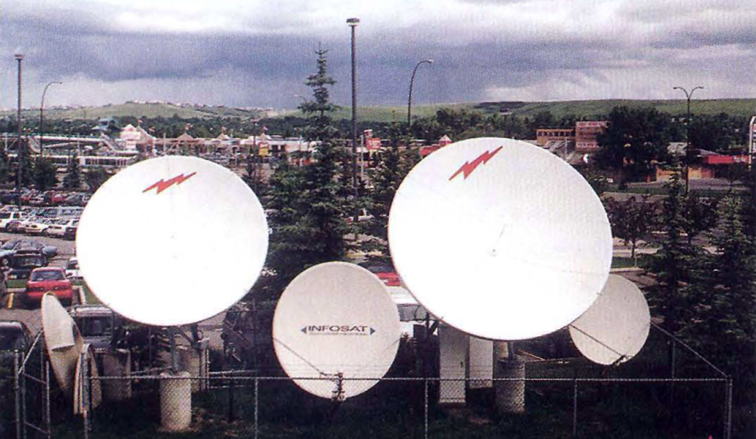
In remote areas, especially on seismic survey ships, tropical jungles, or in remote locations in Northern Alberta, satellite data transmission is the only option to send data in a timely manner. Two-way satellite communication is comprised of five components through which the data has to pass during its transport. According to Dale Gamber, sales representative for Infosat Communications in Calgary, in order to effectively hack into a satellite system, all five components must be broken into. Satellite speed is typically rated at 3 megabits/second. Increasing bandwidth capacity is technically feasible, but for the most part, cost prohibitive.


Join the Conversation
Interested in starting, or contributing to a conversation about an article or issue of the RECORDER? Join our CSEG LinkedIn Group.
Share This Article