Summary
The Beaufort-Mackenzie basin in Arctic Canada is a petroliferous province still in the early stages of exploration. Almost three decades of exploration in the Mackenzie Delta onshore and shallower water offshore have resulted in 48 conventional oil and gas discoveries. Although no significant production exists as yet, mean undiscovered resources in the basin have been estimated at 16.8 billion barrels (2.7 billion cubic meters) by the Geological Survey of Canada (Chen et al, 2007), inclusive of deep water (to 2,500 m), and at 14.5 billion barrels of liquids (2.3 billion cubic meters) and 86.6 trillion cubic feet of gas (2.32 trillion cubic meters) by the United States Geological Survey (USGS, 2006), exclusive of “deepwater” (>1,000 m).
Despite major questions about the petroleum system, the results of recent bidding demonstrate that industry recognizes the deep-water potential of the basin. In 2007, Imperial and Exxon-Mobil bid Can $585 million on one of the deepwater blocks; this was followed by a Can $1.18 billion bid by BP on an adjacent block in 2008 (Indian and Northern Affairs, Canada, 2007, 2008).
To expand the knowledge of the basin architecture, GXT acquired ~3,500 km of 2D long-offset seismic data in the area in late 2006 (Phase I). Building on the success of Phase I, another ~5,500 km of data was acquired in 2007 (Phase II). A third phase of survey is taking place in the summer of 2008. Cognizant of the deep-water potential, we have attempted to extend the lines as far west and north in the open water as ice conditions and environmental considerations have allowed in each season. These programs have been designed to image down to the base of the crust with a 9-km long cable, 18-second recording, and final depth processing (prestack depth migration) to 40 km. The new data are interpreted to regionally map the ocean-continent boundary and the top of MOHO discontinuity, then tied to existing well data to identify the major stratigraphic sequences formed since the opening of the Canadian Basin.
Highlights of interpretation include:
- The offshore Mackenzie Delta system contains almost 15 km of sediments; in areas outside the delta system, the Late Mesozoic-Tertiary sedimentary wedge is still 8-10 km thick at the shelf edge and upper slope;
- Complex folds (earlier interpreted as “diapirs”), faults and thrusts formed due to interaction of compressive folding, wrenching, extension, inversion and gravity-induced loading, all operating at the same time in distinct segments of this region;
- A series of large, late-Tertiary structures occur in the offshore part of the delta extending to water depths of >1,000 m;
- Gas chimneys and amplitude anomalies in the seismic data are widespread indicating a very active petroleum system; and
- The ocean-continent boundary and oceanic crust, with an extinct spreading center, are mapped beneath the delta sediments, but the nature of the crust underlying the deepest part of the basin remains uncertain.
Introduction
Although exploration in the Beaufort-Mackenzie Basin began almost three decades ago, and despite a series of discoveries, commercial production remains elusive. The Geological Survey of Canada (Chen, et al, 2007) and the United States Geological Survey (USGS, 2006) have made recent resource assessments of the area. They conclude that the potential is significantly larger than the results to date imply. A single, very large discovery is needed to provide the economic incentive to build the infrastructure for oil production in the area. Existing discoveries could then be tied to this “anchor” discovery (Johnston, 2007). The critical question, therefore, is whether that supergiant field exists in the unexplored outer shelf and upper slope.
The existing well data in the area confirm a working petroleum system, but some aspects of the geological history of the basin have not been fully defined; for example, the details of the crustal structure, the nature and location of the ocean-continent boundary, and the geometry and timing of events in the Beaufort fold and thrust belt. The legacy seismic data are largely confined to the middle and inner shelf, and, although some deep reflection and refraction profiles have been acquired in the area (Stephenson, 1994), most data penetrate to “exploration depths” (12 km or so). Additionally, the offshore wells are located only in the shallow (<50 m) parts of the Mackenzie Delta, and, because of the thickness of sediments, well penetrations into sequences older than Eocene are rare.
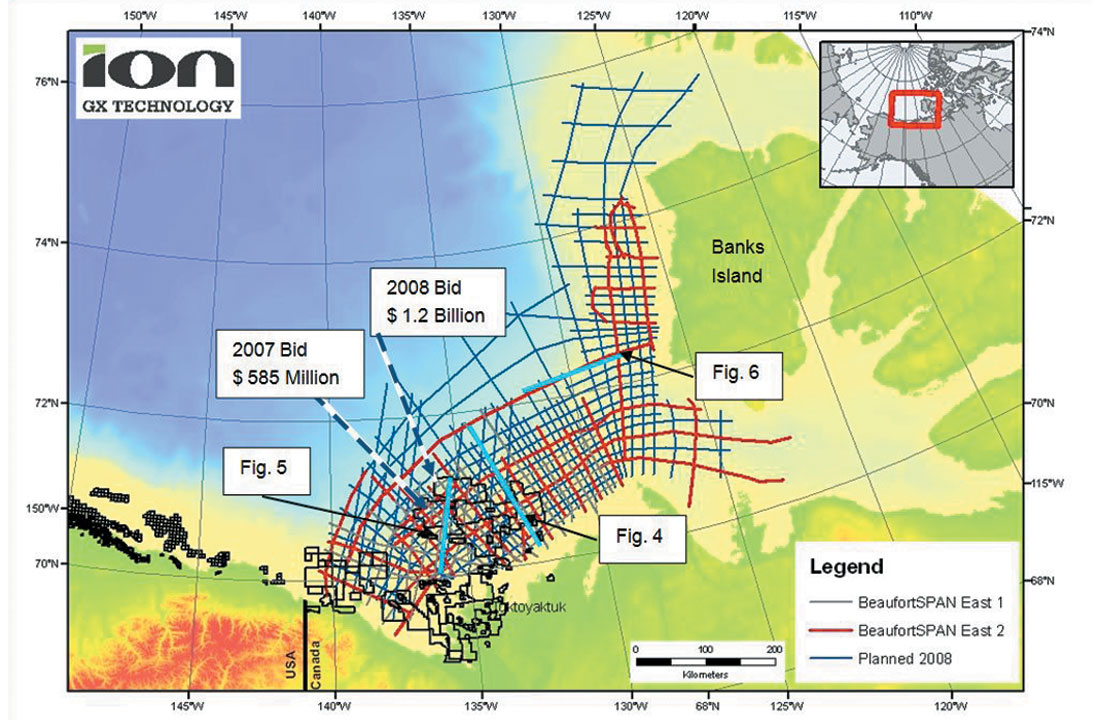
The BeaufortSPAN East program extends along almost 800 km of Mackenzie Delta, the Canadian Arctic Islands margin and up to 200 km offshore to provide a consistent regional image of this margin (Figure 1). The Phase I data were acquired in Aug.-Oct. 2006 with a shotpoint interval of 50 meters, receiver interval of 25 meters and a sampling rate of 2 ms. The final processed data are 90 fold and have undergone Kirchhoff PSDM (prestack depth migration) to 40 km. The Phase II program was acquired in Aug.- Oct. 2007 with the same parameters. The third phase is expected to be acquired during summer 2008 and will be processed by early 2009. By the end of 2008, we expect to have acquired almost 15,000 km of Canadian Beaufort Sea data with these parameters.
The data provide images down to the top of MOHO along most of the lines, and, at the same time, provide stratigraphic and structural details in the upper 12 km. Although our interpretations are regional, they shed light on the crustal framework, sedimentary-wedge geometry, and evolution of the Mackenzie fold and thrust belt, as well as primary sediment fairways. This allows a more comprehensive evaluation of the petroleum system of the basin than has been hitherto possible. Although detailed technical discussion is beyond the scope of this paper, our objective is to list and display some of the highlights of the interpretation.
Interpretation of SPAN Seismic Data
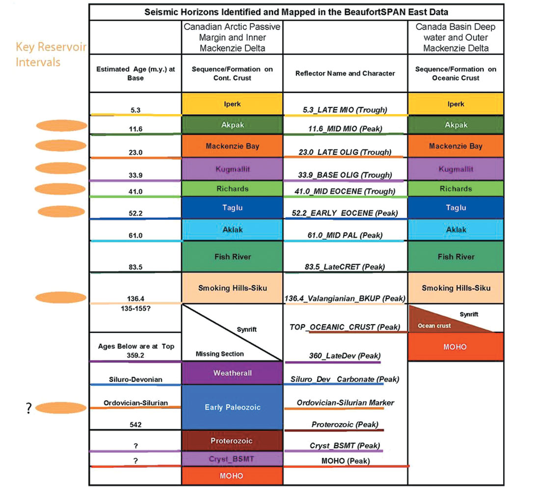
Figure 2 displays the major sequences identified in the Beaufort-Mackenzie Basin (Dixon, 1996) and the horizons we have interpreted in the study area. The seismic events identified have been tied to the existing well data. Regional ties have been extended beyond the well control. There are no well ties available in the Banks Island area. In the Amundsen Gulf area, south of Banks Island, we have relied on surface geology (Wheeler and others, 1996) to identify the seismic events close to the sea floor. As mentioned earlier, correlation of seismic reflectors older than Taglu (52.2 m.y., Figure 2) are not based on well ties but are primarily based on regional structure and stratigraphy and published information. Interpretations of oceanic crust, crystalline basement and the top of the MOHO are consistent with published work (Stephenson, et al., 1994) as well as potential field data.
Although, contrasting views on the opening of the Canadian Basin have been presented (Lane, 2007, Grantz, 2007), SPAN data optimally support a rotational opening of the Canadian Basin and extension of the “paleo-spreading center” near the mouth of the Mackenzie River. We identify a passive margin boundary of the Canadian Basin, extending along the Tuk Peninsula and Banks Island, whereas the continuation of this passive margin into the Alaskan Beaufort Sea is masked by the immense thickness of Mackenzie Delta sediments (Figure 3). This figure shows an interpreted Continent-Ocean Boundary (COB), a potential extension of Canadian Basin spreading center under the Mackenzie Delta and a few lineaments observed on the gravity map that could be interpreted as fracture zones.
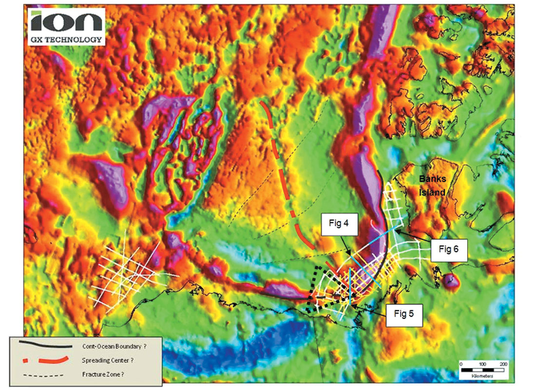
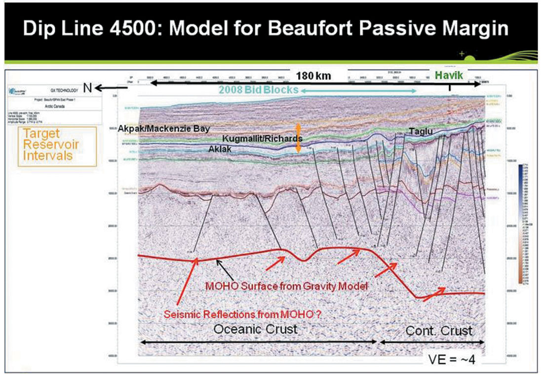
As shown in Figure 4, towards the north, the ocean-continent boundary is well defined as a fault, and the interpreted MOHO, calculated from gravity data (red horizon at depth), is significantly deeper below the continental crust. Seismic events consistent with the gravity-derived MOHO are observed on SPAN data. The horizon colors approximately match the colors shown in Figure 2.
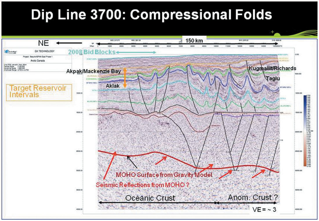
In the region of the Mackenzie Delta, as shown in Line 3700 ( Figure 5), the structural style changes dramatically to form the Beaufort Foldbelt. Gravity sliding and Brooks-Range compression from northeastern Alaska have created folds and thrusts with a master detachment level of almost 15 km in southern and western parts of the area. A younger, late-Tertiary, compressional event caused structural inversion, folded the master detachment surface and created a large structure at the shelf edge which extends into deeper waters. This inversion structure is located where we have postulated the presence of a now-inactive spreading center under the delta sediments and where others (Lane, 2002) have suggested the presence of the Continent-Ocean Boundary.
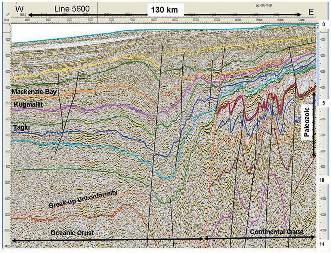
The SPAN data also show that, outside the Mackenzie Delta area, the total sedimentary wedge above the Breakup Unconformity is still significantly thick. As shown in Figure 6 (located on Figures 1 and 3), this wedge is considerably thicker than previously believed. In addition, at the southern edge of Banks Island, this line displays a major rollover feature, showing a landward dip of all the Mesozoic and Tertiary horizons. As interpreted here, the Continent-Ocean Boundary is located almost 20-35 km landward of this rollover feature. The full extent of this feature is not mapped, but it is almost 30 km wide, and the structural relief, at the horizon marked as the top of “Mackenzie Bay” sequence, is almost 800 m.
These examples show that the crustal structure of the Canada Basin and its tectonic history are directly related to the structure and stratigraphy that is reachable through exploration. Therefore, any reconstruction of basin evolution needs to take into account the fundamental crustal structure and its influence upon the geometry and timing of deformation from the initial rifting to the most recent tectonic events.
Conclusions
- Reflectors ranging in age from 5.3 million years to the Proterozoic are identified in BeaufortSPAN East Phases I and II data.
- Along most of the margin of the Beaufort Sea, iterative seismic and potential-fields interpretations constrain the location of the Continent-Ocean Boundary along the Canadian Arctic margin. However, the crust under the central part of the Mackenzie River sedimentary wedge is difficult to characterize due to the thickness and folding of the sediments, but the crust does appear to include the buried spreading center of the Canada Basin.
- Asyn-rift sedimentary wedge, consisting of 1 to 3 km of mixed pelagics and clastics, was deposited between 150 and 136 million years ago.
- Multiple phases of thrusting and folding are evident; the phases were active from the Early Tertiary to the Late Miocene. The compression that was responsible for the thrusting also produced wrench and extensional structures in some areas. The master detachment surface for the thrusts appears to be located near the base of the sedimentary column at a depth of approximately 15 km.
- Most of the reported “diapir-like” features in earlier literature are not true diapirs because steep internal layering can be observed in the cores of anticlines in the SPAN data.
- Exploration opportunities exist in numerous fold structures in the unexplored outer shelf and upper slope as well as in the untested deeper parts of the sedimentary section under the inner shelf. In addition, there are ample opportunities for stratigraphic exploration in the area, although syntectonic growth facies and unconformities (Dixon, 1996) make it a challenging endeavor.

Acknowledgements
We gratefully acknowledge various scientists of the Geological Survey of Canada, especially Tom Brent, Zhuoheng Chen, Ashton Embry, Chris Harrison, Larry Lane, and Kirk Osadetz for providing data and information on the geology and petroleum potential of Beaufort-Mackenzie basin and for discussing with us the complexities of the Canada Basin history and tectonics.


Join the Conversation
Interested in starting, or contributing to a conversation about an article or issue of the RECORDER? Join our CSEG LinkedIn Group.
Share This Article