A most recent fiber-optic based technology that has been adopted in VSP acquisition is distributed acoustic sensing (DAS), where the fiber-optic cable in the well is the sensor and a typical seismic source is shooting on the surface into the reservoir formation. This technology enables a fiber-optic cable to be used as a massive acoustic sensor array in VSP applications. In BP, we use fiber-optic cables originally deployed in our wells for pressure and temperature gauges to turn our wells into giant sensing antennas to image and monitor our reservoirs. This paper presents the results from various DAS VSP field trials in Alaska, Trinidad, and Gulf of Mexico that demonstrate the success of using DAS for structural imaging and reservoir delineation.
Introduction
Seismic imaging and time-lapse reservoir monitoring can give us critical information to guide placement of production and water flood injection wells in our high-value reservoirs. However, below salt and other complex overburden, surface or seabed seismic may not give us the required resolution of fine-scale reservoir architecture. Also, the signal-to-noise ratio (S/N) in time-lapse seismic is often poor due to two-way travel through salt.
Placing large receiver arrays permanently in wells below the overburden salt has the potential to deliver the required resolution and enable efficient time-lapse monitoring of the reservoir. However, permanent instrumentation of wells with large seismic arrays is not possible with today’s conventional technology. Can we use simple fiber-optic cables, already deployed in producing wells for downhole gauges or cabled in new wells, to perform high-resolution seismic imaging and monitoring of our reservoirs?
The concept is extremely attractive, and is implemented simply by deploying a special optical interrogator unit enabling the seismic distributed acoustic sensing (DAS) concept attached to optical fiber installed in a well. The energized fiber-optic cable then effectively transforms the entire length of the fiber into a large array of seismic sensors. With signals generated by surface seismic sources and received by multiple wells, data can be acquired to achieve an imaging and monitoring prize otherwise not possible.
DAS is a relatively recent development in the use of fiber-optic cable for acquiring borehole seismic data. Its major advantages are low cost, ability to create large arrays and simplicity of deployment. Compared to conventional borehole seismic application using geophones, DAS does not require installing a complex instrument into the wellbore, and can use any existing fiber-optic cables permanently installed in the well, such as those used for pressure/temperature (P/T) measurements and other monitoring purposes. However, DAS development for borehole seismic application is still at a relatively early stage. The major drawbacks of DAS are the high noise level, poor transverse sensitivity, and difficulty to determine the exact position of virtual DAS channels. But its unique functionality will undoubtedly find more and more seismic applications though will require the emergence of appropriate DAS system upgrades.
In 2009, Shell introduced DAS as a new method for VSP acquisition (jointly developed by Shell and OptaSense) and performed their first onshore field trial of DAS for geophysical monitoring in Canada (Mestayer et al., 2011). And through this field trial, the proof of concept for DAS as a tool for recording downhole seismic from active sources was provided. Later on, two additional field trials were carried out in Shell assets onshore Canada and USA throughout 2010. In late 2012, a dual-well 3D DAS VSP survey was simultaneously conducted by Shell with OBS survey in deepwater Gulf of Mexico, and the feasibility of DAS in deepwater with a 3D VSP in an operating field was proved (Mateeva et al., 2013).
In order to explore as well as evaluate the DAS technology in BP, we have executed various DAS VSP field trials in several locations around the world (Li et al., 2013; Zhan et al., 2015). Successful gathering of data with large borehole arrays was achieved in production wells in three fields – one in onshore Milne Point Field, Alaska; one in offshore Mahogany Field, Trinidad; and the other in offshore Mars Field, Gulf of Mexico. In this paper, we show the DAS data collected and corresponding imaging result from each field trial. Taking together, these field trials demonstrate many benefits and potential applications of DAS technology in terms of new seismic acquisition, and the business impact on reservoir imaging and surveillance is significant.
DAS VSP Field Trials
Alaska field trial
We first performed an onshore borehole seismic survey at Milne Point Field, Alaska (Figure 1a) in 2012. Both geophones and hydrophones were placed in the well at 16 depth locations with a 30 ft receiver spacing, ranging from 50 ft to 500 ft deep. Vibrators generated seismic signals with a 60 ft source spacing (Figure 1b). There were 8 sweeps at each source point. Each sweep time was 12 s long and the receiver listening time was 16 s. The correlated signal was 4 s long and the DAS data (acquired by Silixa) had the same recording time as the geophone data. The DAS implementation of this field trial treated each 1 m segment of cable as an individual receiver resulting in a total of 143 virtual DAS receivers.
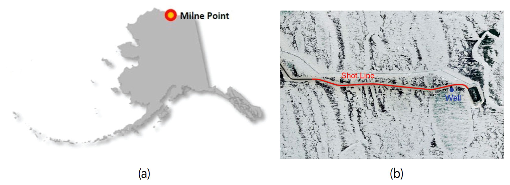
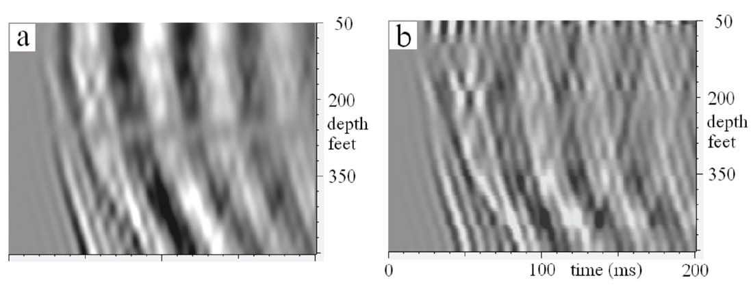
Figure 2 compares the interpolated geophone (16-level) Z-component data with the DAS (143-level) data, where the source is 223 ft away from the wellbore. The data shown here is from 0 to 200 ms, where the noise level is relatively low. Both downgoing and upgoing waves are clearly seen in the DAS data. Besides, the relative amplitude, phase, and frequency of DAS data all look as similar as those of the geophone Z-component data.
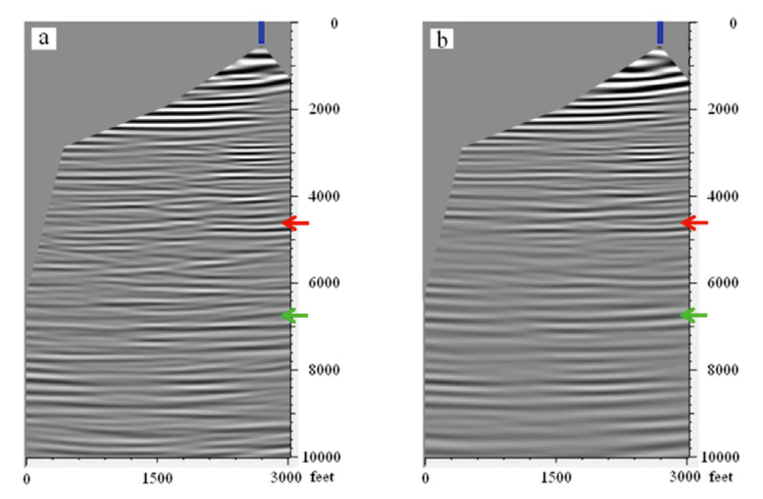
Both DAS data and geophone data were then migrated using reverse-time migration (RTM) with a maximum frequency of 35 Hz, and the migration images are shown in Figure 3. The migrated DAS image (Figure 3a) is similar to the image of geophone Z-component data (Figure 3b), especially below the well and above 5000 ft. Besides the similarity, the DAS image is slightly noisier and more swing noises are observed at the depth lower than 4000 ft.
Trinidad field trial
We then looked for field trial opportunities in offshore BP wells already instrumented with suitable fiber-optic cable with active seismic operations nearby. In 2013, we went to Trinidad where a large ocean-bottom cable (OBC) survey was being acquired near the well in the Mahogany Field with instrumented fiber suitable for the technology. Figure 4 shows the survey location as well as the source-receiver geometry information.

The opportunity to acquire this survey using one of the OBC shooting vessels was provided during a planned move of the OBC cables. In May 2013, with surface seismic shooting vessel provider (WesternGeco) and DAS provider (Silixa) we acquired data in the 3.1 km deep production well. Using an optical interrogator unit on the surface platform powering the lead-in cable for a bottom hole fiber-optic P/T sensor module, we created 1800 borehole seismic sensors with 2 m spacing, fully instrumenting the well, and 4000 shots were fired by the surface seismic vessel. The large borehole array was enabled simply by temporally swapping out the surface P/T interrogator unit with the DAS interrogator unit, with no impact on the well.
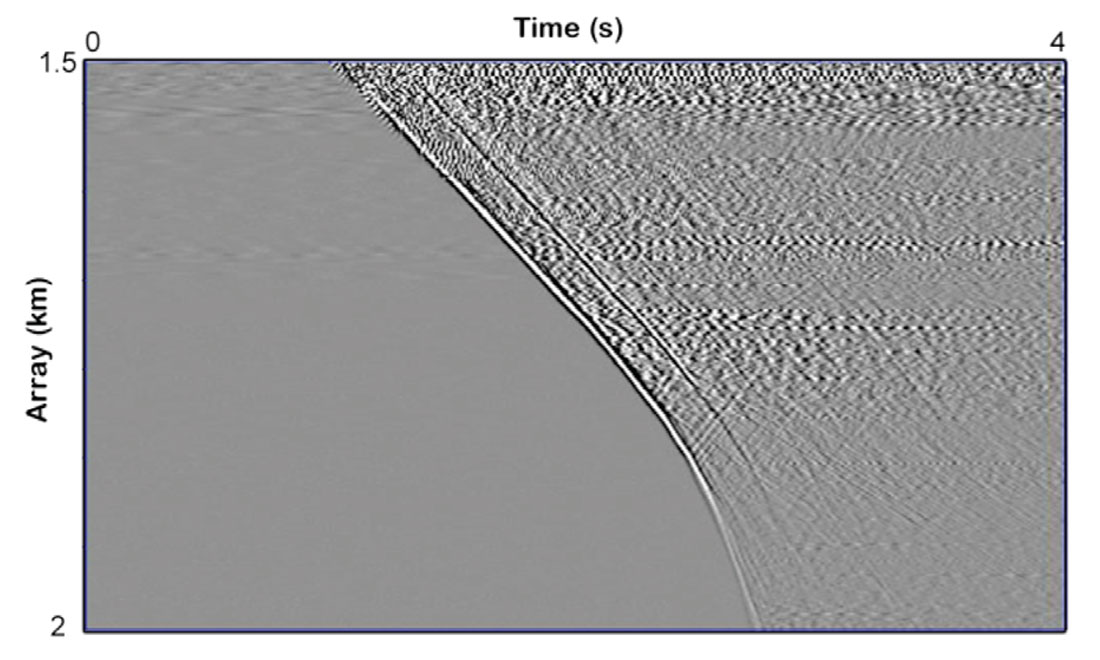
Figure 5 displays a representative shot gather recorded by using the lead-in fiber-optic cable. The S/N is excellent, and strong first break yields VSP arrival times and full-waveforms that are easy to analyze. The resulting DAS image is shown in Figure 6. For an apples-to-apples comparison with OBC and DAS, we decimated the 3D OBC data to input the same shot points as the DAS VSP and the corresponding OBC image is presented in Figure 6 as well. Analysis of the Trinidad DAS data demonstrated an image of the subsurface comparable to the OBC image acquired at the same location, and also with resolution of additional features that complement the OBC.

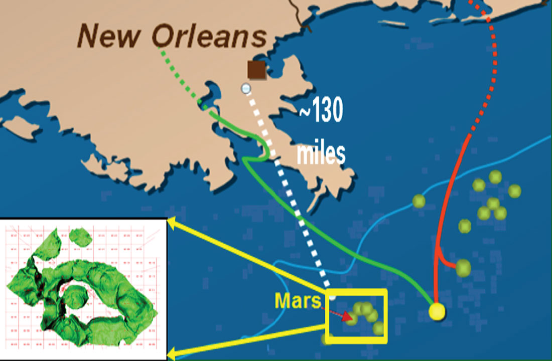
Gulf of Mexico field trial
In 2013, we entered into an agreement with our co-owner Shell to use their 3D DAS data (acquired by OptaSense) in the Shell operated Mars Field in Gulf of Mexico (Figure 7a). Data had been acquired in 2012 in two wells simultaneously with OBN data using a surface source vessel (Figure 7b). Details can be found in the paper by Mateeva et al. (2013) and Wu et al. (2015).
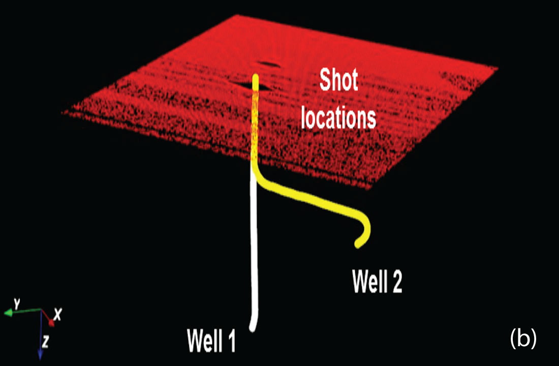
The 549-level DAS data from the vertical well and the 790-level DAS data from the horizontal well are plotted and compared in Figure 8. The S/N and data quality of the two datasets are quite different due to poor transverse sensitivity of fiber-optic cable in the horizontal well.
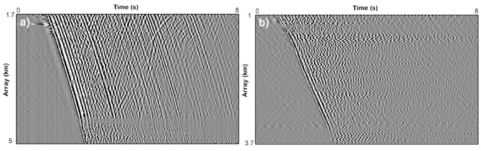
Figure 9 compares migration images provided by 3D OBN and 3D DAS VSP using the same tilted transversely isotropic (TTI) model. It is clear that DAS VSP (Figures 9b and 9c) with large borehole arrays offers a comparable local image as that of OBN (Figure 9a). In addition, DAS VSP gives an imaging product with improved image quality of reservoir targets as well as better extra-salt illumination.

Discussion and Conclusions
Successful DAS data with large borehole arrays have been acquired in production wells. Our analysis of the DAS data clearly shows imaging results both comparable to and higher image quality than the surface or seabed seismic images.
Success of the field trials paves the way to work towards multiple options. The potential business prize is huge – understanding fine scale structure, reservoir compaction and the movement of reservoir fluids through time-lapse monitoring are but a few examples of how DAS technology will impact the surveillance plan of our fields. With results of the field trial data collected, we are preparing guidelines on limitations and application of current technology.
Although there are a lot of potential options of using DAS for seismic imaging, we also observed a few main challenges and issues of DAS during processing which may limit its applications. The first one is its high optical noise floor, which is normally 20 dB – 30 dB over conventional VSP geophones. The second one is the directional sensitivity of fiber-optic cables and the drop of DAS transverse sensibility is faster than that of geophone (approximately cos2 versus cos). The last one is depth uncertainty of DAS channels so that depth calibration is important especially for long deepwater wellbores. These issues will cause great difficulty in using DAS data for reservoir structural imaging. Therefore, interactions with DAS vendors for required upgrades of interrogator unit and fiber-optic cable are necessary to deliver major business value.

Acknowledgements
We would like to thank BP and Shell for support and permission to publish this work. Computing support and resources were provided by BP’s Center for High Performance Computing. Silixa acquired the DAS data for the Alaska field trial and Trinidad field trial and data are owned by BP. OptaSense acquired the DAS data for the Gulf of Mexico field trial and Shell owns the data.


Join the Conversation
Interested in starting, or contributing to a conversation about an article or issue of the RECORDER? Join our CSEG LinkedIn Group.
Share This Article