This article documents a recently-initiated, collaborative study of seismicity in northeast British Columbia. Induced seismicity is a topic of increasing, and global interest, in particular with respect to shale-gas extraction activities. There are many important questions regarding linkages between induced seismicity and hydraulic fracturing (HF) activities. Addressing these questions requires robust datasets, including earthquake catalogues and three-component broadband seismic waveforms. Here, we describe the historical datasets available for understanding the background seismicity of northeast BC (NEBC), the deployment of new seismic stations in the area, and the resulting improvements in earthquake monitoring capability.
Our preliminary investigations show an increase in both the number of small earthquakes, and a slight increase in the average magnitude of earthquakes in regions of NEBC experiencing HF activities. Deployment of additional seismic stations in mid-2013 has substantially enhanced the monitoring capability, lowering the earthquake detection threshold from ~ M 2.5 to ~ M 1.5. This has resulted in a ten-fold increase in the number of M< 2.5 earthquakes recorded, from 14 for the 4-year period of 2009-2013 to 186 for the one-year period between August 2013 and August 2014. As additional seismic stations are deployed in the neighboring regions (Northwest Territories and Alberta) and additional data are collected, much better constraints on precise earthquake locations and depths will become available, and will help to answer the numerous key questions related to HF and related seismicity.
Introduction
There is significant global interest in induced seismicity associated with HF activities (e.g., Green and Styles, 2012; Hayes, 2012). There are many outstanding questions, including: Are induced earthquakes associated with the HF process, or with the injection of waste water into deep disposal wells? How large can these induced earthquakes be? Is the rate of seismicity (and magnitude) related to the injection pressures or the volume of injected fluids? What is the role of local faults, fluids, and the local stress regime? Answers to these questions will provide the sound science required by regulators, decision-makers, and industry to help guide this new resource.
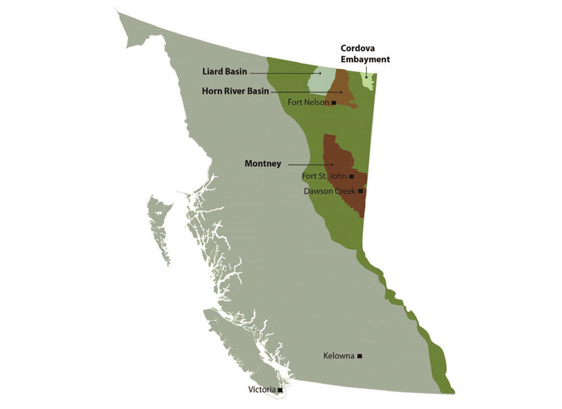
Of all the shale gas basins in Canada (US Department of Energy Report, 2011), those in NEBC – e.g., the Horn River Basin and the Montney trend (Figure 1), are the most active in Canada in terms of shale gas production. This makes NEBC the ideal region in Canada to examine potential linkages between HF processes and induced seismicity. Furthermore, HF began relatively recently (2006), and in some areas has increased rapidly, and in other areas has slowed down (British Columbia Oil and gas Commission Report, 2012), thus allowing for temporal and spatial changes in seismicity as related to temporally- varying HF activities.
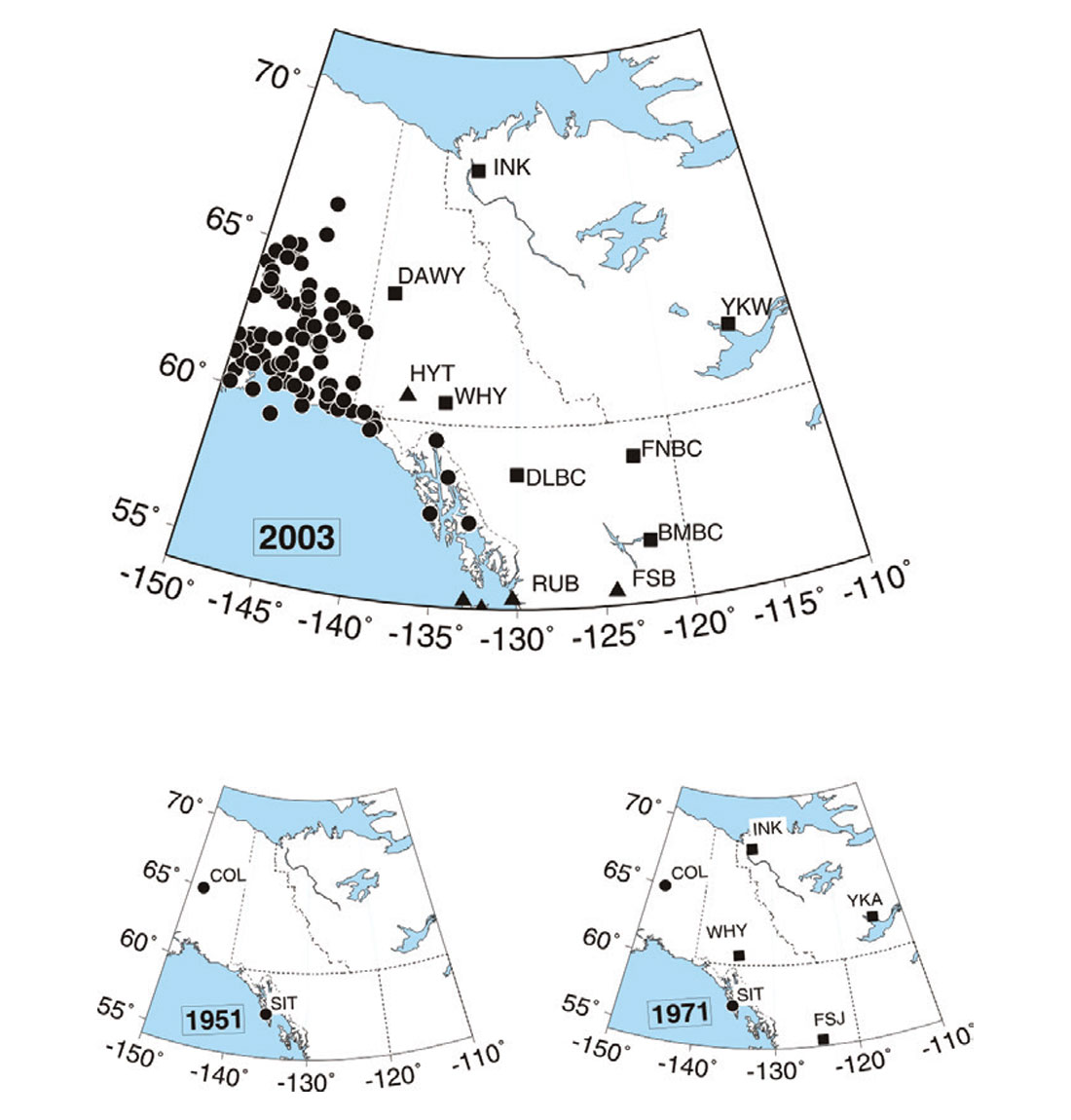
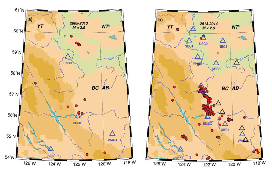
One of the challenges in NEBC (as in many regions of the world) is the limited monitoring of earthquakes due to relatively few seismic stations (Figure 2). Distinguishing background tectonic seismicity from induced seismicity (e.g., Horner et al., 1994; Deichmann and Giardini, 2009; Frohlich et al., 2011; Holland, 2011; Avouac, 2012; Frohlich, 2012; Ellsworth, 2013; Frohlich and Brunt, 2013; Maxwell, 2013) is often a challenge. In addition, a lack of nearby seismic stations makes seismicity depth constraints exceedingly challenging, thus limiting the ability to link seismicity with specific human activities.
In this article we describe a collaborative study to examine seismicity in NEBC, the determination of background tectonic seismicity, and some preliminary results between low-level seismic activity and HF activities.
Data and Analysis
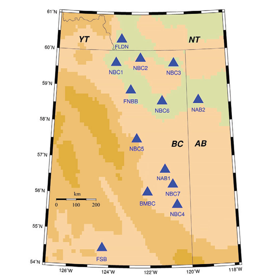
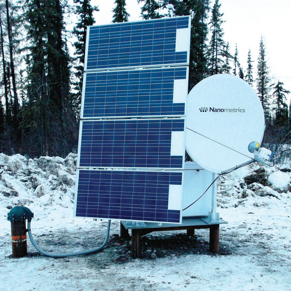
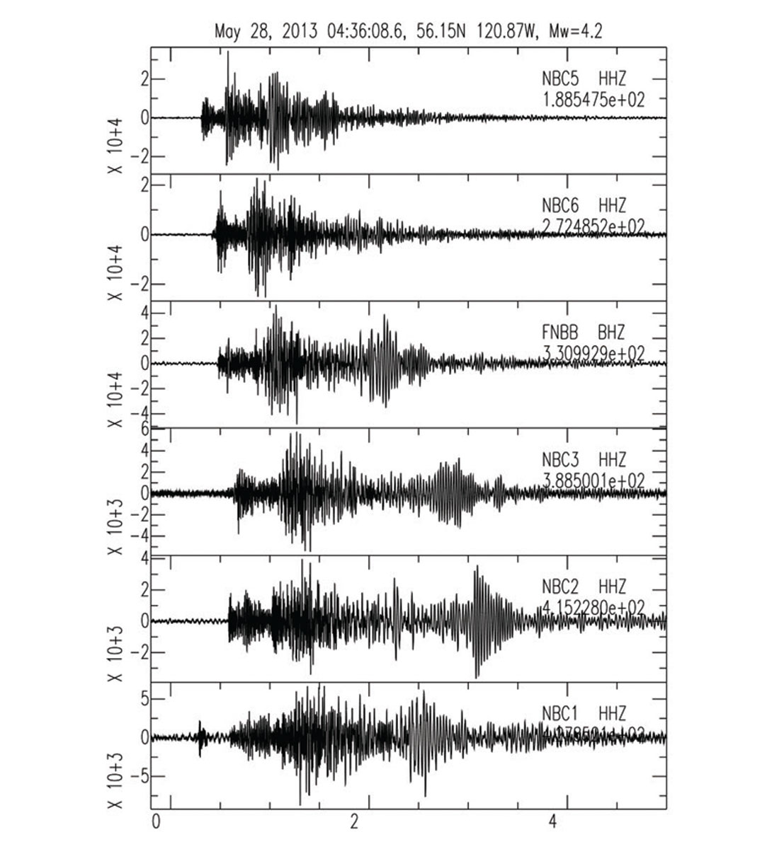
This research began in 2012 as a partnership between the BC Oil and Gas Commission (BCOGC) and Natural Resources Canada (NRCan), Geological Survey of Canada – Pacific, to examine potential linkages between HF activities in NEBC and seismicity. Initially, the key data to be analyzed were the seismic waveforms recorded by stations of the Canadian National Seismic Network (CNSN) and the national earthquake database maintained by NRCan. However, it was clear that to make substantial advances in the science and understanding of induced earthquakes, additional seismic stations were required to improve location accuracy and reduce detection threshold. Geoscience BC (GBC) and the Canadian Association of Petroleum Producers (CAPP) jointly provided more than $1M in funding to deploy 6 additional state-of-the-art seismic stations in NEBC (NBC1–6). At the same time, NRCan funded two additional stations in the region (NAB1 and NAB2), and BCOGC funded the establishment of one additional station at Fort St. John (NBC7). Through an agreement of collaboration with the University of Ottawa, seismic data from new stations in the southernmost part of Yukon and Northwest Territories are also transmitted back to our data center in real-time. Installation of these stations (Figure 3) was started in 2013 in very challenging environments (e.g., see Figure 4). All broadband seismic data (e.g., see Figure 5) from these seismic stations are freely available to the global community in near-real-time.
History of Seismic Monitoring in Northeast British Columbia
For details on the history of seismic monitoring in NEBC, we refer readers to a paper by Cassidy et al. (2005). Prior to 1999, when the Fort Nelson, BC (FNBB) seismic station was deployed, there were no seismographs in this region. From 1971 until 1999, the closest instruments were operating at Whitehorse (WHY), YT, Yellowknife (YKW), NT, and Fort St. James (FSB), BC (Figure 2). These stations were more than 350 km distant from the Horn River and Montney Basins, and the earthquake catalogue was limited to earthquakes of M 3 or greater.
With the deployment of FNBB in 1999, the earthquake threshold was reduced to about M 2.5, but focal depths and accurate locations were still a significant challenge.
In mid-2013, with the deployment of 6 additional broadband seismic stations funded by GBC and CAPP, earthquakes detection threshold was further reduced to about 1.5 in NEBC. This increase in detection capability results in an approximately 10-fold increase in the number of recorded earthquakes from 14 for the 4-year period of 2009-2013, to 186 for the one-year period between August 2013 and August 2014 (ML < 2.5, Figure 6). This new network (Figure 3) also provides more opportunities for depth determination (for those earthquakes within ~5 km of the new seismic stations).
The primary data which is used for seismic monitoring and research in this area consists of seismograms from both the CNSN and the new NEBC seismic network (and new stations in Alberta and the Northwest Territories). The improved earthquake catalogue resulting from the lowering of the earthquake detection threshold provides an order of magnitude increase in detectable seismic events. It should be noted that these datasets are freely available to the global community via the websites:
www.earthquakescanada.nrcan.gc.ca/stndon/NEDB-BNDS/bull-eng.php (earthquake catalogue); and
www.earthquakescanada.nrcan.gc.ca/stndon/NWFA-ANFO/index-eng.php (for seismic waveform data).
Preliminary Results and Ongoing Studies
Initial studies have focused on the question: do regions of HF activities in NEBC experience an increase in seismicity during the HF process? Hydraulic fracturing began in NEBC in 2006, and to understand if HF operations change the rate of seismicity, one must first have a robust estimate of natural background seismicity.
In order to better constrain the historical “background” seismicity of the Horn River Basin, a “single station technique” was tested (see Farahbod et al., 2014) to both lower the earthquake detection threshold to ~M 1 and to obtain earthquake locations using seismic data from the station FNBB. The results of Farahbod et al. (2014) clearly show that NEBC is not aseismic, but rather exhibits ongoing (pre-HF activities) background seismicity. Thus, the apparent lack of historical background seismicity in the region is an artifact due to the poor detection threshold of the CNSN.
To examine possible changes in seismicity rates associated with HF activities, Farahbod et al. (2014) considered three distinct time windows: (1) July 2002 – July 2003 – prior to the start of HF operations; (2) December 2006 – December 2009 – during the initial period of light/moderate HF activity; and (3) January 2010 – December 2011 – the peak of HF activity in the Horn River Basin.
The results for time window (1) – pre-HF activities, revealed 24 earthquakes of M 1.8 to M 2.9. Most of these events were located to the east of FNBB station in the southern HRB. The Etsho area (located ~80 km NE of FNBB, where most of shale gas production wells were drilled later) appears aseismic during this period.
For time period (2) – limited HF activities in the Etsho area of the HRB– and increase of minor earthquake activity was detected. During 2007, 39 events (ML 1.3 – 2.9) were located in 2008, 63 events (ML 1.0-3.0) were located, and during 2009, 44 events (ML 1.4 – 3.1) were located (Farahbod et al., 2014).
For time period (3) – peak HF operations during 2010-2011 in the HRB, there was a sharp increase in both the volume of injected fluids and the duration of HF operations (see Farahbod et al., 2014 for details). During 2010, 58 earthquakes were located, and in 2011 this increased substantially to 131 earthquakes. The magnitude range also shifted to higher values, with ML between 1.6 and 3.6.
Summary and Future Research Activities
Testing of a single-station-location technique for NEBC reveals that the apparent aseismic nature of this region is largely an artifact of a lack of seismic monitoring stations. Farahbod et al. (2014) clearly show low-levels of seismicity scattered through the Horn River Basin region of NEBC. Deployment of 6 state-of-the-art seismic stations in mid-2013 in the challenging environment of NE BC has substantially enhanced the monitoring capability, lowering the earthquake threshold from ~ M 2.5 to ~ M 1.5. This results in an increase of ten-fold in the number of earthquakes being recorded from 14 for the 4-year period of 2009-2013 to 186 for the one-year period between August 2013 and August 2014 (ML < 2.5, Figure 6).
Initial studies of regional seismicity in NEBC suggest a linkage with HF activities. Specifically, Farahbod et al. (2014) find that increasing levels of HF activities appears to result in a greater number of small earthquakes, and an increase in the maximum magnitude. It is noteworthy that only one of these earthquakes has been felt, and that the largest earthquake recorded (ML 3.6) is well below the size of earthquake that would be associated with structural damage. We acknowledge that two more felt earthquakes occurred in NEBC in late July and early August 2014 with ML of 3.8 and 4.4. Investigation is currently under way to determine if they were induced.
Future studies will take advantage of this new broadband network, as well as additional stations being deployed in the adjoining areas of AB, YT, and NT. Determination of earthquake depth, and reduction of location uncertainties will be one initial focus of those studies. Ultimately, with more and better earthquake locations and depths, models of linkages between HF operations and seismicity can be determined.

Acknowledgements
We acknowledge the assistance of the Canadian Hazards Information Service (CHIS), the British Columbia Oil and Gas Commission, Geoscience BC, and the Canadian Association of Petroleum Producers. This research is partially supported by a grant from the ecoENERGY Innovation Initiative and a grant (to Cassidy and Kao) from the Natural Sciences and Engineering Research Council of Canada (NSERC). Seismic Analysis Code (SAC) and the Generic Mapping Tools (GMT) were used in data processing and figure plotting.


Join the Conversation
Interested in starting, or contributing to a conversation about an article or issue of the RECORDER? Join our CSEG LinkedIn Group.
Share This Article