This paper presents a seismic interpreter's approach to finding the Cretaceous Gething reservoir sands. A qualitative, practical, and affordable approach is discussed and integrated with geology and engineering. Benefits and pitfalls of the methods are reviewed.
The Cretaceous age Gething Formation is a gas-saturated, complex stratigraphic package that contains sands that constitute very productive reservoir through much of the Northeast BC Plains. In the study area alone, approximately 1.2 TCF of gas remains from over 2 TCF of original gas in place.
The Gething sands are sandwiched between the Bluesky above and the Jurassic Fernie shale below and consist predominantly of shales, coals and sands that vary from fine-to coarse-grained. The sands occur at a variety of stratigraphic levels that are associated with either pre- and syn-depositional accommodation of the Jurassic-Triassic and/or post-depositional drape of the Gething/Bluesky. There is no water drive which has implications for use of AVO technology.
The Cretaceous isopach is regionally variable. The Gething sands sit within this seismically-tuned, regional wedge making isochron mapping difficult to use. Some success in the geophysical mapping of the Gething sands can be achieved through both seismic character and residual isochron mapping. However, traditional mapping techniques are compromised because the normal incidence synthetic does not match the stacked seismic response, and the seismic signature is non-unique.
Successful geophysical mapping of the Gething gas was achieved using a combined, integrated approach with a large grid of 20 seismic data. Residual and / or seismic character mapping allows for identification of channel trends. These, combined with amplitude variance with offset ("AVO") techniques, provide an improved chance of success when drilling for Gething reservoir quality sands. AVO theory will be reviewed and the relevance and practical considerations of AVO in day-to-day mapping are discussed.
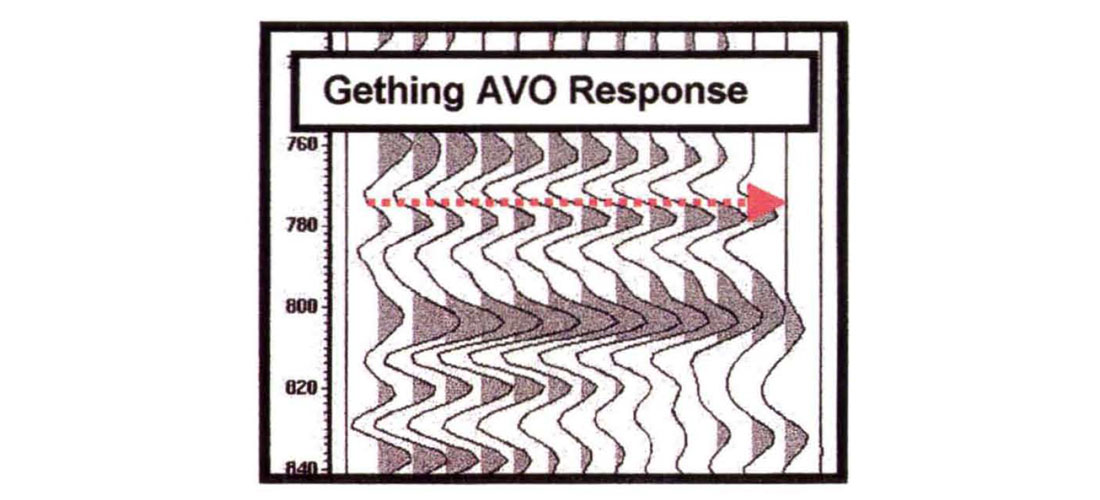
AVO modeling of the Gething gas sands demonstrates that the amplitude variance with offset response can be used to reduce risk in development and exploration drilling. AVO forward modeling was carried out on several Gething gas producers in the study area. The gas sands exhibit a Class 2 AVO response as they are near-zero impedance contrast sands that develop an increase in negative impedance with offset. The comparison of the model to real-data, Ostrander-binned gathers show an excellent correlation.
Models for Gething coal indicate a decrease in amplitude with offset, also confirmed by the data.
The geophysical methods utilized provide unique seismic solutions for lithology, reservoir contents, and reservoir quality.
Evolution of both exploration and development projects within study area are discussed and many working examples of the channel mapping and of the gathers over gas-sand, non-reservoir, and coal are presented. Methods for practical and affordable use of AVO technology are also presented.


Join the Conversation
Interested in starting, or contributing to a conversation about an article or issue of the RECORDER? Join our CSEG LinkedIn Group.
Share This Article