Prior to 1984, shallow marine exploration in Canada was almost non-existent. Most recording systems were not readily adaptable for working on water. There were no marine cables. Airguns had been in Canada for some time, but were used primarily for infill coverage and testing. Some equipment had been brought in from the United States for specific jobs, generally north of the 60th parallel and in Alaska.
Lakes and rivers were shot, for the most part, using conventional dynamite methods on ice. There were concerns with shothole drilling, and the possibility of cross contaminating surface water and subsurface aquifers. Environmental restrictions have now prevented the use of shotholes in water bodies throughout North America. Airguns were originally developed to explore the oceans, and offshoots of this concept have been used to scare fish from pump intakes for hydraulic generators and fresh water intakes, silent pile drivers, avalanche control, etc. Airguns and waterguns are now required in fish-bearing lakes because the shock wave produced by the underwater blast does not kill fish.
Gunboats designed for working in the oceans are often over 200 feet in length with large high pressure compressors which can supply up to 80 airguns towed in an array. The targets are usually deep and require much more energy to produce seismic reflections than that required for western Canadian plays. Our challenge is to produce high frequency data usually at less than 2 seconds. Shallow marine equipment is often used to fill in the gap between land and the point at which the ocean going boats must turn. This can be accomplished with the use of a mini streamer (towed hydrophone cable) for 2 dimensional acquisition or conventional shallow 3D marine seismic methods.
Shallow marine seismic, as we know it today, started in Canada circa 1985. The Digiseis and DFS V recording systems were initially used to acquire two dimensional seismic data. Digiseis was a bona fide marine recording system, and the DFS V was a land system adapted to the marine environment. Both airguns and waterguns were used to provide energy. Many lakes were shot with different crews often working the same lakes at the same time. Data quality was marginal and interest waned.
Shallow marine acquisition lay dormant until 1988.
In 1988 Phillips Petroleum expressed an interest in acquiring data on Peerless Lake. A gunboat was assembled and outfitted with two airguns. Flat bottomed fishing boats were brought in from the west coast and modified to handle the radio telemetry recording equipment and Bay cables (hydrophones molded to the cable). The recording equipment was supplied by Phillips Petroleum, USA.
Several lakes were shot after Peerless Lake with different clients using the same equipment. The recording system was early generation and somewhat inefficient. The floatation devices had a tendency to leak, tip over, and were time consuming to open and close for maintenance. The cable weights were inadequate and the Seismic equipment had a tendency to drift in the wind. These equipment problems contributed to escalating costs. Even when conditions were favorable. data retrieval was extremely slow by today's standards. Interest in this type of acquisition equipment declined over the next few years until PanCanadian petroleum became involved.

In 1991, PanCanadian decided to explore under Lake Newell, in southern Alberta. They constructed hydrophone cables and floatation equipment for the next generation of the Opseis recording system, necessary to record a 3D seismic program on the lake. This program may have been the first truly three dimensional, shallow marine seismic program shot in Canada. The information gathered at Lake Newell was very good quality (Figure 1) and the resultant drilling program was quite successful. As a result, in 1992, a second stage of the Lake Newell program was completed. Interest in gathering shallow marine data grew and many lakes in Alberta, Saskatchewan and B.C. were subsequently shot successfully.

Shallow marine techniques and equipment are constantly being upgraded to meet the increasing demands being placed on the Seismic industry. Flat bottom boats (Figure 2) have been designed and built to deploy recording system electronics and cables. Fresh water gunboats (Figure 3) are capable of carrying high pressure compressor modules and various arrays of airguns. Source parameters can be determined on site.

Experimenting with and testing combinations of chamber volumes will optimize energy and frequency response for the location. Approximately five feet of head pressure is required to captivate the air released from the gun. Less than five feet of head pressure can result in a blowout which reduces penetrating energy and loss of higher frequencies. Self drilling guns and augers (Figure 4) have been developed to provide this head pressure in transition zones and swamps with less than 5 feet of water.

The presence of nesting fowl and spawning fish may cause restrictions when applying for approvals or permits for the acquisition of seismic data on lakes. Landowner concerns, and Public Lands may place restrictions on the time of year that crews can operate on recreational lakes (usually between the long weekend in May and the long weekend in September). Relaxations may be authorized, which will allow weekday operations on recreational lakes. At times, gaps are necessary between the high water mark of a lake and the closest shothole or V.P. on land.
State of the art recording systems are now available to the industry through various seismic contractors. Equipment is now available to shoot from dry land and on into swamps, rivers, lakes and ocean transition zones and processing techniques have been developed to match the phase differences which occur. An example of this is shown in Figure 5 which shows the transition from geophones to hydrophones.

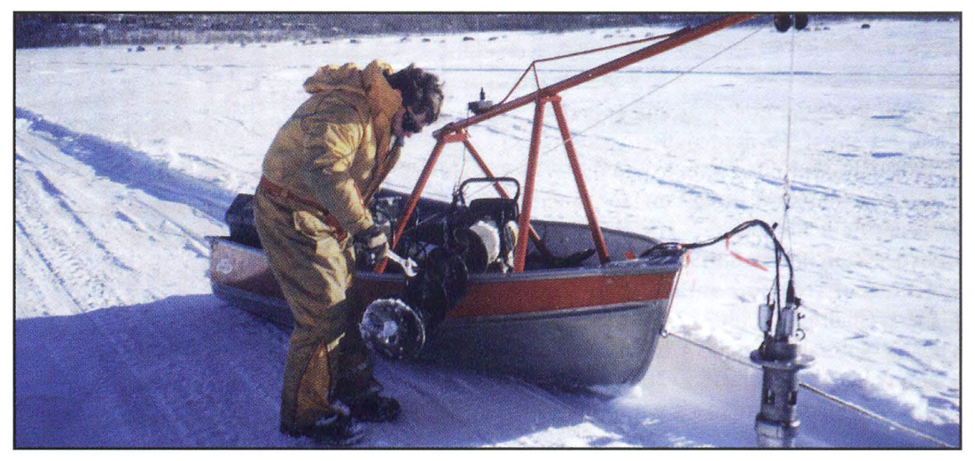
Equipment is also available to acquire data on lakes and rivers in the winter through the ice (Figure 6). This method usually works well for infilling gaps in coverage for 2D, and portions of 3D programs. Open water is more desirable because we do not have to deal with reflections from the bottom surface of the ice, ice cracking, and air gaps which may form between the lower ice surface and the water. Safety is always a great concern when working on ice. Extreme caution is required due to the danger of falling through the ice. Figure 7 shows a crew acquiring data on ice with a light weight nitrogen charged airgun. A small boat is used to avoid loss of equipment and personnel due to breaking through the ice. Note the operator wearing the floater suit.

The shallow marine industry is not standing idle. Marine technology coincides with the advancements made in conventional land systems. Seismic lines need not be terminated when bodies of water are encountered.


Join the Conversation
Interested in starting, or contributing to a conversation about an article or issue of the RECORDER? Join our CSEG LinkedIn Group.
Share This Article