Introduction
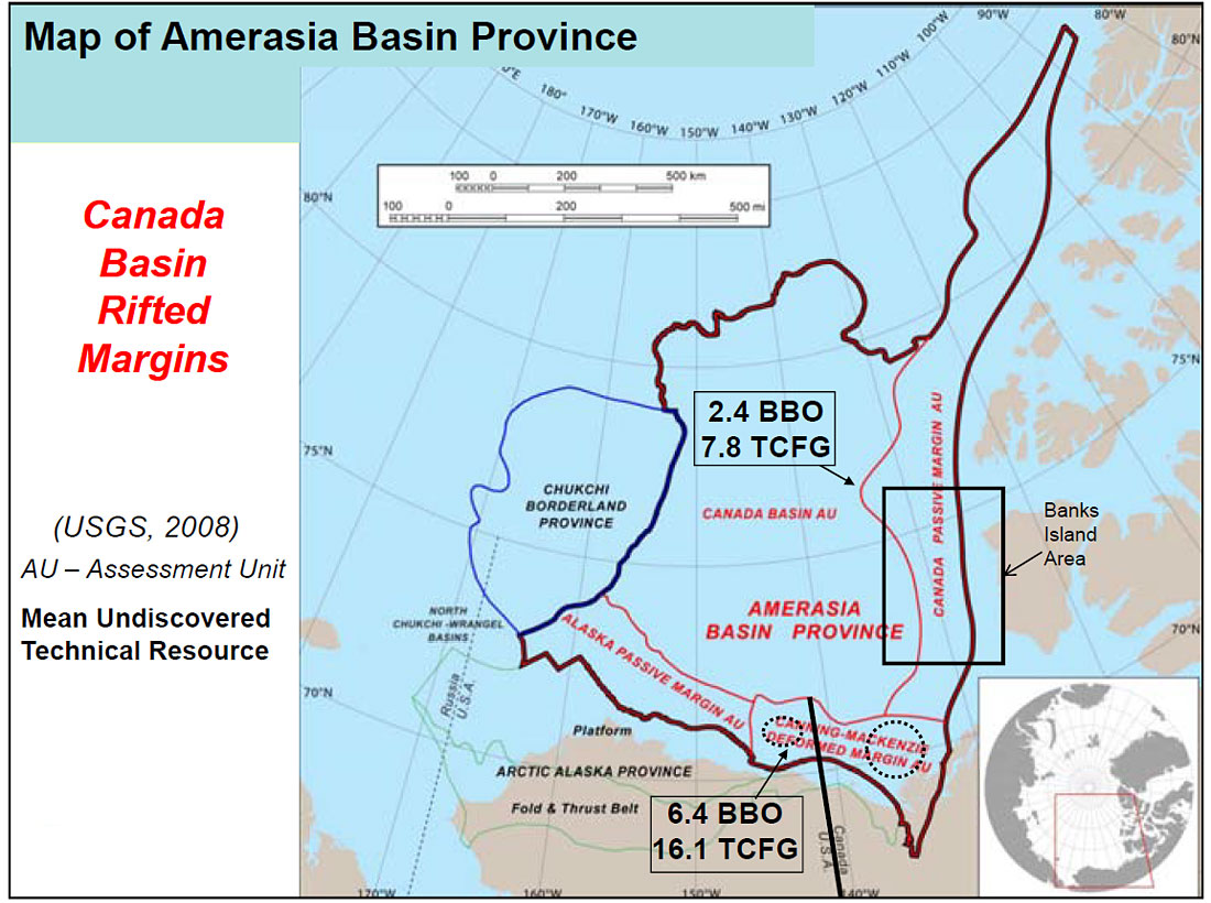
Because of its thick sediment wedge and large structures, the exploration focus in Arctic Canada has been on Beaufort- Mackenzie Delta for more than thirty years. This effort has resulted in 48 oil and gas discoveries with a combined volume in excess of 1 billion barrels equivalent (Chen and others, 2007). Although commercial production is yet to begin in this area, significant leasing and seismic activity in the area continue. However, the adjacent Canada Passive Margin has received comparatively scant attention, primarily because seismic and drilling operations in the area are very time consuming and expensive, and the Mackenzie Delta continues to offer highly attractive opportunities (Dinkelman and others, 2008a). We believe that the Banks Island offshore, part of Canada Passive Margin closest to the Mackenzie Delta, has all the components of a potential major petroleum province and therefore deserves serious attention from the oil and gas industry (Figure 1).
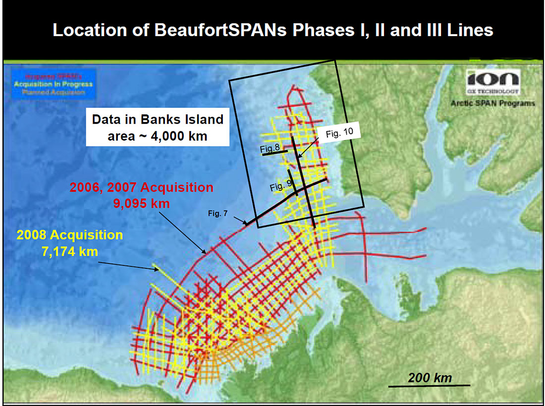
To expand the knowledge of the basin architecture, ION Geophysical (GX Technology) has acquired more than 4,000 km of 2-D long-offset reconnaissance seismic data in the area in three seasons since 2006 as a part of the BeaufortSPAN™ East program consisting of more than 16,000 km of seismic lines in the Canada Basin (Helwig and others, 2009 a, b). The seismic lines are located parallel and perpendicular to the Banks Island margin and in the Amundsen Gulf to the south. Cognizant of deep-water potential, the lines extend as far offshore as possible and as permitted by ice conditions and environmental considerations. The SPAN™ programs have been designed to image down to the base of the crust with a 9-km long cable, 18-second recording, and final depth processing (Prestack Depth Migration) to 40 km. The seismic data are interpreted together with simultaneously collected gravity and magnetic data to regionally map the ocean-continent boundary and the top of MOHO discontinuity, and tied to existing well data wherever possible to identify the major stratigraphic sequences. Thus the study is designed to image the entire crust and basin architecture, and the seismic resolution within exploration depths (down to 8 km or so) is excellent, revealing details of structural and stratigraphic features (Dinkelman and others, 2008a).
In this paper we summarize the observations in the Banks Island offshore in the context of a potential petroleum system, i.e. we describe the observations that have led us to suggest the existence of traps, reservoirs, source rocks, and timely maturation and migration in the area. The observations are based on the new seismic data, regional geology, and published data. This paper is primarily based on the interpretation of 2007 data; the 2008 data is currently in final processing (Kumar and others, 2009a).
Regional Geology
The area outlined in the black rectangle in Figure 2 covers approximately 70,000 square kilometers, approximately the same size as the Mackenzie Delta. The BeaufortSPAN lines extend seaward from 20-m water depth and are oriented in strike (coast parallel), and dip (perpendicular to the margin) directions. As shown in Figure 2, the 2008 lines extend farther oceanward than the 2007 lines.
The geology of the Canadian Beaufort Sea continental margin is well known in the area of the Mackenzie Delta and shelf where more than 200 exploratory wells were drilled in the 1970s and 80s and numerous seismic surveys were conducted. The Geological Atlas of the Beaufort Mackenzie Area, published by the Geological Survey of Canada (Dixon, 1996), provides comprehensive data and interpretation for the subsurface stratigraphy, structure, geologic framework, and petroleum potential of the Beaufort-Mackenzie Basin. The opening of Canada Basin has been described as an anticlockwise rotational opening (“windshield wiper” motion) in which the Arctic Alaska and Chukotka Block must be rotated back to close the Canada Basin and rejoin Northern Canada and Canadian Arctic Islands (Embry 1990, Grantz and others, 2007). Regional gravity data appear to support the rotational model. Under the rotational theory of the opening of the Canada Basin, the BeaufortSPAN data (Figure 2) literally covers the “pivotal point” in the platetectonic history of the area. At the same time it should be obvious that this data set extends over a minuscule part of the entire basin (Dinkelman and others, 2008a).
There is another set of literature that calls for more “orthogonal” opening of the Canada Basin and denies direct connection of Arctic Alaska-Chukotka Block against the Canadian Arctic Islands (Lane, 2002). Lane’s primary argument is that if the Canadian Arctic Islands and the Northern Alaska and Chukchi Shelf were conjugate margins, their pre-opening geology should be identical. In his analysis, he finds irreconcilable differences in the geology of the two margins. On the other hand, Embry (1990) and Sherwood (1992) have presented models that reconcile the geology and continuity of tectonic features across the conjugate margins. Although attempts to support or contradict one or the other hypothesis are beyond the scope of this paper, we basically adopt the rotational hypothesis as our working model. We also believe that through the observations made from our SPAN data in the US Chukchi shelf, further support for the rotational model can be provided (Kumar and others, 2009b). One of the goals of the interpretation of the ArcticSPAN data sets is to compare the seismic features mapped in the “preopening” sequences of the US Chukchi Shelf with comparable sequences in the Canadian Passive Margin. This work is in progress (Dinkelman and others, 2008b). The multistage opening history proposed by Grantz and others (2007) attempts to overcome some of the space and timing problems that have persisted with earlier versions of the rotational model.
The pre-rift geology of the Banks Island margin comprises the Paleozoic North American Craton flank extending from the north and continuing south to the Mackenzie Delta. To the west and southwest, the emergent Brooks Range and contiguous British and Barn Mountain fold and thrust belt extends offshore to form the Canning-Mackenzie (Beaufort) fold belt (Figure 1, Helwig and others, 2009b). In the Banks Island area, coastal onlap of Cretaceous and younger sediments marks the landward edge of a Mesozoic-Tertiary sedimentary prism deposited at the continental margin of the Canada Basin.
Stratigraphy and Evolution of the Banks Island Margin
Because there are no offshore wells in the area, the stratigraphy of the area has been extrapolated from onshore drilling and extension of the offshore stratigraphy from the Mackenzie Delta area. The surface geology of the Banks Island consists of Paleozoic-age rocks with a relatively thin cover of Mesozoic-age rocks in the western part of the island. Figure 3 shows the Ordovician through Devonian-age formations recognized in these wells. The correlations and ages are taken from Harrison and Brent (2005).
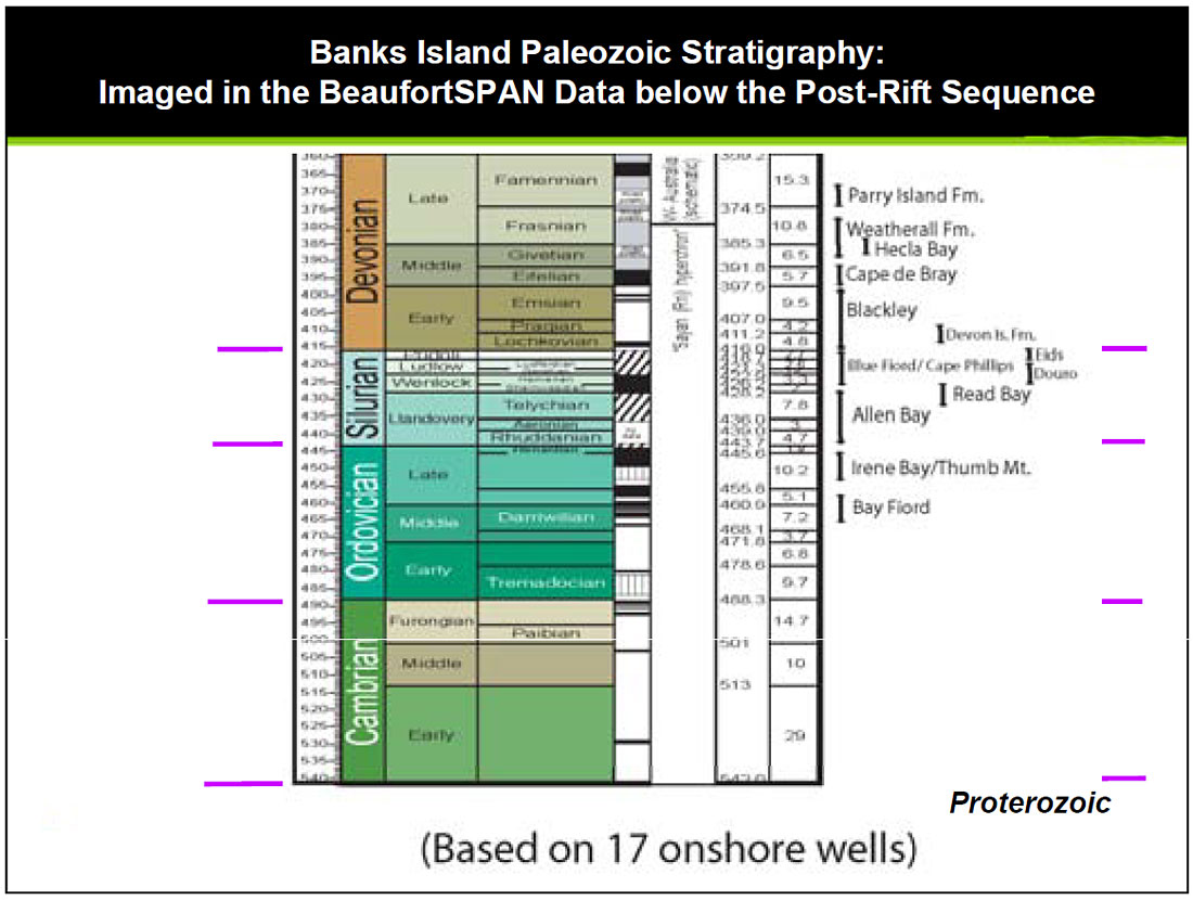
Figure 4 is a summary of the stratigraphy and tectonic history of the Canadian margin (modified from ConocoPhillips, 2004, Helwig and others, 2009b). Although the Mesozoic formations recognized in the onshore wells on Banks Island use a different set of names (Harrison and Brent, 2005) than the formation names used in Mackenzie Delta onshore and offshore (Dixon, 1996), we have followed the Mackenzie Delta stratigraphy for Banks Island offshore because the regional seismic lines of BeaufortSPAN survey show remarkable continuity, especially in the Late Cretaceous and younger seismic horizons. We recognize that there must be regional age and facies differences between the two areas but as described below, because their post-rift evolution is obviously related and the existing well control is so limited, it is reasonable to use the established Mackenzie Delta stratigraphy for the Banks Island margin.
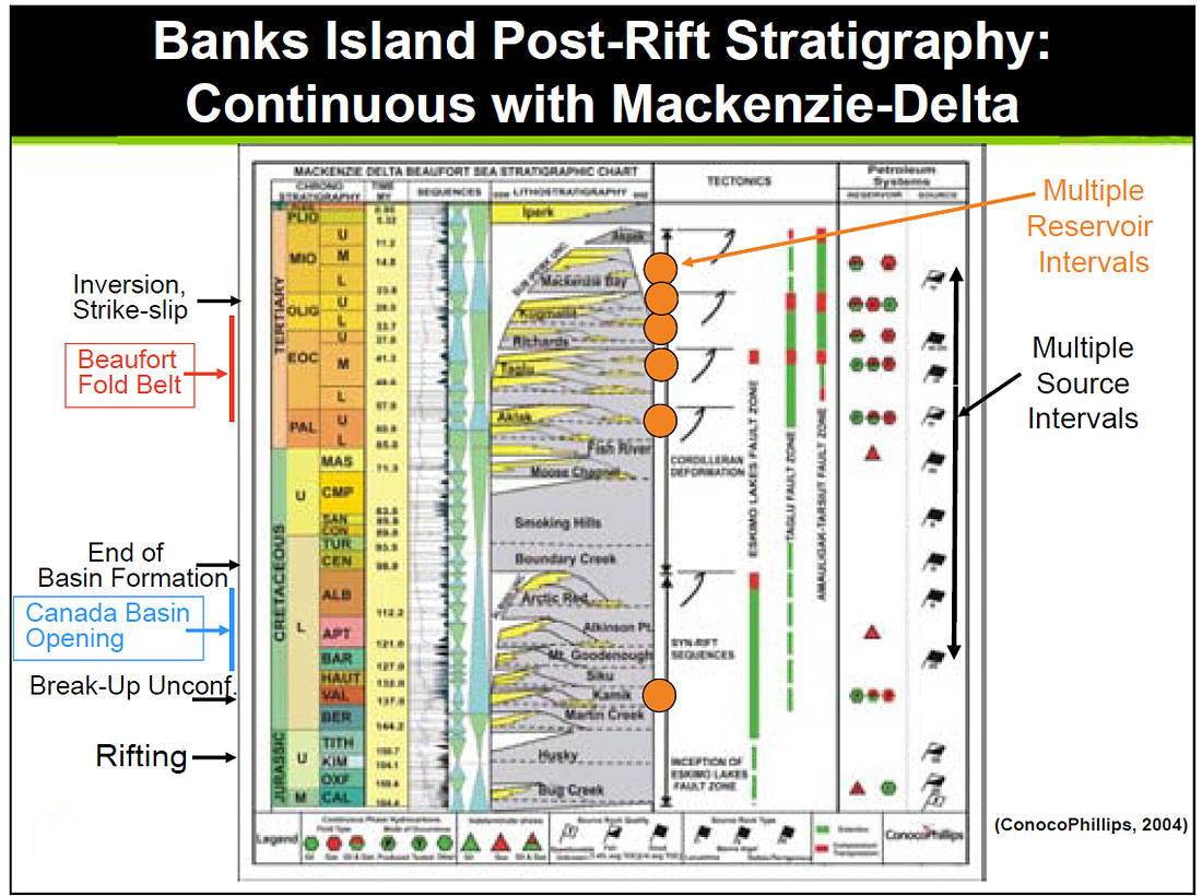
The following summary of Canada Basin evolution is based on work by Helwig and others (2009a, b). Sedimentation in the basin was initiated with influx at the time of the Canada-basin opening through rifting in the Late Jurassic (150 my) time. Some of these initial sediments were deposited on Late Devonian and older rocks, including the crystalline basement, underneath the present-day shelf. The rift-phase of the basin history culminated in Valanginian (140-136 Ma) time, and is mapped as the breakup unconformity. Sea-floor spreading in the Canada Basin was initiated soon thereafter; this episode terminated in mid- Cretaceous time (Grantz and others, 2007). After the sea-floor spreading in the Canada Basin was completed; a phase of Upper-Cretaceous flooding and shaly deposition onto the early Cretaceous topography had taken place. We have identified several (up to 3) events as Santonian, 83.5 Ma. Because of lack of control, we cannot assign individual ages to these reflectors. Most of this deposition took place in the Mackenzie Delta area but we have been able to extend the seismic events to the Banks Island region as well.
A third phase in the basin is the Paleogene-Eocene progradation of mixed clastic sediments derived from the Mackenzie River and elsewhere, and the contemporaneous initial folding in the EW trending Beaufort Foldbelt. The established stratigraphy is mapped in distinct seismic events – Mid Paleocene (61 my), Early Eocene (52 my), and Mid Eocene (41 my) as key regional unconformities or flooding surfaces. Although there is no well control available in the area, we have carried these regional reflectors to the Banks Island area where, the strata are not folded by this phase. We also suggest that although the Mackenzie River supplied a majority of the sediment volume, local sources, especially in the Amundsen Gulf area, also supplied sediments during periods of relatively low stands of sea level.
The fourth phase in the basin is the Oligocene Kugmallit phase of deposition bounded by major unconformities. In the Mackenzie Delta region, growth folding passes eastward into wrench-related pull-apart extension in the ENE-WSW trending Amauligak Trough which is filled with up to 6 km of coarser clastic sediment including deep-water fans (Dixon, 1996). It is possible that this wrenching affected structures farther north all the way to the Banks Island margin. This work is still in progress awaiting the interpretation of the latest, Phase III, data. However, a “Kugmallit” equivalent low-stand phase is assumed to have contributed to the sedimentary prism at the Banks Island margin as well.
The Miocene through Plio-Pleistocene sediments, deposited in the fifth and sixth phases of the history of the basin, have essentially created the present-day shelf and slope topography. The youngest sedimentary horizon mapped in the data, at the base of the Plio-Pleistocene (Iperk) sequence, represents the Late Miocene (5.3 my) unconformity. Within the Plio- Pleistocene and recent sediments, the youngest outer-shelf hiatus is overlain by prograding deltaic deposits. Prograding shelf edges and various channel and slump features are evident in all profiles, and these pass basinward into slope and fan facies. Figure 4 summarizes various tectonic and evolutionary events on the left side of the figure as well as in the column marked “Tectonics”.
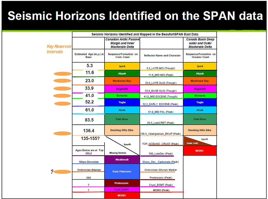
Figure 5 is a summary of various horizons mapped in the seismic data on the continental- as well as the oceanic part of the Canada Basin margin. This summary diagram is essentially the same as published in Dinkelman and others (2008a) and it incorporates the interpretation results from Phase I and II data. As mentioned earlier, Phase III data is still in final-processing stage.
Potential Petroleum System in the Banks Island Margin
Figure 6 is a chart displaying the various components of the Petroleum System operating in the Beaufort- Mackenzie area. It displays the components required to form a petroleum system which would lead to accumulations, plotted against geological time scale, following the method and terminology proposed by Magoon and Dow (1994). Although no geochemical or basin modeling has been carried out for this study, the data needed to construct this chart is available in Dixon (1996), Chen and others (2007) and Houseknecht and Bird (2008). Although this chart omits a possible Paleozoic Petroleum system, our data image a sequence of markers, interpreted to be of Paleozoic age, under the Banks Island shelf (Figure 5). These may also have potential source and reservoir intervals (Harrison and Brent, 2005). Thus, although a low probability, a pre- Mesozoic petroleum system should not be discounted.
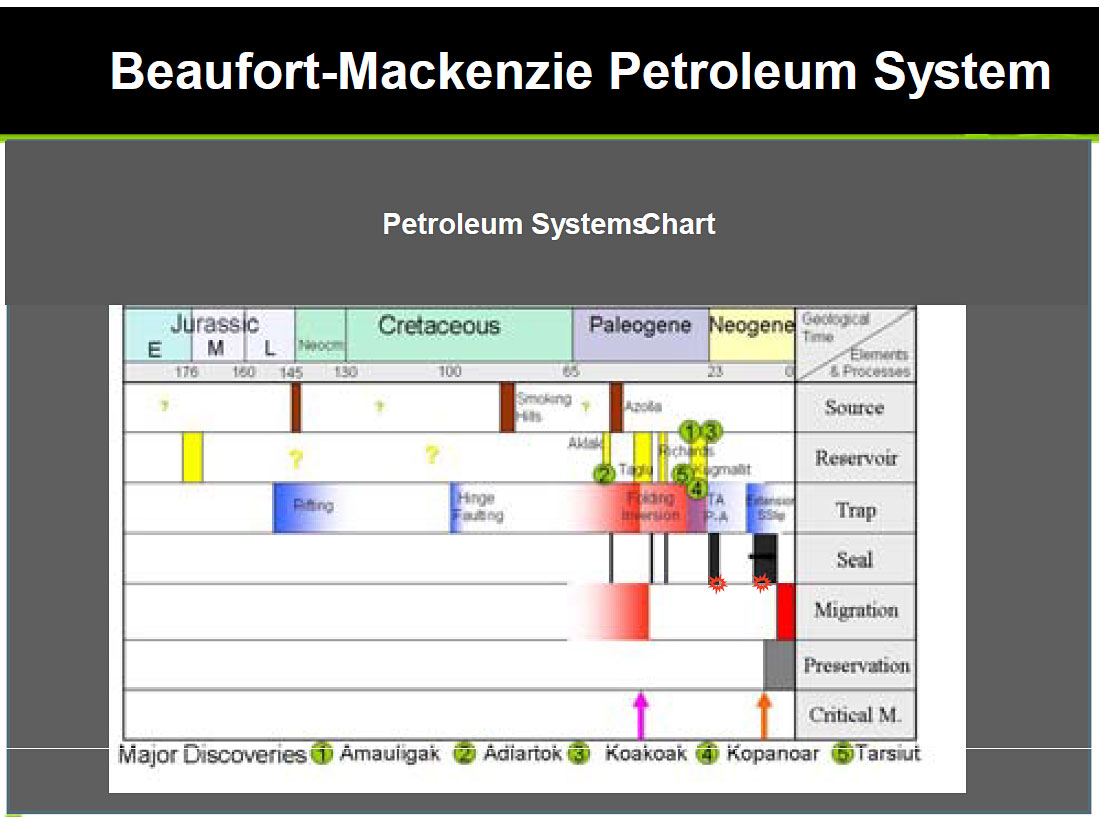
The following discussion of the petroleum system explains that with the exception of large-scale folding as seen in the Mackenzie Delta, petroleumsystem components conducive to hydrocarbon accumulations reliably exist in the area.
Source: The chart in Figure 6 indicates the presence of possible source rocks in Upper Jurassic, Upper Cretaceous and Paleogene times. The column marked “Petroleum Systems” in Figure 2 suggests the presence of potential source rocks in multiple levels throughout Cretaceous and Tertiary periods. An Arctic-wide “Azolla” source rock in the Paleogene time has been suggested by Houseknecht and Bird (2008). At this time although no well data is available to document the presence of source rocks in the Banks Island margin, we believe that the continuity of seismic markers from the Mackenzie Delta area suggest that suitable environments of deposition formed source rocks during multiple periods in an area much more extensive than just the Mackenzie Delta.
Reservoir: Figures 4 and 6 both indicate the presence of multiple pulses of sediment input that deposited coarse-clastic material within an overall sediment volume of shale-rich sediment wedge during Cretaceous and Tertiary periods. In the column labeled “lithostratigraphy” in Figure 4, the yellow areas with formation names mark the sandy pulses that form reservoir intervals among the various Mackenzie Delta accumulations. The controls on sediment input were primarily tectonic events onshore and eustatic changes in the sea level offshore. Although the primary conduit of sediments was the Mackenzie River and the primary repository of sediments was the delta area, these sediments were delivered through more than one conduit and were distributed in a widespread area. As in the case of source rocks, the continuity of seismic markers suggests good probability of sand-rich intervals along the Banks Island among the various intervals that form known reservoirs in the Mackenzie Delta. Although the nearest offshore well control is more than 250 kilometers away, as part of our ongoing studies we expect to pursue sequencestratigraphic investigation to map specific potential sand-rich intervals in the Banks Island area.
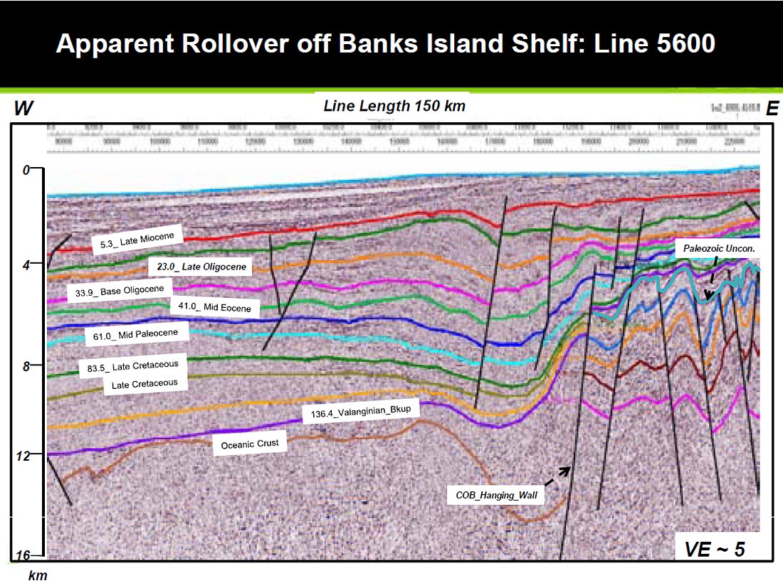
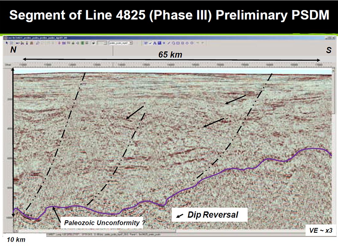
Trap: Although the Banks Island margin does not have the intensely folded structures seen in the Mackenzie Delta area, the seismic examples shown here provide ample possibilities for structural and stratigraphic trapping. Part of line 5600 shown in Figure 7 (location on Figure 1), crosses the Banks Island margin in a dip direction. A major rollover feature, showing a landward dip of all the Mesozoic and Tertiary horizons, is developed in the hanging wall of a west-dipping normal fault that appears planar and not listric. Whether this major structure is basement related or detached or related to wrenching is not yet clear. The structural relief, at the green horizon between the 5.6 and 23.0 my markers, is almost 800 meters over a breadth of almost 30 km. The Continent-Ocean Boundary is located almost 25-30 km landward of this rollover feature and is interpreted as a deep crustal fault. Additional Late Cretaceous and Tertiary faulting appears to be gravitational. The 2008 data give us additional control in the area and we expect to resolve the tectonic evolution of this folding in a regional context.
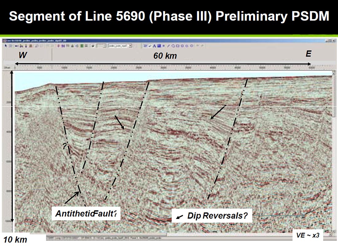
Figures 8 and 9 also show examples of structures that could form potential structural traps. These data are not yet interpreted and integrated with the rest of data but the presence of structures is undeniable. At this time we do not have a tectonic model to explain these features. Some are obviously gravitational. Deepseated faulting, as seen in Figure 7 might be related to late Tertiary strike-slip movements along major faults farther south (Helwig and others, 2009 b), but whether these movements created structures along the Banks Island margin is not known.
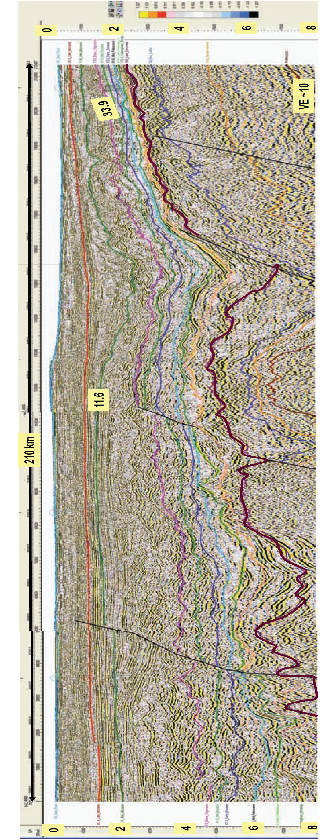
Seismic line shown in Figure 10 is a north-south traverse along the Banks Island slope just beyond the shelf edge (location shown in Figure 2). In the late Tertiary sequences, at the high vertical exaggeration (~10) of this display we see a highly irregular pattern. Erosion, “cut and fill” and slumping and “soft-sediment distortion” is obvious in the seismic section. These patterns are typical of "slope" facies and given more seismic control, would allow location of base-of-slope fan lobes that might contain potential reservoir facies and form stratigraphic traps. Amundsen Gulf, located at the right end of the line, appears to have acted as a sediment conduit at least since the early Tertiary time. Additional control obtained during the Phase III acquisition is expected to permit a better definition of these facies than is possible from a single line. However, examples shown in Figures 7 through 10 indicate that there are many possibilities of structural and stratigraphic trapping in the Banks Island margin.
Seal, Migration, Preservation and Critical Moment: Although lack of well data makes the evaluation of burial history in the Banks Island area ambiguous, we believe that there is sufficient information to suggest a favorable set of circumstances to generate, migrate and seal hydrocarbons in the area. Figure 11 is an isopach map of total post-rift sediment overlying the 136.4_Valanginian seismic marker. In the Banks Island area, this map displays a maximum sediment thickness of almost 10 km, in contrast to the sediment thickness of about 15 km in the Mackenzie Delta. Thus, although the delta is one of the thickest sedimentary accumulations in any basin, the Banks Island margin should also provide sufficient burial depth for organic source material deposited and preserved in the area. Because almost the entire sedimentary prism is shale rich, these shales would provide the seal for any hydrocarbons accumulated among the intervening sands.
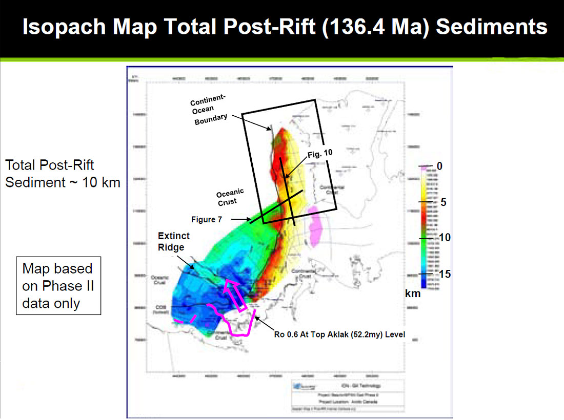
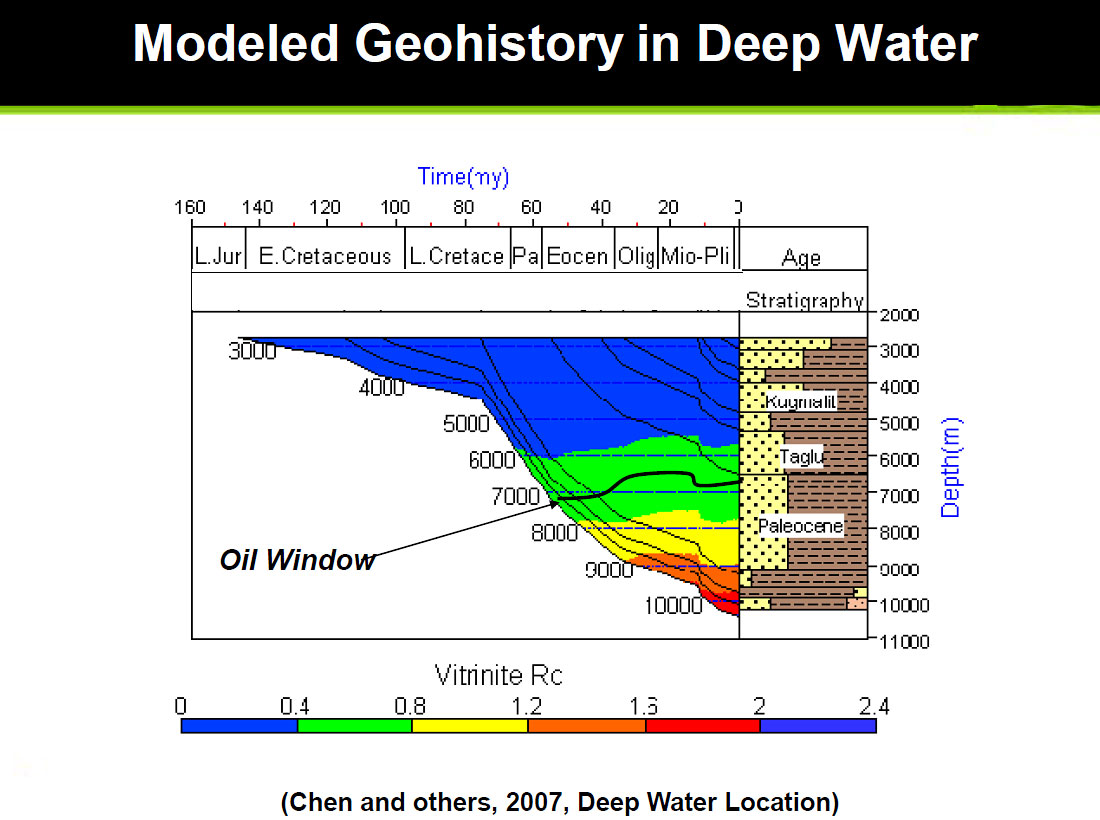
Figure 11 also shows in pink, a boundary seaward of which the Ro (Vitrinite Reflectance) is expected to be greater than 0.6 (Chen and others, 2007) at the Early Eocene (Aklak horizon) level. Although not shown in this paper, our mapping of Early Eocene horizon (52.2 my) in the Banks Island area indicates this horizon to be located between 3,000 and 6,000 m. Figure 12 shows a geohistory model for a hypothetical well located in deep water (Chen and others, 2007). This chart shows that the “oil window” would be present within 6,000 to 8,000 m range. At this time no other geohistory data are available in our study area and we assume that the model shown in Figure 12 would be generally applicable. Source rocks become “over mature” only in the >9,000 m range. Thus, given favorable source rock and a burial depth of +/- 8,000m, we should expect oil and/or gas to be generated in the area. With favorable pathways and traps, hydrocarbon accumulations should be expected.
Summary
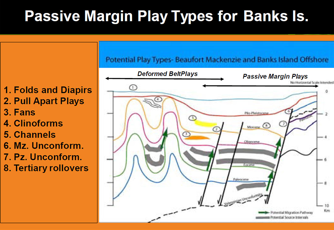
We have attempted to demonstrate that a viable and significant petroleum system, perhaps as significant as the one in the Mackenzie Delta, may be present along the Banks Island margin. As shown in Figure 6, all the appropriate components appear to be present in the area. New seismic data from Phase III will help in refining the expected geometry and tectonic and stratigraphic evolution of various possible traps in the area. Figure 13 is a schematic depiction of various play types (3 through 8) which are most likely to occur in the area. Crustal-level faults, as shown in Figure 7 might serve as migration pathways from the “kitchen areas” located as deep as 8 km. It is hoped that the favorable indications for hydrocarbon accumulations suggested in this paper would encourage the industry to carry out additional work and eventually to drill in the area, as lack of well control is the biggest obstacle to establishing the presence of petroleum habitat along the Banks Island margin.

Related Reading


Join the Conversation
Interested in starting, or contributing to a conversation about an article or issue of the RECORDER? Join our CSEG LinkedIn Group.
Share This Article