Overview
Walk over to your wall map and determine how much land in Alberta is under water, or dissected by rivers. If you knew your company could obtain superior seismic data in a “virgin” area at a reasonable cost, but, it would take planning, expertise, and real environmental stewardship, would you go there? We have - with focus, care, and attention to many details.
As the Western Canadian Sedimentary Basin matures, it is difficult to find an area not previously covered by seismic exploration. Seismic exploration into increasingly challenging locales has been happening for years, generally with escalated difficulties and accelerated costs. For some time, Sourcex, now Arcis Corporation, has been recording very high quality dynamite seismic data on rivers and lakes (including fish-bearing lakes) at quite reasonable costs. We’ve been asked to describe that process.
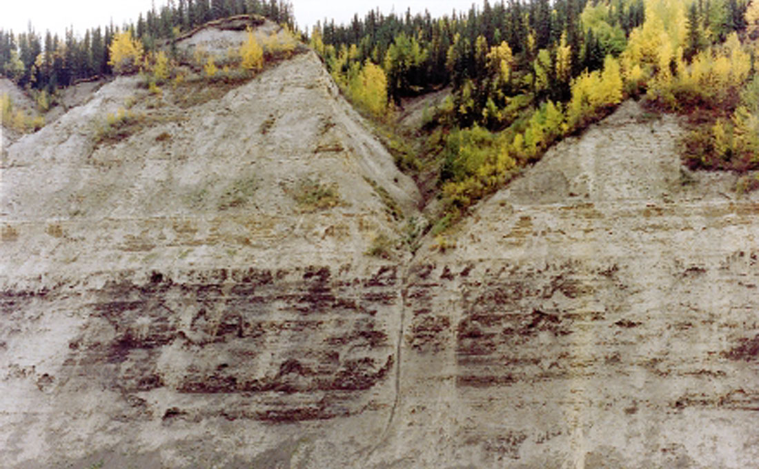
Interestingly enough, data quality is not a problem. For river shooting, huge thicknesses of overburden (see Figure 1, in the Peace River Valley) are taken out of the equation by using the river-bottom for shot & receiver placement. Recalling Figure 1, mentally image a shot-hole 200+ metres deep, with geophones placed below the same amount of overburden…you get the picture as to why the data quality can be so good. In the case of lake shooting, what better shot & geophone coupling medium than compacted, water-saturated silt & mud, “tamped” with the hydrostatic weight of meters of water?
Costs are surprisingly very reasonable, in part due to the absence of costs such as those associated with permitting, line-cutting and timber or crop damage. The actual seismic acquisition is slower, especially in the case of lake shooting, but again, not appreciably.
A warning: do not even consider approaching either of these environments unless you are prepared to maximize your attention to environmental stewardship and plan to leave absolutely minimal footprint! Great care needs to be taken to prevent damage to the physical environment and to the flora and fauna. Yes, we said flora…because in the case of lake shooting, disturbance of the habitat can be detrimental to the fish stocks (more on that later). Each time an application is made, considerable planning, then consultation with governmental regulators, communities and affected parties is undertaken. There is no such thing as a generic river or lake seismic application or approval. Each instance is site specific and requires a lengthy and appropriate process (as it should, since do we all not believe our waterways are critically important?)
River Shooting
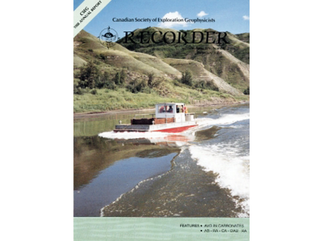
This environment, first tackled in the late 80’s by Sourcex, (Figure 2, front page of the Recorder, February, 1989, “Sourcex Shoots the Peace River”) using DFS V’s, a complete river-boat crew, and portable camps, has progressed to current times using ARAM 24 bit instruments, helicopters, and one or two “safety-boats”. Man-portable drills have been employed, and shallow, pattern shotpoints with very light charges are utilized.
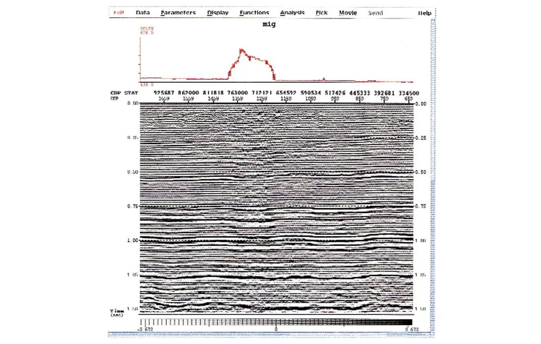
In all cases, from a manageable data quality standpoint, the single most important recording operation is still… the geophone plant by the Jughustler. As mentioned in the overview, Mother Nature does help considerably, by providing the “incision” into the earth of the (deep) valley geomorphology. Due to the avoidance of the source energy needing to penetrate thick overburden by drilling along the valley floor, only shallow holes & light charges are necessary for excellent seismic imaging, even to very deep targets. (Figure 3, from the Arcis Smokey River (Spec) Program, a 45 fold, 360 trace, 3600 meter far offset line, shows the change in data quality as the line leaves the valley floor, traverses a 120 meter high landmass, and returns to the valley floor. Even with extremely high fold and long offsets, the data below the “central hill” deteriorates down to 1.0 second. Notice also, how the data “heals” below 1 second, as the split spread is 3600 meters far offset and the hill is only 2100 meters across.) The number of examples of this phenomenon on other river valley lines is very large; in fact, it is always the case.
Advances in seismic recording technology have aided in the river shooting process. For example, in the early days, river cable crossings were literally “cable highwire” construction projects; now ARAM’s Microwave Netlink allows for simplified “electronic” crossings of major rivers. GPS surveying of river lines greatly reduces the complexity of the survey…both horizontal and vertical, in this environment.
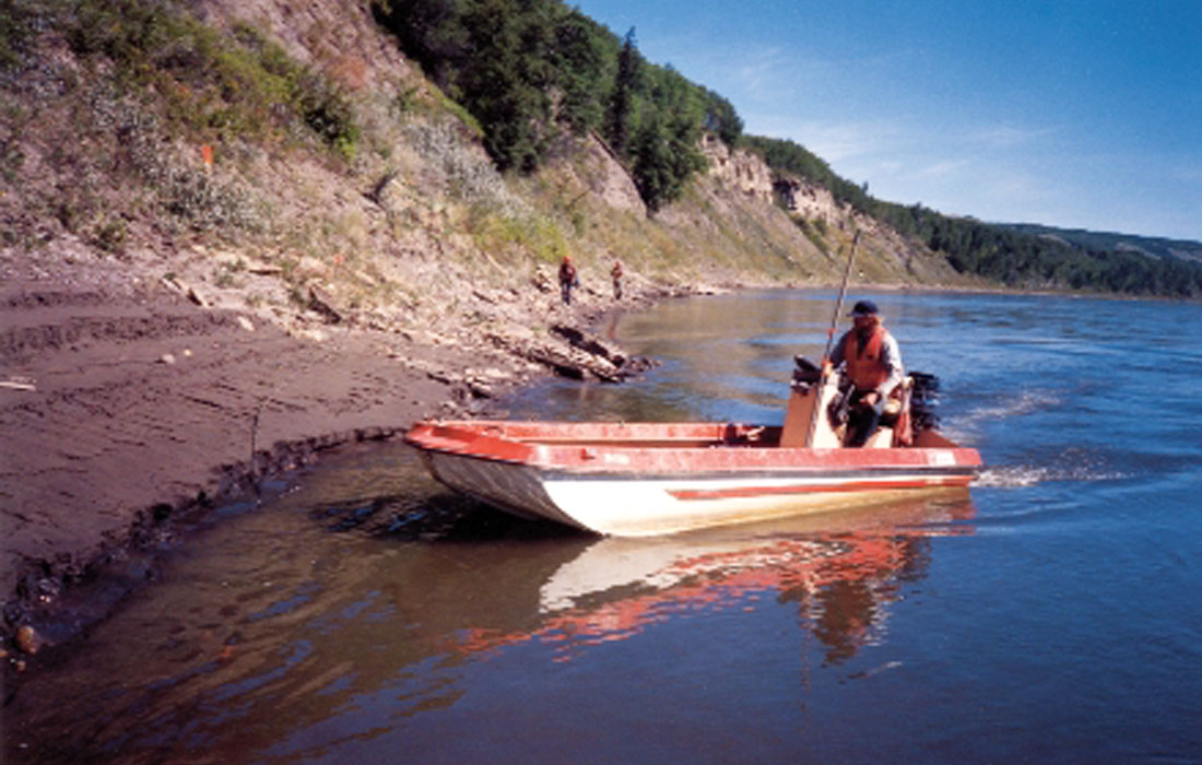
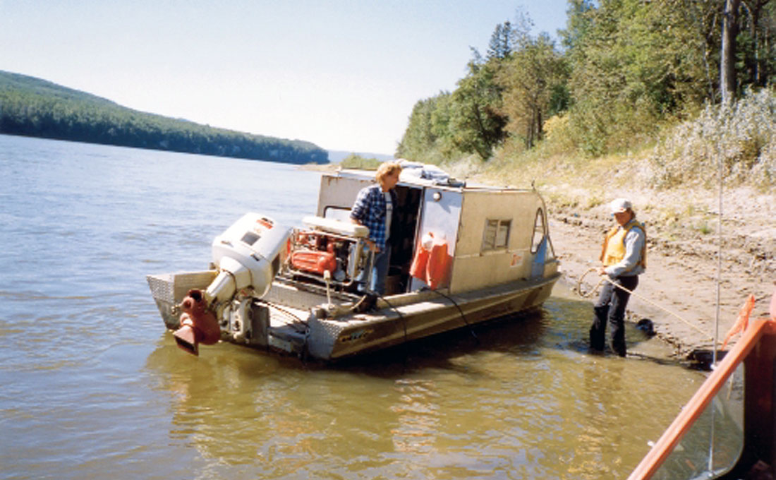
Initially, boats had to be used to move men and equipment along rivers (see Figure 4); that requirement considerably restricted the number of rivers big enough for that form of seismic recording. With the development of heli-assist recording, boats are used primarily for transporting drill crews & equipment, plus the requirement as “safety-boats” should a person fall into the water.
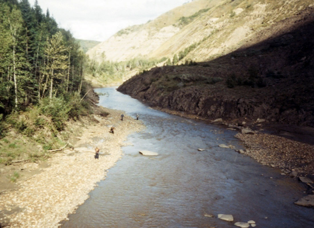
In some cases (see Figure 5, taken from a helicopter; note line crew planting geophones) the rivers or creeks are not used for transport; the valleys simply become the “incision” into the earth that provides for better data. The proprietary line location (thus confidential) shown in Figure 5 encountered extremely rocky shoreline and steep (often cliff-like) valley sides; still, the data quality was excellent. However, great care and planning was necessary for both locating shotpoints and planting geophones.
Advances in seismic processing, such as interactive crooked line binning, have provided better control over subsurface coverage. By interactively adjusting the CDP line beneath generally crooked, sometimes very crooked surface lines, it is possible to limit the effect of the crooked surface line on the subsurface image. Also, the ability to quality control and/or edit the CMP scatter based on the CDP-CMP distance and offset allows the processor to gather the subsurface image that will give the best stack response. Poor CDP binning can lead to problems in processing from static calculation, to NMO correction, to CDP stacking and of course migration.
Safety considerations
Although one might consider the Safety aspect of river shooting to be “obvious”, some things are more obvious than others. The safety of the personnel is paramount, as is their emergency transportation in the event of an accident. Because of the immediate nearness of (often) cold and flowing water, Personal Protective Equipment needs to be expanded to include PFD’s and potentially Survival Suits (depending on time of year). Boats may need to take over from helicopters for emergency transport; river valleys are prone to fog, restricting air travel. Communications systems must be completely reliable and consistently operational. Knowledge of factors causing rising water levels (rains, controlled outflows from dams, etc.) is critical; river levels can increase dramatically and relatively quickly. Danger to personnel and equipment from high water is a definite hazard. Regarding the equipment component… consider recording equipment that can be “in place” for days, and simply swept away by flooding water. Hundreds of thousands of dollars of equipment…gone like the stick you threw into the swift current (OK, like houses & cars washed away, not the stick…)
Shotpoint considerations
Because of the “incision” of the valley geomorphology, light charges are all that is necessary for excellent energy propagation to even very deep targets. Due to the need for portability, only “man-portable” drills have ever been used on lines (recorded by Arcis), thus shallow, pattern shotpoints are the norm. Heli-portable drills have never been necessary on any of our projects, and thus the costs of that type of drilling method have been avoided.
Government Approvals & Environmental Stewardship
Wildlife (fish) protection is critical, as is absence of disturbance of the water bottom (siltation potential) vis. spawning habitat. Initially, in the 1980’s, Sourcex & Alberta Fish & Wildlife did actual charge tests proximal to fish (in cages). When no damage to the fish was observed, approval for the operations was granted. When one recalls the extensive “dynamite” damage tests done in 1991 and after, by Dr. Ian Ross of ICI Explosives Canada (A Perspective on the Damage Potential of Seismic Detonations) it is not surprising that actual dynamite “blast” effects are quite minimal and thus potential effects to flora and fauna can be mitigated. More recently the Department of Fisheries & Oceans (DFO) has issued guidelines * and two equations that must be followed:
1. On-shore Setback from Fish Habitat for Confined Explosives (simplified):
“The calculations to determine the required setback distance to meet the 100 kPa (one atmosphere) guideline (maximum pressure allowed on a fish’s “swim bladder”) …can be simplified:
R = (W)1/2 (K),
where, R= setback distance,
W = charge weight, and
K is a constant equaling 2.13 in saturated soil, or 0.98 in unsaturated soil.**
2. Setback from Spawning Habitat (simplified):
Similarly… “the setback distance “R” required to meet peak particle velocity (Vr) guideline of 13 mm/sec (maximum velocity for not causing “silting”)…can be simplified”:
R = (W)1/2(15.09),
where R= setback distance,
W= charge weight, and 15.09 is a constant. **
*Wright, D.G., and G.E. Hopky. 1998 Guidelines for the use of explosives in or near Canadian fisheries waters. Can. Tech. Rep. Fish. Aquat.Sci. 2107: iv + 34p. **Ibid. Appendix III, p.23
In addition, access to rivers during particular fish species’ spawning times is restricted.
As local provincial government districts have final control over the actual approval of each seismic program, one must consider a reasonable and appropriate “process” of communication and sometimes education (regarding the specifics and river shooting history) with the governmental regulators. As described in the recent Doodletrain course “Best Bang for your Buck”, there is often a need to spend the time to explain circumstances and issues to our under-staffed provincial Renewable Resources (Forestry) personnel; river shooting is one of those.
Finally, one needs to consider the perceived impact of river shooting to the general public, and the specific location of potential programs. As “perception becomes reality” in the minds of concerned persons, be prepared for extensive consultations should your planned program be proximal to areas of “high visibility”.
Timing of Access Considerations
In order to “maximize” shoreline access (the amount of shore-line available for geophone planting & shothole locating), shooting must be done during times of low water levels in the spring or fall. Spawning restrictions also can restrict the limited window of time available. As a result, you need to have your “ducks lined up” well in advance of planned operational periods. Considering the length of time required for approval of any particular seismic application, one should plan a river shoot 6 -12 months ahead of the appropriate window.
A Few Other Tips
Many times it is critical to “tie” a river valley line into another grid of data. Data quality within 1-2 kilometers of most rivers is often quite poor. Three important factors:
- Shoot river crossing tie lines (ie lines running out of river valleys to tie into other seismic grids) with considerably higher fold & longer offsets (recall figure 2 data deterioration), and
- Locate tie lines up the bottoms of coulees (ravines, if you’re not from the prairies). Why? The ground/air ghost is focused away from the “spread,” there is less overburden in a coulee than otherwise, and (go figure) access is easier, as often game/cattle trails follow coulees out of the valley bottom (remember the critical geophone plant…).
- Line locating along a river is critical; you need an experienced Line Tracker to plan your line location. Wider river flats (for shotpoints) and absence of cliffs (if possible) are two simple items. Whereas most rivers meander, trust us, there is always a “good side” and a “bad side” and minimizing crossings does reduce costs and hazards.
Cost considerations
As mentioned previously, costs for river shooting are not excessive. To date, we’ve seen costs range from a minimum of $8,000/km to $20,000/km (all-up). The cost range is primarily dependent upon actual parameter selection (group interval & shotpoint interval), line length, and mobilization costs. (To gear up to shoot a short river line is obviously less cost-efficient than for a longer line.) Remember also, only very limited permitting (for access, staging) is required, as the river (Crown land) is the right-of-way. Line-cutting simply does not exist, as Mother Nature has already “cut” the line.
Conclusion
Ingenuity and “never say never” have often led to important advances in our science. The people at Sourcex, back in the 1980’s, took the first steps in an important advance towards exploring areas of historical extreme difficulty – rivers and lakes. They did it with logic, kept it simple and helped advance exploration in western Canada. Mixing seismic with water, when done with care, attention to the environment, and focus on the objectives, has led to a number of new pool discoveries.
Over the years we’ve heard of other attempts to shoot rivers in various ways, often with poor results, or “no approval granted”. It is not “brain surgery”, but it does require experience, knowledge, and careful attention to details - in the approval process, as well as in the seismic operations. Our waterways are important to everybody, so if you go there, be careful and tread lightly.
Shooting rivers has evolved into shooting lakes…stay tuned for the next episode.


Join the Conversation
Interested in starting, or contributing to a conversation about an article or issue of the RECORDER? Join our CSEG LinkedIn Group.
Share This Article