Summary
The US Chukchi Shelf is a highly prospective petroleum province with estimated mean technically recoverable resources of more than 29 billion barrels (4.6 billion cubic meters) of oil equivalent (MMS, 2006). Because of the remoteness of the area offshore of northwest Alaska and the high cost of operations, there has been only one round of leasing and drilling (5 wells) in an area equivalent to the state of Mississippi, and that was more than 15 years ago. With volatile oil prices and new technology, industry has shown a renewed interest in the area. In February 2008, at the first lease sale in seventeen years, seven groups bid a total of US$ 2.7 billion on 488 blocks. One company alone (Shell) bid US$2.1 billion out of this total (Upstream Review, 2008).
In late 2006, in response to industry interest and recognition of the area’s potential, GXT acquired approximately 3,200 km of 2-D, long-offset multiclient seismic data in the area. The program was designed to image down to the base of the crust with a 9-km long cable, 18-second recording, and final prestack depth migration (PSDM) processing to 40 km. The interpretation of the data has allowed us to regionally map the MOHO discontinuity and the top of the crystalline basement as well as to identify the major stratigraphic sequences which can be correlated to the highly petroliferous North Slope of Alaska. We have also attempted to interpret the rifting and compressional history of the area prior to the opening of the Canada Basin based on this data.
Highlights of interpretation of this data set:
- Although various stratigraphic sequences have been correlated from the North Slope of Alaska to the Chukchi Shelf, SPAN data has permitted establishment of a crustal- level framework (down to the MOHO discontinuity) for the area.
- SPAN data demonstrate that, although the five wells drilled so far have documented at least one active petroleum system (one discovery and hydrocarbon shows in the other four), the number of wells drilled to date is too small to test the potential of the basin. Our data show that not all of the wells were optimally located relative to structure nor did they test several play concepts.
- Parts of the Chukchi Shelf, such as the North Chukchi Basin, remain completely untested. This area contains up to 12 km (40,000 ft) of apparent Cretaceous- and Tertiaryage sediments which should be considered prospective in future rounds of drilling and testing.
- Although it has been known that part of the shelf is underlain by mildly deformed Devonian-age sediments which may be prospective for hydrocarbons, SPAN data have imaged the stratigraphy and structure in this part of the section in detail in the depth domain for the first time.
- Our mapping of the depth to MOHO and other horizons gives further support to the rotational model of the opening of the Canada Basin. This model has generated scientific debate but the concepts proposed by Grantz and Hart (2008) appear to be gaining general support in the scientific community. The results of our SPAN study are consistent with this model.
Introduction
The SPAN programs are laid out to provide a reasonable distribution of 2D seismic lines across recognized structural and stratigraphic provinces. They are thus designed to develop new plays and ideas, to provide regional geological insights into petroleum systems, and to more efficiently exploit established plays, develop new plays, and to trigger new ideas that may drive exploration and discoveries in the future. The ChukchiSPAN program was acquired in Oct. – Nov. 2006 with a shot interval of 50 meters, receiver interval of 25 meters and a sample rate of 2 milliseconds. The final processed data are 90 fold and have undergone Kirchoff PSDM to 40 km.
This program is part of an Arctic-wide effort to acquire, process and interpret high-quality data across margins that may contain commercial quantities of hydrocarbons. According to Bird and others (2008), mean undiscovered hydrocarbons north of the Arctic Circle could total 134 billion barrels of liquids (21 billion cubic meters) and 1,669 trillion cubic feet of gas (47 trillion cubic meters). So far, we have collected data in the Beaufort-Mackenzie area (Dinkelman, et al, 2008) and Chukchi Shelf (this paper). Several other surveys around the margins of Canada Basin are proposed (Figure 1).
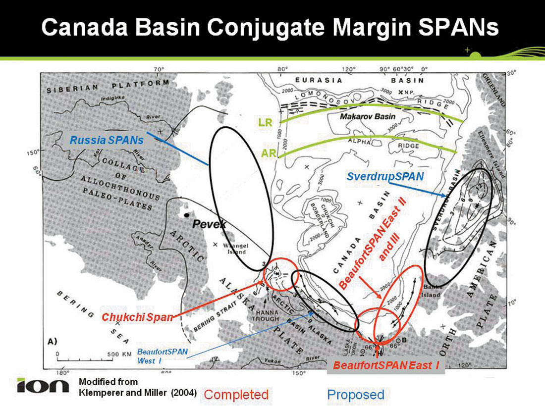
Figure 2 shows the program layout and the tectonic setting of the Arctic Alaska Province (Bird and Houseknecht, 2008). The seismic data are tied to the five existing wells in the area. Stratigraphic and tectonic interpretation of the data in a regional context forms the primary basis of conclusions in this paper. This interpretation was completed in October, 2007 prior to Sale 193 which was held in February, 2008 (Petroleum News, 2008).
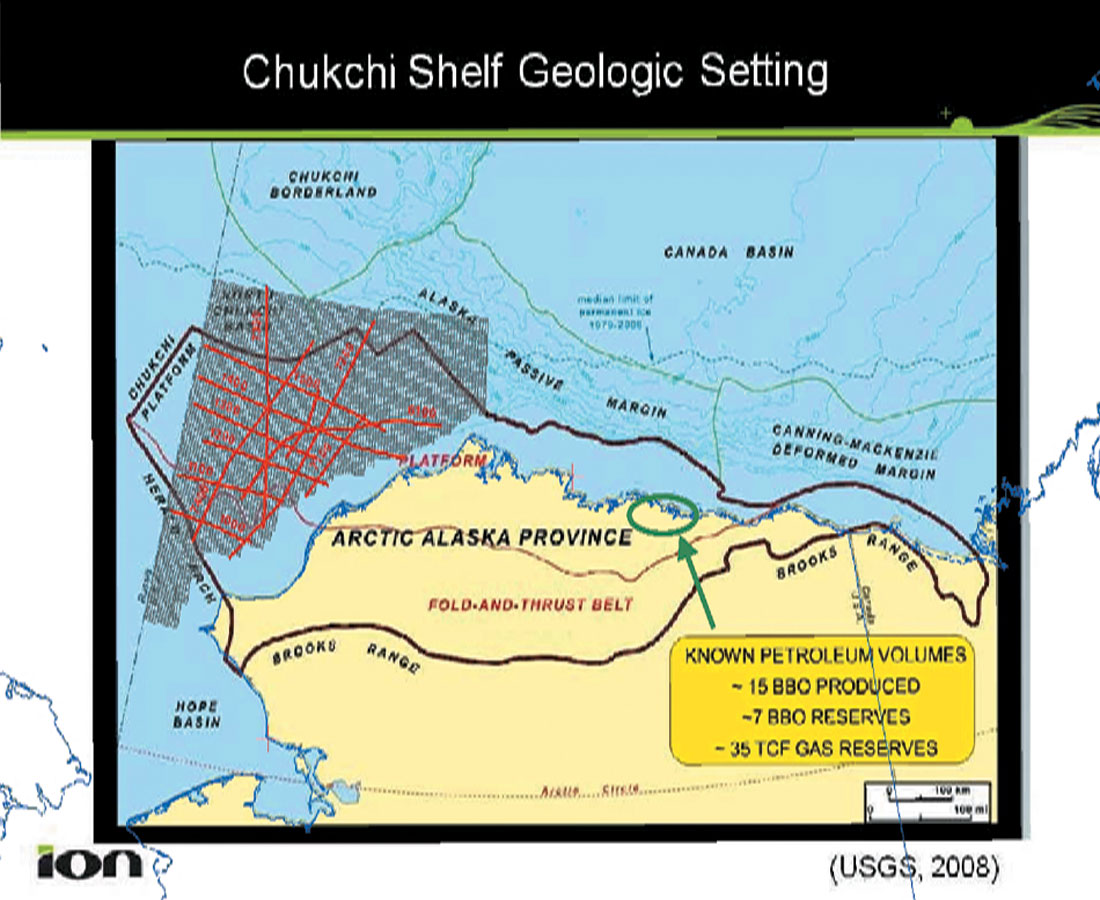
Plate-Tectonic Setting
Figure 3 shows a reconstruction of the Canada Basin margin prior to rifting and sea-floor spreading. The Alaska-Chukotka plate (numbers 2 and 3 in the figure) is juxtaposed against the Canadian margin. The relevant pole of rotation is presumed to be in the Mackenzie Delta area (number 1 in Figure 3). The Canada Basin rifting starts sometime after 150 my ago, and, by 136.4 (Valanginian time), the formation of oceanic-crust and counterclockwise rotation of the Alaska-Chukotka plate were initiated.
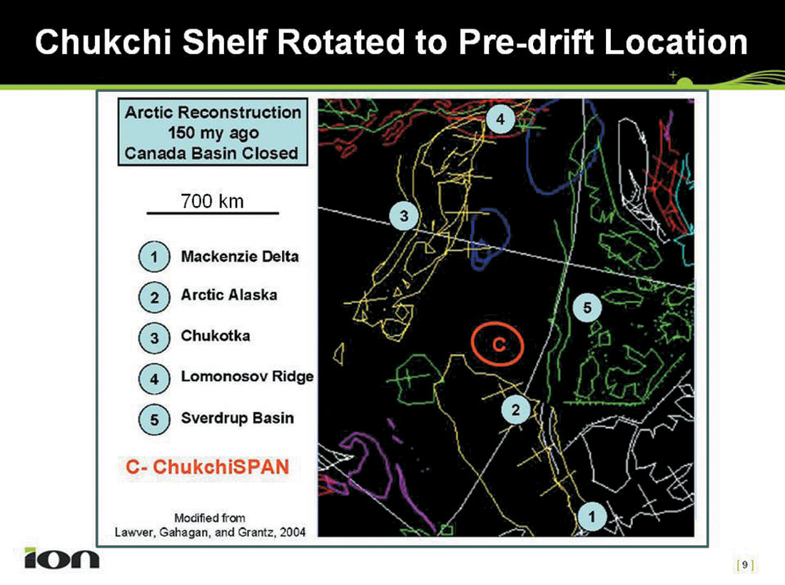
One of the criticisms of this reconstruction has been that it does not allow space for the Chukchi Borderland (central part of Figure 1) which is underlain by continental crust. Grantz and Hart (2008) have suggested a solution to that problem by keeping the Chukchi Borderland initially attached to the Alaska- Chukotka plate and subsequently separating it by clockwise rotation away from this plate. This scenario creates space for the Chukchi Borderland after the initial spreading had started. Although no oceanic crust need be created in its wake for this rotation and separation of the Chukchi Borderland away from the Alaska-Chukota border, some indication of crustal stretching caused by this separation would support the argument. As described later in this paper, we see indications of thinning of the continental crust in the northernmost part of our SPAN data (see locations of lines and their relationship to the location of the Chukchi Borderland in Figure 2).
Regional relationships in conjunction with our SPAN data, in particular the location of the Continent-Ocean Boundary (COB) in the Beaufort-Mackenzie area, the orientation of the spreading ridge, and its extension into the continent, all support the rotational model. Dinkelman and others (2008) have stated that the location of the spreading-ridge axis in the Canada Basin can be identified on regional residual gravity maps, and its track to the south towards the Canadian margin under the thick sediment wedge of the Beaufort-Mackenzie delta can be traced through our BeaufortSPAN East data. In the ChukchiSPAN data, stretching of continental crust between the Chukchi Borderland and the Chukchi Shelf also supports the rotational model. Thus our SPAN data appear to provide arguments supporting the rotational model in both the critical areas: the Beaufort- Mackenzie margin and the Chukchi Shelf.
Some authors (Embry, 1990; Sherwood, 1992) have also recognized the similarity and continuity of the Paleozoic geology of the conjugate margins based on well and seismic data available to them. Parts of the Paleozoic section in the ChukchiSPAN data set appear to be similar to the sections in the Canadian Arctic Islands, thus augmenting their correlation. With additional data acquired in 2008 along the Canadian Margin and other proposed surveys (Figure 1), we plan to continue to investigate the evolution of the Canada Basin.
Regional Geology
As shown in Figure 2, the U.S. Geological Survey includes the study area as part of their Arctic Alaska Province (Bird and Houseknecht, 2008). The area includes several structural elements. The Arctic Alaska Platform (Figure 2) extends offshore as depicted in Figure 4 (Domain III). The fold and thrust belt bordering the platform to the south extends offshore in the Chukchi Shelf (Domain I, Figure 4) as the Herald Arch (Figure 2). The thick sedimentary wedge in the foreland basin, the Colville Trough (Houseknecht and Bird, 2006), extends offshore into the Hanna Trough (Domain IV, Figure 4). The North Chukchi Basin (Domain V) is a Jurassic- and younger, rift-related feature, linked to the opening of the Canada Basin and the clockwise rotation of the Chukchi Borderland (Grantz and Hart, 2008). To the west, the Chukchi Platform appears to front the fold and thrust belt’s extension into the Russian Chukchi Shelf (Domain II, Figure 4). Because of the sparsity of data across the region and reliance on mostly regional gravity and magnetics data, the full extent of the North Chukchi Basin and the Chukchi Platform can only be speculated upon. Published information (Verzhbitsky et al, 2008) on the geology of the Russian Chukchi Shelf, however, is consistent with the interpretations shown here.
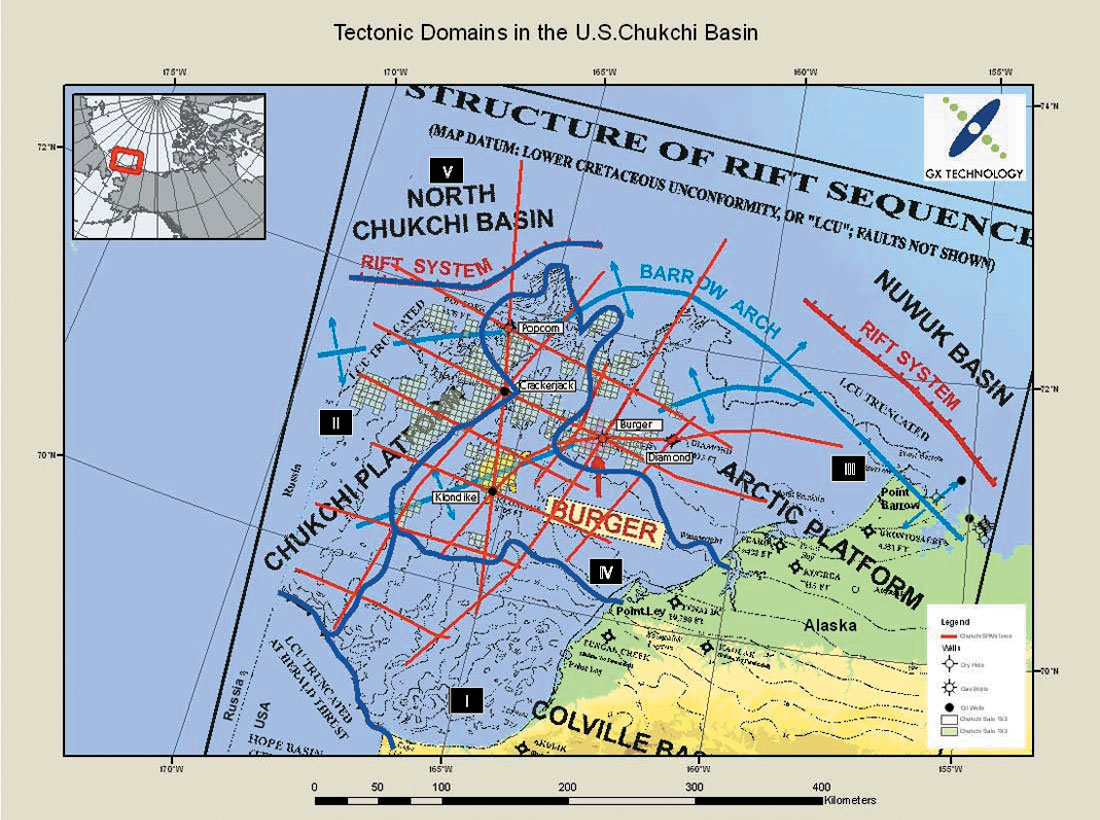
The stratigraphy of the Chukchi Shelf is based on five exploratory wells (Figure 4) that were drilled between 1989 and 1991. The key sedimentary sequences from the North Slope of Alaska have been identified in these wells (Figure 5, MMS, 2006). Figure 5 identifies the “pre-rift” Ellesmerian Sequence overlying the Franklinian Sequence, the Rift Sequence (also termed the Beaufortian Sequence, Houseknecht and Bird, 2006), and the “post-rift” Brookian Sequence. Figure 5 also displays the key reservoir and source intervals and significant sequence-bounding unconformities and analogue hydrocarbon accumulations associated with each of them. The fields on the North Slope of Alaska have already produced tremendous amounts of hydrocarbons (Figure 1).
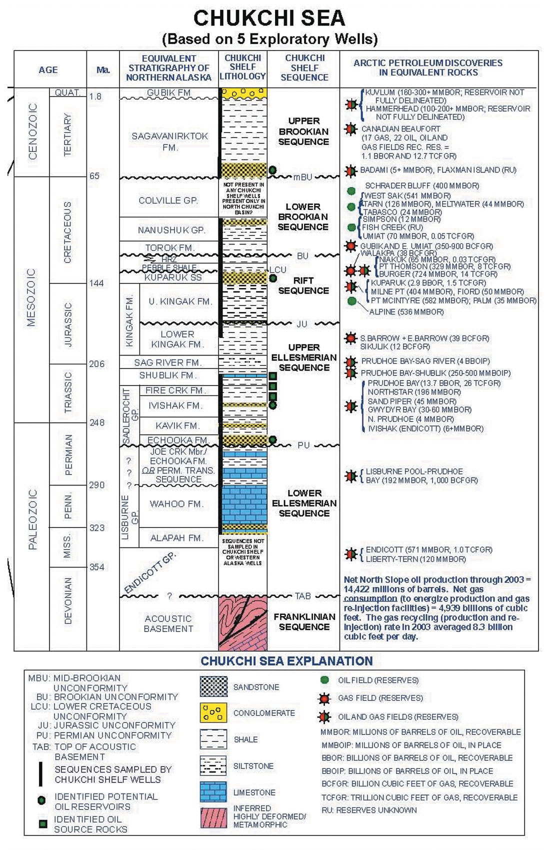
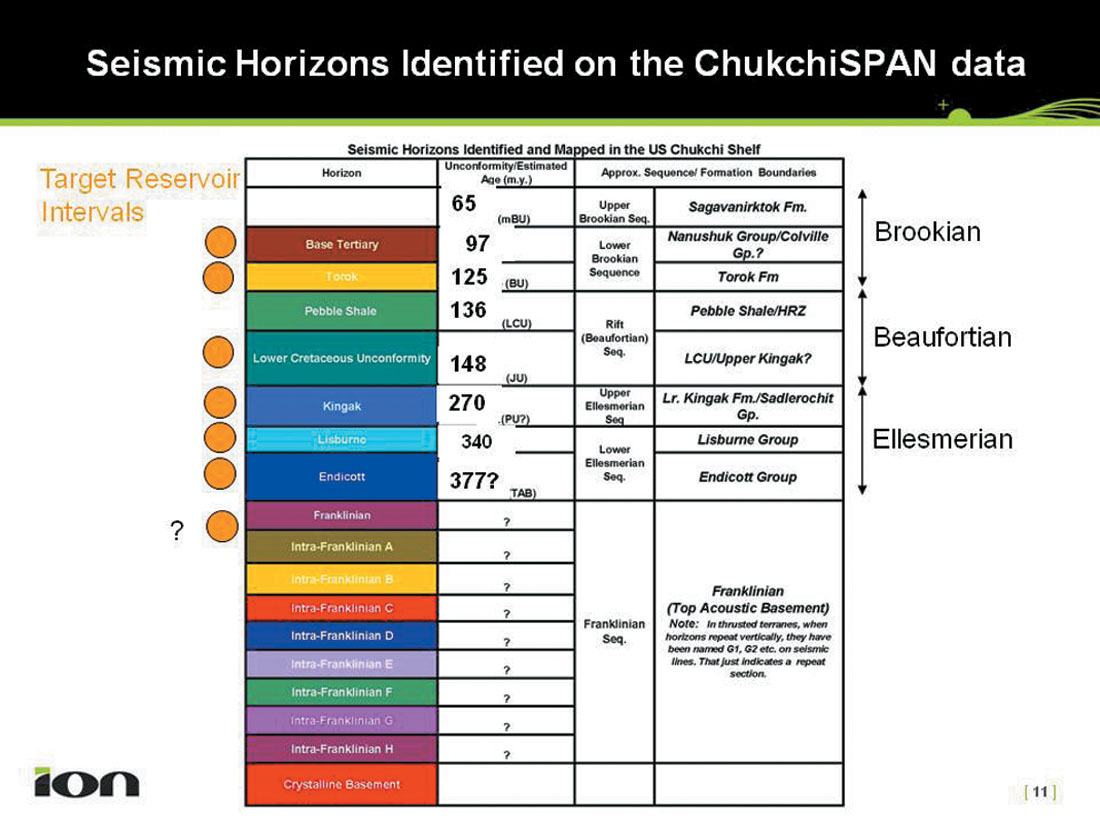
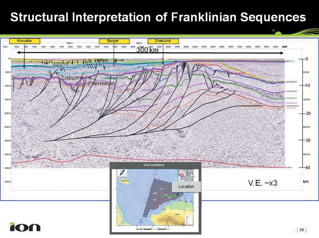
We have tied key seismic reflectors in the ChukchiSPAN data with formation tops from the exploratory wells. Based on these ties and regional geology, key reflectors identified and mapped are shown in Figure 6. Of course, some of the oldest reflectors have not been penetrated by wells, in particular, the multiple reflections identified within the Franklinian Sequence. This sequence has been described as “Acoustic Basement” by the MMS (2006), although Sherwood (1992) identified and mapped internal structures in this sequence in the northeast part (Arctic Platform) of the study area. As indicated in Figure 6, we have identified a series of internal reflectors within the Franklinian Sequence but have no constraints regarding their individual ages.
In addition, although not shown on Figure 6, we have interpreted a MOHO reflector on most of the SPAN data. The 40 km PSDM provides a sufficient record length to interpret this event. We are able to characterize the crust underlying the entire ChukchiSPAN data set as continental, and, therefore, no COB (continent-ocean boundary) is mapped in this data set. Gravity and magnetics data acquired along with the seismic data (D. Bird, 2007, pers. commun.) have allowed us to test our geological interpretations, especially the crystalline basement and MOHO picks, against gravity and magnetic models. In general, the seismic and potential-fields models have been iteratively modified to be mutually consistent.
The five exploratory wells drilled in the 1989-1991 period were primarily targeted to either test the Upper Ellesmerian Ivishak formation (productive in the Prudhoe Bay field on the North Slope of Alaska), or the Beaufortian (Rift Sequence) Kuparuk Sandstone (productive in the adjacent Kuparuk River field; Figure 5, MMS, 2006). However, the high-porosity, high-permeability Ivishak Fm that occurs at Prudhoe Bay was not penetrated in any of these wells either because it had been truncated by unconformities or because sandy facies do not occur at the drilled locations. Nevertheless, hydrocarbon shows were encountered in all the wells, thus documenting at least one active petroleum system in the region. In addition, the Burger well identified a significant hydrocarbon accumulation in the Kuparuk-equivalent sequence that has not yet been developed (Figure 7, Craig and Sherwood, 2004).
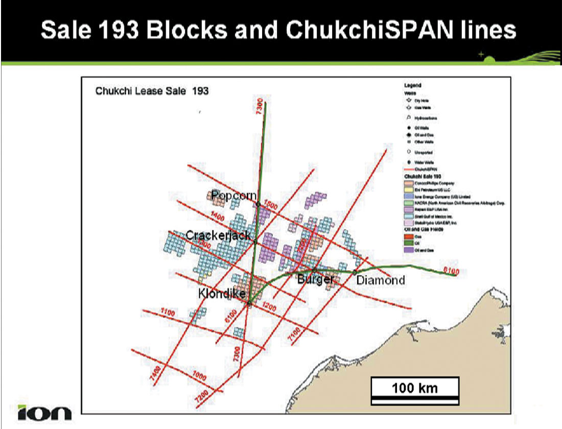
Our interpretation of the SPAN data shows that these wells did not fully test the prospects on which they were drilled. In addition, we suggest that other concepts in the basin remain untested. The industry appears to believe this as well, as shown by the February 2008 Sale 193 (Figures 4 and 7). These maps show that, in addition to new prospects in the Hanna Trough and on the Arctic Platform, the industry has leased the areas around the original Burger and Klondike prospects and has leased the flank of the Chukchi Platform to the west of the Crackerjack and Popcorn wells (Figures 4 and 7). Needless to say, we believe that the full potential of the basin is far from having been tested by the amount of exploratory drilling to date.
Seismic Interpretation
The exploratory target interval for Kuparuk Sands is situated between the LCU and Kingak reflectors and that for the Ivishak Formation between the Kingak and Lisburne reflectors (Figure 6). Additionally, the Lisburne-Endicott sequence (Figures 5 and 6) also contains significant potential reservoir intervals. Figure 8 is a composite section consisting of the northern part of line 7300 and the eastern part of line 6100 and traversing all five exploratory wells. Only the upper 10 km of the seismic data are displayed in this figure; the entire section (40 km) imaged by these lines is discussed later in this paper.
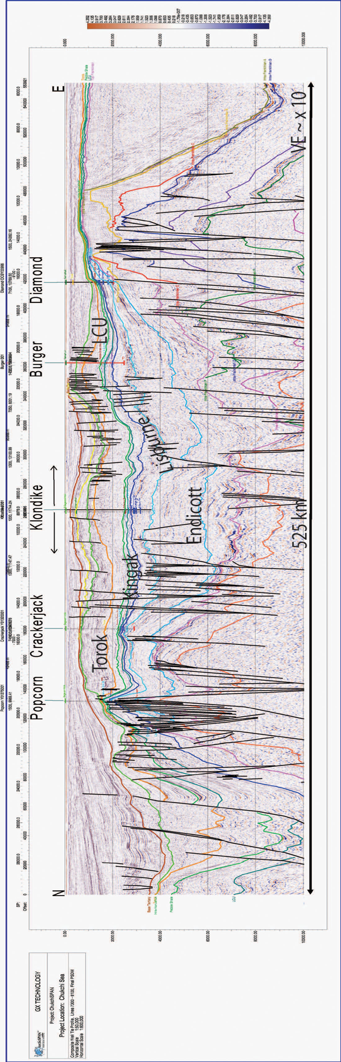
At the Diamond location, reservoir facies of Ivishak formation are present, but the hydrocarbon migration at this location was insufficient. We suggest that more attractive drilling locations are possible with additional detailed mapping in the area. Additionally, as shown in Figure 8, the LCU-Kingak interval and the Kingak-Lisburne interval are well developed in the vicinity of Burger and Klondike wells. At the Burger location, Craig and Sherwood (2004) estimate a mean resource of 14.0 trillion cubic feet of gas (400 billion cubic meters) and 724 million barrels of condensate (115 million cubic meters). Our data show the Burger feature to be almost 60 km across, hardly to be considered tested with a single exploratory well. Because the structure is so broad, the presence of oil leg below the gas accumulation cannot be discounted. Similarly, although the Ivishak Formation is not sandy, potential reservoir facies are present at the Klondike well in the Kuparuk interval, and the interval in the Lisburne-Endicott section was not tested. Again, for a structure almost 50 km across, a single well is inadequate to assess its hydrocarbon potential.
The Crackerjack and Popcorn wells were targeted as a stratigraphic wedge or a pinch out trap for the Ivishak Formation reservoir against or on a faulted and uplifted block, respectively (Figure 8). In both cases the Ivishak reservoir was absent. However, as is clear from the seismic data, both of these wells are located in areas of multiple unconformities and highly faulted structures and, therefore, require stratigraphic control that was not available when the first round of wells was drilled.
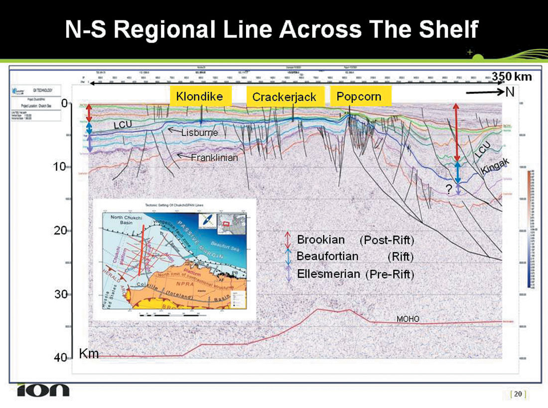
Figure 9 shows the entire 40-km record length of the north-south regional line 7300. Note that the left side of Figure 8 has the north direction reversed, as compared to Figure 9, and also shows an expanded version of the uppermost 10 km of data. The structure at Klondike, the stratigraphic wedge at Crackerjack, and the truncation and structural high at Popcorn locations are all apparent in Figure 9 even though the display extends down to 40 km. Aseries of listric normal faults creates accommodation space for the thick wedge of sediments in the North Chukchi Basin. The Popcorn structure is considered to be located on an extension of the Barrow Arch (Craig and Sherwood, 2004), so it is possible that most of the Ellesmerian section has been eroded to the north of this structure as is the case along the Barrow Arch adjacent to the North Slope of Alaska. Therefore, we have interpreted the Rift (Beaufortian) and Post-rift (Brookian) sequences only to form the almost 12 km of sedimentary wedge overlying the Franklinian sequence (Figure 6). The northernmost end of this line shows a structural high perhaps formed by rotation along the listric faults.
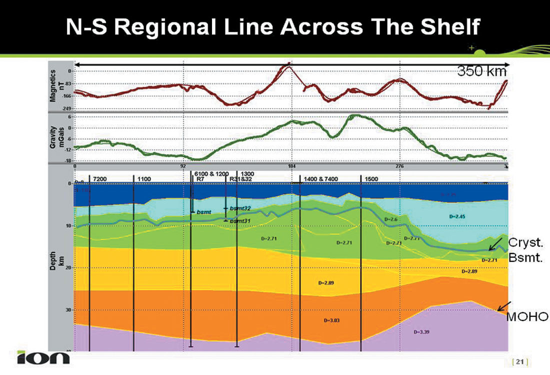
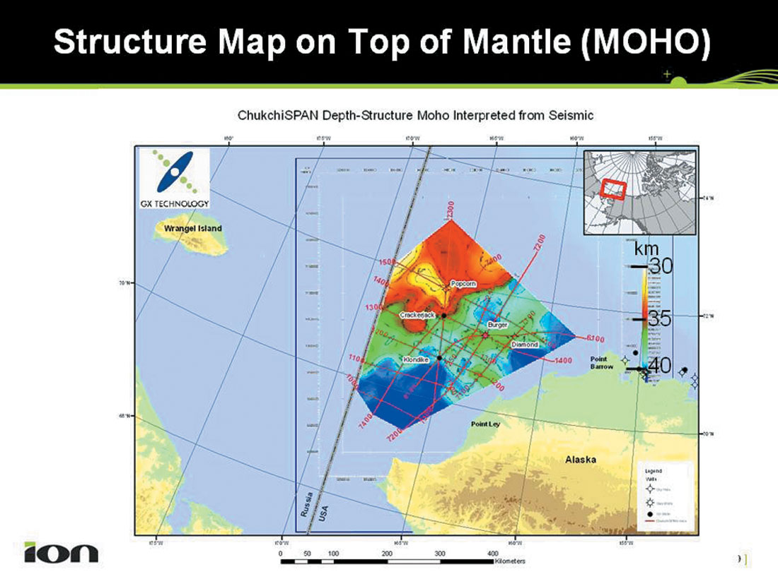
Figure 10 shows a density model for the line shown in Figure 9. The crystalline basement and the MOHO layers are identified on the density model. The model in Figure 10 supports the idea that the MOHO shoals from almost 40 km to 30-km depth towards the north end of Line 7300 (Figures 9 and 10). As suggested earlier, this might be a consequence of crustal stretching resulting from the clockwise rotation of the Chukchi Borderland (Figure 2). We have generated a map on the top of MOHO from our data (Figure 11). This map clearly shows MOHO located at depths greater than 40 km in the south, shoaling to 30- to 35-km depths in the north. Prior to our SPAN data, no regional mapping of MOHO in the Chukchi Shelf has been published, and the only previous observations of crustal structure have been based on limited seismic reflection and refraction data (Klemperer and et al, 2002).
One of the intriguing observations in the SPAN data has been the detailed imaging of basement-involved structures in the Franklinian sequence under the Arctic Platform whose flanks appear to be only mildly deformed (Figure 12). Sherwood (1992) recognized these structures and interpreted them in the context of a common Paleozoic history of the Chukchi Shelf and the Canadian Arctic Islands which were presumably connected prior to the opening of the Canada Basin. The SPAN data provide images of these structures in the depth domain for the first time, showing considerable detail within the Franklinian Sequence (Figure 6). The structure in Figure 12 can be interpreted as representing a history of early rifting and growth faulting, a subsequent inversion in which the rift-wall faults are reactivated and a footwall cutoff created within the Franklinian-sequence (Figures 6 and 12), and a later stage rifting (in Late Devonian) that formed further accommodation space for an expanded Ellesmerian section in the Hanna Trough (MMS, 2006). The Mesozoic rifting which formed the Canada Basin was thus only the youngest of several rifting events that have influenced the Chukchi Shelf. The vertically exaggerated section (top 10 km) on the right-hand side of Figure 8 and the display in Figure 12 show an undeformed eastward-dipping sequence of the youngest Franklinian rocks. Sherwood (1992) interpreted these as a sequence of clastics and carbonates equivalent to the Paleozoic clastic and carbonate sequences known from onshore and offshore areas off the Banks and other Canadian Arctic Islands ( Embry, 1990). We have interpreted these clastic and carbonate sequences in our BeaufortSPAN data (Dinkelman and et al, 2008) and have argued that there may be some petroleum potential in these rocks in Canada. By analogy there f o re, as has been suggested by MMS (2006), the potential of these moderately deformed Franklinian rocks in the Chukchi shelf cannot be discounted. We hope that future seismic and/or drilling will further investigate the hydrocarbon potential of these rocks.
Although admittedly regional in scope, the crustal scale of imaging provided by the SPAN data has provided significant insights into the evolution and geologic history of the US Chukchi Shelf. At the same time, we believe that, for “exploration depths” (<8 km for today’s technology), these data provide enough structural and stratigraphic detail to help identify areas which deserve infill seismic prior to the next round of exploratory drilling.
Conclusions
- Franklinian, Ellesmerian, Beaufortian and Brookian sequences have been identified in SPAN data. Our data demonstrate that the active petroleum system, documented by the first round of drilling in the US Chukchi Shelf, may provide a multitude of remaining exploration opportunities.
- The North Chukchi Basin contains almost 12 km thick sediments of Beaufortian and Brookian age. This basin has not been tested for hydrocarbon opportunities.
- The Franklinian sequence underwent a complex history of rifting, inversion, basement-involved thrusting, uplift and erosion.
- At least part of the Franklinian sequence is represented by mildly deformed Paleozoic rocks and may have some petroleum potential.
- Because of the 40-km PSDM, the MOHO discontinuity has been identified essentially throughout the survey. The MOHO shoals toward the north in the lee of the Chukchi Borderland indicating a “stretched” continental crust. This may support the idea of the Chukchi Borderland having undergone clockwise rotation away from the Alaska-Chukotka block.
- The SPAN data have permitted a crustal-level interpretation of the geology of the US Chukchi Shelf. However, the data also provide sufficient detail at “exploration depths” (less than ~8 km) to permit identification of areas where in-fill grids can identify stratigraphic and structural trapping opportunities for hydrocarbons.

Acknowledgements
We gratefully acknowledge various scientists of the Mineral Management Service and US Geological Survey for their help. In particular, we thank Kirk Sherwood of MMS; Ken Bird, Dave Houseknecht, Tom Moore and Don Gautier of USGS and Art Grantz, consultant (USGS re t i red) for providing access to published and some unpublished data. In addition, discussions with Geological Survey of Canada scientists, especially Tom Brent, Chris Harrison, Ashton Embry and Larry Lane have helped us in comparing the Chukchi Shelf geology with the geology of the Canadian Arctic Islands.


Join the Conversation
Interested in starting, or contributing to a conversation about an article or issue of the RECORDER? Join our CSEG LinkedIn Group.
Share This Article