When first asked to write an article about geophysical activity on Vancouver Island for the Recorder, I was hesitant. The small group of geophysicists have a diverse range of interests, thus making a complete portrayal of their activities difficult. On reflection, though, such an article would provide RECORDER readers with an overview of some of the geophysical activities taking place on the west coast and perhaps provide useful information for the future if the oil and gas moratorium on the west coast is lifted.
Although small in number, the geophysical community on Vancouver Island is quite active. Geophysicists work for the federal government, the University of Victoria (UVIC) and industry. We tend to focus on marine geophysics, earthquakes, seismicity and tectonics. Involvement in petroleum and mineral exploration, ground water exploration and environmental studies is more limited. The majority of geophysicists on the island are located at the Geological Survey of Canada Pacific and the University of Victoria. Graduate students and postdoctoral fellows provide an additional pool of local geophysical talent. Several geophysicists work at Terra Remote Sensing and as independent consultants. A few geologists conduct and interpret marine geophysical surveys as well. I expect a number of retired geophysicists live on Vancouver Island; if so they tend to keep a low profile. The CSEG 2000 membership photo directory listed two active members at the University of Victoria, plus four active members and two retired members elsewhere on Vancouver Island.
The Geological Survey of Canada Pacific (GSC Pacific) carries out geophysical surveys and research as part of their marine, earthquake and Cordillera studies. The present focus of the marine group is on mapping the sea floor and shallow sub-surface sediments on the continental shelf. For example, one current project concentrates on locating and identifying neotectonic features on the sea floor. Features associated with shallow faulting provide evidence for recent tectonic activity and are an important component of earthquake and seismicity investigations. This is a joint project with the U.S. Geological Survey, the University of Victoria and the Vancouver subdivision of GSC Pacific. The marine group is also carrying out environmental and geohazard studies within the Georgia Basin, mostly using existing data but collecting new data (multibeam and shallow seismic) when required. A more limited program with similar objectives is ongoing in Hecate Strait and Queen Charlotte Sound.
In addition, the marine group is involved in the Ocean Drilling Program (ODP). They work with international colleagues to investigate thermal and pressure effects associated with spreading centres and subducting plate boundaries. GSC Pacific and the Centre for Earth and Ocean Research at the University of Victoria (CEOR) are members of a research consortium with the United States, Japan and other countries studying gas hydrates, both offshore and onshore (McKenzie Delta). Members of GSC Pacific were on ODP cruises during 2002 to investigate hydrate accumulations offshore Oregon and British Columbia.
The earthquake studies group maintains the western Canadian seismic and GPS ground deformation networks. They monitor earthquake activity as well as locate the epicentres and compute magnitudes of all significant earthquakes. These data are used to investigate motion along plate boundaries and major faults and to develop models of tectonic processes. The measurement of geodynamic strain and absolute gravity is an integral part of the research. The information obtained from these measurements is used to calibrate mathematical models of isostatic rebound and stress buildup associated with tectonic activity. An integral component of this research is the development of mathematical models to predict strain and relative rates of motion along faults and plate boundaries.
The Cordillera geophysics group carries out magnetic and gravity surveys in support of regional geological mapping projects related to mineral exploration and neotectonic studies. The group also conduct paleomagnetic investigations to help unravel complex geological relationships and to provide calibration of the Quaternary stratigraphic time scale.
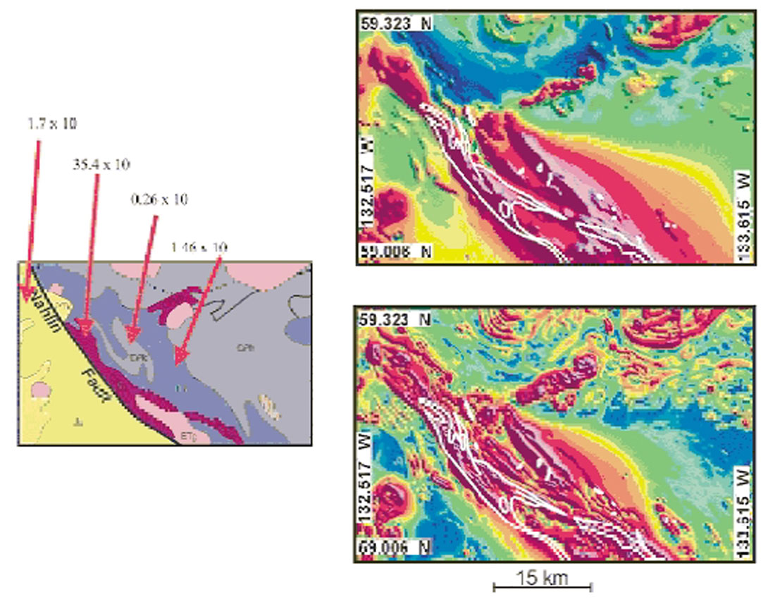
Two examples of the regional geophysical mapping program are the Atlin project and the Georgia Basin geohazard initiative. The objective of the Atlin project is to provide a modern data base, including publically available geophysical data, for the Atlin map sheet and to assess the mineral potential of the region. A high-resolution aeromagnetic survey was conducted over the region during the first year of the project (Fig. 1). Preliminary results from this survey indicate the southern portion of the survey area has been significantly more imbricated by ultramafic rocks than surface geological mapping indicates. This is important as most of the known gold placers and gold-bearing quartz veins in the region occur in, or are spatially associated with, ultramafic rocks.
The Georgia Basin project is being conducted as part of the Georgia Basin geohazard initiative. A 3D gravity model of the Georgia Basin was derived using a recently published seismic tomography model. The gravity model delineates four regions with thick accumulations of unconsolidated Pleistocene and younger sediments that were not resolved in the seismic model. Their recognition is particularly important for studies of seismic amplification and offshore aggregate assessment.
Several geophysicists conduct research within CEOR. Adjunct professors from industry and GSC Pacific enhance the range of geophysical expertise available to students within CEOR. CEOR geophysicists also teach a variety of geophysical courses at the School of Earth and Ocean Sciences at the University of Victoria (SEOS). Some of the adjuncts also teach part time within SEOS. Many graduate students at the University of Victoria have their research projects based on data from GSC Pacific’s western Canada seismic and GPS ground deformation networks.
CEOR scientists are involved in gas (methane) hydrate studies off the coast of Vancouver Island with GSC Pacific and the international consortium mentioned earlier. The range of expertise at the University of Victoria and within the GSC makes this group a leader in geophysical characterization of gas hydrates. The group’s approach has been multidisciplinary, including seismic methods (multichannel P-wave reflection, shallow high resolution acoustics, deep-towed multichannel reflection and ocean bottom seismometer studies). An investigation of the three dimensional structure of a cold seep that connects methane at the sea floor with free gas and hydrate at depths down to 250 m below sea level using tomographic inversion is one example of a thesis topic on this subject that is being pursued by a student. Other techniques being utilized are heat flow measurements, physical property analyses of piston cores and interpretation of geochemical measurements and downhole geophysical logs from ODP holes off Vancouver Island in 2000 and 2001.
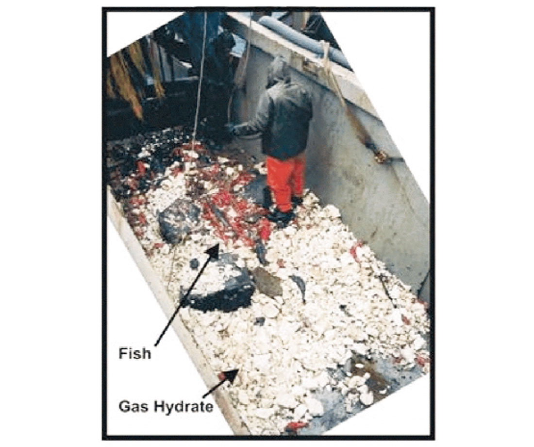
Recent dives using ROPOS (the Department of Fisheries and Oceans- remotely operated submersible vehicle) in August, 2002 obtained hydrate samples from the seafloor at a site where a fishing trawler had dredged up more than a ton of hydrate from the seafloor a year earlier (Fig. 2). The hydrate outcrops observed on the seafloor were associated with oil and gas bubbling and massive clam colonies. Graduate students have been key members of the methane hydrate research group, and will continue to be. The combined effort between the University of Victoria, GSC Pacific and Japan has made the Vancouver Island margin probably the best-studied occurrence of hydrates in the world.
Geophysicists at the University of Victoria and GSC Pacific have made major contributions to the understanding of the history and dynamics at the continental margins off Vancouver Island and the Queen Charlotte Islands, where the earthquake hazard is similar to that of California or Japan. To determine crustal-scale structure and plate deformation at the transition between the oceanic and continental plates, many geophysical methods are applied (seismic, gravity, magnetics, heat flow, surface deformation measurements, and computer modelling of deformation).
Geophysicists from the University of Victoria and GSC Pacific were the major organizers and participants in the international SHIPS program (Seismic Hazards Investigations in Puget Sound), which collected multichannel reflection and wide-angle seismic data to constrain seismic hazard in southwestern B.C. and northwestern Washington. These same geophysicists are members of a large international collaborative project on the Cascadia margin (CASSIS), which, together with Japanese researchers, aims to collect state-of-the-art reflection and onshore/offshore wide-angle data to understand seismicity and structure off Vancouver Island.
CEOR is using Quester Tangent (a local Vancouver Island high technology company) sea bed classification technology in conjunction with high resolution seismic to assess geohazards associated with gas seeps in Hecate Strait. This project is related to the potential development of west coast offshore oil and gas sometime in the future. This project is part of an ongoing joint venture arrangement between Quester Tangent and CEOR on the application of seabed classification technology to diverse seabed issues. For example, a new project between CEOR/Quester Tangent and fisheries in Greenland has been initiated to study marine habitat in the Labrador Sea.
Terra Remote Sensing Limited, another Vancouver Island technology company, carries out marine geophysical surveys (high resolution seismic, multichannel seismic, sidescan, multibeam, deep tow surveys, magnetics) for electrical and telecommunication cable route planning, pipeline route planning and other seabed studies. Geophysicists with Terra have experience in performing site surveys for oil and gas drilling. They also have experience executing land geophysical surveys for cable and pipeline route planning. Terra also has groups involved in airborne surveying (lidar, video) and GIS/data base projects.
I hope this article has provided an overview of geophysical activities on Vancouver Island and has illustrated the diversity of our geophysical endeavours. The interaction between local geophysicists and the CSEG is quite limited at the present time. Generally UVIC students are unaware of the CSEG and its role in petroleum exploration and production. Although this article may help CSEG members understand the breadth of activities being carried out on Vancouver Island, the reverse is not true. The local geophysical community, particularly students, on Vancouver Island are generally not aware of CSEG activities. I suggest the CSEG executive would enhance CSEG presence here by offering a yearly seminar at the University of Victoria, thus creating at least a limited interaction between the CSEG, UVIC students and other local geophysicists.


Join the Conversation
Interested in starting, or contributing to a conversation about an article or issue of the RECORDER? Join our CSEG LinkedIn Group.
Share This Article