Abstract
Alberta contains substantial coal resources in the Plains and Foothills. Coal rank ranges from lignite and subbituminous in the eastern Plains, up to low-volatile bituminous and anthracite in the Foothills/Mountains. Potential coalbed methane targets exist in the Scollard Fm. (Ardley coal zone), Horseshoe Canyon Fm. (Carbon-Thompson, Drumheller coal zones), Belly River Gp. (Lethbridge, Taber, McKay coal zones) and the Mannville Gp. within the Plains, and in the Kootenay, Gething, Gates, Brazeau and Coalspur coal zones of the Foothills/Mountains. Coal cleating and permeability is variable across the province. Maximum gas-in-place for all of the coal in Alberta is estimated to be in the order of 1.42 x 10¹³m3 (500 tcf). Although this number is large, the actual amount able to be produced remains unknown, in part due to limited data on gas concentration, permeability and production constraints.
Introduction
Alberta contains vast amounts of coal distributed throughout the southern Plains, Foothills and Mountains. Originally deposited in relatively flat-lying peat swamps, organic matter (peat) was buried by sediments derived from uplift (mountain building) in the west, and gradually changed into coal with increasing heat and pressure of burial. Over time the coals were in turn uplifted and partially eroded away, resulting in the present distribution of coal across the Plains (figure 1).
Coal-bearing strata gently dip westward towards the Mountains, where the coals are folded and abruptly turn towards the surface to be exposed in the Foothills.
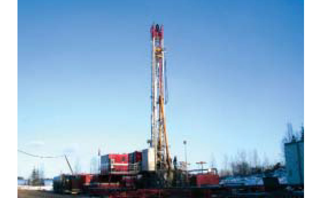
Commonly, mines are located where the coal comes to the surface. The EUB estimates there are 91 billion tonnes of coal resources at depth suitable for mining. There is an additional 2 trillion tonnes of coal at depth in the Alberta Plains that may be suited for CBM exploration. Coal in the Foothills and Mountains would also significantly add to this tonnage.
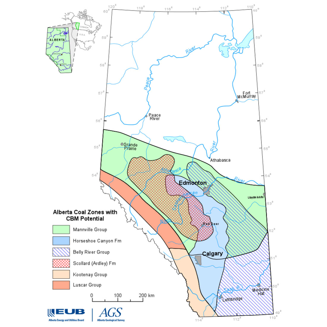
Packages of coal occur within distinctive horizons of the Scollard, Horseshoe Canyon, Belly River and Mannville strata in the Alberta Plains, and within the Coalspur, Luscar and Kootenay strata of the Foothills (figure 2).
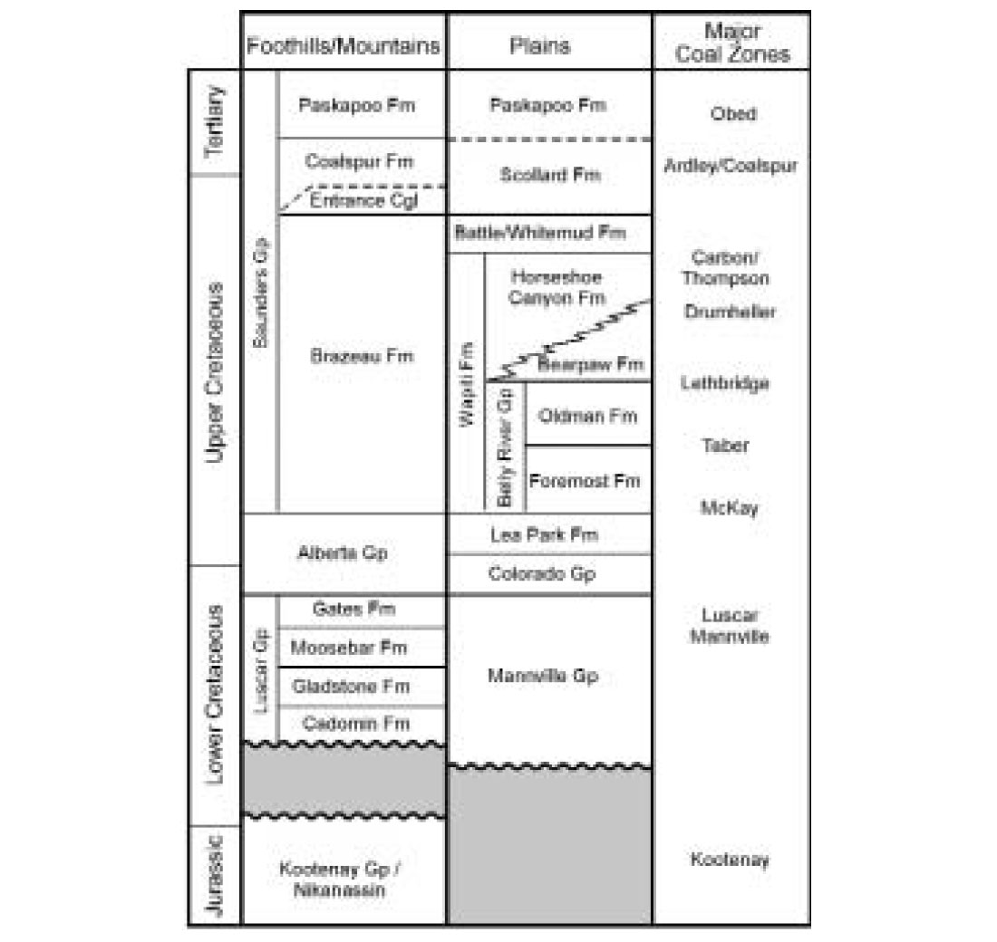
These coal packages are referred to as ‘coal zones’, which are laterally continuous intervals of interbedded coal and inorganic partings. There is no defined minimum or maximum thickness of interbedded sediment that defines a coal zone. Nevertheless, the individual zones commonly contain several metres of net coal over a relatively small stratigraphic interval (in the order of several metres), and individual coal zones are separated from one another by several metres (30-50 m) of rock. Coal rank trends in Alberta are presented in figure 3. Most coals at shallow depths (<1000 m) in the Plains are within the rank range of sub-bituminous to high-volatile bituminous C-B. Coals from the Foothills are generally more mature, with ranks ranging from high-volatile bituminous B to low-volatile bituminous.
Coal maturation and CBM generation
Coal is a carbon-rich rock derived from plant material (peat) that accumulated in swamps, and was subsequently buried by ongoing geological processes. With increasing depth of burial, the plant material undergoes coalification, releasing volatile matter (water, carbon dioxide, light hydrocarbons including methane) as it begins to transform into coal. With ongoing coalification, the coal becomes progressively enriched in carbon and continues to expel volatile matter. Generation of methane and other hydrocarbons is a result of thermal maturation in coals, and begins around the Subbituminous Ato High Volatile Bituminous “C” rank stage, with amounts of methane generated increasing significantly throughout the Medium- to Low Volatile Bituminous coal ranks.
Biogenic gas (gas generated by bacterial processes) may be produced during the early coalification stages and be retained in the coal. Later-stage biogenic gas may be generated resulting from groundwater invasion into the coals.
Gas is stored in coal as an adsorbed component on or within the coal matrix, and as free gas within the micropore structure or cleats within a coal bed. The gas is held in place mainly by reservoir pressure; reducing the reservoir pressure allows gas to be released from the coal.
Coal-bearing strata in Alberta
Scollard and Coalspur Formations:
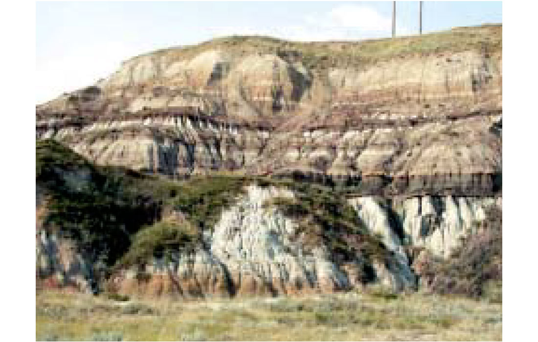
The Scollard Formation consists of thick, grey- to buff-coloured sandstone and siltstone interbedded with thin shale and coal. Two units are recognized in the Scollard Formation. The lower (barren interval) and upper (coal-bearing) members are separated by the basin-wide Cretaceous-Tertiary (K-T) boundary (Sweet and Braman, 1992). The upper Scollard contains the thick, widespread Ardley Coal Zone. The K-T boundary is located near the base of the Ardley Coal Zone.
There is one major coal zone within the Scollard Formation, the laterally continuous and thick Ardley Coal Zone (figure 4a,b). Maximum individual seam thickness and number of seams are greatest in the western part of the Plains, where peat accumulation was accentuated by increased subsidence, coupled with protection from clastic input by major river systems running parallel to the mountain front (Richardson et al., 1988).
The Coalspur Formation is the Foothills’ equivalent of the Scollard Formation (Jerzykiewicz, 1997). Coalspur Formation nomenclature subdivides the coal zone into four coal ‘subzones’. These ‘subzones’ are identified from upper to lower as the Val D’Or, Ardley, Silkstone and Mynheer coal zones (figure 5). All seams/zones are present in the western and central portions of the Plains, although the upper seams are absent toward the east. The average thickness of the Ardley Coal Zone ranges from 14 m near outcrop to greater than 200 m near the western margin of the Plains. Furthermore, the number of seams increases from an average of four near outcrop to as many as 18 at depth (600-800m) near the western limit of the Plains.
Coal rank within the Ardley ranges from sub-bituminous near outcrop (reflectance <0.5%) to a maximum of high-volatile bituminous B at depth in the western Plains. Most of the area underlain by Ardley coal falls within reflectance range 0.5 to 0.65% (high-volatile bituminous C rank), just within the onset of thermogenic- gas generation (Rice, 1993).
Permeability within the Ardley coal zone is generally low (figure 6). Limited data suggests a wide range of permeability, ranging from <0.1 mD up to 7mD (Dawson et. al, 2000), with the lower values being reported from the northern areas including Pine Creek and the elevated values occurring in the central Pembina area. More data is needed to fully characterize permeability range and distribution in the Ardley coal zone.
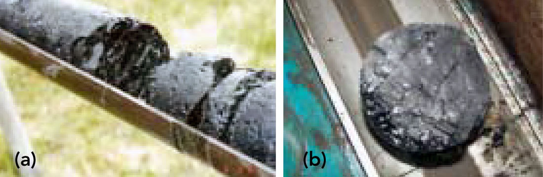
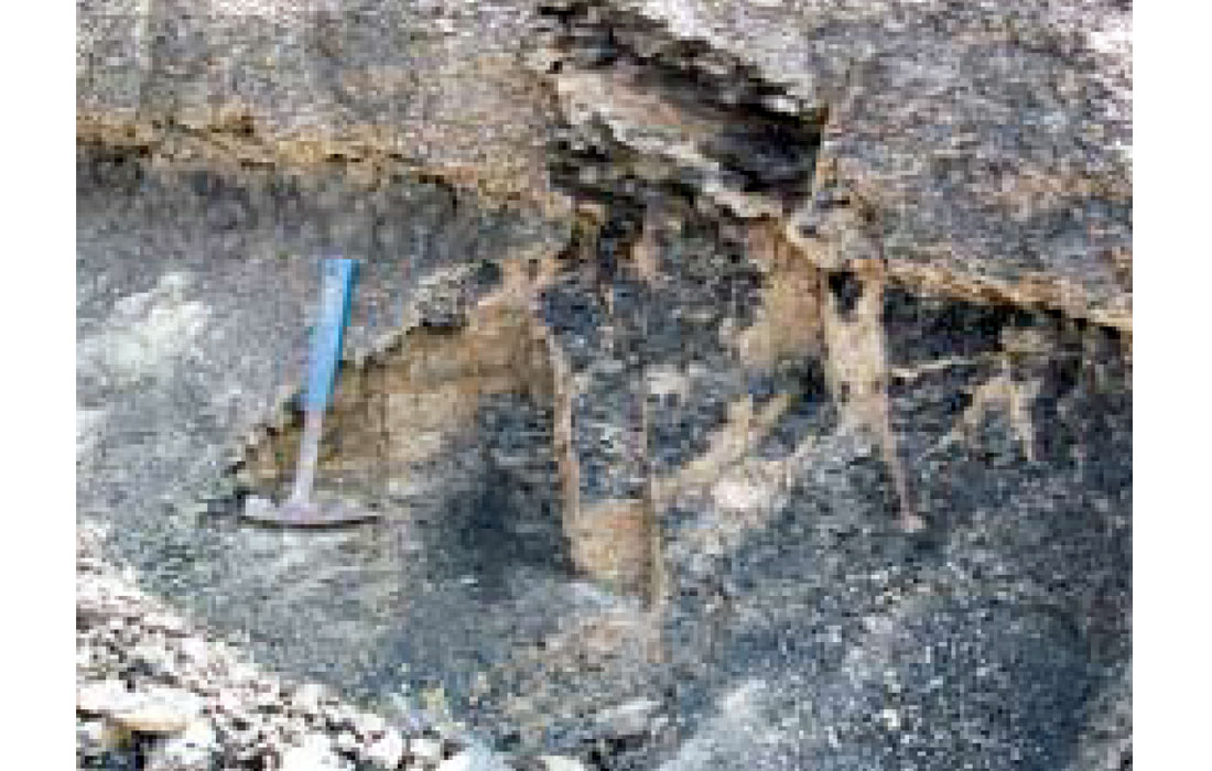
Figure 6b. Coal cleat in core of the Ardley Coal Zone - CBM exploration core, approximately 300m depth.
Horseshoe Canyon Formation:
The Horseshoe Canyon Formation consists of an approximately 250 m thick succession of nonmarine sandstone, siltstone, shale and mudstone that contains coal, coaly shale, ironstone concretions and isolated bentonite beds (Gibson, 1977). The lower part of the Horseshoe Canyon Formation includes alluvial, lacustrine, lagoonal, swamp and beach facies (Rahmani, 1988). Toward the top of the Horseshoe Canyon Formation, clastic sediments were deposited in a fluvial environment.
The base of the Horseshoe Canyon Formation is identified at the contact with the underlying Bearpaw Formation in the southern Plains area. There are several marine tongues that may interfinger with Horseshoe Canyon sedimentary units.
Horseshoe Canyon coal seams are generally elongate and interfingered with clastic and marine strata; although generally thin, these coals can attain local thickness exceeding 4 m.
Coal Zones of the Horseshoe Canyon Formation:
Three coal zones occur in the Horseshoe Canyon Formation: the Drumheller Coal Zone (divisible into upper and lower intervals), the Daly-Weaver Coal Zone and the Carbon-Thompson Coal Zone.
Thick net coal accumulations are present in the Drumheller Coal Zone (figure 7) with local net accumulations up to 18 m but the coals are somewhat discontinuous. A north-trending zone of thick net coal (average 8 m net coal) occurs in the southern region of the Alberta Plains. Individual seams average 1 to 2 m thick, although seams may be up to 4 m thick in areas of greatest net coal (McCabe et al., 1989; Rottenfusser et al., 1991).
Discontinuous coal seams of the Daly-Weaver Coal Zone occur stratigraphically above the Drumheller Coal Zone. McCabe et al. (1989) suggested that the Daly-Weaver Coal Zone formed in an alluvial plain setting, where only thin, discontinuous seams are developed.
The upper Horseshoe Canyon Formation contains the discontinuous but laterally persistent Carbon-Thompson Coal Zone. The thickest coals in the Carbon-Thompson Coal Zone occur in northwest- trending ‘bands’ in the central Alberta Plains that coincide with northwest-trending paleochannels associated with fluvial depositional environments. Thickest coals rarely exceed 1-2 m, and net coal for the zone averages 2-3 m (Nurkowski, 1980).
Rank of coals in the Horseshoe Canyon Formation ranges from sub-bituminous to high-volatile bituminous. Carbon-Thompson coals are primarily within the ‘upper bounds’ of high-volatile bituminous C rank, with reflectance values in the 0.6 to 0.65% reflectance range. Data are sparse for the Daly-Weaver Coal Zone; however, it is expected to follow a rank trend similar to that of the Carbon-Thompson Coal Zone. The Drumheller Coal Zone includes low-rank coal (sub-bituminous B-A) at shallow depths, to high-volatile bituminous C in the deeper Central Plains region.
Permeability data is lacking for Horseshoe Canyon coals. Initial results suggest permeability is greater than in the Ardley coal zone, potentially in the 3-5mD range (figure 8 a,b).

Belly River Group:
The Belly River Group represents an eastward-thinning sedimentary wedge, composed of clay, silt and sand deposited in a predominantly nonmarine environment. This succession occurs stratigraphically between the overlying Bearpaw Formation and the underlying upper Lea Park Formation.
The Belly River Group has two distinctive lithological units. The lower unit (Foremost Formation) represents a succession from shoreline to alluvial plain deposits and contains two coal zones. The upper unit (Oldman Formation) consists of fine-grained floodplain and lacustrine deposits containing one coal zone near the top. Hamblin and Abrahamson (1996) introduced the Dinosaur Park Formation in the uppermost part of the succession, above the Oldman Formation.
Coal Zones of the Belly River Group:
The McKay Coal Zone represents the first major peat accumulation associated with coastal plain sediments of the lower Belly River Group (Foremost Formation). Average net coal thickness ranges from 1 to 3 m; however, in some local areas, up to 4 m net coal may be present. Individual seams typically range between 1 and 3 m thick (Macdonald et al., 1987).
The Taber Coal Zone developed eastward of the McKay Coal Zone in response to continued regression of the interior seaway. The Taber Coal Zone occurs near the top of the Foremost Formation and contains 1 to 3 m thickness of net coal. Thicker coals occur locally (up to 6 m net coal) in northeast-trending bands. Individual seams range from 1 to 2 m thick.
The Lethbridge Coal Zone developed as a result of rising regional water-table levels associated with the advancing Bearpaw seaway. The coals are laterally continuous, and occur near the top of the Dinosaur Park Formation. The Lethbridge Coal Zone has an average of 1 to 3 m net coal that commonly occurs in two seams.
The McKay Coal Zone displays a wide range of coal rank. Shallow coals are typically sub-bituminous B to A and, in the deeper Central Plains, increases to high-volatile bituminous C rank. The Taber Coal Zone is predominantly high-volatile bituminous C in the Central Plains, and sub-bituminous C to B in the southeastern Plains. Only in the far western Plains does rank approach high-volatile bituminous B. The rank of the Lethbridge Coal Zone ranges from sub-bituminous at shallow depths through high-volatile bituminous C and B westward with increasing depth. Coal rank approaches high-volatile bituminous Ain the west-central part of the Plains. Permeability data for Belly River coals is not available at present in the public domain.
Mannville Group:
The Mannville Group overlies a major unconformity that separates Paleozoic from Mesozoic strata in Alberta. The lower Mannville shows a progression from fluvial to lacustrine-marginal marine environments. The middle Mannville consists of shoreline and near-shoreline deposits, prograding into estuarine and fluvial deposits. In southern Alberta, coals were developed over beach and coastal plain deposits. The upper Mannville represents a prograding clastic wedge that includes several regressive/transgressive cycles. Cycles commonly consist of marine shale overlain by “offshore bars, barrier islands, or deltaic sandstone” (Rottenfusser et al 1991), culminating in coastal plain deposits capped with thick coals.
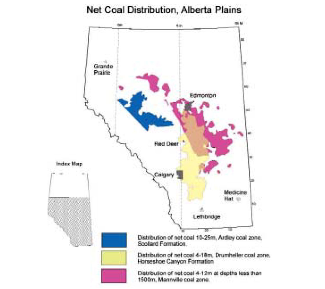
Thick, widespread Mannville coal occurs in the Red Deer area, with 6-12 m of net coal. In the deep basin and westward toward the deformed belt, net coal can exceed 14 m; however, net coal is generally in the range of 6-10 m.
Gething Formation coal (Mannville equivalent) occurs in west-central Alberta Foothills. Numerous thick but laterally discontinuous coals, deposited within an upper to lower deltaic environment, average 2-4 m net coal in western Alberta.
The Gates Formation (Luscar Group) in the central and northern Foothills of Alberta contains coal within two members (figure 9).
The Grande Cache Member has thick, extensive coals deposited in a coastal plain setting. The overlying Mountain Park member consists of thinner, less numerous coal seams deposited in a fluvial environment.
Mannville coals from the Alberta Plains typically have a rank of sub-bituminous to high-volatile bituminous in the north and east. Rank increases with depth westward. In the central Plains, rank is within the high-volatile bituminous C-A range, within the thermogenic- gas generation window for coals. Medium- to low-volatile bituminous coals occur along the western margin of the deep basin and the disturbed belt, although they are at greater depths than the Plains coals. Gates and Gething coals range in rank from high-volatile bituminous to anthracite.
Permeability varies considerably in the Mannville coals. Results ranging from <0.1 mD to 4mD have been reported by Dawson et al. (2000), and Sloan and McKinstry (2002).
Kootenay Group:
The Jurassic-Cretaceous Mist Mountain Formation of the southern Mountains and Foothills consists of a thick nonmarine sequence of shale, siltstone, sandstone and coal, developed in a coastal plain setting. Cumulative coal thicknesses in the order of 12 m are present at depth near Pincher Creek. Generally, coal in the Mist Mountain Formation thins from west to east, and much of the thickest coal occurs in British Columbia. Coal rank ranges from high-volatile bituminous Aup to semi-anthracite, within the thermogenic-gas generation window.
Coalbed-Methane Potential of the Alberta Plains as Related to Coal Distribution
Coal distribution, including net coal thickness, rank and depth to top of the coal zones, has been previously discussed for the Alberta Plains by Rottenfusser et al. (1991) and Beaton et al. (2002), and for the Foothills by Langenberg et al. (2002) From total coal resources (in place), maximum CBM gas-in-place has been calculated to be 5.27 x 10¹² m3 (186 tcf) for Upper Cretaceous coals of the Plains (Beaton et al., 2002), 3.68 x 10¹² m3 (130 tcf) for the Foothills (Langenberg et al., 2002) and 1.13 x 10¹³ m3 (400 tcf) for Mannville coals of the Plains (MacLeod et al., 2000). Much of the Foothills coals, and Mannville coals of the Plains is at depths deeper than 1500m, and may pose significant challenges to CBM development.
Maximum Gas-in-Place, Ardley Coal Zone, Alberta Plains:
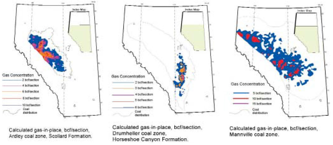
The Ardley Coal Zone contains the thickest net coal accumulations in the Plains, in some areas exceeding 20 m net coal. Two main trends of thick net coal are present: a northeast-trending zone in the Edson-Pine Creek area and an east-trending zone in the Pembina area. Both of these areas are situated in subregional ‘troughs’ within the Ardley, where depth of strata is slightly greater than surrounding areas. Gas concentrations typically range from 3-4 cc/g (dry ash-free basis). Gas-in-place calculations indicate that the most favourable CBM potential in the Ardley Coal Zone is associated with these two areas. Within these two areas, gas-in-place exceeds 4 bcf/section, with the thickest net coals contributing 6-8 bcf/section (figure 10). These two areas have so far been the main focus of CBM exploration in the Ardley Coal Zone.
Maximum Gas-in-Place, Horseshoe Canyon Coal Zones, Alberta Plains:
The Horseshoe Canyon Formation contains three coal zones. The uppermost zone, the Carbon-Thompson Coal Zone, is generally thin (<2 m); however, local pods of coal occur with 3-4 m net coal thickness in the Red Deer area. Gas-in-place has been calculated for the Carbon-Thompson Coal Zone. Most areas have generally low potential (<1 bcf/section), although two areas, one northwest of Calgary and the other west of Edmonton show elevated gas concentrations, in the order of 1 bcf/section, with thicker coal pods containing up to 1.5 bcf/section.
The Daly-Weaver Coal Zone is very discontinuous and of variable thickness. It has not been a target of CBM exploration to date.
The Drumheller Coal Zone is the main target in the Horseshoe Canyon. Average gas content is low, in the 0.75-1.5 cc/g (dry ash free basis). Net coal thickness greater than 4 m encompasses a large area within the Central Plains, extending from township 12 to 50 and from range 20W4 to the fifth meridian. Within the centre of this distribution, net coal exceeds 10 m, and pods of coal in excess of 18 m are present. Within this trend, which has typical gas-in-place concentrations of 1-2 bcf/section, there are elongate areas where gas-in-place exceeds 3 bcf/section (figure 10). These areas of thick coal are undergoing active CBM exploration, and the first commercial production of CBM in the province was reported from this area, with multi-zone completion wells typically producing 75-150 mcf/day (Canadian Discovery Digest, 2002).
Maximum Gas-in-Place, Belly River Coal Zones, Alberta Plains:
The generally thin coals of the Belly River Group have undergone very limited explorations. Much of the coal zone with net thickness greater than 3 m is at relatively shallow depth. Because a shallow depth suggests low reservoir pressures, the gas content of these coals is expected to be low. These factors are reflected in the gas-in-place calculations.
Coal zones of the Belly River Group contain thinner net coal than the overlying Drumheller Coal Zone. Furthermore, areas of net coal greater than 2 m are generally discontinuous. The Lethbridge Coal Zone contains a few areas of interest, the main one being a trend containing net coal thickness of 3-4 m just north of Lethbridge. The areas showing most promise for CBM potential have overall low gas-in-place concentrations, at less than 0.75 bcf/section, although there are some elongate coal pods that may exceed 1 bcf/section.
The Taber Coal Zone includes a north-northwest trending zone, extending from Twp. 3, Rge. 5, W 4th Mer. to Twp. 29, Rge. 15, W 4th Mer., that contains 3-4 m net coal. Similar in CBM potential to the Lethbridge Coal Zone, much of the Taber Coal Zone is relatively shallow and/or has thin net coal. Some limited areas of the Taber zone show gas-in-place potential of 0.75-1 bcf/section, but most of the coal zone has 0.5 bcf/section or less gas-in-place.
The McKay Coal Zone has a much more discontinuous distribution of coal, with several small areas with net coal greater than 3 m distributed throughout a trend encompassing Twp. 10 to 60, Rge. 11 to 25, W 4th Mer. The discontinuous nature of the coals result in numerous small coal pods, some with gas-in-place concentrations in the 0.75-1 bcf/section range. Most coals in the McKay Coal Zone are thin and have limited gas-in-place potential (0.5 bcf/section and less).
Maximum Gas-in-Place, Mannville Coal Zone, Alberta Plains:
The Mannville group contains several large areas where seams are continuous and net coal exceeds 4 m in a northwest-trending zone extending from the Alberta-British Columbia border, just south of Grande Prairie, to Twp. 10, Rge. 30, W 4th Mer. in east-central Alberta. Within this zone, large areas with net coal greater than 6 m occur, and net thickness greater than 8 m are common. Reported high gas contents (8-12 cc/g, dry ash-free basis), thick net coal and the potential for structurally enhanced permeability have made the shallower (<1500 m depth) Mannville coals an attractive CBM target (Allan, 2003).
Gas-in-place calculations for Mannville coals show that most of the zone with greater than 4 m net coal thickness may contain at least 5 bcf/section (figure 10). Local areas with 8 m or more net coal may contain up to 10 bcf/section.
Coal Cleat – permeability pathways for fluid production
Mountain building processes in British Columbia and the western parts of Alberta (Rocky Mountains) have produced great compressional stress in the coal and rocks. This stress contributed to the formation of a series of tight, closely-spaced small near-vertical fractures in the coal beds, referred to as “cleat”. Cleat is thought to develop as a function of coal shrinkage (compaction, dewatering and devolatilization) under stress, and cleat orientation is commonly perpendicular to the deformation trend. Coal cleat is important in enhancing CBM potential, as it is these interconnected fracture networks (permeability) that allow fluids (water and gas) to move through the coals and into a wellbore for production. Coal cleats are generally more open near surface, but with increasing depth, the weight of the overlying rock compresses or closes the cleat, reducing permeability within the coal seam. Cleat may be enhanced in areas of faulting, fracturing or where coal seams may be draped over sandstone channels. CBM companies are always on the lookout for areas of enhanced permeability to improve their exploration success potential.
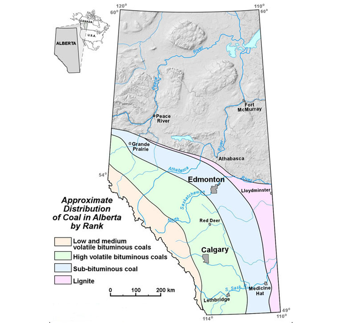
Coal Rank, Depth of Cover and CBM Potential
The rank of coal in Alberta ranges from very low (lignite), to high (anthracite). Coal near the surface in the Plains is generally of subbituminous rank, with lignite occurring in the north and northeast part of the Plains, and high volatile bituminous C in the northwest and southwest areas of the Plains. Coals near the surface in the Foothills generally are of high volatile bituminous C, with minor amounts of high volatile bituminous B and A - ranked coals in some areas. In the Mountains area west of the Foothills, coal ranks of medium and low volatile bituminous rank occur, with local occurrences of anthracite near the Canmore area. Low rank, shallow Plains coals are used mainly for heating and power generation. Higher-rank coals of the Mountains and Foothills are suitable for metallurgical applications (steelmaking).
Coal rank increases with burial depth. In the Plains, coal rank increases towards the west, as seams dip and become progressively deeper towards the mountains. CBM content increases with increasing rank (thermal maturation), so that with greater seam depths, gas contents are expected to increase. With increasing depth also comes increasing overburden pressure, which may restrict permeability by closing coal cleats. A challenge in CBM exploration is finding coals with ranks suitable for gas generation, but not so deep as to restrict permeability.
Horseshoe Canyon coals with relatively low gas contents but moderate permeabilities are being successfully exploited for CBM production in the south-central Plains. Mannville (and correlative) coals are showing potentially favourable permeability and high gas contents in some locations, and are undergoing evaluation in the southern Foothills and the northeastern to central Plains. Ardley coals have moderate gas contents, and in general show low permeability, although in the Pembina area production potential is being evaluated.
Summary of Coalbed-Methane Potential, Alberta Plains
Total coalbed-methane potential (maximum gas-in-place) of the Alberta Plains has been calculated at 1.50 x 10¹² m3 (53 tcf) for the Ardley coal zone, 3.97 x 10¹¹m3 (14 tcf) for the Carbon-Thompson, 3.97 x 10¹¹m3 (14 tcf) for the Daly-Weaver, 1.08 x 10¹²m3 (38 tcf) for the Drumheller, 5.10 x 10¹¹ m3 (18 tcf) for the Lethbridge, 5.67 x 10¹¹ m3 (20 tcf) for the Taber and 7.93 x 10¹¹ m3 (28 tcf) for the McKay (Beaton et al., 2002). Mannville coals may contain up to 1.13 x 10¹³ m3 (400 tcf) of gas-in-place (MacLeod et al., 2000). The above estimates do not take into account minimum seam net thickness or production constraints.
The maximum gas-in-place potential for the main coal zones of the Alberta Plains have been presented above. Within the Ardley coal zone, the thick coal trends in the Pine Creek and Pembina areas are potential exploration targets (figure 11).
The Carbon-Thompson and Daly-Weaver coal zones are limited in potential. The thick coal trends in the Drumheller Coal Zone present a potential CBM target.
Although gas concentrations are low, the relatively shallow depth and numerous seams, as well as potentially greater permeability compared to the Ardley Coal Zone, make the Horseshoe Canyon coals a viable and, to date, a successful CBM target. Limited potential exists for Belly River coals. A few local thick pods of Lethbridge and Taber coals occur, but they present small targets of limited extent and gas potential. There are some areas where the stratigraphic separation between the Drumheller and Lethbridge coals is minimal (a few tens of metres), therefore it may be possible to target both coal zones within one CBM well. Limited data suggest some Belly River coals may have greater gas contents than Horseshoe Canyon coals, which may favour multizone completions.
Mannville coals have been shown to have favourable gas contents, much higher than most Upper Cretaceous-Tertiary coals of the Alberta Plains. Previous work suggests permeability is low in much of the Mannville coals (0.1-2 mD), and that much of the Mannville coal occurs at depths greater than 1500 m. Shallower Mannville coals still include thick net coal (>4 m) and therefore present viable exploration targets, particularly where there are thickness anomalies that may be related to underlying structure. It is suggested that these anomalies may also have enhanced permeability (Allan, 2003).
Summary of Coalbed-Methane Potential, Alberta Foothills
Coal occurs in the Alberta Foothills in five main coal zones, the Kootenay, Gething, Gates, Brazeau and Coalspur coal zones. Structural deformation and overthrusting has effectively created two “coal horizons”, the upper horizon occurring at depths less than 1000m, and the lower horizon with depths greater than 1000m. The shallow coal horizon has a maximum in-place gas resource of 878 x 109 m3 (31 tcf). Deeper coal resources have a maximum gas-in-place resource of 2.8 x 10¹² m3 (99 tcf) (Langenberg et al., 2002). Coal distribution and gas calculations are based on limited drillhole data, and therefore resource numbers must be used with caution.
The only limited Foothills production has been from the southern Alberta Kootenay zone. The shallow Gates coal zone in central and northern Foothills is prospective for CBM, as is the Coalspur coal zone in the Edson area (Entrance Syncline and Triangle Zone).


Join the Conversation
Interested in starting, or contributing to a conversation about an article or issue of the RECORDER? Join our CSEG LinkedIn Group.
Share This Article